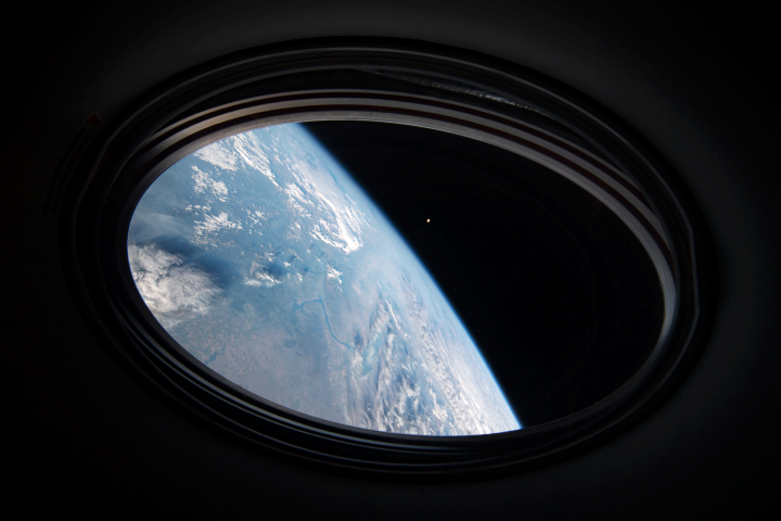
What does Earth look like from 98 miles up? A project developed by Colorado community college students is providing the opportunity for the public to see Earth from the perspective of a small rocket in flight.
The 360-degree camera experiment flew on a Terrier-Improved Malemute suborbital sounding rocket in August 2021 from NASA’s Wallops Flight Facility. The camera experiment was flown as part of the RockSat-X mission, a NASA education program in partnership with the Colorado Space Grant Consortium. Participating schools in the project included Arapahoe Community College in Littleton, Colorado, and Red Rocks Community College in Lakewood, Colorado.
“The goal of the project was to produce a video of a sounding rocket flight away from the body of the vehicle,” said Giovanni Rosanova, chief of the NASA sounding programs office at Wallops. “In addition to the educational and public outreach values of the project, the technology may also be used on NASA sounding rocket flights to observe science or technology instrument deployments during flight.”
“Over 50 community college students participated in the project,” said Chris Koehler, director of the Colorado Space Grant Consortium. “Developed over a two-year period, the project provided the students with many challenges, including how to get the camera away from the rocket and then protecting it from re-entry then impact in the ocean.”
“The students met the challenges, during a pandemic, and the camera system provided a spectacular and immersive view from space,” Koehler said.
Sounding rockets fly a parabolic or arc trajectory. Flying from 75 to 800 miles altitude, these rockets are used to conduct science, pursue technology development, and provide educational opportunities for students. They do not place experiments or satellites into orbit.
Researchers have found that Earth’s energy imbalance approximately doubled during the 14-year period from 2005 to 2019.
Earth’s climate is determined by a delicate balance between how much of the Sun’s radiative energy is absorbed in the atmosphere and at the surface and how much thermal infrared radiation Earth emits to space. A positive energy imbalance means the Earth system is gaining energy, causing the planet to heat up. The doubling of the energy imbalance is the topic of a recent study published June 15 in Geophysical Research Letters.
Scientists at NASA and the National Oceanic and Atmospheric Administration compared data from two independent sets of measurements. NASA’s Clouds and the Earth’s Radiant Energy System (CERES) satellite sensors measure how much energy enters and leaves Earth’s system. A global array of ocean floats, called Argo, provide data to enable an accurate estimate of the rate at which the world’s oceans are warming. Since approximately 90 percent of the excess energy from an energy imbalance ends up in the ocean, the overall trends of incoming and outgoing radiation should broadly agree with changes in ocean heat content.
“The two very independent ways of looking at changes in Earth’s energy imbalance are in really, really good agreement, and they’re both showing this very large trend, which gives us a lot of confidence that what we’re seeing is a real phenomenon and not just an instrumental artifact,” said Norman Loeb, lead author for the study and principal investigator for CERES at NASA’s Langley Research Center. “The trends we found were quite alarming in a sense.”
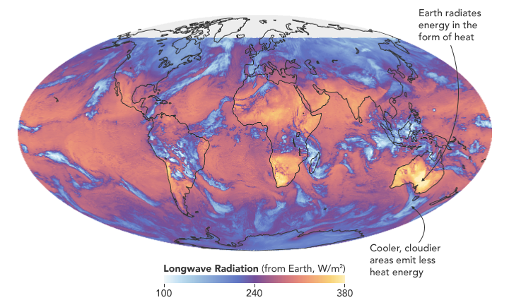
“It’s likely a mix of anthropogenic forcing and internal variability,” said Loeb. “And over this period they’re both causing warming, which leads to a fairly large change in Earth’s energy imbalance. The magnitude of the increase is unprecedented.”
Increases in emissions of greenhouse gases such as carbon dioxide and methane trap heat in the atmosphere, capturing outgoing radiation that would otherwise escape into space. The warming drives other changes, such as the melting of snow and ice, increased water vapor, and cloud changes that can further enhance the warming. Earth’s energy imbalance is the net effect of all these factors.
In order to determine the factors driving the imbalance, the investigators examined changes in clouds, water vapor, trace gases, the output of light from the Sun, Earth’s surface albedo (the amount of light reflected by the surface), atmospheric aerosols, and changes in surface and atmospheric temperature distributions.
The scientists found that the doubling of the energy imbalance is partially the result an increase in greenhouse gases from human activity, also known as anthropogenic forcing. It can also be attributed to increases in water vapor, which traps more outgoing longwave radiation and further contributes to Earth’s energy imbalance. The related decrease in clouds and sea ice also lead to more absorption of solar energy.
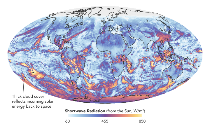
The authors also found that a flip of the Pacific Decadal Oscillation (PDO) from a cool phase to a warm phase likely played a major role in the intensification of the energy imbalance. The PDO is a pattern of Pacific climate variability in which a massive wedge of water in the eastern Pacific goes through cool and warm phases. This naturally occurring internal variability in the ocean can have far-reaching effects on weather and climate. An intensely warm PDO phase that began around 2014 and continued until 2020 caused a widespread reduction in cloud coverage over the ocean and a corresponding increase in the absorption of solar radiation.
“The lengthening and highly complementary records from Argo and CERES have allowed us both to pin down Earth’s energy imbalance with increasing accuracy, and to study its variations and trends with increasing insight, as time goes on,” said Gregory Johnson, co-author on the study and physical oceanographer at NOAA’s Pacific Marine Environmental Laboratory. “Observing the magnitude and variations of this energy imbalance are vital to understanding Earth’s changing climate.”
Loeb cautions that the study is only a snapshot relative to long-term climate change, and that it is not possible to predict with any certainty what the coming decades might look like for Earth’s energy budget. The study does conclude, however, that unless the rate of heat uptake subsides, greater changes in climate should be expected.

Every month on Earth Matters, we offer a puzzling satellite image. The February 2021 puzzler is above. Your challenge is to use the comments section to tell us what we are looking at, where it is, and why it is interesting.
How to answer. You can use a few words or several paragraphs. You might simply tell us the location, or you can dig deeper and explain what satellite and instrument produced the image, what spectral bands were used to create it, or what is compelling about some obscure feature. If you think something is interesting or noteworthy, tell us about it.
The prize. We cannot offer prize money or a trip to Mars, but we can promise you credit and glory. Well, maybe just credit. A few days after a puzzler image appears on this blog, we will post an annotated and captioned version as our Image of the Day. After we post the answer, we will acknowledge the first person to correctly identify the image at the bottom of this blog post. We also may recognize readers who offer the most interesting tidbits of information about the geological, meteorological, or human processes that have shaped the landscape. Please include your preferred name or alias with your comment. If you work for or attend an institution that you would like to recognize, please mention that as well.
Recent winners. If you’ve won the puzzler in the past few months, or if you work in geospatial imaging, please hold your answer for at least a day to give less experienced readers a chance.
Releasing Comments. Savvy readers have solved some puzzlers after a few minutes. To give more people a chance, we may wait 24 to 48 hours before posting comments. Good luck!
For more than 20 years, astronauts have been shooting photographs of Earth from the International Space Station. Before that, they looked down from Mercury, Gemini, Apollo, Skylab, the Space Shuttles, and MIR. They have brought us unique views of our home planet in all of its wonder, beauty, and ferocity. They have also made some interesting and timely science observations along the way.
More than 1,000 of those photos have been published here on NASA Earth Observatory. We would like you to help us choose the best in our archives. In early March, we will launch Tournament Earth: Astronaut Photography, and we want you to be part of the selection committee.
From now through February 19, 2021, search our archives and point out the best photos shot by the astronauts. Post the URLs of your favorite photos in the comments section below.
Please choose images from these collections:
EO Astronaut Photography Collection
Visible Earth: Astronaut Photography
Please note that there are 30+ pages of images to scroll through — an internet rabbit hole of incredible beauty.
In March 2021, we will include some of your selections in Tournament Earth, a head-to-head contest to vote for the best of the best from our archives. Each week, readers will pick from pairs of images as we narrow down the field from 32 nominees to one champion. The Tournament Earth champion will be announced in early April.
So get browsing and get choosing. Then post your favorite URLs in the comments section by February 19.
If you want to learn more about how and why astronauts shoot photos of our planet — and the special training involved — check out our video series “Picturing Earth.”
Astronaut Photography in Focus

Every month on Earth Matters, we offer a puzzling satellite image. The November 2020 puzzler is above. Your challenge is to use the comments section to tell us what we are looking at, where it is, and why it is interesting.
How to answer. You can use a few words or several paragraphs. You might simply tell us the location, or you can dig deeper and explain what satellite and instrument produced the image, what spectral bands were used to create it, or what is compelling about some obscure feature. If you think something is interesting or noteworthy, tell us about it.
The prize. We cannot offer prize money or a trip to Mars, but we can promise you credit and glory. Well, maybe just credit. A few days after a puzzler image appears on this blog, we will post an annotated and captioned version as our Image of the Day. After we post the answer, we will acknowledge the first person to correctly identify the image at the bottom of this blog post. We also may recognize readers who offer the most interesting tidbits of information about the geological, meteorological, or human processes that have shaped the landscape. Please include your preferred name or alias with your comment. If you work for or attend an institution that you would like to recognize, please mention that as well.
Recent winners. If you’ve won the puzzler in the past few months, or if you work in geospatial imaging, please hold your answer for at least a day to give less experienced readers a chance.
Releasing Comments. Savvy readers have solved some puzzlers after a few minutes. To give more people a chance, we may wait 24 to 48 hours before posting comments. Good luck!
UPDATE on November 9 — The answer is a phytoplankton bloom near the Jason Islands, an archipelago off of the Falkland (Malvinas) Islands. Read more about it here. Evzen Schulc quickly identified that it was an ocean bloom, though no one managed to identify the location.
To counter the rapid spread of COVID-19 in the winter and spring of 2020, quarantines and social distancing measures were implemented around the world. Air traffic nearly ceased; non-essential businesses were closed; and the number of vehicles on the road fell well below normal.
Remote sensing scientists have started looking at potential changes in the environment due to these changes in human behavior. They are looking for signs of how environmental factors such as humidity, temperature, and ultraviolet radiation might play a role in the behavior of the virus. Some may also look for data related to access to water resources, which can be critical to the spread or prevention of certain diseases.
NASA’s Earth Science Data Systems program has developed a new web-based tool, the COVID-19 Data Pathfinder, which provides links to datasets that can be used to research changing environmental impacts from modified human behavior patterns, the possibility of seasonal trends in virus transmission, and water availability. The COVID-19 Data Pathfinder is also a resource for participants in NASA’s Space Apps COVID-19 Challenge, providing an intuitive means for new users to find and use NASA data.
Web view of the COVID-19 Data Pathfinder page
There have been two rounds of voting in Tournament Earth 2020, and two rounds of stunning upsets. Only two of the top eight seeds made it through. Night Lights? Snuffed out. Colorado River? Dried up. Caspian ice? Melted. Aerosols? Cleaned out. A river of tea? Gone cold. Dark side of the Moon? Someone broke the record. Iconic Earthrise? Didn’t make it to dawn.
Every time we run one of these tournaments, we are surprised by what catches the eyes of our readers. It is time to surprise us again. Cast your votes now in round three to pick the best four of the Earthly 8. Voting ends on April 13 at 9 a.m. U.S. Eastern Time. Check out the remaining competitors below.

In round 1, Ocean Sand garnered the most votes overall and wiped out #4 seed and 2014 champion El Hierro Submarine Eruption, winning by the largest margin of any pairing (81 to 19 percent). In round 2, Sand beat the #1 seed, The Dark Side and the Bright Side, by a 57 to 43 percent margin.
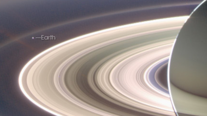
A View from Saturn garnered the second highest vote total in round 1, besting Blooming Baltic Sea by 77 to 23 percent. In the second round, Saturn beat Sensing Lightning from the Space Station, 60 to 40 percent. In case you didn’t notice, Earth is visible in that Saturn image.
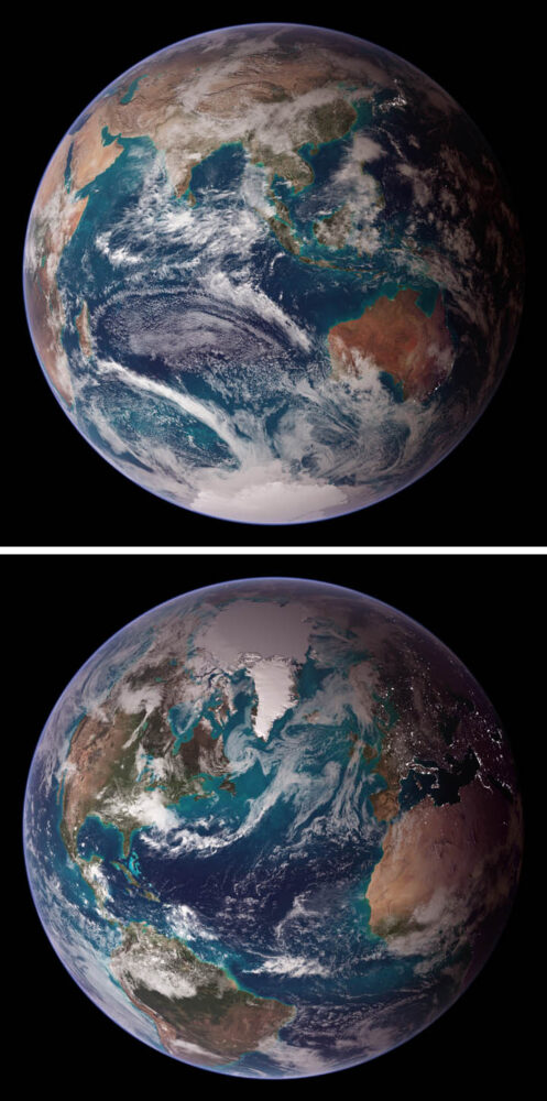
Twin Blue Marbles is the only #1 seed left in the tournament. In round 1, it captured 71 percent of the vote while besting Auroras Light Up the Antarctic Night. In round 2, Blue Marbles was the top overall vote getter and beat the iconic A Voyager Far from Home by 66 to 34 percent.
Fire in the Sky and On the Ground has pulled off two massive upsets. In round 1, it beat #2 seed Night Light Maps Open Up New Applications, 71 to 29 percent. In round 2, Fire beat the sentimental favorite and oldest image in Tournament Earth, All of You on the Good Earth — the original Blue Marble photo (1968) and the inspiration for the first Earth Day (1970). The voters chose the auroral fire over Apollo 8 fame by 57 to 43 percent.
This bracket pairs two low seeds that knocked off highly ranked opponents. #8 seed Where the Dunes End topped #1 A Curious Ensemble of Wonderful Features in round 1 (63 to 37 percent), then topped #4 Roiling Flows on Holuhraun Lava Field (56 to 44).
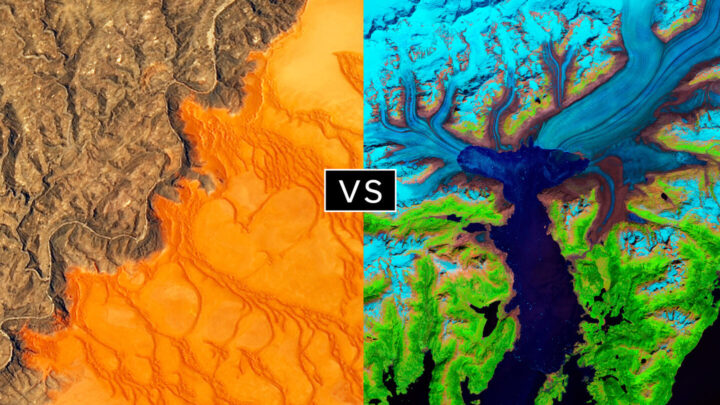
The false-color image Retreat of the Columbia Glacier got 57 percent of the vote to beat Icy Art in the Sanikov Strait in round 1. Round 2 was a close call: Columbia barely eclipsed Antartica Melts Under the Hottest Days on Record (51 to 49 percent).
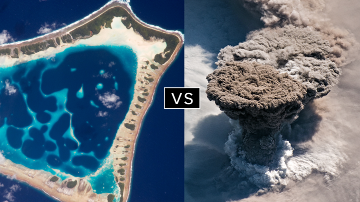
Another pair of Cinderella stories here. Atafu Atoll outclassed #1 seed Some Tea with Your River in round 1 by 75 to 25 percent. In round 2, it collected the second most votes overall, beating #5 Making Waves in the Andaman Sea 62 to 38 percent.
Raikoke erupted in round 1, collecting 72 percent of the vote while beating #3 Awesome, Frightening View of Hurricane Florence. In round 2, the volcanic plume smothered #2 Just Another Day on Aerosol Earth, 61 to 39 percent.

It has been a tough month on Earth. Good news has been scarce. But here’s at least one update ― from one million miles away ― to appreciate.
The Deep Space Climate Observatory (DSCOVR) satellite, which had been out of commission for about nine months due to a technical problem, is fully operational again, according to NOAA. Issues with the satellite’s attitude control system prompted engineers to put the satellite into a “safe hold” in June 2019, but they recently developed a software fix for the problem.
And that means that the satellite’s Earth Polychromatic Imaging Camera (EPIC) is once again taking beautiful full-disk images of our home several times each day. NASA’s EPIC instrument acquired the image of Africa and Europe (above) on March 19, 2020.
Head over to the science team page for EPIC and take a few moments to savor some imagery of our ever-changing planet. If Twitter is more your style, check out @DSCOVRDaily. Look carefully and you’ll see clouds and storm fronts coming and going, plumes of dust or smoke rising and fading, and whole continents greening and browning as the seasons change.
The EPIC view is a potent reminder of something that Frank White, author of The Overview Effect, said recently on a NASA podcast. (The book explores how seeing Earth from space causes many astronauts to dramatically change their outlook on our planet and life itself.)
“[One of the] conclusions they draw is that we are really all in this together,” he said. “Our fate is bound up with people that we may think are really different from [us]. We may have different religions, we may have different politics. But ultimately, we are connected. Totally connected.”
Since its launch on the web in April 1999, NASA Earth Observatory has published more than 15,500 image-driven stories about our planet. In celebration of our 20th anniversary — as well as the 50th anniversary of Earth Day — we want you to help us choose our all-time best image.
For now, we need you to help us brainstorm: what images or stories would you nominate as the best in the Earth Observatory collection? Do you go for the most beautiful and iconic view of our home? the most newsworthy? the most scientifically important? the most inspiring?
Search our site and then post the URLs of your favorite Earth images in the comments section below. Please send your ideas by March 17.

In late March 2020, we will include some of your selections in Tournament Earth, a head-to-head contest to vote for the best of the best from our archives. Each week, readers will pick from pairs of images as we narrow down the field from 32 nominees to one champion.
The all-time best Earth Observatory image will be announced on April 29, 2020, the end of our anniversary year.
If you want some inspiration as you begin your search, take a look at the galleries listed below. Or use our search tool (top left) to find your favorite places, images, and events.
NASA was mostly shut down for January 2019, but Earth wasn’t. In case you missed it, here are some of the big stories we didn’t cover during the impasse.
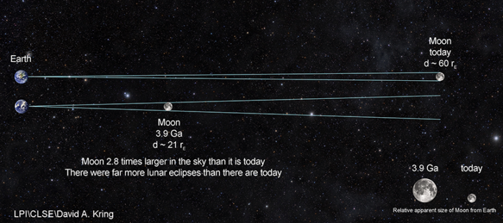
Scientists Find Evidence of An Ancient Earth Rock on the Moon
Four billion years ago, the Moon was about three times closer to Earth than it is now. So if a large asteroid or comet slammed into Earth and jettisoned material into space, it was more likely that rock fragments might end up landing on the Moon. That’s how an international team of scientists working with the Center for Lunar Science and Exploration (CLSE) think that a small fragment composed of quartz, feldspar, and zircon—a combination of minerals commonly found on Earth—ended up embedded within a larger Moon rock collected by Apollo astronauts. The team recently revealed evidence from the ancient rock fragment, suggesting that it is one of the oldest Earth rocks ever found.
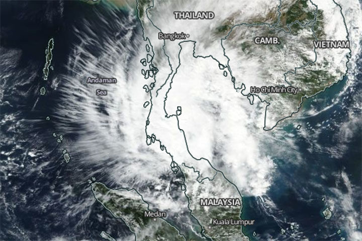
A Rare Typhoon Hits Thailand
It is rare for powerful tropical storms to strike Thailand. Before January 2019, the last time it happened was 1962. So meteorologists took notice when Tropical Storm Pabuk slammed into southern Thailand on January 4, 2019, packing sustained winds of 95 kilometers per hour (60 mph) and delivering torrential rains to some of Thailand’s most popular tourist destinations. The Moderate Resolution Imaging Spectroradiometer (MODIS) on NASA’s Aqua satellite captured this image of the storm on January 4, 2019.
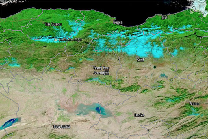
Snow Falls in Algeria (Yes, the Sahara)
In another unusual weather event, fresh snow created surreal scenery in Algeria when it coated Saharan desert dunes in mid-January. This is just the third time snow has fallen in Ain Sefra, the gateway to the Sahara Desert, in the past 37 years. (The last time was 2018.) The Moderate Resolution Imaging Spectroradiometer (MODIS) on NASA’s Terra satellite captured an image of the snow on January 14, 2019. It is composed with false color, using a combination of infraed and visible light (MODIS bands 7-2-1). Snow appears blue with this band combination.
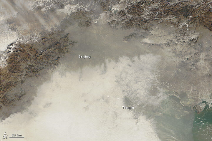
China’s War on Particulates May Be Making Ozone Pollution Worse
For the past few years, China has advanced an ambitious plan to reduce emissions of fine particulate (PM2.5), a harmful type of air pollution. Authorities have restricted the number of vehicles on the roads, capped how much coal industries can burn, and shuttered many polluting factories and power plants. The result has been impressive: over five years, concentrations of PM2.5 in eastern China have fallen nearly 40 percent. But, there is another wrinkle. Particulates also sponge up substances that make it harder for ground-level ozone to form. So even as concentrations of PM2.5 decline, ozone concentrations are rising, new research shows.
Can Satellites Sense Poverty?
Increasingly, yes, at least in rural areas. By analyzing observations of villages in Kenya, one team of researchers recently showed that land use and land cover data from satellites contains some useful clues for identifying the poorest households in rural areas. Key indicators included: the size of buildings within a homestead, the amount of bare agricultural land adjacent to a homestead, and the length of the growing season. The researchers think this type of information could make it easier to monitor the progress of efforts designed to reduce poverty in rural areas, such as the U.N. Sustainable Development Goals.

