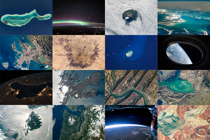
It is that time of year again…Tournament Earth is back! This time, the theme is astronaut photography. For more than 20 years, astronauts have been shooting stunning photos of Earth from the International Space Station that highlight the planet’s beauty, complexity, and vulnerabilities.
So which are the most unforgettable photographs of Earth taken from the space station? Over the next five weeks (March 8-April 13), you can help decide.
The first round has already begun. Cast your vote here: https://earthobservatory.nasa.gov/te
While you wait for the Round 1 results, download the bracket here and challenge your friends. After you fill out that bracket, post your predictions in the comment thread for which four photos will make the semifinals and which one will be crowned champion. We can’t offer prize money or a trip to the Moon, but bragging rights are forever if you can guess the eventual champion.
Also, bookmark this space. We will provide updates later in the tournament and highlight some of your predictions, commentary, and insights lower in the post. Just remember to use the hashtag #TournamentEarth and tag @NASAEarth on social media (we’re on Twitter, Facebook and Instagram) or we might not see your post.
If you are curious about the team behind the photos you see in Tournament Earth, check out our Picturing Earth video series.
Happy voting!
For more than 20 years, astronauts have been shooting photographs of Earth from the International Space Station. Before that, they looked down from Mercury, Gemini, Apollo, Skylab, the Space Shuttles, and MIR. They have brought us unique views of our home planet in all of its wonder, beauty, and ferocity. They have also made some interesting and timely science observations along the way.
More than 1,000 of those photos have been published here on NASA Earth Observatory. We would like you to help us choose the best in our archives. In early March, we will launch Tournament Earth: Astronaut Photography, and we want you to be part of the selection committee.
From now through February 19, 2021, search our archives and point out the best photos shot by the astronauts. Post the URLs of your favorite photos in the comments section below.
Please choose images from these collections:
EO Astronaut Photography Collection
Visible Earth: Astronaut Photography
Please note that there are 30+ pages of images to scroll through — an internet rabbit hole of incredible beauty.
In March 2021, we will include some of your selections in Tournament Earth, a head-to-head contest to vote for the best of the best from our archives. Each week, readers will pick from pairs of images as we narrow down the field from 32 nominees to one champion. The Tournament Earth champion will be announced in early April.
So get browsing and get choosing. Then post your favorite URLs in the comments section by February 19.
If you want to learn more about how and why astronauts shoot photos of our planet — and the special training involved — check out our video series “Picturing Earth.”
Astronaut Photography in Focus
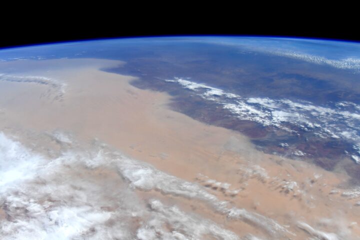
Baked by heat and drought, deluged by rain and floods, scorched by wildfire, and blanketed by dust, Australia has faced several months of extreme weather.
Some of the latest jaw-dropping images come from NASA astronaut Christina Koch. “Australia. Our hearts and thoughts are with you,” she tweeted, along with images of a massive dust storm making its way across the continent and smoke streaming from bushfires in southeastern Australia.
Meanwhile, Jean-Paul Vernier, a senior scientist at the National Institute of Aerospace at NASA Langley Research Center and the lead of a NASA disasters team responding to the fires, has been using data from the CALIPSO satellite to measure something impossible to discern from an aerial photograph, even one taken from space—the height of the smoke. As we reported earlier, the fires are so intense that they have lifted smoke all the way to the stratosphere, something wildfires do only occasionally. (Usually, volcanoes lift plumes to such heights.)
On January 6, 2020, the smoke had reached 19 kilometers (12 miles). Interestingly, it kept rising. By January 13, it was up to 21 kilometers.
“The radiative heating from the soot particles within the smoke makes wildfire plumes particularly buoyant, meaning they will reach higher altitudes in the stratosphere and stay there longer than material from a volcanic eruption that reaches the same initial altitude,” Vernier explained.
If you are like me, you have probably fantasized about looking down and photographing Earth while floating in the zero gravity of space.
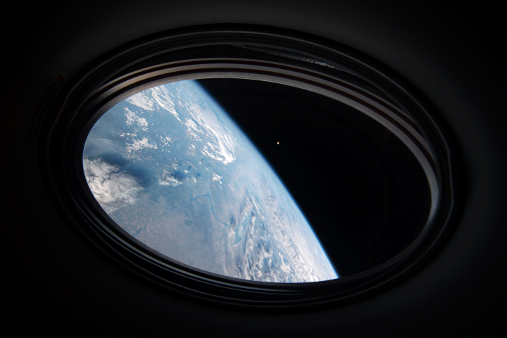
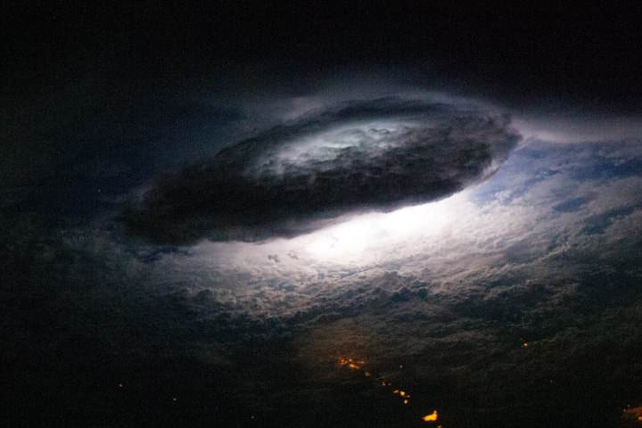
I suppose I should never say never, but my chances of becoming an astronaut do look pretty slim at this point in my life. But even if I can’t experience space firsthand, I may have have found the next best thing: merged panorama photographs that make me feel like I am up there. NASA astronaut Jeff Williams has been posting short video clips on his social media feeds and the results are stunning.
All of these panoramas were taken while he was orbiting about 250 miles (400 kilometers) above the surface of Earth on the International Space Station. At the time, he was moving about 17,150 miles (27,600 kilometers) per hour. The photos were taken from the Cupola, a dome-shaped module on the Space Station with bay windows that offer panoramic views of Earth. To make the videos, Williams (with help from NASA colleagues on the ground) stitched together several images into mosaics and then used computer software to pan across the mosaic.
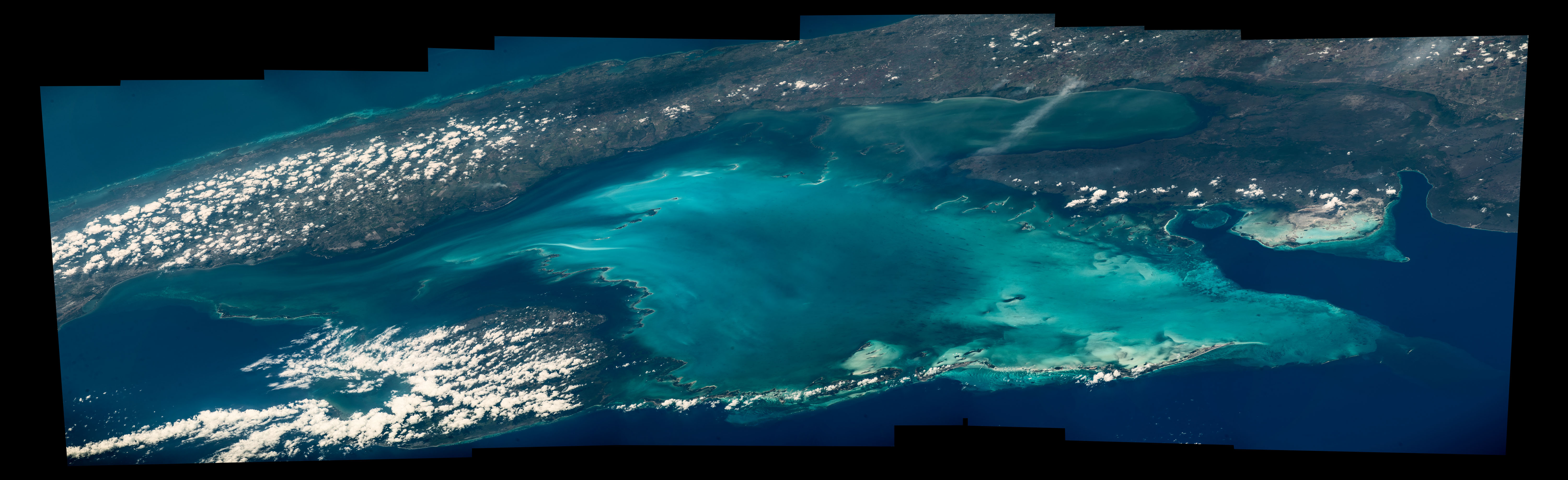
I have posted a few of my favorites here: a sunset, the coastline of western Australia, the Andes Mountains, and Cuba’s Gulf of Batabano. Scroll down past the video for a view of one of the raw mosaics and some video of Williams explaining what it is like to take photographs from space. Browse more astronaut photography here and find more of Williams’ photography on Facebook, Twitter, and Instagram. In related stories from the Earth Observatory, learn more about sunsets seen from space, the Andes, and coastal Australia.
Here is how the raw mosaic of the Gulf of Batabano looked.

And here is Williams explaining the cameras he uses and how he makes the merged panoramas.

On March 1, 2016, NASA astronaut Scott Kelly returned to Earth after spending 340 days living continuously in space. That’s a record. No other American astronaut has completed a longer mission or spent more cumulative days in space.
A prolific and talented photographer, Kelly posted hundreds and hundreds of photographs of the Earth below to social media during his flight. In a fitting finale for the record-breaking explorer, one of the last photos he posted from orbit was this hazy blue scene of the Himalayas.
“The Himalayas remind me of the bigger view we see when we conquer the mountains we climb,” he said on Twitter. The tip of mountain Mount Everest is about 8.8 kilometers (5.5 miles) above sea level; Kelly was in orbit about 250 kilometers above sea level. Over the course of the mission, he traveled some 231,498,541 kilometers.
Congratulations, Scott, on your safe return. Thank you for the beautiful photos. And keep climbing. (The image below, an astronaut photograph taken in 2013, shows K2, one the most treacherous mountains in the world for climbers. Read more about the 8K peaks here.)

Photographs by Scott Kelly/NASA. Sunrise (upper); sunset (lower).
My colleagues and I spend most of our time looking for stories, images, and data related to the latest and greatest remote sensing science at NASA and beyond. This often leads us to rather technical scientific journals and obscure websites that are hardly known for their artistry.
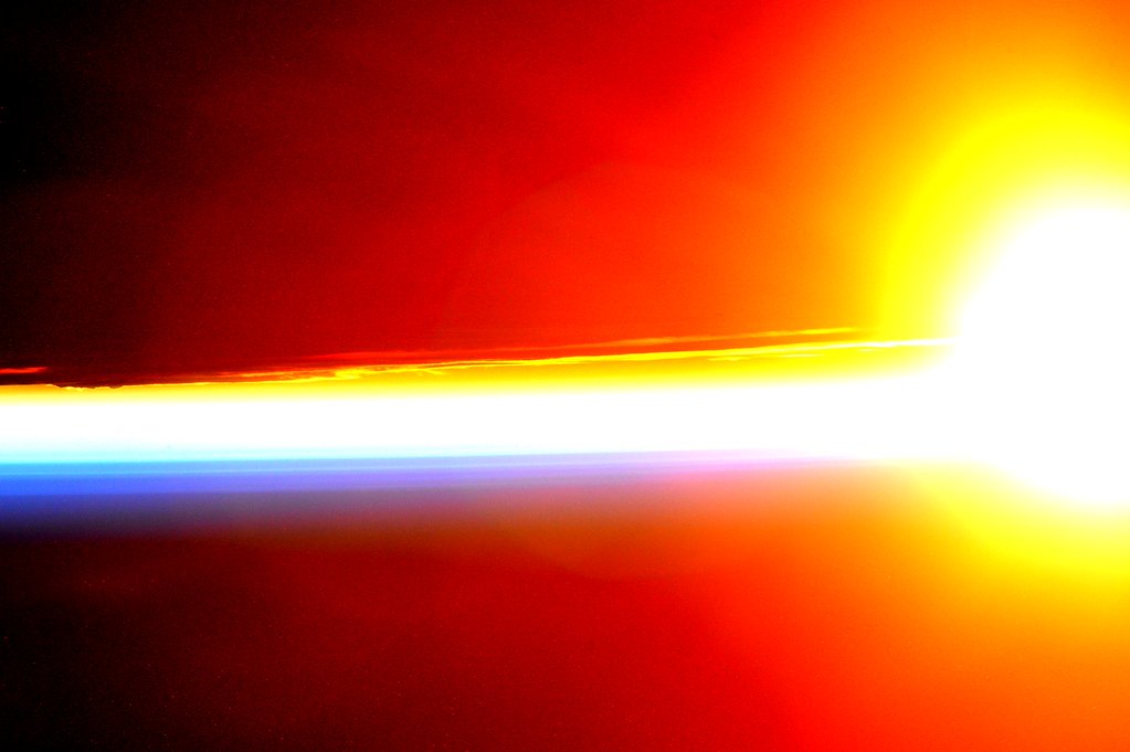
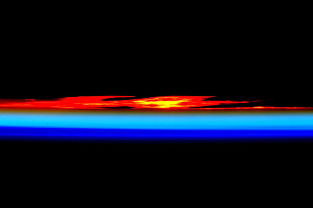
But every now and then during the course of a workday, we stumble across an image that is simply so gorgeous that we can not resist sharing it. The first image above, tweeted from the International Space Station by astronaut Scott Kelly on January 13, captures the intense, raw beauty of a sunrise with an unforgettable gradient of yellow to red. About eight hours later, he tweeted the second image. “Day 292. Colors of #sunset. #GoodNight from @space_station! #YearInSpace,” Kelly said of the orange, teal, and blue horizontal lines that fade to black.
This was probably not Kelly’s only chance to capture a spectacular sunset and sunrise on January 13.
“The sun truly ‘comes up like thunder,’ and it sets just as fast,” said Joseph Allen, an astronaut who logged more than 300 hours in space on the Space Shuttle in the 1980s. “Each sunrise and sunset lasts only a few seconds. But in that time you see at least eight different bands of color come and go, from a brilliant red to the brightest and deepest blue.”
Curious to see more sunsets and sunrises from space? In the image below, see how a sunset reveals different layers of the atmosphere. Learn more about the image here. See several more of Kelly’s sunrise and sunset photographs featured by The Atlantic here. And if you still want more space sunrises and sunsets, check out our archives.

The answer to the August puzzler — Nagoya and the south-central coast of Japan — was puzzling even to Earth Observatory staff.

When we first posted the image on August 26, even we did not know what we were looking at. We had asked our colleagues at the Crew Earth Observations (CEO) office at NASA Johnson Space Center to give us an image that would stump our readers and would help us talk about a new citizen science project to identify the locations shown in nighttime images. They gave us an image that no one here immediately recognized.
In the process of presenting the answer last Friday (image below), we unwittingly demonstrated a quality-control portion of that ID program.

As you can see, we correctly labeled Nagoya, and then labeled the two cities on the left as Osaka and Wakayama. But as several readers from Japan pointed out, Osaka and Wakayama are farther west, and Kyoto also appears in the scene. Though we had consulted two different sources, maps of Earth at night are still pretty raw and the human eye can be tricked when looking at an unfamiliar landscape.
One of the protocols of the Cities at Night program is to ensure that every image is classified by multiple individuals working separately. It took several NASA staff and several readers to figure out the correct locations in this image. One of the goals of the citizen-science project is to figure out the optimal number of people needed to correctly classify an image. We didn’t intend to be a case study, but that’s what just happened.
Congratulations to Bruce Boucek, a data librarian at Brown University, for being the first reader to correctly identify Nagoya and the Chita peninsula of Japan. We asked him how he figured out the location, and he wrote: “I’ve been a map fanatic since I was a kid…When I was an undergrad, I had a particular interest in Japanese geography and as a PhD student I spent years working with remote sensing and satellite imagery. My initial hunch was that it was the eastern coast of Japan, but it didn’t look like Tokyo. I guessed that it was the next bay south and verified my hunch by looking at the NASA earth at night imagery. The clincher was the airports which have a significantly higher brightness signature.”
Three other readers — James Titmas, Jyo Sano, and Yumiko Stettler — also correctly identified the Nagoya area. Thanks also to Justin Wilkinson, Will Stefanov, and the CEO unit at NASA Johnson, a team that has to catalog and identify the thousands of images that come down from the International Space Station every year.

Every month on Earth Matters, we offer a puzzling satellite image. The August 2014 puzzler is above. Your challenge is to use the comments section to tell us what part of the world we are looking at, when the image was acquired, what the image shows, and why the scene is interesting.
How to answer. Your answer can be a few words or several paragraphs. (Try to keep it shorter than 200 words). You might simply tell us what part of the world an image shows. Or you can dig deeper and explain what satellite and instrument produced the image, what spectral bands were used to create it, or what is compelling about some obscure speck in the far corner of an image. If you think something is interesting or noteworthy, tell us about it.
The prize. We can’t offer prize money, but, we can promise you credit and glory (well, maybe just credit). Roughly one week after a puzzler image appears on this blog, we will post an annotated and captioned version as our Image of the Day. In the credits, we’ll acknowledge the person who was first to correctly ID the image. We’ll also recognize people who offer the most interesting tidbits of information about the geological, meteorological, or human processes that have played a role in molding the landscape. Please include your preferred name or alias with your comment. If you work for or attend an institution that you want us to recognize, please mention that as well.
Recent winners. If you’ve won the puzzler in the last few months or work in geospatial imaging, please sit on your hands for at least a day to give others a chance to play.
Releasing Comments. Savvy readers have solved some of our puzzlers after only a few minutes or hours. To give more people a chance to play, we may wait between 24-48 hours before posting the answers we receive in the comment thread.
UPDATE (September 4) – The answer to this puzzler was the Image of the Day on August 31. We also posted a blog entry about the challenges in solving this puzzler.
Since he rocketed to the International Space Station (ISS) on May 29, 2014, American astronaut Reid Wiseman has been enjoying the sights. He has built an active following on Twitter by sharing photographs of a world he is seeing from space for the first time. Like many first-timers in space, he is also discovering some curiosities that most of us never see from the ground.
On August 18, he tweeted the following photo and comment: “Bangkok is the bright city. The green lights outside the city? No idea…”

Astute Twitter followers, journalists, and bloggers quickly pointed out that @astro_reid was most likely seeing fishing boats, which use bright lamps to draw plankton, squid, and fish to the surface. Several people even pointed to the Earth Observatory and our story about mysterious night lights off the coast of South America. It turns out that Wiseman’s fisherman also appear in the first three seconds of this time-lapse video shot from the ISS as it flew over eastern Asia in January 2014.
A few weeks ago, Wiseman had a similar experience looking out over Taiwan and the coast of China. “Could all those white lights off the coast of Taiwan be fishing boats? Hard to believe.”

Maybe Wiseman will spot some other strange lights, such as the mystery lights of the Australian Outback…the natural gas flares of the Dakotas…the contrail of a rocket…or gamma-ray rich lightning. The natural sights of the planet at night are far more compelling that any UFO stories.
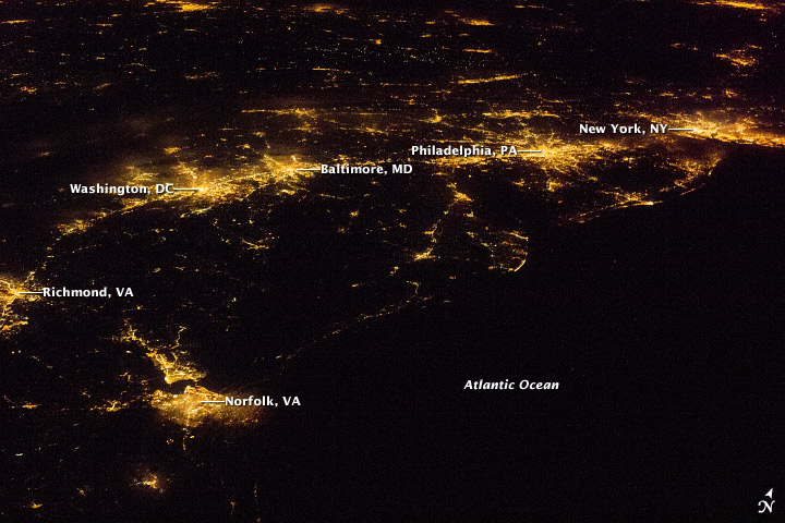
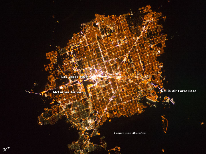
Over four missions, astronaut Carl Walz logged 231 days in space. Before the launch of the International Space Station resupply Orb-2 mission from Wallops Island, Virginia, in July 2014, he described a few of views of Earth from space that he remembers best. Walz is now Vice President of Human Space Flight Operations at Orbital, a Virginia-based aerospace company.
“There was one rare, clear night that sticks out in my memory when I could see all the city lights along the Eastern Seaboard. I’ll never forget those lights. I could see New York, Philadelphia, Washington, all the way west to Chicago all at once. It was just all there…
…and there was absolutely nothing like flying over Las Vegas at night. You can actually see the colors of the lights. Most city lights are a kind of white light that’s a bit diffuse. Then there’s Las Vegas. It’s this bright spot out in the middle of the desert just staring you in the face…
…And the storms. We didn’t see any hurricanes because we were flying in the winter and springtime in the Northern Hemisphere, but we did see our share of thunderstorms. Remember, you’re looking at the thunderstorms from the top down. You can’t see lightning directly, but you can see these incredible flashes illuminating the clouds…
…Oh, of course, we’d sometimes see shooting stars. From that perspective, it was simply jaw-dropping.”

Editor’s Note: The photographs used to illustrate this post were not taken by Walz. Click on each of image to find out more about when it was taken. To see more astronaut photographs, check the Earth Observatory Image of the Day on Mondays, browse the archive of astronaut photographs on Visible Earth, or search the Gateway to Astronaut Photography website.

