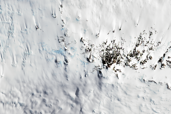
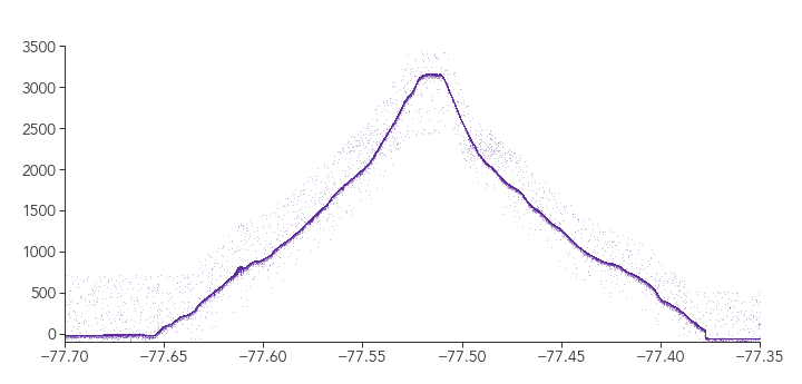
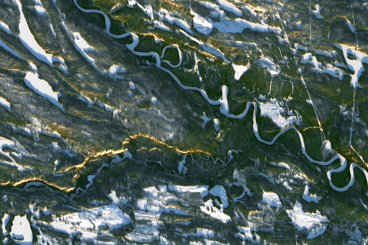
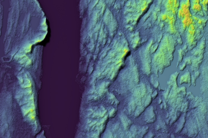
Update on December 12, 2022: This puzzler image shows Mount Terror, a shield volcano located on the eastern side of Ross Island, Antarctica. Congratulations to Garrett Layne, the first person to correctly identify the mountain, its location, and the elevation profile. Special mention goes to Joe Cornelius, who used the elevation profile to identify candidate islands and arrived at the correct answer. Read more about Mount Terror in the Image of the Day.
Every month on Earth Matters, we offer a puzzling satellite image. The October 2022 puzzler is shown above. Your challenge is to use the comments section to tell us where it is, what we are looking at, and why it is interesting. This month, special mention will go to those who can also describe what the visualization below the image is showing.
How to answer. You can use a few words or several paragraphs. You might simply tell us the location, or you can dig deeper and offer details about what satellite and instrument produced the image, what spectral bands were used to create it, or what is compelling about some obscure feature. If you think something is interesting or noteworthy, tell us about it.
The prize. We cannot offer prize money or a trip on the International Space Station, but we can promise you credit and glory. Well, maybe just credit. Within a week after a puzzler image appears on this blog, we will post an annotated and captioned version as our Image of the Day. After we post the answer, we will acknowledge the first person to correctly identify the image at the bottom of this blog post. We also may recognize readers who offer the most interesting tidbits of information. Please include your preferred name or alias with your comment. If you work for or attend an institution that you would like to recognize, please mention that as well.
Recent winners. If you have won the puzzler in the past few months, or if you work in geospatial imaging, please hold your answer for at least a day to give less experienced readers a chance.
Releasing Comments. Savvy readers have solved some puzzlers after a few minutes. To give more people a chance, we may wait 24 to 48 hours before posting comments. Good luck!
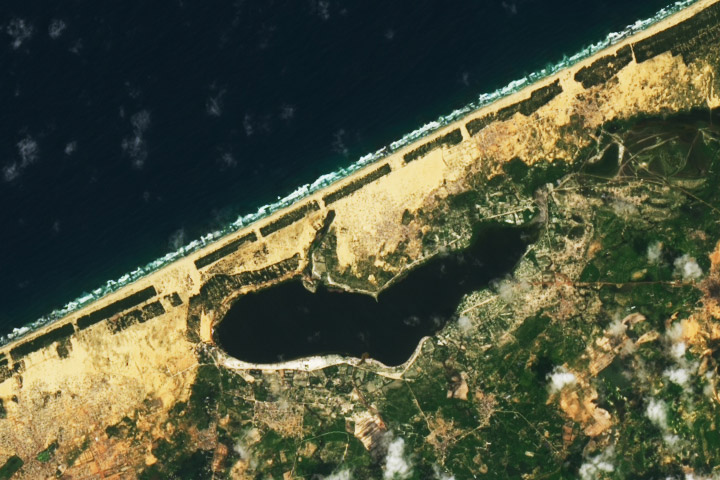
Update on October 26, 2022: This puzzler image shows Lake Retba along the coast of Senegal. The lake’s water’s are often rosy, but had darkened by the time this image was acquired in September 2022 after bouts of heavy rainfall and flooding. Congratulations to Keith Trinity, who was the first to correctly identify the lake and its location. Special mention goes to Rakhee Ranjan for pointing out the intense monsoon season in 2022 and other facts about the region. Read more in the related Image of the Day.
Every month on Earth Matters, we offer a puzzling satellite image. The September 2022 puzzler is shown above. Your challenge is to use the comments section to tell us where it is, what we are looking at, and why it is interesting.
How to answer. You can use a few words or several paragraphs. You might simply tell us the location, or you can dig deeper and offer details about what satellite and instrument produced the image, what spectral bands were used to create it, or what is compelling about some obscure feature. If you think something is interesting or noteworthy, tell us about it.
The prize. We cannot offer prize money or a trip on the International Space Station, but we can promise you credit and glory. Well, maybe just credit. Within a week after a puzzler image appears on this blog, we will post an annotated and captioned version as our Image of the Day. After we post the answer, we will acknowledge the first person to correctly identify the image at the bottom of this blog post. We also may recognize readers who offer the most interesting tidbits of information. Please include your preferred name or alias with your comment. If you work for or attend an institution that you would like to recognize, please mention that as well.
Recent winners. If you have won the puzzler in the past few months, or if you work in geospatial imaging, please hold your answer for at least a day to give less experienced readers a chance.
Releasing Comments. Savvy readers have solved some puzzlers after a few minutes. To give more people a chance, we may wait 24 to 48 hours before posting comments. Good luck!
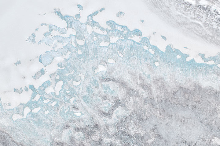
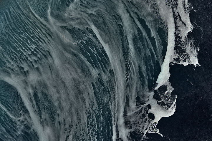
Update on August 5, 2022: This puzzler image shows a portion of Nordaustlandet—a large island in northeast Svalbard. The image was acquired after a record amount of melting took place across the Norwegian archipelago in summer 2022. Notice the extensive light-blue areas where snow and firn have melted away and exposed bare ice (light blue). Congratulations to Yoshihiro Nakayama, who correctly identified the location. Special mention goes to Soren J and others for pointing features associated with melting. Read more in the related Image of the Day.
Every month on Earth Matters, we offer a puzzling satellite image. The August 2022 puzzler is shown above. Your challenge is to use the comments section to tell us where it is, what we are looking at, and why it is interesting.
How to answer. You can use a few words or several paragraphs. You might simply tell us the location, or you can dig deeper and offer details about what satellite and instrument produced the image, what spectral bands were used to create it, or what is compelling about some obscure feature. If you think something is interesting or noteworthy, tell us about it.
The prize. We cannot offer prize money or a trip on the International Space Station, but we can promise you credit and glory. Well, maybe just credit. Within a week after a puzzler image appears on this blog, we will post an annotated and captioned version as our Image of the Day. After we post the answer, we will acknowledge the first person to correctly identify the image at the bottom of this blog post. We also may recognize readers who offer the most interesting tidbits of information. Please include your preferred name or alias with your comment. If you work for or attend an institution that you would like to recognize, please mention that as well.
Recent winners. If you have won the puzzler in the past few months, or if you work in geospatial imaging, please hold your answer for at least a day to give less experienced readers a chance.
Releasing Comments. Savvy readers have solved some puzzlers after a few minutes. To give more people a chance, we may wait 24 to 48 hours before posting comments. Good luck!
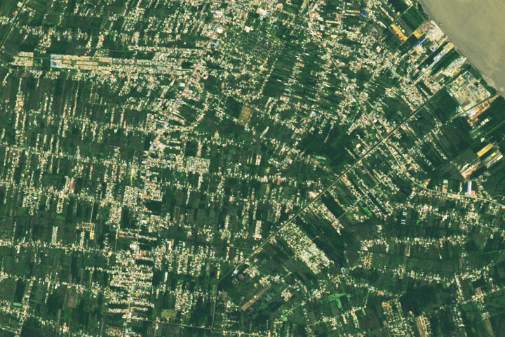
Update on June 28, 2022: Drumroll please…..?????? ….the answer is….PARAMARIBO, SURINAME. The natural-color image was acquired in June 2022 by the satellite’s Operational Land Imager on Landsat 8. Read more about Paramaribo in our June 27 Image of the Day. Congratulations to Firdous Khodabaks, Corey TM, and Nerdonna for being among the first readers to correctly identify the location. Thanks also for sharing interesting details about oil refining, recent flooding, and the presidential palace.
Every month on Earth Matters, we offer a puzzling satellite image. The June 2022 puzzler is shown above. Your challenge is to use the comments section to tell us where it is, what we are looking at, and why it is interesting.
How to answer. You can use a few words or several paragraphs. You might simply tell us the location, or you can dig deeper and offer details about what satellite and instrument produced the image, what spectral bands were used to create it, or what is compelling about some obscure feature. If you think something is interesting or noteworthy, tell us about it.
The prize. We cannot offer prize money or a trip on the International Space Station, but we can promise you credit and glory. Well, maybe just credit. Within a week after a puzzler image appears on this blog, we will post an annotated and captioned version as our Image of the Day. After we post the answer, we will acknowledge the first person to correctly identify the image at the bottom of this blog post. We also may recognize readers who offer the most interesting tidbits of information. Please include your preferred name or alias with your comment. If you work for or attend an institution that you would like to recognize, please mention that as well.
Recent winners. If you have won the puzzler in the past few months, or if you work in geospatial imaging, please hold your answer for at least a day to give less experienced readers a chance.
Releasing Comments. Savvy readers have solved some puzzlers after a few minutes. To give more people a chance, we may wait 24 to 48 hours before posting comments. Good luck!
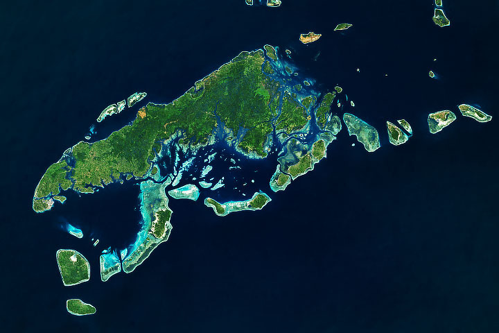
Update: A running hare. A jumping frog. A hungry dinosaur. Readers suggested that the arrangement of islands pictured here bears resemblance to such terrestrial creatures. But in this part of the southern Philippines, it is the aquatic life that sustains the livelihoods of many islanders. Read more about Tawi-Tawi in our April 23 Image of the Day. Congratulations to Reven Gibaga, Matthew Meyers, and Krzysztof Luszczki for being among the first readers to correctly identify the location. Thanks also for sharing your creative interpretations of the image.
Every month on Earth Matters, we offer a puzzling satellite image. The April 2022 puzzler is shown above. Your challenge this month has a new twist: In addition to telling us the location of the image, we invite you to get creative and tell us what you see.
How to answer. Using the comments section, tell us the image location and any features that stand out to you. Do you see an interesting resemblance, shape, or pattern? Share your ideas in a few words or several paragraphs. Note that responses will be vetted for appropriateness.
The prize. We cannot offer prize money or a trip on the International Space Station, but we can promise you credit and glory. Well, maybe just credit. Within a week after a puzzler image appears on this blog, we will post an annotated and captioned version as our Image of the Day. After we post the answer, we will acknowledge the first person to correctly identify the image. We will also highlight some of the most creative comments. Please include your preferred name or alias with your comment. If you work for or attend an institution that you would like to recognize, please mention that as well.
Recent winners. If you have won the puzzler in the past few months, or if you work in geospatial imaging, please hold your answer for at least a day to give less experienced readers a chance.
Releasing Comments. Savvy readers have solved some puzzlers after a few minutes. To give more people a chance, we may wait 24 to 48 hours before posting comments. Good luck!
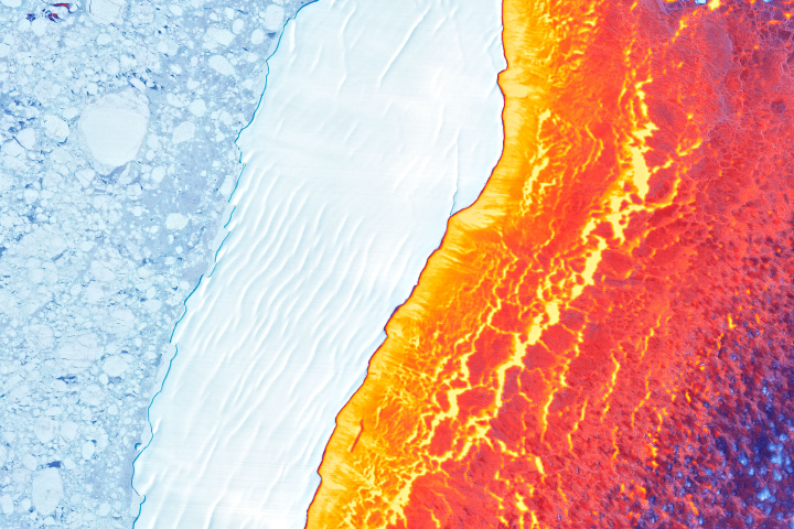
Update on March 22, 2022: This puzzler image shows Iceberg D-30A drifting amid sea ice in Antarctica’s Weddell Sea. The false-color image was created by blending data from the Landsat 8 satellite’s satellite’s Operational Land Imager (for detail and texture) and its Thermal Infrared Sensor (TIRS). The warmest areas (yellow, orange, and red) depict open water and thin, newly formed sea ice. The coldest areas (blue and white) are older, thicker ice, including the icebergs and broken ice rubble in their paths. Congratulations to Jan Lieser who correctly identified the iceberg and various sea ice types. Honorable mention goes to Sergio Vidal-Luengo and Veronica Zapata for correctly identifying the thermal component of the image. Read more in the related Image of the Day.
Every month on Earth Matters, we offer a puzzling satellite image. The March 2022 puzzler is shown above. Your challenge is to use the comments section to tell us where it is, what we are looking at, and why it is interesting.
How to answer. You can use a few words or several paragraphs. You might simply tell us the location, or you can dig deeper and offer details about what satellite and instrument produced the image, what spectral bands were used to create it, or what is compelling about some obscure feature. If you think something is interesting or noteworthy, tell us about it.
The prize. We cannot offer prize money or a trip on the International Space Station, but we can promise you credit and glory. Well, maybe just credit. Within a week after a puzzler image appears on this blog, we will post an annotated and captioned version as our Image of the Day. After we post the answer, we will acknowledge the first person to correctly identify the image at the bottom of this blog post. We also may recognize readers who offer the most interesting tidbits of information. Please include your preferred name or alias with your comment. If you work for or attend an institution that you would like to recognize, please mention that as well.
Recent winners. If you have won the puzzler in the past few months, or if you work in geospatial imaging, please hold your answer for at least a day to give less experienced readers a chance.
Releasing Comments. Savvy readers have solved some puzzlers after a few minutes. To give more people a chance, we may wait 24 to 48 hours before posting comments. Good luck!
Every month on Earth Matters, we offer a puzzling satellite image. The January 2022 puzzler is shown above. Your challenge is to use the comments section to tell us where it is, what we are looking at, and why it is interesting.
How to answer. You can use a few words or several paragraphs. You might simply tell us the location, or you can dig deeper and offer details about what satellite and instrument produced the image, what spectral bands were used to create it, or what is compelling about some obscure feature. If you think something is interesting or noteworthy, tell us about it.
The prize. We cannot offer prize money or a trip on the International Space Station, but we can promise you credit and glory. Well, maybe just credit. Within a week after a puzzler image appears on this blog, we will post an annotated and captioned version as our Image of the Day. After we post the answer, we will acknowledge the first person to correctly identify the image at the bottom of this blog post. We also may recognize readers who offer the most interesting tidbits of information. Please include your preferred name or alias with your comment. If you work for or attend an institution that you would like to recognize, please mention that as well.
Recent winners. If you have won the puzzler in the past few months, or if you work in geospatial imaging, please hold your answer for at least a day to give less experienced readers a chance.
Releasing Comments. Savvy readers have solved some puzzlers after a few minutes. To give more people a chance, we may wait 24 to 48 hours before posting comments. Good luck!
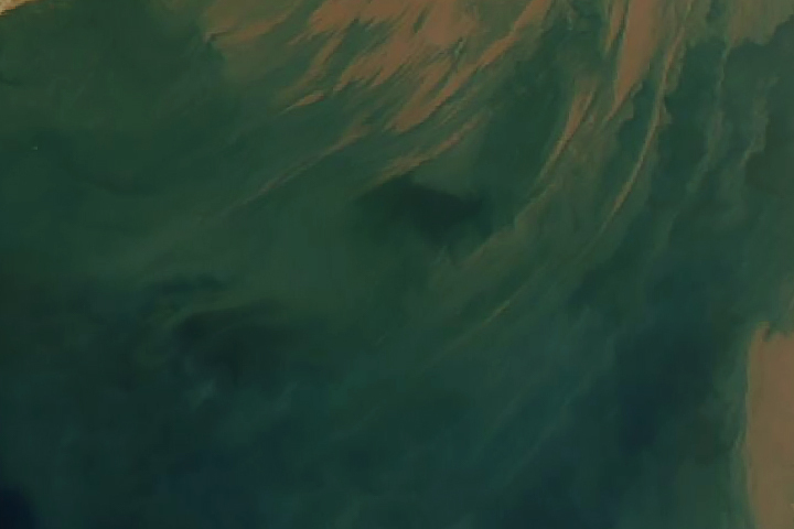
February 1 update: The answer is suspended sediment in the Gulf of Khambhat, off the northwest coast of India. Congratulations to K Suraj, who correctly identified the Gujarat region of India and the Arabian Sea coast. Read more in this Image of the Day.
Happy Solstice Day!
Every month on Earth Matters, we offer a puzzling satellite image. The December 2021 puzzler is shown above. Your challenge is to use the comments section to tell us where it is, what we are looking at, and why it is interesting. In particular this month, what is the golden line/streak across the image?
How to answer. You can use a few words or several paragraphs. You might simply tell us the location, or you can dig deeper and offer details about what satellite and instrument produced the image, what spectral bands were used to create it, or what is compelling about some obscure feature. If you think something is interesting or noteworthy, tell us about it.
The prize. We cannot offer prize money or a trip on the International Space Station, but we can promise you credit and glory. Well, maybe just credit. Within one week after a puzzler image appears on this blog, we will post an annotated and captioned version as our Image of the Day. After we post the answer, we will acknowledge the first person to correctly identify the image at the bottom of this blog post. We also may recognize readers who offer the most interesting tidbits of information. Please include your preferred name or alias with your comment. If you work for or attend an institution that you would like to recognize, please mention that as well.
Recent winners. If you’ve won the puzzler in the past few months, or if you work in geospatial imaging, please hold your answer for at least a day to give less experienced readers a chance.
Releasing Comments. Savvy readers have solved some puzzlers after a few minutes. To give more people a chance, we may wait 24 to 48 hours before posting comments. Good luck!
Update: The answer is the Sápmi region of Finland (formerly known as Lapland), not far from Oulanka National Park. You can read more here. Tom Franco correctly noted the low Sun angle (but it is not a sunset), while Frank correctly noted the proximity to the Arctic Circle.
Every month on Earth Matters, we offer a puzzling satellite image. The November 2021 puzzler is above. Your challenge is to use the comments section to tell us what we are looking at, where it is, and why it is interesting.
How to answer. You can use a few words or several paragraphs. You might simply tell us the location, or you can dig deeper and explain what satellite and instrument produced the image, what spectral bands were used to create it, or what is compelling about some obscure feature. If you think something is interesting or noteworthy, tell us about it.
The prize. We cannot offer prize money or a trip to Mars, but we can promise you credit and glory. Well, maybe just credit. Roughly one week after a puzzler image appears on this blog, we will post an annotated and captioned version as our Image of the Day. After we post the answer, we will acknowledge the first person to correctly identify the image at the bottom of this blog post. We also may recognize readers who offer the most interesting tidbits of information about the geological, meteorological, or human processes that have shaped the landscape. Please include your preferred name or alias with your comment. If you work for or attend an institution that you would like to recognize, please mention that as well.
Recent winners. If you’ve won the puzzler in the past few months, or if you work in geospatial imaging, please hold your answer for at least a day to give less experienced readers a chance.
Releasing Comments. Savvy readers have solved some puzzlers after a few minutes. To give more people a chance, we may wait 24 to 48 hours before posting comments. Good luck!
Update: The answer is sea ice in the Weddell Sea, off Antarctica’s Ronne Ice Shelf. Congratulations to Colin, who correctly identified the feature as sea ice, and to Katie Gerber who correctly identified the feature and location. Read more in this Image of the Day.
UPDATE — This image shows the terrain in Sleepy Hollow, New York, the setting for The Legend of Sleepy Hollow. See the full image and story in our October 31 Image of Image of the Day. Congratulations to Chris Pollard for being the first reader to solve the puzzler.
Every month on Earth Matters, we offer a puzzling satellite image. The October 2021 puzzler is above. Your challenge is to use the comments section to tell us what we are looking at, where it is, and why it is interesting.
How to answer. You can use a few words or several paragraphs. You might simply tell us the location, or you can dig deeper and explain what satellite and instrument produced the image, what spectral bands were used to create it, or what is compelling about some obscure feature. If you think something is interesting or noteworthy, tell us about it.
The prize. We cannot offer prize money or a trip to Mars, but we can promise you credit and glory. Well, maybe just credit. Roughly one week after a puzzler image appears on this blog, we will post an annotated and captioned version as our Image of the Day. After we post the answer, we will acknowledge the first person to correctly identify the image at the bottom of this blog post. We also may recognize readers who offer the most interesting tidbits of information about the geological, meteorological, or human processes that have shaped the landscape. Please include your preferred name or alias with your comment. If you work for or attend an institution that you would like to recognize, please mention that as well.
Recent winners. If you’ve won the puzzler in the past few months, or if you work in geospatial imaging, please hold your answer for at least a day to give less experienced readers a chance.
Releasing Comments. Savvy readers have solved some puzzlers after a few minutes. To give more people a chance, we may wait 24 to 48 hours before posting comments. Good luck!
