
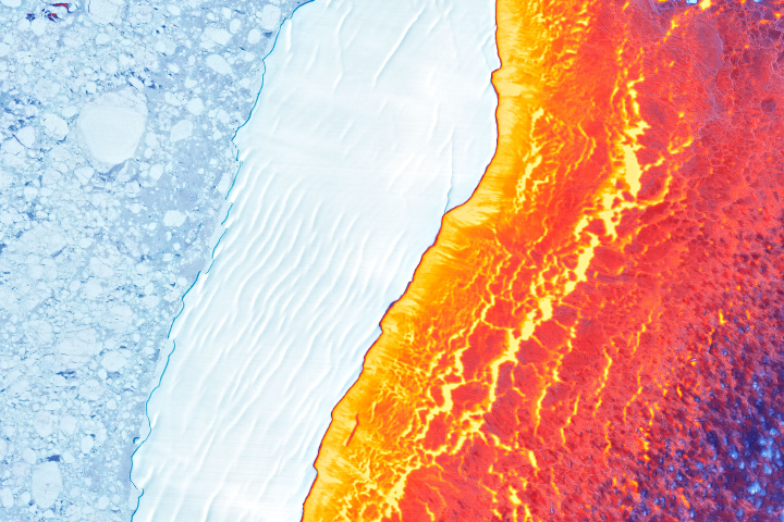
Update on March 22, 2022: This puzzler image shows Iceberg D-30A drifting amid sea ice in Antarctica’s Weddell Sea. The false-color image was created by blending data from the Landsat 8 satellite’s satellite’s Operational Land Imager (for detail and texture) and its Thermal Infrared Sensor (TIRS). The warmest areas (yellow, orange, and red) depict open water and thin, newly formed sea ice. The coldest areas (blue and white) are older, thicker ice, including the icebergs and broken ice rubble in their paths. Congratulations to Jan Lieser who correctly identified the iceberg and various sea ice types. Honorable mention goes to Sergio Vidal-Luengo and Veronica Zapata for correctly identifying the thermal component of the image. Read more in the related Image of the Day.
Every month on Earth Matters, we offer a puzzling satellite image. The March 2022 puzzler is shown above. Your challenge is to use the comments section to tell us where it is, what we are looking at, and why it is interesting.
How to answer. You can use a few words or several paragraphs. You might simply tell us the location, or you can dig deeper and offer details about what satellite and instrument produced the image, what spectral bands were used to create it, or what is compelling about some obscure feature. If you think something is interesting or noteworthy, tell us about it.
The prize. We cannot offer prize money or a trip on the International Space Station, but we can promise you credit and glory. Well, maybe just credit. Within a week after a puzzler image appears on this blog, we will post an annotated and captioned version as our Image of the Day. After we post the answer, we will acknowledge the first person to correctly identify the image at the bottom of this blog post. We also may recognize readers who offer the most interesting tidbits of information. Please include your preferred name or alias with your comment. If you work for or attend an institution that you would like to recognize, please mention that as well.
Recent winners. If you have won the puzzler in the past few months, or if you work in geospatial imaging, please hold your answer for at least a day to give less experienced readers a chance.
Releasing Comments. Savvy readers have solved some puzzlers after a few minutes. To give more people a chance, we may wait 24 to 48 hours before posting comments. Good luck!
Greenland Larsen Ice Shelf IceBridge Sentinel-1 CryoSat-2
Shores of Lake Hiller, Middle Island, Australia?
Ice sheet/glacier calving event?
heat map off of Greenland or Antarctica?
Infrared image of Antartica
I think it was taken in the Antarctic on the earth’s core line because it looks thermal on the right.
Dance of Ice and Fire
Lava and Snow on Klyuchevskaya Volcano, Hawaii
Iceland, lava flow meets glacier.
Rio de lava en Islandia???
It seems like a thermal image of ice shelf in the Antarctic Peninsula (the ice shelfs on Weddel sea?). The instruments are probably from Landsat 8 TIRS. The whiter areas are colder (ice or snow) while the yellow-ish areas are warmer (ocean). The darker colors also indicates different ice thickness.
Assuming I am right, It’s interesting because is showing how antarctic ice is separating and melting into the ocean.
Regards from the Laboratory for Atmospheric and Space Physics (LASP) at the University of Colorado – Boulder.
The western coast of South America. The colors in this photo denote elevation with yellow to dark blue marking the mountain range, dark blue being the highest elevation. Pale blue shows the ocean and coast, which has a very wide shallow leading to a steep drop off.
Hello,
My guess is: The Grand Prismatic Spring in Yellowstone National Park, Midway Geyser Basin, Wyoming.
Infra red image of ocean waves at the shoreline in the Arctic.
Creo que es una imagen termal de la antartida, ya que podemos ver algo de hielo y la arena (que permanece fria y de ahi el color tambien, pero el agua que la rodea esta notablemente mas templada que la superficie. Creo que es una prueba más del calentamiento global y de sus consecuencias. Si podemos mirar fijamente en la zona de tierra firme (a la izquierda de la imagen), se ven trozos de hielo (no una superficie plana congelada totalmente), lo que demostraria tambien el proceso de deshielo al que nos enfrentamos.
Espero haberme acercado aunque sea a la idea… es mi primera participación!
Saludos desde Argentina!!!
I’d have to take a guess. I think it’s frozen water somewhere?
Chile. Atacama Desert. Lithium mining?
Artic during sunset or sunrise
Rate of decline South Pole ice sheet? It’s 100% a guess.
Greetings from the Netherlands.
Using sun rays to study the aquatic environment through remote sensing.
Bună ziua
Este o plaja, nu știu unde se afla.
Mount Merapi after the volcanic eruption?
Looks like an ice shelf showing linear ice ridges and with broken sea ice behind it. At first I thought it was the Great Salt Lake with salt forming but decided on ice. So I will guess at the Arctic, maybe Greenland coast or Canadian arctic because it looks like there is a fairly steep gradient towards the shoreline. I don’t think Patagonia has winter sea ice. With regard to the technology, sorry by my brain doesn’t do spectral decomposition! Thanks for the beautiful image.
This image looks like the edge of the crater of a volcano, perhaps the Eyjafjallajokull volcano in Iceland which ice covers its slopes at one side, while the other is red heated by inferno from earth’s belly. Though pales in comparison to Mordor, but it is definitely a wonder bestowed upon us by the Gods.
fires along the western portion of the mid pacific CA coast?
Floating sea ice on left, solid ice in the white middle strip, the colours presumably elevation-coded, i.e. a coast line with a mountain range. A Northern winter image – one of the Arctic Sea islands or Canadian/Greenland shoreline?
The image shows the central part of iceberg D-30A currently drifting through the south-eastern part of the Weddell Sea, Antarctica. The iceberg in the centre and the left part of the image are data from the visible spectrum, the right part shows infra-red spectrum. The image is a composite of different data sets acquired simultaneously. The left part of the image shows predominantly sea ice that has just survived the Antarctic summer melt period and some new sea ice growing in between the second-year and multi-year sea ice. The right part shows new sea ice (nilas and grease) as seen through the IR spectrum. Landsat-9 acquired some data on 8 March 2022 that would allow for such an analysis.
Looks like a visible wavelength image that includes land fast sea ice during break up and the orange is land, it looks like it could be radar altimetry or interferometry from a SAR sensor. Wild guess on the satellite: ENVISAT
Left sea ice, middle solid ice on the sea. Right hand side is land/ ice on land temperature.
Rough guess north western Antarctic around the bottom of south America area.
I want to change my answer to A-68 adrift (ice shelf in Antarctica)
https://earthobservatory.nasa.gov/images/91052/a-68-adrift
when is there going to be the solar storm?
Api, air dan tanah..
I see a glacier in the middle of two waters. The temperature difference between the two waters is very large. the sun is behind the iceberg the other side of the water is not yet warm