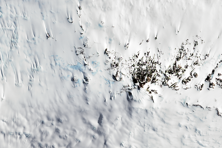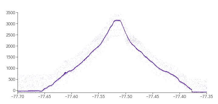

Update on December 12, 2022: This puzzler image shows Mount Terror, a shield volcano located on the eastern side of Ross Island, Antarctica. Congratulations to Garrett Layne, the first person to correctly identify the mountain, its location, and the elevation profile. Special mention goes to Joe Cornelius, who used the elevation profile to identify candidate islands and arrived at the correct answer. Read more about Mount Terror in the Image of the Day.
Every month on Earth Matters, we offer a puzzling satellite image. The October 2022 puzzler is shown above. Your challenge is to use the comments section to tell us where it is, what we are looking at, and why it is interesting. This month, special mention will go to those who can also describe what the visualization below the image is showing.
How to answer. You can use a few words or several paragraphs. You might simply tell us the location, or you can dig deeper and offer details about what satellite and instrument produced the image, what spectral bands were used to create it, or what is compelling about some obscure feature. If you think something is interesting or noteworthy, tell us about it.
The prize. We cannot offer prize money or a trip on the International Space Station, but we can promise you credit and glory. Well, maybe just credit. Within a week after a puzzler image appears on this blog, we will post an annotated and captioned version as our Image of the Day. After we post the answer, we will acknowledge the first person to correctly identify the image at the bottom of this blog post. We also may recognize readers who offer the most interesting tidbits of information. Please include your preferred name or alias with your comment. If you work for or attend an institution that you would like to recognize, please mention that as well.
Recent winners. If you have won the puzzler in the past few months, or if you work in geospatial imaging, please hold your answer for at least a day to give less experienced readers a chance.
Releasing Comments. Savvy readers have solved some puzzlers after a few minutes. To give more people a chance, we may wait 24 to 48 hours before posting comments. Good luck!


The image is showing Mount Terror on Ross Island, Antarctica. The lower image is showing the elevation profile of Mount Terror from South to North. It looks like the image was taken using a standard RGB from Landsat 8 or Landsat 9.
This is an image from the Antarctic Ice sheet. The chart represents elevation (meters) and latitude
Antarctic mountain range
Unusual early spring melt of mountain range in Antarctica.
I’m guessing that it’s the Antarctic Peninsula, and that it’s pretty surprising to see some water-saturated surface at this time of year. I’m guessing that the plot below is an elevation profile from ICESat-2, showing the up and over from one side of the Peninsula to the other.
Guess changed to the Transantarctic Mountains because those plot latitudes are too far south to be on the Peninsula and reaching sea level. 🙂
This is a satellite image of Mount Terror in Antarctica. The visualization is a chart plotting elevation in meters vs latitude. No idea what satellite took it though.
A view of Ross Island, Antarctica…home to McMurdo Station. An elevation profile.
This is an image of Antarctic ice that is thinner than it has been previously allowing some of the land below to show through. It shows some blue ice through a thin layer of snow near the summit of a mountain, possibly Mt. Erebus.
It’s Antarctica and this is the first time this vegetation has
been exposed in [x] amount of years – probably millennia.
Mount Terror on Ross Island, Antarctica.
The chart is of altitude from -77.35 to -77.75 latitude, with sea level at about 77.37 and 77.67, so likely an island.
The chart spans .3° latitude, so 110Km *.3 = 33Km span, from north to south, with a max elevation of ~3,200 meters
Going through Wikipedia’s list of all the Antarctic islands at 77.x latitude, Ross was the first one that approached the proper size and altitude.
Checking Google Maps I was even able to match the image.
This is a thumbnail of the island’s significance, from Wikipedia:
Ross Island was the base for many of the early expeditions to Antarctica. It is the southernmost island reachable by sea. Huts built by Scott’s and Shackleton’s expeditions are still standing on the island, preserved as historical sites.
Today Ross Island is home to New Zealand’s Scott Base, and the largest Antarctic settlement, the U.S. Antarctic Program’s McMurdo Station. Greenpeace established World Park Base on the island and ran it for five years, from 1987 to 1992.
I didn’t know anything about anything and had to confirm it was latitude, below the equator, look up the degree to Km conversion, discover the Wikipedia list and pages on each island, as well as Encyclopedia Westarctica.
This was so much fun, thank you!
PS: Sneaky of you to do the second highest peak on the island. Nice!
–Joe Cornelius
A mountain with snow melting.The graph is how much the snow\glacier has melted throughout time. ???♀️
Is it the Alps? It looked like the Andes but the chart I’d assume is
snowpack and altitude in meters. 3500meters would be the
Swiss Alps I believe
Good evening,
Would you mind my guessing at the above October Puzzler?
Is it the Ural Mountains, specifically the Ural-forest area including Ural-tundra in Russia? The Urals can sometimes account for 20 percent of Earth’s oxygen regeneration.
Whether or not it is the Urals, it is breathtaking.
Thank you.
Icy cliff of a mountain. Blue Ice beneath a section. Probably in Himalaya or Karakoram. Eg mountain passes to Siachen Glacier like Sia La, Bilafond La also show such features in Google Maps
It looks like a melting mountain range in either The Arctic or AnTarctic regions…probably Antartic; More likely the Antartic
Penguin fecal remains
The above image is could be of Glacier. Can be himalayan or Antarctica.
The second graph is showing may be the temperature at the Glacier per depth
Assuming the graph shows latitude vs elevation I suspect this is a satellite photo of Mount Terror, Ross Island, Antarctica.
My first good guess is Fuji Japan, not exact but it comes to mind, a note about the first snowfall at high altitude anywhere on some volcanic mountain
The posted image could show Mountains in Antarctica near McMurdo Station and their profile in altitude.
A try.
Greetings
Georg
Volcano in Antarctica. Mt Sidley.
Blue areas are partially melted ice.
Lichen growing on the visible rocks.
It’s an area just west of Ronne Ice Shelf, north of Vinson Massi.
I personally think it’s a mountain in Antarctica. Could be wrong could be right
Guessed that because of the height going to near sea level
And it looks like it’s not very pointy and it looks smooth
and curved. Probably wrong but I tried and thought.
Hi,
I guess it could be Antarctica , Queen Maud Land.
The light blue patches are ice, molted and refrosted snow.
The blurry part beneath the rocky formation could be snowdust due to winds.
Greenland Ice Sheet. It show pooling lakes that form in summer and can suddenly drain downward toward bedrock.
Greenland
Glacier field in Denali national park. Interesting because the contrast between the bare rock peeking through and the blue depths of one of the crevasses, show how incredibly deep the ice and snow are. The chart shows average temperature in the blue crevass, making 10 measurements per day for a year.
Mt. Terror on Ross Island, Antarctica.
Trees covered by avalanche ice .
could it be Antartica and the dark parts are trees…
This is a satellite image of Mt Terror, an inactive shield volcano in on Ross island in Antartica, located at 77°31′S 168°32′E.
According to a quick search on Wikipedia, Mt Terror is 3,262 meters or 10,699 feet high.
The second image is of an elevation chart.
It seemed to me immediately that the image was of Antarctica. Looking more closely I thought I could spot what looked like a circular formation, slightly offset at about 4 o’clock from the centre of the image. That, along with the elevation chart (which I only saw after I had clicked through to submit my answer!) added some support to my suspicion it was a volcano.
A quick search of contender peaks between 3200 and 3400 meters high narrowed the selection down to just a few. A Google earth comparison confirmed this is indeed Mt Terror.
How about Erebus, Antarctica? Most southerly active volcano & only one on the continent.
Alaska
Just adding a note to my earlier reply of Mount Terror: judging from the shadow cast by a mogul at about 7 ixclock from the rocky peak, I’m guessing that the image is either very recent or taken around the same time of some earlier year?
–Joe Cornelius
Avalanche on the slopes of Everest?
Himalaya it can be
Fossils becoming unearthed…
I’m guessing Antarctica and the blue patches are showing the ice is melting.