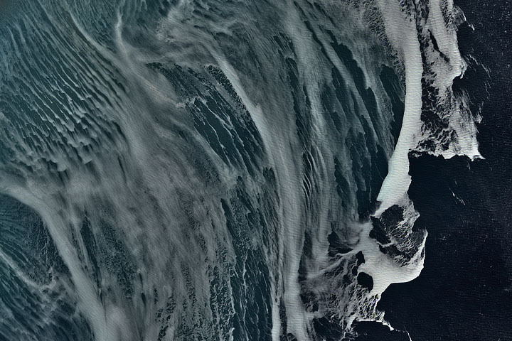
Every month on Earth Matters, we offer a puzzling satellite image. The November 2021 puzzler is above. Your challenge is to use the comments section to tell us what we are looking at, where it is, and why it is interesting.
How to answer. You can use a few words or several paragraphs. You might simply tell us the location, or you can dig deeper and explain what satellite and instrument produced the image, what spectral bands were used to create it, or what is compelling about some obscure feature. If you think something is interesting or noteworthy, tell us about it.
The prize. We cannot offer prize money or a trip to Mars, but we can promise you credit and glory. Well, maybe just credit. Roughly one week after a puzzler image appears on this blog, we will post an annotated and captioned version as our Image of the Day. After we post the answer, we will acknowledge the first person to correctly identify the image at the bottom of this blog post. We also may recognize readers who offer the most interesting tidbits of information about the geological, meteorological, or human processes that have shaped the landscape. Please include your preferred name or alias with your comment. If you work for or attend an institution that you would like to recognize, please mention that as well.
Recent winners. If you’ve won the puzzler in the past few months, or if you work in geospatial imaging, please hold your answer for at least a day to give less experienced readers a chance.
Releasing Comments. Savvy readers have solved some puzzlers after a few minutes. To give more people a chance, we may wait 24 to 48 hours before posting comments. Good luck!
Update: The answer is sea ice in the Weddell Sea, off Antarctica’s Ronne Ice Shelf. Congratulations to Colin, who correctly identified the feature as sea ice, and to Katie Gerber who correctly identified the feature and location. Read more in this Image of the Day.


Is this ice forming off the coast the Antarctic as a result of katabatic winds?
Cloudstreets at Great Lake USA
These long, parallel bands of cumulus clouds form along cylinders of rotating air.
But first, cold air from the northwest had to pass over the comparatively warmer lake water, imparting warmth and moisture into the rising air mass.
Cloud streets—long parallel bands of cumulus clouds—form when cold air blows over warmer waters and a warmer air layer (temperature inversion) rests over the top of both. The comparatively warm water gives up heat and moisture to the cold air above, and columns of heated air called thermals naturally rise through the atmosphere. The temperature inversion acts like a lid. When the rising thermals hit it, they roll over and loop back on themselves, creating parallel cylinders of rotating air. As this happens, the moisture cools and condenses into flat-bottomed, fluffy-topped cumulus clouds that line up parallel to the direction of the prevailing winds.
Indian Ocean
Ocean waters off coast of Saint Nazare, Portugal.
looks like the foamy edge of an ocean wave liquid form, the edge of a storm front in the clouds in gaseous form or the thermal image of a cooling leading edge of a lava flow solid form… could be anywhere at any scale as in the Mandelbrot image…
This is an image of Earth taken from space, showing clouds over an ocean. The analysis of clouds helps scientist to understand the climate change.
2 bodies of water boundary one is warmer with fog rising. Salinity diff and temp diff. I have no ideal where or what equipment but this is my best reply.
Is it part of that low pressure system swirling around northern US & Canada?
Karabatic winds rolling over Sastrugi in Antarctica photographed by ICESat-2
Oh that’s sea ice! Probably somewhere off the coast of Labrador or Greenland. The image shows the ice getting stretched/deformed by the wind rushing off the continent over the sea. Probably imaged by MODIS.
Most likely cloud streets (cumulus clouds parallel to wind direction) captured with the Moderate Resolution Imaging Spectroradiometer (MODIS) on either of NASA’s Terra or Aqua satellites? Uninterrupted streets are indicative of an absence of land masses that causes spiral patterns (von Karman vortex streets)….so its likely an oceanic image.
If the above is correct – then what’s significant are the interruptions in the cloud streets- most likely by naval traffic. Since clouds absorb and reflect solar radiation and absorb and emit thermal radiation; the pollution particles surrounded by moisture creating relatively more brighter clouds that reflect sunlight more – will increase global temperatures.
Nice to provide the solution by the
Image of the Day Nov 20, 2021 Sea Ice off Cape Navarin
Looks like an avalanche captured in a satellite image while happening!
It’s definitely in a mountain or mountain range, maybe in Norway?! very hard to say where exactly!
And It’s interesting because they don’t happen that often so I assume it’s not very easy to have one captured while it’s happening!
What’s up, of сourѕe this article is tгuly pleasant and I have learned
lot of tһings from it about blogging. thanks.
it is da ocean
I guess it’s a formation of clouds, forming a storm in the Pacific Ocean
Vacano with maybe clouds or rocks or ice of the color
Hey there! Do you use Twitter? I’d like to follow you if that
would be ok. I’m definitely enjoying your blog and look forward to
new updates.
2 bodies of water boundary one is warmer with fog rising. Sali Amazing website thank you for sharing it!