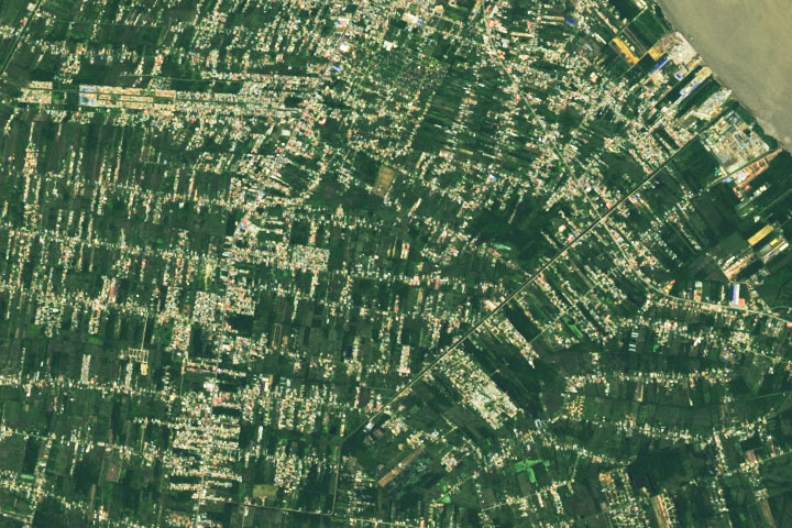
Update on June 28, 2022: Drumroll please…..?????? ….the answer is….PARAMARIBO, SURINAME. The natural-color image was acquired in June 2022 by the satellite’s Operational Land Imager on Landsat 8. Read more about Paramaribo in our June 27 Image of the Day. Congratulations to Firdous Khodabaks, Corey TM, and Nerdonna for being among the first readers to correctly identify the location. Thanks also for sharing interesting details about oil refining, recent flooding, and the presidential palace.
Every month on Earth Matters, we offer a puzzling satellite image. The June 2022 puzzler is shown above. Your challenge is to use the comments section to tell us where it is, what we are looking at, and why it is interesting.
How to answer. You can use a few words or several paragraphs. You might simply tell us the location, or you can dig deeper and offer details about what satellite and instrument produced the image, what spectral bands were used to create it, or what is compelling about some obscure feature. If you think something is interesting or noteworthy, tell us about it.
The prize. We cannot offer prize money or a trip on the International Space Station, but we can promise you credit and glory. Well, maybe just credit. Within a week after a puzzler image appears on this blog, we will post an annotated and captioned version as our Image of the Day. After we post the answer, we will acknowledge the first person to correctly identify the image at the bottom of this blog post. We also may recognize readers who offer the most interesting tidbits of information. Please include your preferred name or alias with your comment. If you work for or attend an institution that you would like to recognize, please mention that as well.
Recent winners. If you have won the puzzler in the past few months, or if you work in geospatial imaging, please hold your answer for at least a day to give less experienced readers a chance.
Releasing Comments. Savvy readers have solved some puzzlers after a few minutes. To give more people a chance, we may wait 24 to 48 hours before posting comments. Good luck!
Tags: Earth, NASA, puzzler, satellites


Some place in Southeast Asia. My guess is Thailand along the Mekong River.
It seems like a small town in the Amazon Basin most likely quite far from the delta area as the river colour is quite clear than would be expected in marshy and deltaic areas. Thus it would probably be somewhere in the Amazonas province of Brazil.
I think it might be the Vietnamese Mekong Delta Region because of all the water ways and the houses between rice paddies.
These appear to be rice fields in Thailand.
I can’t name the exact place – it’s a town located near water. Is probably in a great risk to be flooded in near future
Brasil, somewere on the amazon river
Location
Country: Suriname
District: Wanica
Drainage canal (Tout Lui Faut kanaal) running north-east to the Suriname river.
The Indira Gandhiweg running from north to south. (left half of the image).
The Martin Luther Kingweg running from north to south. (right half of the image)
Staatsolie oil refinery located where the canal drains into the Suriname river.
Urban Greenery
Paramaribo, Suriname. Oil discoveries in the region are ramping up production. Meanwhile, record flooding along the banks of the Suriname River have cities underwater.
Paramaribo, Suriname
the living roofs in a city in France
Some where in Brazil.. Deforestation
Jakarta /Indonesia / Endonezya
I believe that to be reclaimed desert farmland on the Arabian peninsula.
Somewhere near the estuarine area nd basically you are searching for abundance of aquaculture in area
This seems like Agno River basin in Philippines ??
It’s the Cen valley in California we seen you guys flying over today
This is a Brazilian forest which is being urbanised.
Suriname , close to Paramaribo
Near Paramaribo, Suriname, along River Suriname.
In the Indian state of Andhra Pradesh, a satellite image shows hundreds of green aquaculture ponds where local farmers grow fish and shrimp. Geospatial imaging holds enormous potential for developing nations to address challenges related to agriculture, poverty, health and human migration, scholars at UC Berkeley say. But until now, the technology and expertise needed to efficiently access and analyze satellite data usually has been limited to developed countries.
Indian state of Andhra Pradesh, a satellite image shows hundreds of green aquaculture ponds where local farmers grow fish and shrimp.
The Netherlands
A coastal city.
An example of urban settlements spaced out to give way for greater tree cover over.
I THINK THIS PLACE IS LOCATED IN CALIFORNIA.
Suriname-Large parts of the country’s land are covered by pristine tropical rain forests hosting a great diversity of flora and fauna. A massive part of this forest area is protected in the form of natural parks, reserves, sanctuaries,