

We published a photograph of a lone turquoise melt pond as our Image of the Day on August 2, 2014. Although that was one of the largest that scientists participating in the 2014 MABEL campaign saw, it certainly wasn’t the only one. In fact, that melt pond had plenty of company—and we had no shortage of photos of them.
The digital camera that captured the lone melt pond was taking a picture every 3 seconds, with each frame showing an area about 2.5 by 1.5 kilometers (1.6 by 0.9 miles). There were thousands of photographs to choose from, and many of them were spectacular. Above are two favorites. The upper image shows several narrow melt ponds and surface streams on a glacier in southeastern Alaska; the lower photo shows even more melt ponds on thinning sea ice.
Though melt ponds make for nice aerial photographs, they’re also a topic of great interest to scientists. In 2012, American researchers published an interesting study that detailed how melt ponds produce fractal patterns that can be useful for understanding the dynamics of sea ice melting. (For a more readable write-up, try this Scientific American blog post.) In 2014, scientists from the United Kingdom argued that the amount of water in spring melt ponds could be used to make skillful predictions about how much ice will melt during the height of summer.
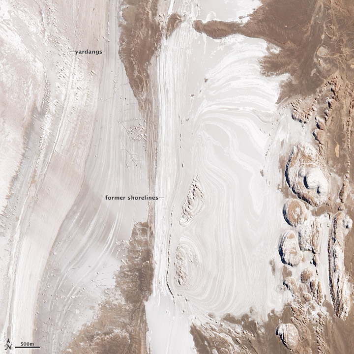
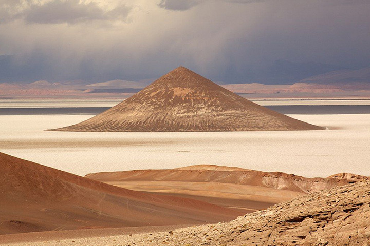
Congratulations to Joe Clark for being the first to solve our June puzzler. The answer was the Salar de Arizaro in Argentina’s Salta province. Though once bathed in water, the landscape is now bone dry due to evaporation, baking sunlight, and fierce winds. Read more about it in the image of the day we published on June 28, 2014. Also, check out this spectacular shot of the Cono de Arita (a distinctive conical hill sculpted from sandstone) from Ben Stubbs.

Every month on Earth Matters, we offer a puzzling satellite image. The June 2014 puzzler is above. Your challenge is to use the comments section to tell us what part of the world we are looking at, when the image was acquired, what the image shows, and why the scene is interesting.
How to answer. Your answer can be a few words or several paragraphs. (Try to keep it shorter than 200 words). You might simply tell us what part of the world an image shows. Or you can dig deeper and explain what satellite and instrument produced the image, what spectral bands were used to create it, or what is compelling about some obscure speck in the far corner of an image. If you think something is interesting or noteworthy, tell us about it.
The prize. We can’t offer prize money, but, we can promise you credit and glory (well, maybe just credit). Roughly one week after a puzzler image appears on this blog, we will post an annotated and captioned version as our Image of the Day. In the credits, we’ll acknowledge the person who was first to correctly ID the image. We’ll also recognize people who offer the most interesting tidbits of information about the geological, meteorological, or human processes that have played a role in molding the landscape. Please include your preferred name or alias with your comment. If you work for or attend an institution that you want us to recognize, please mention that as well.
Recent winners. If you’ve won the puzzler in the last few months or work in geospatial imaging, please sit on your hands for at least a day to give others a chance to play.
Releasing Comments. Savvy readers have solved many of our puzzlers after only a few minutes or hours. To give more people a chance to play, we may wait between 24-48 hours before posting the answers we receive in the comment thread.
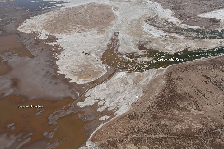
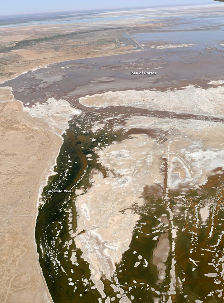
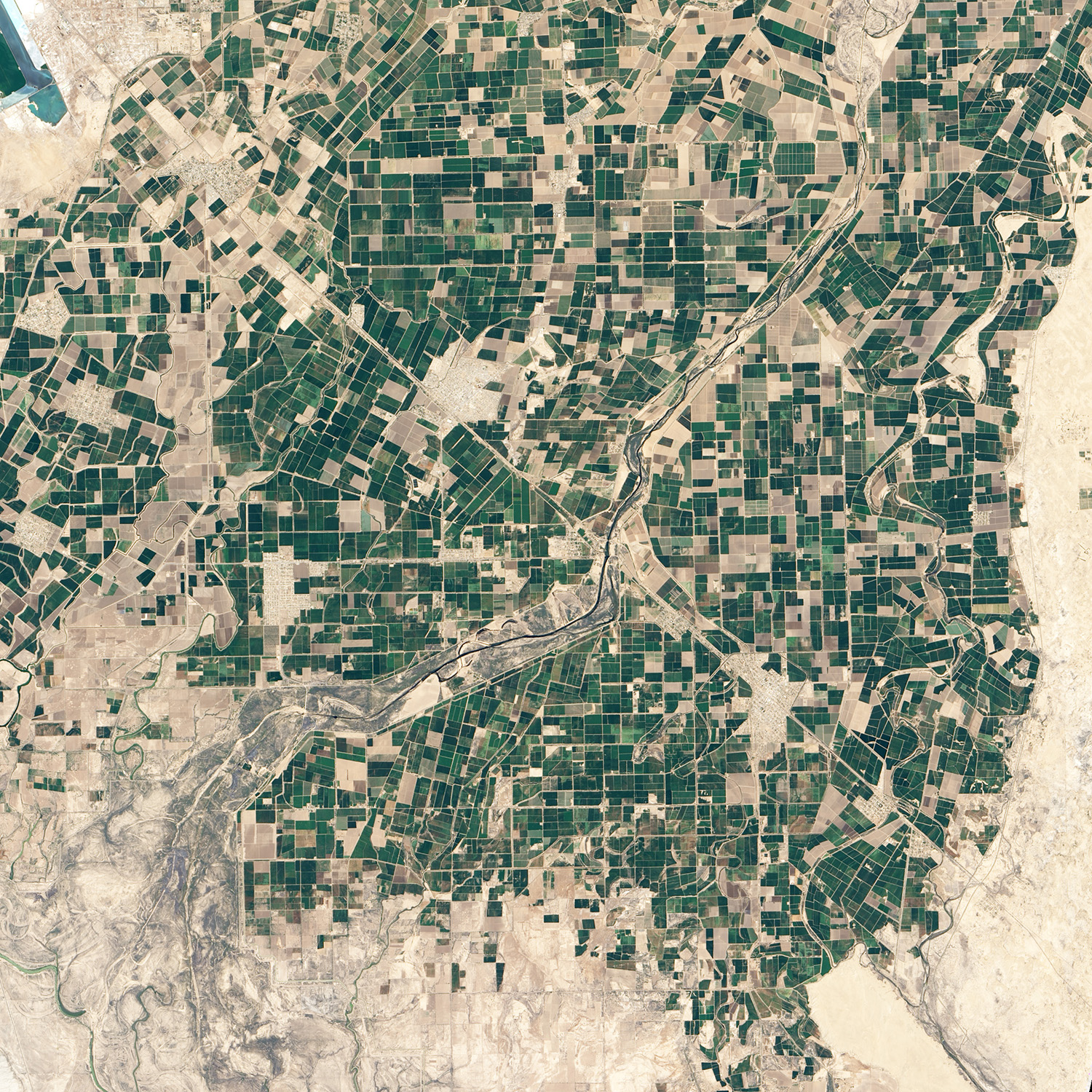
When the Minute 319 “pulse flow” began in March 2014, it was not clear whether the effort would be enough to reconnect the Colorado River with the Sea of Cortez. Some hydrologists thought there might be just enough water; others were less optimistic. It turns out the optimists were right, though just barely. For the first time in sixteen years, the Colorado River was reunited with the Sea of Cortez on May 15, 2014.
While scientists involved in the effort point out the goal was always to recharge groundwater and deliver water to special ecological restoration zones, environmental advocates haven’t been shy about basking in the symbolic importance of the river reaching the sea. “Now that we’ve witnessed the Colorado flowing in its delta, we know that it is possible to conjure the river back to life where the world thought it was dead. It’s a resurrection that we won’t soon forget, and a vision of what could be in the future,” wrote Jennifer Pitt, the director of the Environmental Defense Fund’s Colorado River Project in an article published by National Geographic.
Francisco Zamora, director of the Sonoran Institute’s Colorado River Delta Legacy Program, took these photograph from a Lighthawk-supported plane on May 15, 2014. See the Sonoran Institute’s Facebook page for more images. To learn more about the scientific rational behind the pulse flow, see this EOS article. View satellite imagery of the pulse flow here.

Scientists involved in the Minute 319 “pulse flow” say the effort has achieved its main objective: delivering water to special ecological restoration zones along the Colorado River. While cottonwood and willows have retreated from most areas due to a lack of water, conservation groups including the Sonoran Institute and Pronatura Noroeste have been working to revive ecosystems in areas where there is good soil and perhaps enough groundwater and farm runoff to support forests.
At the Laguna Cori, Laguna Grande, and CILA sites, for instance, the Sonoran Institute has been planting saplings, removing invasive plants, and grooming the landscape to make it more likely for trees to germinate. On April 16, 2014, the Operational Land Imager (OLI) on Landsat 8 observed water from the pulse flow replenishing wetlands in these area with water. For comparison, the lower image was acquired on March 31, 2014. The aerial image at the top of the page, first published by the Sonoran Institute, shows the Laguna Granda ecological zone inundated with water on April 14, 2014.
April 16, 2014
While greening is not yet visible to Landsat 8, the effects of the pulse flow are visible at ground level. On April 29, the Sonoran Institute began tweeting some of the first images of tree seeds germinating in response to the flow.

To learn more about the pulse flow, read Restoring a Pulse to the Lower Colorado and A River Renewed.
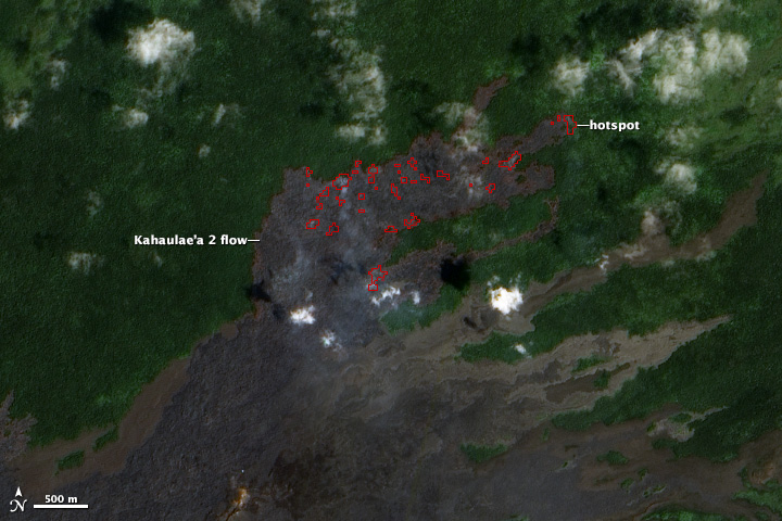
The Earth Observing-1 (EO-1) satellite was orbiting at an altitude of about 700 kilometers (400 miles) when it captured our April 11 Image of the Day — a nadir view of Kilauea’s Kahaualeʻa 2 lava flow creeping through forests northeast of Pu’u ’O’o crater. Much closer to the surface, the U.S. Geological Survey monitors the lava flow with helicopter overflights.
The image below shows a portion of the flow as it appeared on March 7, 2014. The smoke near the flow front is caused by lava burning trees and other vegetation in ohia lehua forests. Gases emanating from the vent are visible on the upper left.

(Credit: US Geological Survey/Hawaiian Volcano Observatory)
For more aerial imagery of Kahaualeʻa 2, visit the Hawaiian Volcano Observatory’s multimedia page. The image below was acquired by satellite on March 11, 2014. Click on it for more details.
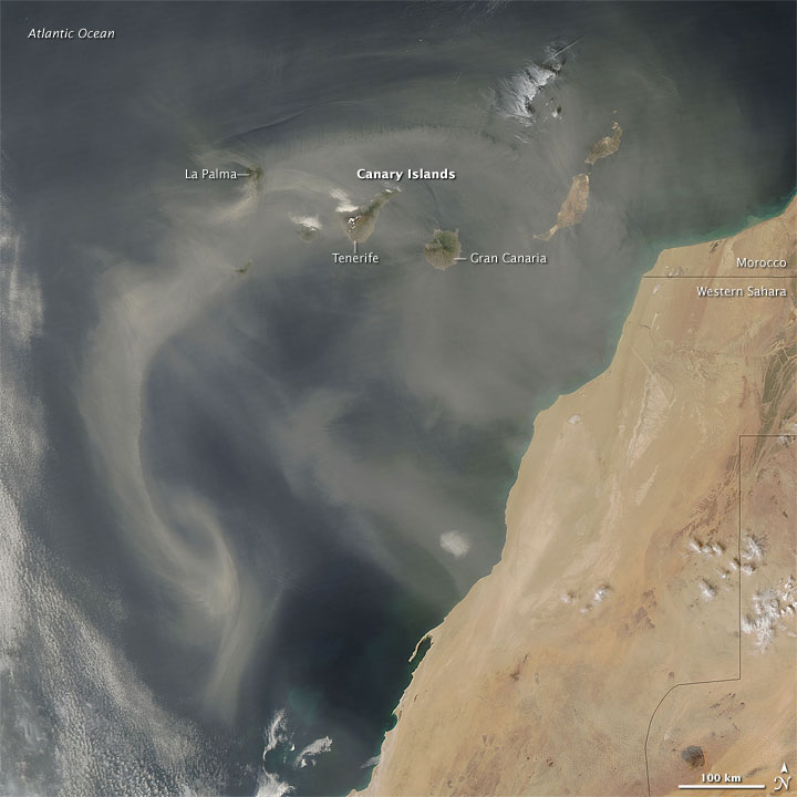
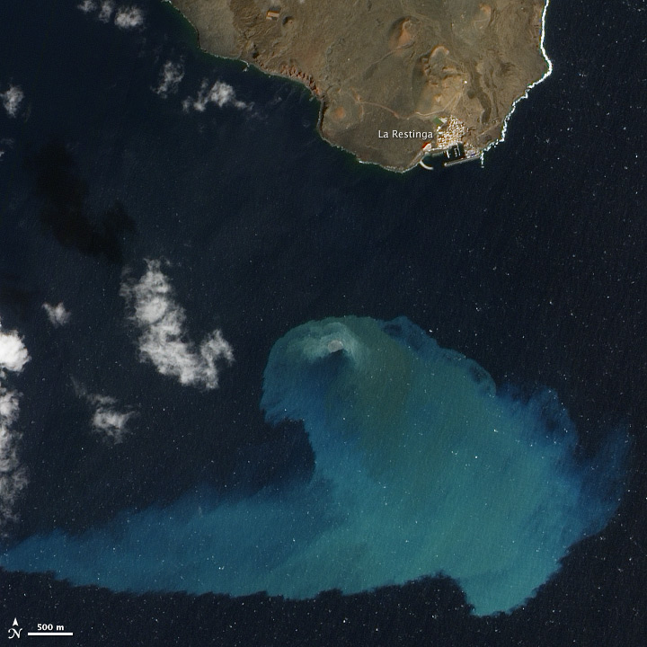
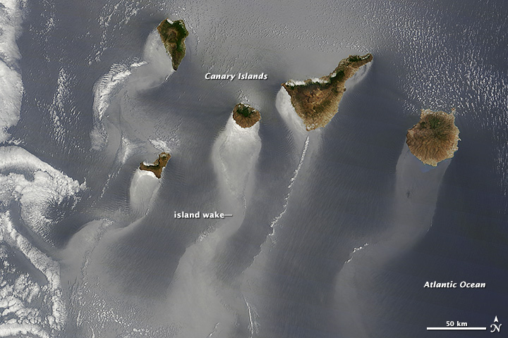
For the second year in a row, an image from the Canary Islands took the championship of Tournament: Earth. In 2013, a submarine volcano near El Hierro Island was the crowd favorite. This year, it was a shot of the entire island chain that dominated the vote. When “Trailing the Canaries” faced “Activity at Kliuchevskoi” in the championship round, it wasn’t just a win for the Canaries image; it was a blowout. Of the nearly 50,000 votes cast, 96 percent went to the Canary Islands image.
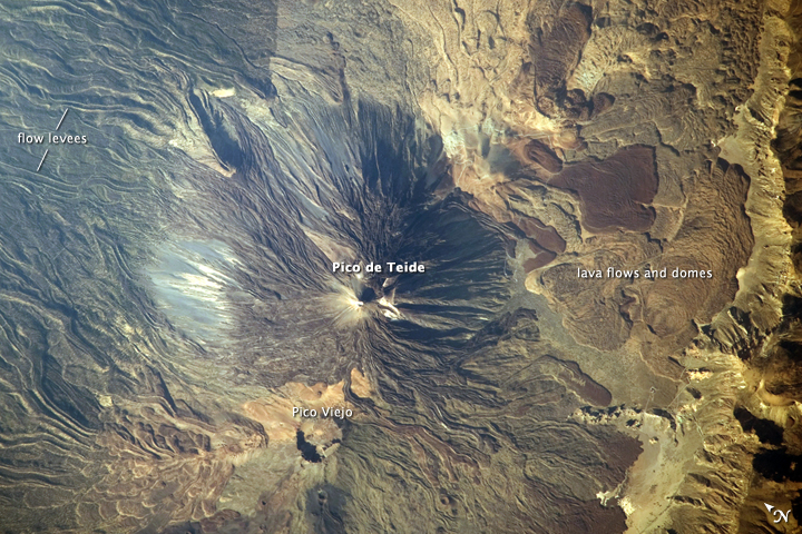
To salute our many readers from the Canaries, we’ve combed through our archives and selected five of our all-time favorite images involving the island chain. They are posted below from oldest to newest. Click on each image for more details. Enjoy!
Dust over the Canary Islands (March 2009)
Teide Volcano (July 2009)
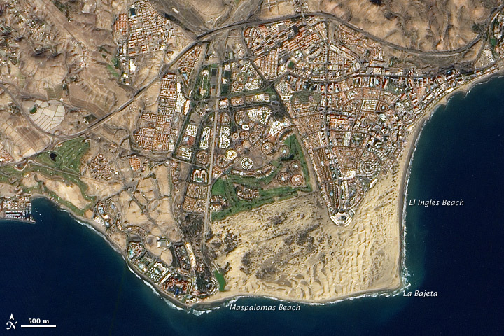
Sand and Tourism in Gran Canaria (January 2013)
El Hierro Submarine Volcano Eruption (2013 Tournament Earth Champion)
Trailing the Canaries (2014 Tournament Earth Champion)

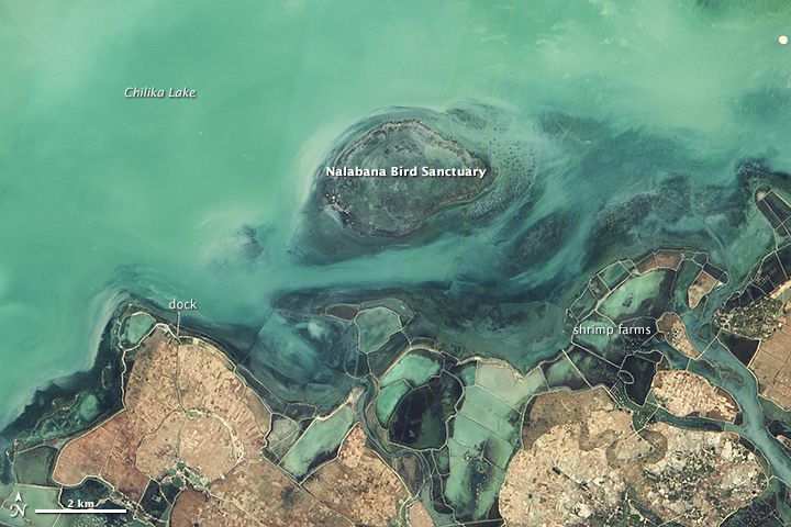
I thought the March Puzzler would be an easy one, but it turned out to be one of the more difficult we’ve posted. As explained in our March 29, 2014, Image of the Day, the image shows Nalabana Bird Sanctuary in India’s Chilika Lake. Despite more than 50 guesses on Earth Matters and 500 on Facebook, nobody came up with the exact location. However, many readers (including Steve Martin and Wendy Spiteri) did recognize the shrimp farms or that it was somewhere in India.
I kept the caption to a few paragraphs, but there’s a lot more that could be written about Chilika Lake. It’s a beautiful and fascinating place that faces environmental, economic, and political challenges that are as complicated as anywhere in the world. In 2002, for instance, authorities dredged a new connection with the Bay of Bengal after silt narrowed the existing mouth and made it more difficult for salty water to enter the lake. While the new mouth increased salinity levels, it did little to resolve the pitched debate between shrimp farmers and traditional fishing communities that has simmered for years. In 1996, the Supreme Court of India banned aquaculture within 1,000 meters (3,300 feet) of Chilika Lake because of environmental concerns, yet enclosures known as “gheries” (which are even visible to satellites…see page 50 of this Powerpoint) remain widespread. You can read more about the ongoing debate about aquaculture in Chilika Lake from Infochange, Economic Times, Radio Netherlands, and the Times of India.
Flickr user Adita Pany took the photograph of flamingos at Nalabana shown above in 2007. The QuickBird satellite caught a glimpse of a stand of flamingos near Nalabana in 2005.
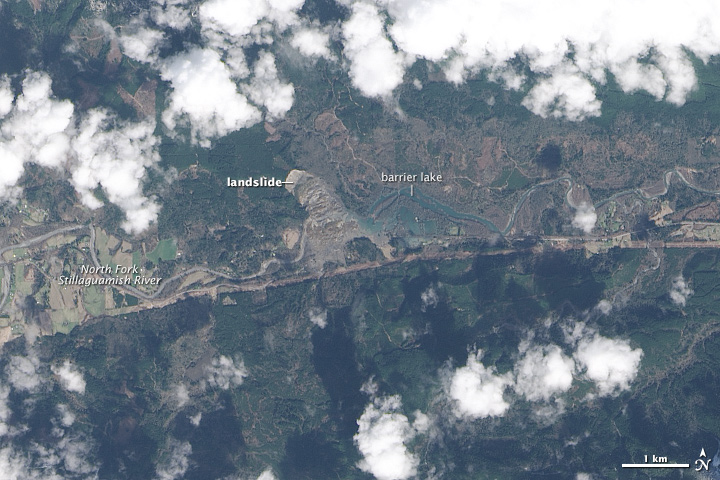
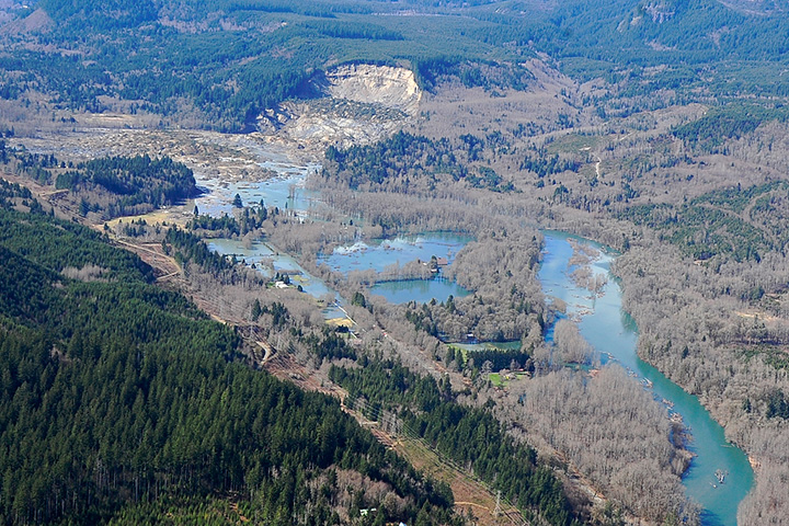
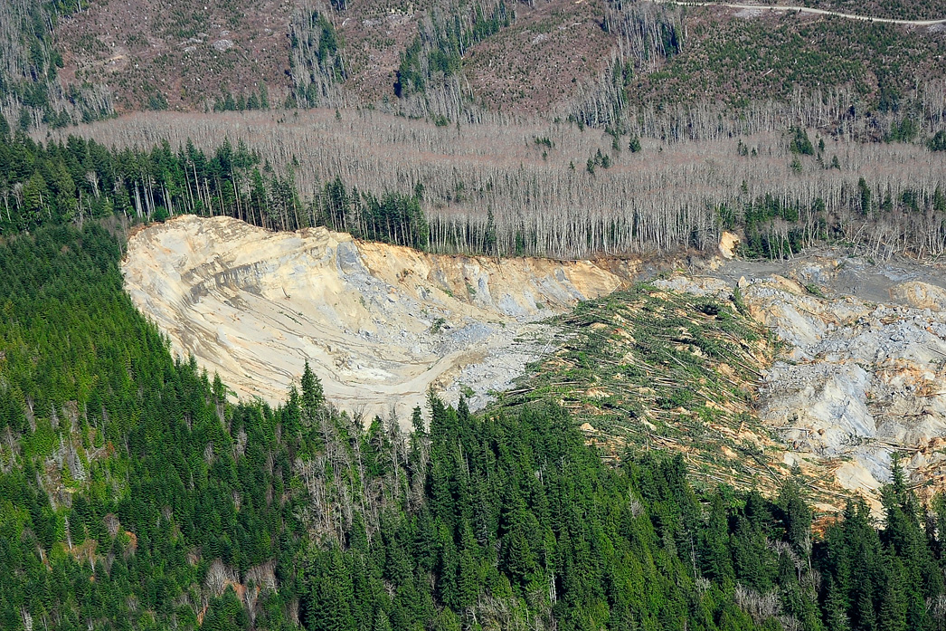
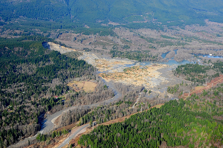
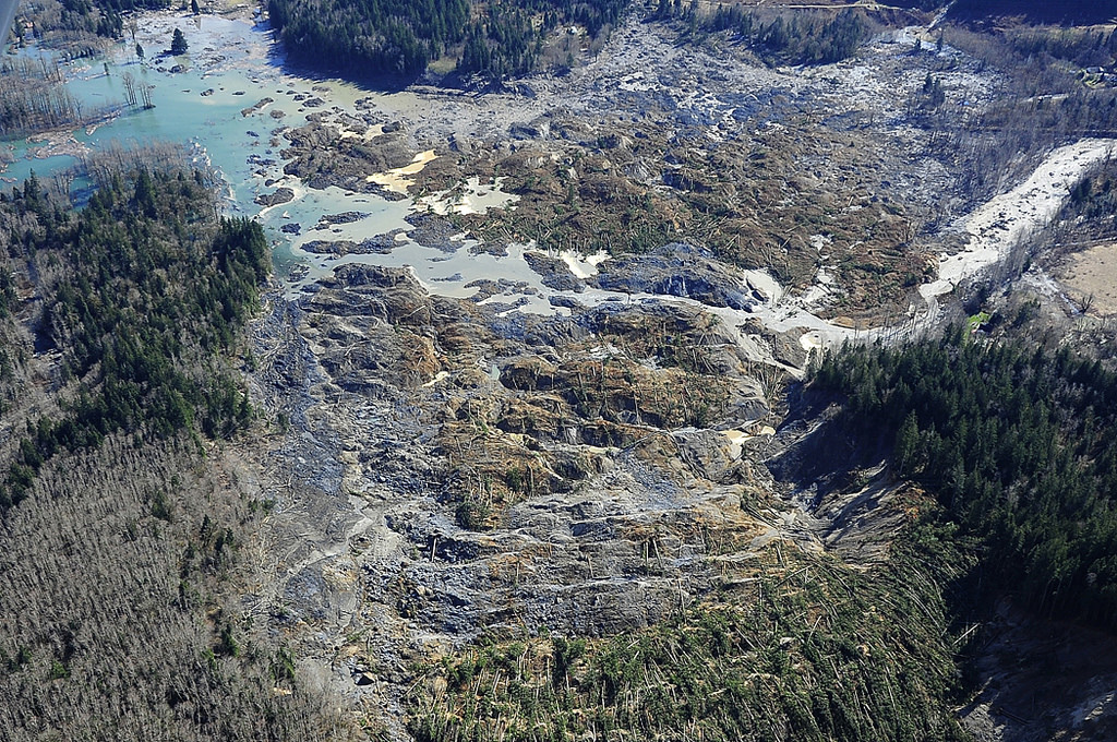
On March 25, 2014, we published this nadir view of debris and a barrier lake created by a major landslide near Oso, Washington; the image was acquired by the Landsat 8 satellite on March 23. While top-down satellite views are Earth Observatory’s specialty, such images can be challenging to interpret because of how foreign the scale and topography appear from above as compared to how we normally see the world from the ground. To help make the nadir perspective more intuitive, I try to share matching aerial or ground photography when it is available. The set of images below, originally published by the office of Washington State Governor Jay Inslee, was taken during an aerial survey on the same day that Landsat 8 acquired its image. For more photographs of the landslide, visit Inslee’s Flickr page.
It’s funny what you can find in a satellite image. Mike Gartley, a research scientist at Rochester Institute of Technology, spotted the Landsat 5 satellite lurking in a Landsat 8 image of northwestern Brazil.
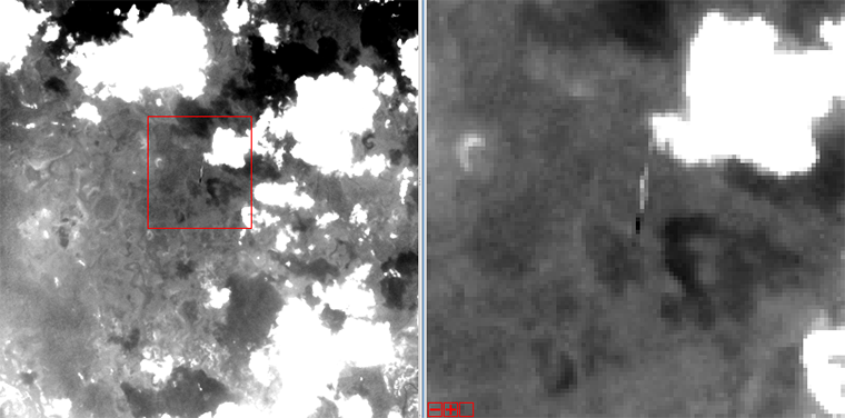
Landsat 5 is just a few blurry pixels in Landsat 8’s panchromatic band.
Landsat 5 once flew in the orbit that Landsat 8 now lives in. But in January 2013, the U.S. Geological Survey lowered L5’s orbit about 23 kilometers (14 miles) as part of the decommissioning process. The satellite is now in a disposal orbit, slowly being dragged back to Earth.
Landsat 8, meanwhile, reached its final orbiting altitude of 705 kilometers (438 miles) on April 12, 2013. On November 22, Landsat 8 flew over the defunct Landsat 5 satellite, capturing this view of its predecessor. Landsat 5 is just a few pixels across and is only visible at all because it is much closer to Landsat 8 than it is to Earth. See additional images from the November 22 overflight on NASA’s Landsat web site.
Finding Landsat 5 in the image was a matter of course for Gartley, who routinely hunts for space objects in Landsat images. As of December 2011, more than 22,000 “resident space objects” were in orbit around the Earth. The Space Surveillance Network tracks all of these objects with telescopes, radars, and a computer model. Gartley uses this information to figure out when an object will fly into Landsat 8’s view.
“Believe it or not, there are anywhere from 1 to 4 such underflights of space objects that are passing through the field of view of Landsat 8 on any given day,” says Gartley. “Many of the objects are old rocket bodies and COSMOS satellites (Tselina-D ELINT type), while the ISS has also popped up at least three times since last May.”
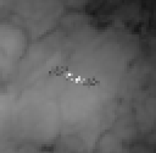
The International Space Station seen from Landsat 8.
Landsat 5’s appearance is appropriate: it’s the satellite that just won’t go away. The tenacious satellite was built to operate for 3 years, but worked for more than 29, setting a world record for the longest operating Earth observation satellite. Even the decommissioning process took longer than expected because the satellite kept running. Hear the story from longtime flight systems manager for Landsat 5, Steve Covington, in this recorded talk originally given at the Library of Congress:
[youtube qEluMLptXfo]

