
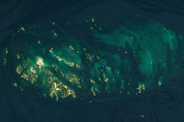
Update on June 13, 2023: This puzzler image shows France’s Chausey Islands (Îles Chausey), around low tide on July 22, 2018. The islands are subject to some of the largest tidal ranges on Earth. Congratulations to Michelangelo Grillo, who was the first to identify the correct location. Grillo was also the first to mention the region’s extreme tides. View the same area during high tide in our Image of the Day story.
Every month on Earth Matters, we offer a puzzling satellite image. The May 2023 puzzler is shown above. Your challenge is to use the comments section to tell us where it is, what we are looking at, and why it is interesting.
How to answer. You can use a few words or several paragraphs. You might simply tell us the location, or you can dig deeper and offer details about what satellite and instrument produced the image, what spectral bands were used to create it, or what is compelling about some obscure feature. If you think something is interesting or noteworthy, tell us about it.
The prize. We cannot offer prize money or a trip on the International Space Station, but we can promise you credit and glory. Well, maybe just credit. Within a week after a puzzler image appears on this blog, we will post an annotated and captioned version as our Image of the Day. After we post the answer, we will acknowledge the first person to correctly identify the image at the bottom of this blog post. We also may recognize readers who offer the most interesting tidbits of information. Please include your preferred name or alias with your comment. If you work for or attend an institution that you would like to recognize, please mention that as well.
Recent winners. If you have won the puzzler in the past few months, or if you work in geospatial imaging, please hold your answer for at least a day to give less experienced readers a chance.
Releasing Comments. Savvy readers have solved some puzzlers after a few minutes. To give more people a chance, we may wait 24 to 48 hours before posting comments. Good luck!
Tags: NASA, puzzler, satellites
Great Barrier Reef Toxic Plankton Bloom
La photo représente une île, sans doute récemment formée, dont seuls quelques pointes, plus hautes, sont immergées. Quelques plages de sable sont visibles également. La couleur de l’océan qui l’entoure est très sombre et fait penser que les profondeurs sont importantes. Cet ensemble d’îlets est donc certainement dans un océan profond, comme le Pacifique. L’objectif d’observation de cet espace serait de mesurer la montée des océans. Sans doute inaccessible, cet espace peut être observé depuis un satellite par des scientifiques spécialisés dans le suivi de la montée des océans.
The Great Barrier Reef
It à Forest wirh boreal and sandy haven
It’s a typoon in forest with sea grasse
Il s’agit des Minquiers dans la mer de la Manche (English Channel).
The image shows Chausey Island arcipelago in the gulf of Saint-Malo, Normandy, France.
The Number of this islands is around 50 with high tide and more than 300 with low tide, the tidal range is very large, with up to 14 meters differenze between low and High tide.
This is the Chausey Islands, part of the Channel Islands in the English Channel, just off the coast of Normandy. Unlike Jersey and Guernsey which are self-governing British Crown Dependencies, Chausey is administratively apart of mainland France. The area is interesting as it is an archipelago of islands, islets, rocks and sandbanks in an area subject to a massive tidal range of 14.5 metres. In this natural colour satellite image (Landsat bands 4/3/2) the water is particularly clear, showing the mixed topography of rocks, sandbanks, vegetated islands and navigable channels. The water clarity makes it hard to see what precisely is above and below the waterline at the time of image acquisition. However were we to look at the satellite spectral bands 5, the contrast would be particularly strong between ‘wet’ and ‘dry’ due to the strong absorption of infrared by water, effectively making the sea water completely opaque.
Chausey, French Channel Islands. Featured ASTER image gallery on March 6, 2023. Chausey is a group of small islands and islets off the coast of Normandy and is part of the French Channel Islands. Chausey bounced back and forth between England and France for 800 years before finally officially belonging to France in the 19th century. The archipelago comprises 365 islands at low tide, compared to only 52 islands at high tide.
This satellite image is of somewhere in the South Pacific (e.g., the South China Sea?). The light green spots are islands. The dark blue is seawater. The light blue areas are where phosphorescent algae are present. The white lines at the base of the image are the wakes of boats (or possibly the contrails of aircraft).
I will not lie, I thought it was a Mitochondria
Iles Chausey archipelago near Normandy, France.
They are a group of small off the coast of Normandy, in the English Channel called Chausey
Looks very much like the Iles Chausey, France.
An archipelago in the setting sun (or rising sun) in a shallow sea. The sun is illuminating some of the higher islands. There is a ship’s wake at the bottom of the picture. No idea where.
My guess is the Archipelago Islands significant for biodiversity and unique species found nowhere else on earth
Looks like Chausey Islands during low tide. Located in the English canal and its tidal change can be as high as 14meters
This place is the (cluster) of Chausey islands in the north of France.
Thank you for sharing the May Puzzler from NASA Earth Observatory. The image is fascinating and it’s exciting to see how satellite imagery can be used to capture unique perspective.. It seems that the image shows a river delta in Argentina The delta is formed by the Paraná River as it flows into the Rio de la Plata. It’s interesting to see how the river has shaped the landscape over time and how it continues to change today.
Highest Regards,
Michael Wichkoski