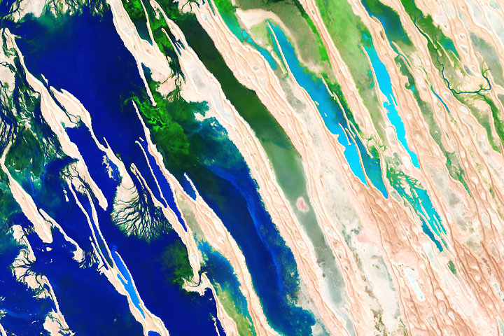
Update on May 2, 2023: This puzzler image is a false-color view of seasonal flooding of Australia’s Diamantina River in April 2023. Congratulations to Steve Hawkins for being the first reader to correctly identify the image and to David Smith for finding its exact location. Read more about the location in our Image of the Day story.
Every month on Earth Matters, we offer a puzzling satellite image. The April 2023 puzzler is shown above. Your challenge is to use the comments section to tell us where it is, what we are looking at, and why it is interesting.
How to answer. You can use a few words or several paragraphs. You might simply tell us the location, or you can dig deeper and offer details about what satellite and instrument produced the image, what spectral bands were used to create it, or what is compelling about some obscure feature. If you think something is interesting or noteworthy, tell us about it.
The prize. We cannot offer prize money or a trip on the International Space Station, but we can promise you credit and glory. Well, maybe just credit. Within a week after a puzzler image appears on this blog, we will post an annotated and captioned version as our Image of the Day. After we post the answer, we will acknowledge the first person to correctly identify the image at the bottom of this blog post. We also may recognize readers who offer the most interesting tidbits of information. Please include your preferred name or alias with your comment. If you work for or attend an institution that you would like to recognize, please mention that as well.
Recent winners. If you have won the puzzler in the past few months, or if you work in geospatial imaging, please hold your answer for at least a day to give less experienced readers a chance.
Releasing Comments. Savvy readers have solved some puzzlers after a few minutes. To give more people a chance, we may wait 24 to 48 hours before posting comments. Good luck!


Mouth/delta of the Colorado River.
How is that, MK Boruki? The Colorado runs dry long before it reaches where it *used* to have a mouth to the Sea of Cortez. Now that area is just a long-dry riverbed.
Fingers lakes
Or lençóis maranhenses
I think this is the inland delta of the Niger River in Mali. Wonderful interplay of linear sand dunes and interdunal wetlands. And the subject of one of my all-time favorite, beautiful satellite images.
Niger inland delta
Lake(s) in California refilling due to recent heavy rains.
Flooding in death Valley
Appears to be a segment of the Amazon river’s delta in Brazil.
Okavango Delta. and differing color bands may be plant density, or water depth ?
Okawango delta with beautiful deltas created by more or less deep waters.
Wetlands of Adair Bay
Sundarbans
Mouths of Rivers
Okavango delta (Botswana) in annual flood.
Río Grande, Tierra del Fuego, Argentina.
Iceland, SE coast
Looks like somewhere in or around Australia’s Simpson Desert, which, I think you posted a while back had some pretty rare rainfall events lately. I don’t see anywhere with quite the same colours, but the terraine is pretty distinctive.
A massive kelp bloom some 5,000 miles across is moving across the Atlantic and could head for Florida’s Gulf of Mexico coast.
The sargassum mass is visible from space and could be one of the largest detected in history.
Red tide and blue algae come from different microorganisms. The red tide is caused by the species Karenia brevis, while a report issued to Manatee County commissioners recently identified the cyanobacterium Lyngbya as the cause of the local blue-green algae outbreak.
Hi,
This is a sattelite image of a desert in thé south east if Iran “kavir lut” which is normally dry. But in 2021 there was a rain and inondation thare which changed thé surface a lot.
Thanks for the photo
Kaveh RADFAR
kradfar@yahoo.com
Desert flood somewhere maybe Namibia south from Luderitz (?)
Parque Nacional dos Lençóis Maranhenses In Brazil
A satellite image of a region in North America. It is a river delta with various channels and a small lake, surrounded by wetlands and vegetation. It provides ecological value and for protecting against flooding.
I’d guess an endorheic basin with a lot of dune action during a flood event. Probably either the Sahara or maybe central Australia. Looks like Landsat, probably using one of the SWIR bands, 6 or 7 on Landsat 8/9.
Okay yup, found it. Got curious and looked in the Sahara and in Australia, and spotted some north-northwest/south-southeast trending features in the Simpson desert, and actually found the exact features from the image in southwest Queensland, maybe 120km or so ENE of the little town of Birdsville. Definitely a flood event, almost certainly captured by Landsat or a similar sensor, and if Landsat it’s probably using Red and Green values from Bands 4 and 3 respectively, and then either Band 6 or 7 for Blue.
Canada
Is it part of the Ganges delta?
I founded second idea
west of Cairo desert dunes have the same orientations… Ivan