
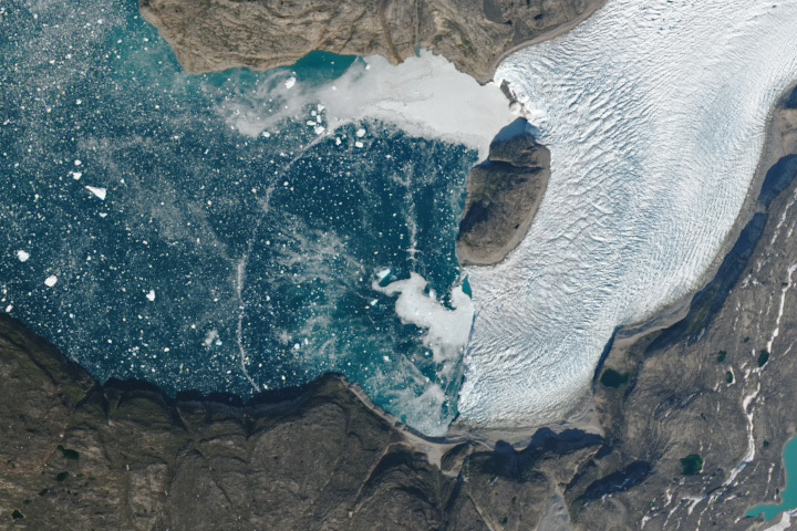
Update on September 26, 2023: This puzzler image shows an ephemeral arc spanning a fjord in Greenland. It may have been caused by a wave from a calving iceberg or an underwater plume of freshwater rising to the surface. Read more about the image in our Image of the Day story.
Every month on Earth Matters, we offer a puzzling satellite image. The September 2023 puzzler is shown above. Your challenge is to use the comments section to tell us where it is, what we are looking at, and why it is interesting.
How to answer. You can use a few words or several paragraphs. You might simply tell us the location, or you can dig deeper and offer details about what satellite and instrument produced the image, what spectral bands were used to create it, or what is compelling about some obscure feature. If you think something is interesting or noteworthy, tell us about it.
The prize. We cannot offer prize money or a trip on the International Space Station, but we can promise you credit and glory. Well, maybe just credit. Within a week after a puzzler image appears on this blog, we will post an annotated and captioned version as our Image of the Day. After we post the answer, we will acknowledge the first person to correctly identify the image at the bottom of this blog post. We also may recognize readers who offer the most interesting tidbits of information. Please include your preferred name or alias with your comment. If you work for or attend an institution that you would like to recognize, please mention that as well.
Recent winners. If you have won the puzzler in the past few months, or if you work in geospatial imaging, please hold your answer for at least a day to give less experienced readers a chance.
Releasing comments. Savvy readers have solved some puzzlers after a few minutes. To give more people a chance, we may wait 24 to 48 hours before posting comments. Good luck!
Tags: Earth, NASA, puzzler, satellites
Humboldt Glacier, Greenland
The image shows a glacier that is part of the Greenland Ice Sheet that flows into the Uummannaq Fjord in the Municipality of Avannata in western Greenland.
It’s located at 70.73422 N -50.65659 E.
I think this picture is in greenland, I think what were looking at is how the ice is melting over a time period. This is interesting becaue it shows us how fast and what exactly is happening to certain areas of the earth.
Possibly a ‘Tidewater Glacier’ or an ‘Outlet Glacier’ in a place like Greenland ?
70.734555,-50.650003 Greenland west coast.
It’s obviously a glacier breaking off into a large bay. I’d guess northern hemisphere and maybe in the area near Alaska
Humbolt Glacier in Greenland
Niagara Falls in Winter
My Wife and I visited in 1993,an amazing spectacle,my only regret was not taking the Helicopter ride.
North Sea saltwater meets the Baltic Sea fresh water in one of the most beautiful natural phenomena of vertical gradient.
A glacier caving icebergs
Johan Petersen fjord in southeastern Greenland
A ‘Tidewater Glacier’ or an ‘Outlet Glacier’ with a Nunatak located in Greenland.
Nunatak
A mountain peak or ridge that pokes through the surface of an Ice Field or a Glacier. It may separate adjacent Valley Glaciers (Greenlandic).
A fjord with a frozen lake somewhere in swede or Norway.
Thé interesting thing is the snow front showing the previous location of thé glacier (or a propagation phénoména)
This appears to be a marine terminating glacier entering a sheltered fjord, which are common in Greenland and Alaska that, say, Antarctica. Assuming the image orientation is with north to the top (which is supported by the shadows on the topography in the lower right corner being consistent with sun to bottom of the image) then the glacier is flowing westward into the ocean, so possibly somewhere in West Greenland. The true color rendition seems too faithful to reality to be be from limited visible bands from VIIRS or MODIS, so I’m going to guess it’s Landsat.
Greenland, Humboldt glacier
Greenland ice melt
The picture shows the late ice melting of the Humboldt glacier in Greenland.
The picture shows the late ice melting of a glacier in Greenland.
Time to time the ice is going back to its beginning…
Uummannaq Fjord GREENLAND
Nearest … (From Wikipedia, the free encyclopedia)
Saattut
Saattut is located in Greenland
Coordinates: 70°48′42″N 51°38′00″W
State Kingdom of Denmark – Avannaata
Uummannaq
Saattut (old spelling: Sâtut) is a settlement in Avannaata municipality, in northwestern Greenland. Located on small Saattut Island, southeast of Appat Island and northeast of Uummannaq in the Uummannaq Fjord system, the settlement had 226 inhabitants in 2020
The satellite image above shows a place located in in the west-northwest parts of Greenland. The main charecteristics of this image is the ice sheet which covers a part on right side (probably a glacier either over land or over sea), while on the left we notice a vast area of melting ice covering the sea.
Also apparent are an area of in-land water (probably a lake) at the down left corner of the image and the shadow of mountains over the south side of the glacier, as well as the shadow of the “hill” at the the end of the glacier over it. Noteworthy are the two areas, one on north and the other on the south of that “hill”, where the ice is thinner than the glasier itself (brighter).
Furthermore, this satellite image was probably aquired by the Operational Land Imager (OLI) on Landsat 8 using the bands 3 or 4 (visible).
Goat Island, Niagara Falls. Ice up river from the falls, free flowing water with ice chunks below and down river from the falls.
This picture is located just east of Qaarsut, Greenland. The image is looking at the Kangigdleq glacier terminus into the Atlantic Ocean, specifically the Uummannaq Fjord, of Baffin Bay. The glacier terminus is just north of the Store Glacier and directly attached to the Greenland Ice Sheet in the Northwest portion of Greenland. Recent years of observations have shown this terminus has retreated.
West Greenland: 70.37766706189855, -50.60299642571958
Interesting ring from calving or an iceberg turning, maybe even a pocket of gas released
Landsat August 3rd image
😉
The picture shows a melting glacier and it seems to be taken from high-resolution imaging satellite like Landsat-8 or Sentinel-2. The surface of the glacier has turned into a mix of snow, dirt and water. What might have formed the ring arc in the middle of the melt water?
It is an image of a glacier, and maybe you are analyzing the melting of glaciers with this image. It is of polar region or any cold region like Alaska or Greenland.
This is the North part of Greenland showing the ice that is melting into the sea.
Looks like Greenland. Interesting because the glacier is receding and dumping ice into the fjord.
A similar feature was observed by me and fellow doctoral-level remote sensing students arcing across the Gulf of St. Lawrence in one of the first images returned from Canada’s Radarsat many years ago. After lots of speculation, the consensus was that it represented a previously unremarked tidal bore. Since tidal bores are not uncommon in that part of the world, why was this new? Again, our consensus was that the bore was probably only about in the cm range, and its continuity clean across the Gulf would not be noticed on the ground, looking like maybe a local ripple. It would also not be noticed ion a visible-infrared satellite or aerial image a there was no real spectral distinction. However the coincidence of cm-scale phenomenon and the sensitivities of the microwave frequencies enhanced the feature into visibility on the image. Might I ask therefore if this LS9 image is within the visible? If so a spectral contrast might be explained by ice being entrained in it? Finally, do you have microwave imagery of the same place and time to shed more light?
I wanted to express my appreciation for the captivating satellite image puzzler you shared in September 2023. These images not only pique our curiosity but also serve as a reminder of the awe-inspiring beauty and mysteries of our planet.
Your commitment to providing intriguing content and engaging your audience is commendable. While I might not have the answer to this puzzler, I thoroughly enjoyed the challenge and look forward to the enlightening explanations that follow.
Thank you for keeping us intrigued and informed.
easy Greenland most likely western greenland