
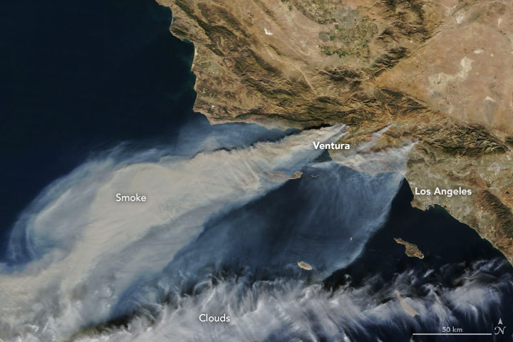
NASA Earth Observatory image by Joshua Stevens, using MODIS data from LANCE/EOSDIS Rapid Response.
With thousands of homes threatened by intense wildfires burning in southern California, NASA Earth Observatory checked in with Jet Propulsion Laboratory scientist Natasha Stavros to learn more about the destructive blazes.
Earth Observatory (EO): Why have these fires been so fast-moving and destructive? Are fierce Santa Ana winds the key factor? Are anomalous temperatures, rainfall, ENSO conditions, bark beetle activity, or other factors playing an important role?
There are absolutely other factors. Santa Ana winds definitely played a role in spreading the fires, but the late fire season is a more complex story. Last year, we had a lot of heavy rains, and this increased fuel connectivity by enabling grasses and annual shrubs to flourish (hence the green hills last spring). However, we had a lot of record-breaking heat waves this year.
In fact, a recent study we conducted with NASA DEVELOP and the National Park Service in the Santa Monica Mountains showed that the number of days over 95 degrees Fahrenheit stressed established vegetation and contributed to massive die-off. Even though the drought is over, the trees are still recovering from the stress of reduced water availability for such an extended period. They are in a fragile state and their defenses are down. This means that they are even more susceptible to infestation, mortality, and ultimately fire danger.
EO: We have published MODIS (top of the page), Sentinel-2 (below), and nighttime VIIRS (bottom of the page) satellite imagery of these fires. Is there anything that you find particularly interesting or notable about these images?
To me, the noteworthy thing is that the plume is going over the ocean and not the continental United States (as we saw earlier this year). This has to do with the Santa Ana winds coming from the desert and pushing particulates, ozone, carbon monoxide, and other toxic pollutants away from where people live.
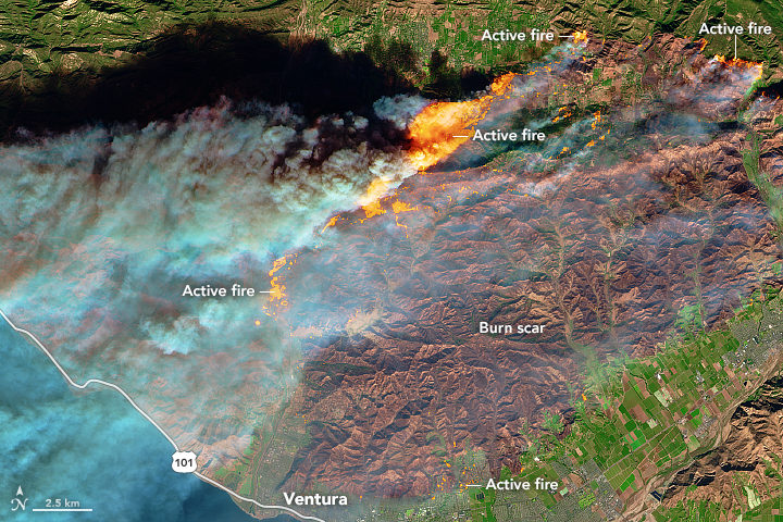
NASA Earth Observatory image by Joshua Stevens, using modified Copernicus Sentinel data (2017) processed by the European Space Agency.
As for the Sentinel-2 image, this is a great shot in that it really shows the value of remote sensing in monitoring fire. Flames that look like that are tens of meters tall. The flame length is proportional to the heat released from the flame, so these fires are very hot. Just like you would not want to stand too close to a bonfire with flames tens of meters tall, fire management does not want to put personnel in the path of those flames.
Images like these and fire behavior models help inform how we think the fire will move across the landscape. There is still a lot we do not know; our models are based on what we do know, so as fires become more intense, the models do not work as well, so this is an area of active research.
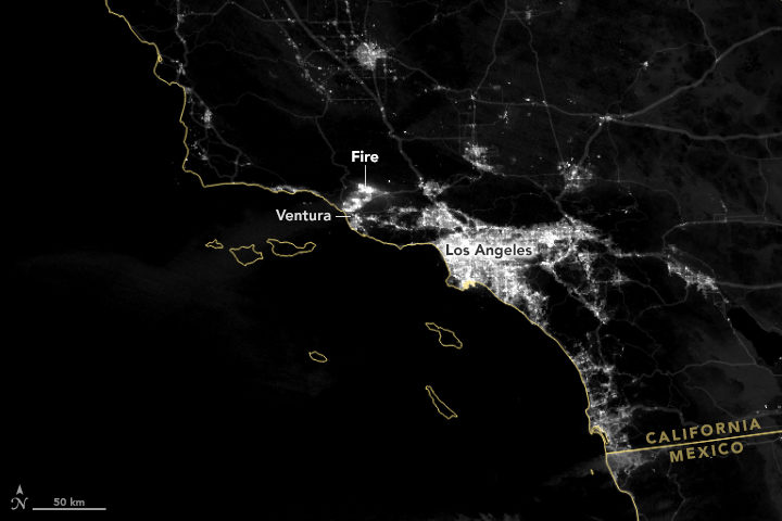
NASA Earth Observatory images by Joshua Stevens using VIIRS day-night band data from the Suomi National Polar-orbiting Partnership.
EO: Is there anything to say about how these fires fit into longer term trends and/or changing climate patterns?
Fire regimes are changing. There is no question about that, and there are a lot of things contributing to it: climate change, a century of fire exclusion, and a growing wildland urban interface (WUI). As we move into the future, we expect there to be an increase in very large fire events. Also, and this is relevant for the events happening now, there will be longer fire seasons. Also, note that many of the fires that ignite close to where people live are actually caused by people. This is particularly true in Southern California.
As we move forward, we need to think about how to support smart fire management practices. By that I mean: what can we proactively do to reduce fire risk (i.e. the threat to valuable resources)?
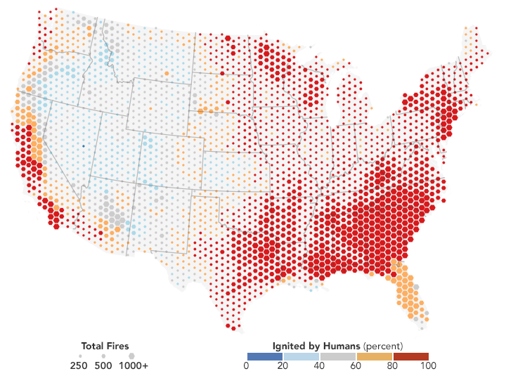
Most fires on the coasts are lit by people. NASA Earth Observatory map by Joshua Stevens, using fire data courtesy of Balch, J. et al. (2017).
EO: What about JPL’s response to these fires? I was intrigued by the megafire project described here. Will your group be responding to this fire in any way?
We just received approval from NASA Headquarters to fly the Airborne Visible/Infrared Imaging Spectrometer (AVIRIS) over these fires. This sensor has been useful for investigating fuel load type and subsequent effects on emission types, fire behavior, and post-fire analysis (e.g., safety, erosion, area burned, fire severity or the amount of environmental change caused the fire, etc.) and is often analyzed in interagency and federal-academic coordination to improve our understanding of fire.
Another effort to support fire management includes work being done from JPL in coordination with the National Interagency Fire Center (NIFC) to help them develop metrics of fire danger using NASA satellites that provide hydrologic variables (e.g., soil moisture and vapor pressure deficit—the difference between the amount of moisture in the air vs how much it can hold). These metrics have a one-month forecast to help allocate fire management resources nationally, which is particularly important as our fire seasons extend throughout the year in multiple places at the same time.

Natasha Stavros. Image courtesy of N. Stavros.
Tags: California, Santa Ana, wildfires
fire started in the hills of South Rosarito beach/ Calafia area of Northern Baja California MX
To Adam and the EO Team ~~ As you state, “We need to think about how to support smart fire management practices.”
There already are significant mitigating strategies available. Sadly, political, civilian and military leaders are reluctant to utilise these life-saving technologies.
I have researched these new tactics for the past 10 years.
Sadly, your reply protocols ask for us not to submit web URLs — this impedes dissemination of such plans.
If you truly are serious about saving lives, businesses, properties and protecting the environment, then take a minute to review my website ~ The Wildfire Hunter.
Copy and paste this link below;
http://www.thewildfirehunter.com/blog/2016/12/12/a-new-paradigm-in-wildfire-combat
Kind regards
Graham Bates
analyst