
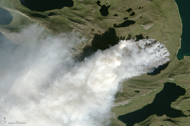
NASA Earth Observatory image by Jesse Allen, using Landsat data from the U.S. Geological Survey. The image was captured on August 3, 2017, by the Operational Land Imager (OLI) on Landsat 8.
Scientists around the world have been using satellites to monitor a wildfire in Greenland. In a place better known for ice, just how unusual is this fire? NASA Earth Observatory checked with Earth science experts Ruth Mottram, Jessica McCarty, and Stef Lhermitte to find out. Mottram is a climate scientist at the Danish Meteorological Institute; Lhermitte is remote sensing scientist at Delft University of Technology; and McCarty is a geographer at Miami University.
How unusual is this fire?
Mottram: Many of my colleagues at the Danish Meteorological Institute (DMI) were a bit surprised at first, but it was clear talking to both the Greenland weather forecasters (they do three month rotations to the airport at Kangerlussuaq) and to some of the older guys that fires do happen reasonably regularly, particularly in the west and south. However, they are not always reported either officially or in the news unless the fire is close to a settlement or affecting shipping or flights. This fire seems to be a fairly large one, but there has been no systematic attempt to gather evidence or data on Greenland’s fires – at least not at DMI. I have never heard of anyone else in Denmark doing it either, so it is a bit hard to be more precise than that.
McCarty: This is a hard question to answer, and I keep telling media reporters the same thing: we need to have the wildfire history analyzed before we know how unusual this is. I can tell you from the global wildfire science community that I am a part of, we would have never thought the we would need to make a wildfire history to understand the fire regime in Greenland. So that part is unusual.
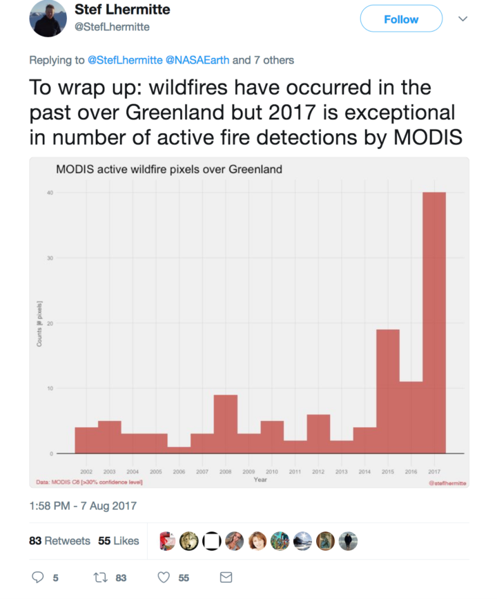
Lhermitte: I completely agree with Jessica. I used to be a wildfire remote sensing scientist (finished my PhD on African wildfires in 2008), but I have shifted since then to the cryosphere community (including some work on Greenland’s ice). It was a big surprise to me to see both worlds combined on Monday when I first noticed a Greenland fire tweet. Now it is clear that fires have occurred before, but that we basically lack a good record. MODIS gives us a glimpse, but the sensor cannot detect fires through clouds, and the record is short. Based on what I have seen, the 2017 fire is the biggest one on the MODIS record, but the record is sparse and incomplete.
I know you have done some looking through MODIS and Landsat satellite data for evidence of past fires in Greenland. What have you found?
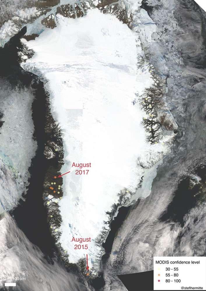
Lhermitte: I looked back at the record of MODIS active fire detections since 2002 and made a quick overview map. In the map below, fire detections are marked with circles. Higher confidence fires are red; lower confidence fires are yellow. In most years, the satellite flags about 5 pixels as having active fires. In 2015, it flagged about 20 pixels. There were over 40 pixels flagged in 2017, so this year has been exceptional. Note: Most of these detections are probably campfires or false detections—not uncontrolled wildfires. There have been two big wildfires: the one happening now and one in August of 2015.
McCarty: Overall, 2017 appears to be a larger fire season than any year since 2001. But from a remote sensing point of view, this is a difficult place to study the fire regime using satellite-based active fire detections (because of cloudiness and other factors). The Landsat/Sentinel-2/Deimos, etc. burn scar images will be more helpful.
Mottram: I have not looked into any of the specific data, but I have heard anecdotes about fires in Narsarsuaq close to the DMI ice service reconnaissance station in the south of Greenland, in the Kobbefjord close to Nuuk, and just to the north of Sisimiut near this one. There was also a large fire in 2008 near Eqi, close to Ilulissat, which the Greenland press reported was caused by a tourist burning rubbish but failing to put the fire out.
One of you said on social media that you think the fire may be burning through peat. Are you sure? How can you tell?
McCarty: The fire line has not moved much in comparison to a wildfire in a grassland or forest. However, Stef made an awesome Sentinel-2 animation that shows the fire line moving some. I still think it is peat with a mix of grasses and moss (given the Google Earth Pro and Deimos imagery), but how deep the peat is difficult to ascertain. A recent study in the Qaanaaq region (north of where these wildfires are) found five times more peat in the soil distribution and soil content than previously reported. Also, historically, peat houses were constructed in this area of Greenland, which means there are peat deposits nearby. Short grasses with underlying peat is my working hypothesis for now since we are onto day 11 of the fire.
Mottram: I am not really a soils expert, and Greenland really suffers from having little detailed mapping of this kind. Also, Greenland is pretty diverse from north to south and east to west. There are high rocky mountains and permafrost. The south has sheep pasture and even some areas of forest; the north has large areas with low vegetation cover. However, there are also extensive areas of peat cite in the scientific literature.
Do you think this fire was triggered by human activity or lightning? Do we know what triggers most fires in Greenland?
McCarty: I still can’t find any indication that this was lightning, so it must be human activity. Greenlandic/Danish news reports are reporting that hikers and tourists should stay from this area, so I would assume that humans are on the landscape there.
Mottram: I can’t really say for sure. Lightning is not impossible, but neither is human activity. It is the middle of the hunting/fishing/berry-picking/hiking season, and this area is known for reindeer. In fact, the Greenland press had an interview with a reindeer hunter who had to turn back from visiting because of the smoke in the fjord. Actually, the hunter wanted the fire put out by the authorities, so he could go hunting there.
What has the weather been like in Greenland during the last few months? Has it been unusually hot or dry where this fire is burning?
Mottram: It has been a very dry summer in the south but also quite dry in this region, and the fire was preceded by some relatively high temperatures. My climatologist colleague John Cappelen tells me that the DMI station at Sisimiut measured an precipitation anomaly of -30.0 millimeters for June and -20.7 millimeters for July compared to the mean precipitation of 1981-2010. In other words, there was almost no rain in June and a bit more than half the usual rainfall in July. There have also been some warm days in Sisimiut (or at least at the airport where the weather station is), particularly towards the end of the month. The monthly average temperature was 7.1 Celsius compared to a 1961-1990 average of 6.3 Celsius in July. The trend has continued into August as well.
This fire got me wondering why there are ice-free areas along Greenland’s coast where vegetation grows. Are these relatively new features? How do you think they got there?
Lhermitte: These ice free coastal areas are mainly the result of the bedrock topography, where the coastal Greenland areas are much more elevated than the interior of Greenland. Since the last glacial maximum, the ice sheet has partly retreated and exposed more land. If the ice sheet would retreat further, we would see more of the inner, lower land exposed.
Mottram: The ice sheet is more or less in equilibrium with the climate, so it is where it is because that is where the glaciers can flow. During the last glacial maximum, the ice sheet extended far out onto the continental shelf and connected (in the north west) with the Laurentide ice sheet in North America. Then, with warming after the last glacial period, the ice sheet retreated. (That is, more ice was melting and calving away than was being replenished by snowfall.) The ice sheet has been more or less stable in its present extent for about the last 10,000 years (with some smaller advances and retreats responding to more local climate variability).
Thank you
Nature fires in Greenland are not unusual. But this fire in August was unusual due to the extent of the fire. But also due to the international awareness to it.
Aqqaluk
How did the fire eventually extinguish? Did officials put it out, or did it burn out on its own? Did precipitation put it out?