
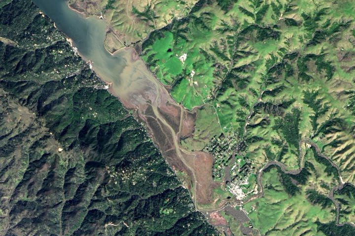
Every month on Earth Matters, we offer a puzzling satellite image. We usually ask you to identify the location of a scene, but that’s not enough this time. For the June 2017 puzzler (above) your challenge is to tell us what the image shows and what makes it interesting.
How to answer. Your can use a few words or several paragraphs. (If possible, try to keep it shorter than 300 words). Tell us the location, but realize we want to hear more than just the location. What features in the image say something about the geological, meteorological, or historical processes that shaped the landscape? What does it teach us about physics or chemistry or biology? How do you think scientists or others might use imagery like this to solve problems and make life better here on Earth? And what do you find notable about this image from a purely visual perspective?
The prize. We can’t offer prize money or a trip to Mars, but we can promise you credit and glory. Well, maybe just credit. Roughly five days after a puzzler image appears on this blog, we will post an annotated and captioned version as our Image of the Day. After we post the answer, we will also update this post and recognize readers who offered the best responses. Please include your preferred name or alias with your comment. If you work for or attend an institution that you want us to recognize, please mention that as well.
Recent winners. If you’ve won the puzzler in the past few months, or if you work in geospatial imaging, please sit on your hands for at least a day to give others a chance to play.
Good luck!
Editor’s Note: Congratulations to Julia H. and Thomas Edwards for being the first readers to solve the puzzler on the Earth Observatory site. Carl Huffman answered first on Facebook. See a labeled version of the June puzzler here.
Looks like an earthquake fault zone. Two different land masses, larger mountains one side due to land being pushed up, smaller more weathered other side. Almost straight edge to left side where as the right side is undulated and irregular.
Possibly the area just NE of Togiak Alaska? Part of the Denali fault line and definitely a sharp change in geology.
Silt laden creek/river flowing into lake due to heavy snowmelt and, exposed soil erosion due to fire scar which would explain the lighter shade of green (new growth) on the NE side of photo
This is the southern end of Tomales Bay, Marin Co., CA with Pt. Reyes Station the built up area on the north, or east, shore (lower right in photo). Tomales Bay sits over a portion of the San Andreas Fault and, as Julie H. notes above, this photo beautifully illustrates an earthquake fault zone.
Classic NW-striking linear feature along a tidally-influenced bay. We are going with the San Andreas fault as it runs along the Tomales Bay through Point Reyes National Seashore. Little town is Point Reyes Station.
Is Tomales Bay at North from San Francisco, California
Image shows San Andreas fault at Point Reyes Station CA. Light green on right is spring grass on cultivated land (dairy farms). Dark green on left is steep forested slope. Tomales bay covers the fault itself.
This terrain looks very much like New Zealand – our country is largely pasture with areas of remnant forest and non-indigenous pine stands. We have a high level of tectonic activity, explaining the clear fault line.
Douglas Island Management Area. Obviously the rivers contribute to some of the water; but it appears to me tidal flow is from the ocean. Fault lines are all over Alaska. I’d say the island on the left is a fault line. Alaska has the second fastest tidal changes in the world. As a kid in Anchorage we’d go down and watch the water recede and return. Captain Cook called Anchorage Anchorage because he had to anchor and turn around. The beach areas are probably silt from a glacial past. Douglas Island is across from Juneau, next to Stephans passage, near Auka Bay and across from Admiralty Island.
This was excellent.
Seems left continental plate contains minerals/metals underground as its coastal line is very straight and brittle. On the other hand right continental plate contains huge deposit of organic matters that is why there is erosion, sediment along the coastal line. These two plates are closing up, eventually jointed by the sediment, I assume residents from the nearby township initially settled this town beside the water but waterline is gradually been push back.
Body of water Tomales Bay … confluence of water,(bay to streams) Near Bivalve ,Town SE of Bivalve= Point Reyes Station.
center of picture approx 38*.05’12.12″N 122*.49’28.86″W… By Landsat 7 ??? ..
The image looks like the Amazon rainforest. The Amazon river is a huge waterway.
The San Andreas fault