Camp managers and other officials overseeing Rohingya refugee camps in Bangladesh are now incorporating NASA satellite observations into their decision-making. Information like daily rain totals can help inform how to lay out refugee camps and how to store supplies. The goal is to reduce the risk to refugees from landslides and other natural hazards.
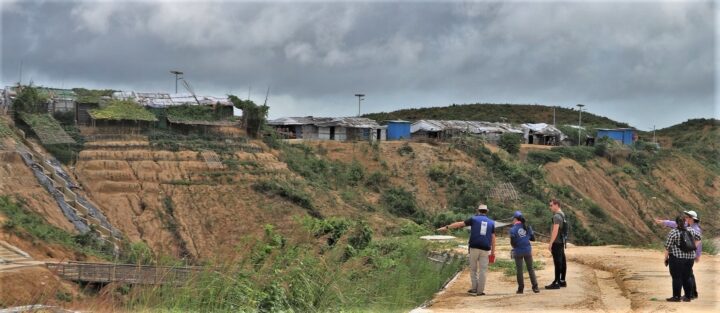
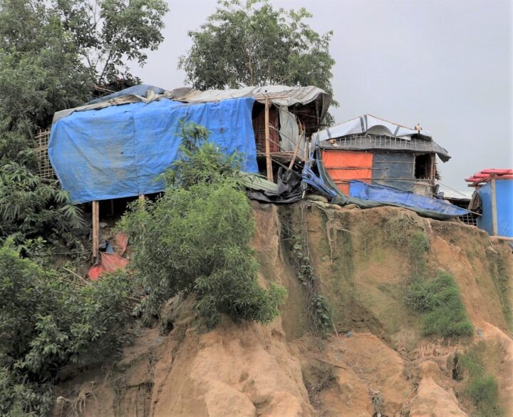
Since August 2017, more than 740,000 Rohingya refugees have fled from Myanmar (Burma) to Bangladesh. Many of them have sought shelter in camps in the hilly countryside, where landslide risks are greatest. When refugee camps were built in the southeastern part of the country, many plants and trees were removed — taking with them the roots that could hold the soil in place and help stabilize the landscape when heavy rains come.
Increasing this danger is Bangladesh’s intense monsoon season. Approximately 80 percent of the country’s yearly rain falls from June to October, bringing with it an increased risk of flash flooding and landslides. For instance, July 2019 storms dropped 14 inches of rain in just 72 hours, causing 26 landslides in Rohingya refugee camps around Cox’s Bazar, Bangladesh. One person was killed and more than 4,500 others were left without shelter.
“We have little information on landslides,” said Hafizol Islam, who is in charge of one of the most densely populated camps at Cox’s Bazar. “It is unpredictable for us and can happen at any time.”
Now Islam and other camp managers have access to maps and a website (updated daily) that provides near real-time NASA data on land use, rainfall, and elevation. Data come from the Global Precipitation Measurement (GPM) mission and the Moderate Resolution Imaging Spectroradiometer (MODIS) instruments on NASA’s Terra and Aqua satellites, among other sources. Taken together, these maps and data provide a clearer picture of when and where landslide hazards are concentrated.
“With landslides, flash floods, and rapid development, the terrain of these camps is constantly changing,” said Robert Emberson, a postdoctoral fellow at NASA’s Goddard Space Flight Center.
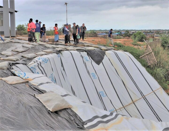
Emberson and other researchers from NASA’s Earth Applied Sciences Disasters Program and Columbia University’s International Research Institute for Climate and Society (IRI) are using new approaches to work alongside humanitarian end-users and develop products to address pressing needs in vulnerable settings. The partnership seeks the feedback of the local people affected and develops maps based on their input.
“We need to understand if, why, and when existing risk information is being used,” said Andrew Kruczkiewicz of IRI, one of the principal investigators of the project. “This strengthens the development of data services for humanitarian emergencies, where decisions and priorities change rapidly. Working in teams that bridge traditional professional and disciplinary boundaries gives data and climate scientists the opportunity to learn more about decision-making in specialized contexts.”
The need for coordination is pressing. Bangladesh has seen steadily increasing rainfall totals over the past 50 years. Climate change is making monsoons in Asia more extreme, and it may be doubling the likelihood of extreme rainfall events even before monsoon season begins.
“The partnership with NASA and IRI helps the UN agencies to assess risks like landslides or flash flooding and supports the disaster management in a scientific way to save lives and reduce damages in the refugee camps,” said Cathrine Haarsaker, a project manager for UNDP Disaster Risk Management.
Emberson said seeing the camps in person brought home the importance of connecting with the people on the ground. “Working with satellite data can sometimes feel quite abstract and separate from the people within the images,” he said. “Visiting the camps not only helped us understand more about the specific problems associated with landsliding to help improve our models in the future, but also drove home the human side to this disaster, emphasizing the urgency of our work.”
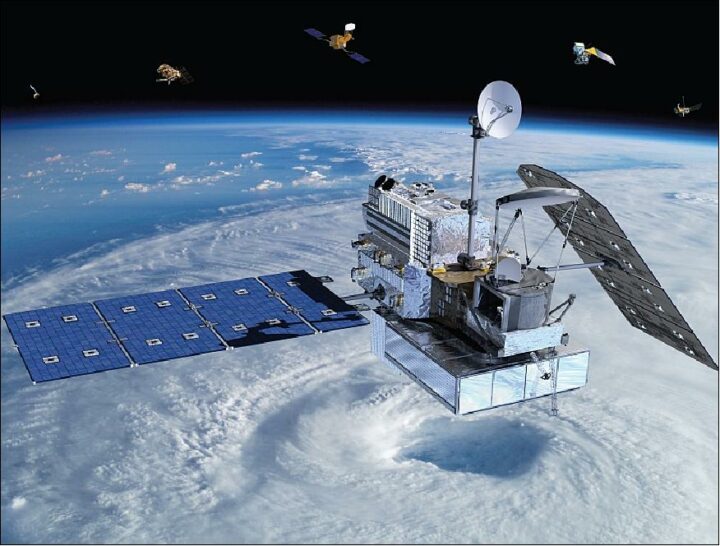
On February 27, 2014, a Japanese rocket launched NASA’s latest satellite to advance how scientists study raindrops from space. The satellite, the Global Precipitation Measurement (GPM) Core Observatory, paints a picture of global precipitation every 30 minutes, with help from its other international satellite partners. It has provided innumerable insights into Earth’s precipitation patterns, severe storms, and into the rain and snow particles within clouds. It has also helped farmers trying to increase crop yields, and aided researchers predicting the spread of fires.
In honor of GPM’s fifth anniversary, we’re highlighting some of our favorite and most unique Earth Observatory stories, as made possible by measurements taken by GPM.
The Second Wettest October in Texas Ever
In Fall 2018, storm after storm rolled through and dumped record rainfall in parts of Texas. When Hurricane Willa hit Texas around October 24, the ground was already soaked. One particularly potent cold front in mid-October dropped more than a foot of rain in areas. By the end of the month, October 2018 was the second wettest month in Texas on record.
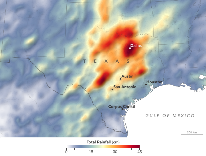
GPM measured the total amount of rainfall over the region from October 1 to October 31, 2018. The brightest areas reflect the highest rainfall amounts, with many places receiving 25 to 45 centimeters (10 to 17 inches) or more during this period. The satellite imagery can also be seen from natural-color satellite imagery.
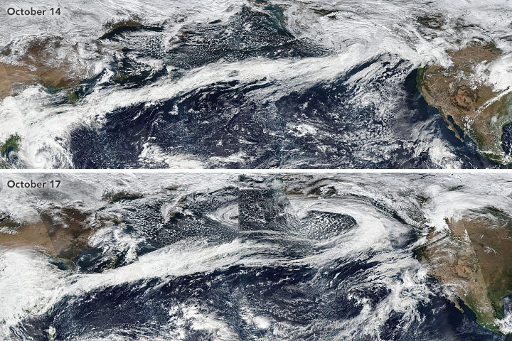
Observing Rivers in the Air
With the GPM mission’s global vantage point, we can more clearly see how weather systems form and connect with one another. In this visualization from October 11-22, 2017, note the long, narrow bands of moisture in the air, known as “atmospheric rivers.” These streams are fairly common in the Pacific Northwest and frequently bring much of the region’s heavy rains and snow in the fall and winter. But this atmospheric river was unusual for its length—extending roughly 8,000 kilometers (5,000 miles) from Japan to Washington. That’s about two to three times the typical length of an atmospheric river.

Since atmospheric rivers often bring strong winds, they can force moisture up and over mountain ranges and drop a lot of precipitation in the process. In this case, more than four inches of rain fell on the western slopes of the Olympic Mountains and the Cascade Range, while areas to the east of the mountains (in the rain shadow) generally saw less than one inch.
Increasing Crop Yield for Farmers in Pakistan
Knowing how much precipitation is falling or has fallen is useful for people around the world. Farmers, in particular, are interested in knowing precipitation amounts so they can prevent overwatering or underwatering their crops.
The Sustainability, Satellites, Water, and Environment (SASWE) research group at the University of Washington has been working with the Pakistan Council of Research in Water Resources (PCRWR) to bring this kind of valuable information directly to the cell phones of farmers. A survey by the PCRWR found that farmers who used the text message alerts reported a 40 percent savings in water. Anecdotally, many farmers say their income has doubled because they got more crops by applying the correct amount of water.
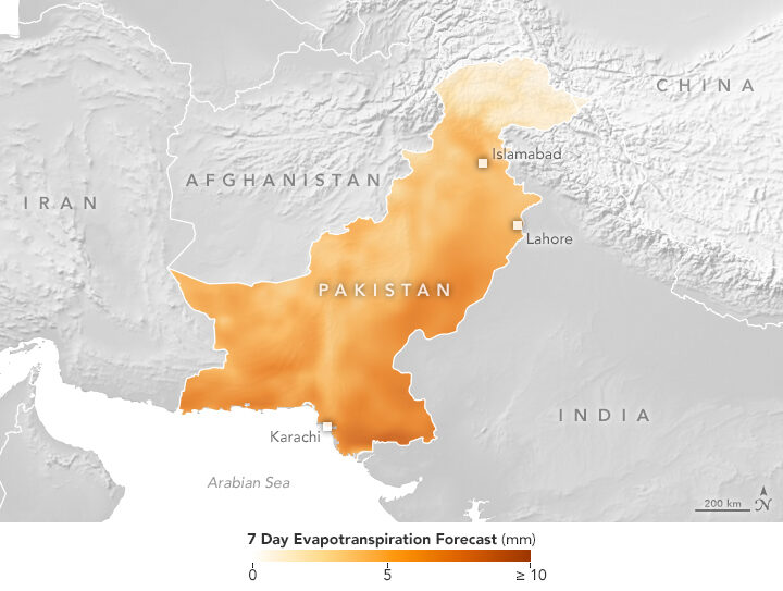
The map above shows the forecast for evapotranspiration for October 16-22, 2018. Evapotranspiration is an indication of the amount of water vapor being removed by sunlight and wind from the soil and from plant leaves. It is calculated from data on temperature, humidity, wind speed, and solar radiation, as well as a global numerical weather model that assimilates NASA satellite data. The team also looks at maps of precipitation, temperature and wind speed to help determine crop conditions. Precipitation data comes from GPM that is combined with ground-based measurements from the Pakistan Meteorological Department.
Forecasting Fire
Precipitation can drastically affect the spread of a fire. For instance, if a region has not received normal precipitation for weeks or months, the vegetation might be drier and more prone to catching fire.
NASA researchers recently created a model that analyzes various weather factors that lead to the formation and spread of fires. The Global Fire Weather Database (GFWED) accounts for local winds, temperatures, and humidity, while also being the first fire prediction model to include satellite–based precipitation measurements.
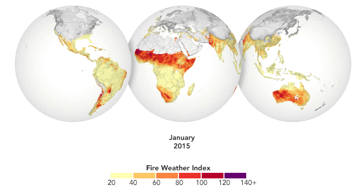
The animation above shows GFWED’s calculated fire danger around the world from 2015 to 2017. The model compiles and analyzes various data sets and produces a rating that indicates how likely and intense fire might become in a particular area. It is the same type of rating that many firefighting agencies use in their day–to–day operations. Historical data are available to understand the weather conditions under which fires have occurred in the past, and near–real–time data are available to gauge current fire danger.
Automatically Detecting Landslides
In this mountainous country of Nepal, 60 to 80 percent of the annual precipitation falls during the monsoon (roughly June to August). That’s also when roughly 90 percent of Nepal’s landslide fatalities occur. NASA researchers have designed an automated system to identify potential landslides that might otherwise go undetected and unreported. This information could significantly improve landslide inventories, leading to better risk management.
The computer program works by scanning satellite imagery for signs that a landslide may have occurred recently, looking at topographical features such as hill slopes.
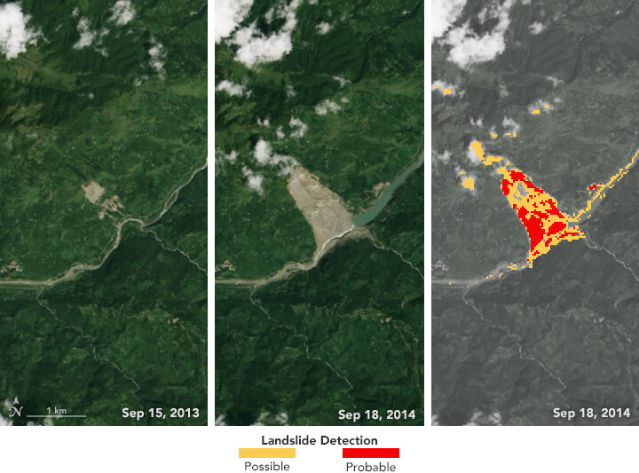
The left and middle images above were acquired by the Landsat 8 satellite on September 15, 2013, and September 18, 2014—before and after the Jure landslide in Nepal on August 2, 2014. The image on the right shows that 2014 Landsat image processed with computer program. The red areas show most of the traits of a landslide, while yellow areas exhibit a few of the proxy traits.
The program also uses data from GPM to help pin when each landslide occurred. The GPM core satellite measures rain and snow several times daily, allowing researchers to create maps of rain accumulation over 24-, 48-, and 72-hour periods for given areas of interest—a product they call Detecting Real-time Increased Precipitation, or DRIP. When a certain amount of rain has fallen in a region, an email can be sent to emergency responders and other interested parties.
The GPM Core Observatory is a joint satellite project by NASA and the Japan Aerospace Exploration Agency. The satellite is part of the larger GPM mission, which consists of about a dozen international satellite partners to provide global observations of rain and snow.
To learn more about GPM’s accomplishments over the past five years, visit: https://pmm.nasa.gov/resources/featured-articles-archive
To learn more about the GPM mission, visit: https://www.nasa.gov/mission_pages/GPM/main/index.html
Atmospheric rivers stretched from Asia to North America in October 2017. Learn more.
If you live on the West Coast of North America, you have probably heard meteorologists talk about “atmospheric rivers” — the narrow, low-level plumes of moisture that often accompany extratropical storms and transport large volumes of water vapor across long distances. When atmospheric rivers encounter land, they can drop tremendous amounts of rain and snow. That can be good for replenishing reservoirs and for quenching droughts, but these remarkable meteorological features can also trigger destructive floods, landslides, and wind storms.
During the past decade, atmospheric rivers have fueled a flood of another type: scientific research papers. Prior to 2004, fewer than 10 studies mentioned atmospheric rivers in any given year; in 2015, about 200 studies were published on the matter. The availability of increasingly sophisticated satellite and aircraft data has fueled the trend, according to a recent article in the Bulletin of the American Meteorological Society. Here’s a sampling of what scientists have learned about these rivers in the sky.
They Can Bring Rains, Winds, And Lots of Damage
In a study led by Duane Waliser of NASA’s Jet Propulsion Laboratory and published in Nature Geoscience, researchers showed that atmospheric rivers are among the most damaging storm types in the middle latitudes. Of the wettest and windiest storms (those ranked in the top 2 percent), atmospheric rivers were associated with nearly half of them. Waliser and colleagues found that atmospheric rivers were associated with a doubling of wind speed compared to all storm conditions.
They Shift With The Seasons
During the winter, atmospheric rivers in the Pacific generally shift northward and westward, Bryan Mundhenk of Colorado State University and colleagues concluded in a study. They also found that the El Niño/Southern Oscillation (ENSO) cycle can affect the frequency of atmospheric river events and shift where they occur. The research was based on data processed by MERRA, a NASA reanalysis of meteorological data from satellites.
They Aren’t Just a West Coast Thing
Atmospheric rivers are a global phenomenon and responsible for about 22 percent of all water runoff. One recent study from a University of Georgia team underscored that the U.S. Southeast sees a steady stream of atmospheric rivers. “They are more common than we thought in the Southeast, and it is important to properly understand their contributions to rainfall given our dependence on agriculture and the hazards excessive rainfall can pose,” said Marshall Shepherd of the University of Georgia. Other studies note that atmospheric rivers have contributed to anomalous snow accumulation in East Antarctica and extreme rainfall in the Bay of Bengal.
Climate Change Could Alter Them
A recent study led by Christine Shields of the National Center for Atmospheric Research suggests that climate change could push atmospheric rivers in the Pacific toward the equator and bring more intense rains to southern California. The modeling calls for smaller increases in rain rates in the Pacific Northwest. Another ensemble of models shows a in the number of days with landfalling atmospheric rivers in western North America.
Satellites Are Key to Studying Their Precipitation
While there are few ground-based weather stations in the open ocean to tally how much rain falls, satellites such as those included in the Global Precipitation Measurement (GPM) mission can estimate precipitation rates from above. “Satellites have proven valuable over both the ocean and land, though uncertainties are often larger over land because of complicating factors like the terrain and the presence of snow on the surface,” said Ali Behrangi, the author of a study that assessed the skill of different satellite-derived measurements of precipitation rates.
A June snowstorm just topped off the already thick layer of white stuff atop the Sierra Nevadas. California’s snow water equivalent rose to a heaping 170 percent of normal. But not so long ago, the state was in the midst of a deep drought; its mountains were bare and brown, and water levels plummeted in reservoirs.
Throughout, satellites were watching. Check out the California drought and its aftermath in a video from NASA Earth Observatory:

Credit: NASA Earth Observatory/VIIRS/Jesse Allen. More details about the image here.
In the past two months, weather reports in California, Oregon, and Washington have been filled with news of “atmospheric rivers” bringing copious amounts of rain and snow to the western United States. Atmospheric rivers are long, thin fingers of moisture that develop in the tropics and flow into higher latitudes. If one of them makes landfall, huge of amounts of rain and snow can fall in a short period.
Much of this moisture, of course, eventually finds its way back to the sea through rivers. When waterways are swollen and flowing rapidly, they also become rivers of suspended sediment, full of clay, mud, sand, and other debris. Though the flooding from atmospheric river events can be devastating, the enormous amount of sediment they send rushing into the sea can also be surprisingly beautiful.
For instance, on February 11, 2017, the Visible Infrared Imaging Radiometer Suite (VIIRS) on Suomi NPP acquired this remarkable view of rivers and streams spewing sediment into the Pacific Ocean. Close to the outlets of streams and rivers, sediment-rich waters appear brown. As the sediment dissipates and mixes into the ocean, the water appears teal.
Duane Waliser, a scientist at NASA’s Jet Propulsion Laboratory, recently tallied just how damaging atmospheric rivers can be for coastal areas. In a study published in Nature Geoscience, Waliser and a colleague showed that atmospheric rivers are among the most damaging storm types in the middle latitudes. Of the very wettest and windiest storms (those ranked in the top 2 percent), atmospheric rivers were associated with nearly half of them. Waliser and colleagues also found that atmospheric rivers were associated with a doubling of the typical wind speed compared to all storm conditions.

Image originally published by NOAA.
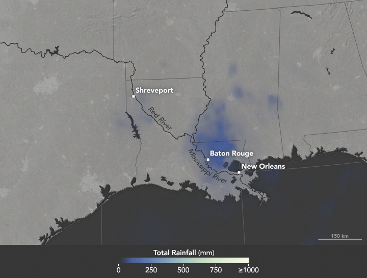
Heavy rains fell on Louisiana in August 2016, causing record-high crests for a number of rivers in the area. Map by Joshua Stevens/NASA Earth Observatory.
In the United States, we say “it’s raining cats and dogs” when we get a heavy downpour. In South Africa, it rains “women with clubs.” In Slovakia, a good soak means “tractors are falling.”
World languages brim with rainy day idioms. But when it comes to describing copious amounts of wet stuff, meteorologists do not encourage wordplay. Researchers are particularly adamant about one expression that does not work: the “rain bomb.”
The summer of 2016 brought extreme rain to multiple parts of the U.S., taking lives and causing billions in property damage. In July, thunderstorms dumped more than six inches of rain on Elicott City, Maryland in roughly two hours, causing flash floods that upended cars and lives. In May, nearly eight inches of rain fell in two days, among a series of heavy rains to inundate Texas. Most recently in Louisiana, more than 30 inches of rain fell in three days, stranding 20,000 people and killing nine.
The Louisiana storm didn’t meet the criteria of a tropical depression as defined by the National Hurricane Center: a tropical cyclone in which the maximum sustained surface wind speed is 38 miles per hour (62 kilometers per hour) or less. In another instance of precise wording, 2012’s Hurricane Sandy technically ceased to be a “hurricane” a few hours before it made landfall, turning into a “post-tropical cyclone.”
For some in the media, “tropical depression” lacks pizzazz and conviction. It lacks the visceral pelting of tractors falling out of the sky or of women with clubs beating down on the Earth. Some news organizations referred to the Louisiana event as a rain bomb. So what should we call severe rain?
NASA scientists George Huffman and Owen Kelley parsed some of the commonly-used rain terminology.
For one, there’s the “rain shaft.” A rain shaft is a centralized column of precipitation—not necessarily heavy rain. “The rain shaft […] is any rain event, no matter how modest or foreboding, that can be seen stretching from the cloud to the ground,” wrote Huffman, a research meteorologist at NASA’s Goddard Space Flight Center.
Then, there are “microbursts.” These are severe wind events caused by a “small column of exceptionally intense and localized sinking air that results in a violent outrush of air at the ground,” according to AccuWeather. Microbursts are smaller than 2.5 miles (4 kilometers) in size.
Be careful of mixing rain shafts with microbursts, Huffman cautioned.
“Just as you don’t have a microburst with every rain shaft, you don’t necessarily have an identifiable rain shaft with every microburst,” wrote Huffman in an email. “The really interesting dynamics of microbursts are a bit rare, and frequently not present in flooding rains.”
There’s also a size distinction between the different systems, NASA scientists said. A rain shaft comes out of an individual convective cell, making it roughly five to ten kilometers across. (By contrast, tropical depressions measure roughly 100 to 500 kilometers across.)
But in some cases, like Louisiana’s, the term “tropical depression” works, said Owen Kelley. “You don’t need to appeal to rain shafts, microbursts, or rain bombs to explain this system,” Kelley wrote in an email. The storm in Louisiana was “just a plain-old tropical depression that got stuck in one place for several days in a row and therefore dumped a lot of rain in one place.” That weather system did display some of the common signs of a tropical system. For instance, Huffman notes that it had low pressure at low and middle altitudes, and high pressure at the top, “implying some degree of warm core.” (Mid-latitude systems have a cold core, with the most negative pressure deviation at the system’s top.)
Researchers agree, though, about one term, “rain bomb,” which appeared in a couple of articles this summer in reference to extreme rainfall events. Don’t use it, scientists said. While it makes for a catchy headline, “rain bomb” is not an established meteorological term.
For extreme rain, Kelley suggested yet another phrase: “vigorous convective cells.” These severe rainstorms can take on various forms: super-cells, squall lines, isolated cells.
Microbursts, rain shafts, vigorous convective cells. At the end, isn’t it all just wet stuff coming out of the sky? Yes and no, scientists say. Terms used to describe extreme rain should be used with an eye on precision. As extreme rains (and extreme weather, in general) become more frequent, so will the terms we use to describe them.
