On February 18, 2021, the Perseverance rover is scheduled to make a historic landing in Jezero Crater on Mars. The rover will survey the area and collect rock samples to send back to Earth. Even though no human has set foot inside the crater, researchers have some ideas of what to expect thanks to a similar landscape on Earth: Lake Salda.
You might not think a lake in southwestern Turkey has much in common with an impact crater on Mars, but the two basins contain similar mineralogy and geology. In fact, Lake Salda is the only known lake on Earth that contains carbonate minerals and depositional features (deltas) similar to those found at Jezero Crater, which is thought to have once contained a lake.

Briony Horgan, a planetary scientist at Purdue University and member of the Perseverance science team, and colleagues from the Istanbul Technical University traveled to Lake Salda in the summer of 2019 to study the shorelines and surrounding area. They aimed to get a better understanding of the microbial and geological processes at Lake Salda to help guide the search for life at Jezero.
Below are photographs taken by Horgan’s graduate student Bradley Garczynski at Lake Salda showing some features that the Perseverance team hopes to find at Jezero Crater.
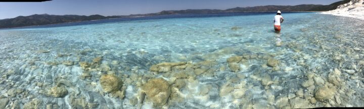
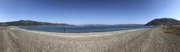
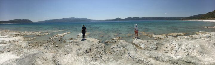
The shoreline and surrounding bedrock around Lake Salda contain sediments of different origins. The photo below shows beach sediments along the northeastern edge of the lake.
The darker-toned sediments were eroded from the steep exposures of the surrounding bedrock. The light-toned sediments are made up of the carbonate mineral hydromagnesite. You can also see the shallow carbonate bench (one to two meters thick) that extends about 40 meters offshore before steeply dropping off to deeper water.
Using data from NASA’s Mars Reconnaissance Orbiter, researchers detected a mixture of watershed minerals and possibly carbonate along the western margins of Jezero Crater, which scientists believe to be the shoreline of an ancient lake. Horgan and colleagues are interested to learn if these deposits are similar to those at Lake Salda.
Researchers are especially interested in the lighter sediments around Lake Salda because they could help inform the search for biosignatures — evidence of past or present life — at Jezero Crater.
The hydromagnesite sediments around Lake Salda are thought to have eroded from large mounds called “microbialites”—rocks formed with the help of microbes. Hydromagnesite sediments may be similar to carbonate minerals detected at Jezero. The photo below shows an exposed island made up of large mounds of old microbialites at Lake Salda.
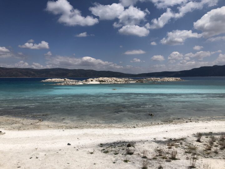
These structures themselves are good indicators that microbes were once active, so researchers will be looking for signs of these in rocks at the Martian crater.
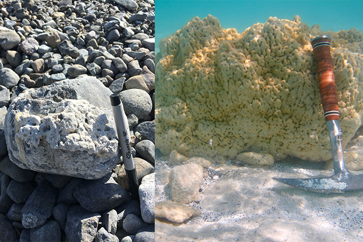
The images below show an older microbialite at Lake Salda that grew on the surface of a rock along the shore of an alluvial fan delta (left) and an underwater image of a modern microbialite at around one meter deep (right). The yellow-green film on the surface is made up of microbial communities that aid in the precipitation of hydromagnesite.
The delta near Jezero Crater adds to the evidence that it once contained a lake. Similarly, Lake Salda contains alluvial fans full of rock deposits eroded and washed down from the surrounding bedrock (shown below). By studying how stones settled in Lake Salda’s alluvial fans, the team can learn more about the depositional processes at Jezero.
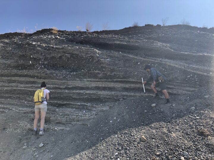
The image below shows an outcrop of sediment deposited by an ancient stream when the water levels were much higher around Lake Salda. The different layers represent different periods of deposition and include various grain types and sizes. The Perseverance rover will look for similar deposits at Jezero to learn more about its geologic history.
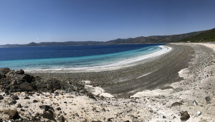
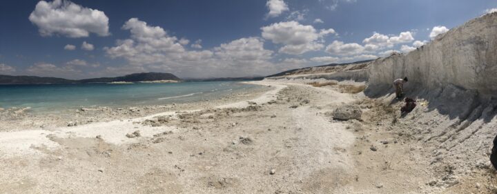
The image below shows a terrace deposit on the southwest peninsula of the lake.
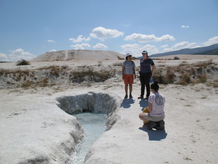
Groundwater springs at Lake Salda (shown below) play an important role in altering the lake chemistry and influencing the environment for microbes.
The image below shows a mud-dominated shoreline on the northeastern edge of Lake Salda. The mud is likely due to a nearby groundwater seep. The darker features just offshore are modern microbialites actively accreting in this muddy embayment.
It is unknown what role groundwater may have played at Jezero. Studying analog environments like Lake Salda helps provide researchers better context while looking for evidence of past groundwater at Jezero and further advance the search for potential biosignatures.
With these observations from Lake Salda, Horgan and her colleagues have been able to better focus their research questions. If microbes existed in the ancient Jezero lake, where did they live and build microbial structures? Where are the best places to search for past evidence of them: near groundwater springs? Near the delta? Or farther away in quiescent shorelines or muddy embayment?
The quest to answer these questions begins this month. Watch the Perseverance landing on February 18, 2021, at 11:15 a.m. PST / 2:15 p.m. EST live here.
Read more about the similarities between Lake Salda and Jezero Crater here.
Special thanks to Bradley Garczynski for helping provide the image descriptions.
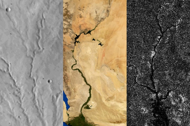
Rivers on three planetary bodies: the dry Parana Valles on Mars (left), the Nile River on Earth (middle), and Vid Flumina on Titan (right). Image by Benjamin Black using NASA data.
One of the more distinctive things about Earth among the planets is that we have plate tectonics. In other words, the hard, outer shell of the planet (called the lithosphere) is divided into several cool, rigid plates that float atop a hotter, more fluid layer of rock (the asthenosphere). These rigid surface plates do not float placidly: their grinding, colliding, shifting, and diving causes earthquakes, fuels volcanoes, builds mountains, tears open oceans, and constantly remodels and resurfaces the planet.
That is a far cry from what is happening on Mars and Titan, according to a recent study published in Science. Researchers came to that conclusion by carefully analyzing the way rivers cut through each of these planetary bodies. On Earth, countless rivers and streams snake their way across the surface. On Mars, rivers dried up long ago, but evidence of their presence remains etched into the arid surface. On Titan, Saturn’s largest moon, rivers of liquid ethane and methane still flow into lakes.
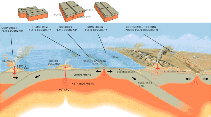
Artist’s cross section illustrating the main types of plate boundaries on Earth. (Cross section by José F. Vigil from This Dynamic Planet—a wall map produced jointly by the U.S. Geological Survey, the Smithsonian Institution, and the U.S. Naval Research Laboratory.)
By comparing imagery and data from all three planetary bodies, researchers noticed distinctive bends in the courses of rivers on Earth; these were formed as rivers were forced to wind around mountain ranges. These bends were absent in river networks on Mars and Titan. In an MIT press release, Benjamin Black, a geologist at the City College of New York, explained:
“Titan might have broad-scale highs and lows, which might have formed some time ago, and the rivers have been eroding into that topography ever since, as opposed to having new mountain ranges popping up all the time, with rivers constantly fighting against them.”
Read more about the study from New Scientist, Space.com, and the American Association for the Advancement of Science. Read the full study in Science. Read this NASA Earth Observatory story to learn more about how scientists are using satellites to study river width on Earth.
In the triptych at the top of the page, the image of Parana Valles on Mars was acquired by the Viking 1 orbiter on September 13, 1976. The image of the Nile was captured by NASA’s Terra satellite on August 10, 2000. NASA’s Cassini spacecraft captured the image of Vid Flumina on Titan on September 26, 2012.
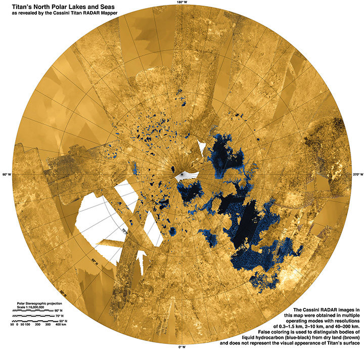
While water does not flow on Titan, rivers of methane and ethane flow into lakes near the moon’s northern pole. Learn more about this image from the NASA Jet Propulsion Laboratory Photojournal.
