Clouds are an important part of the climate system. They affect how much sunlight reaches the ground and how much heat returns to space, which in turn affects Earth’s temperature and rainfall patterns. Scientists are working to better understand the role that clouds play in the global climate system, but that requires significant amounts of data.
“No single cloud observation method or system … is able to provide a complete and accurate depiction of cloud properties across the Earth under the many conditions that naturally occur,” said Bill Smith, an atmospheric scientist at NASA’s Langley Research Center (LaRC). Cloud observations are gathered by active and passive satellites, ground-based sensors, and, by humans.
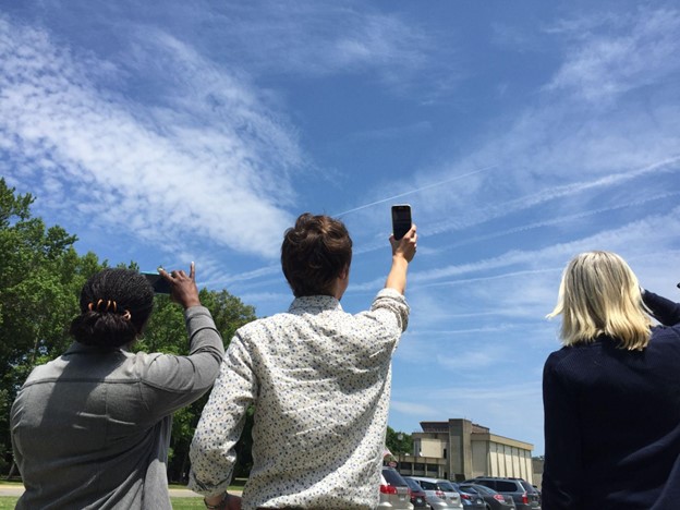
The citizen scientists of the GLOBE Program have been playing a vital role in data collection by observing clouds around the globe, especially at times that “match” a satellite flyover. When that happens, the observations from the citizen scientists on the ground are matched with satellite observations that were made near the same time and place. By combining the ground-up view of GLOBE citizen scientists with the top-down view of satellites, scientists get a more complete view of the atmosphere.
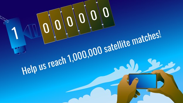
Now, the NASA GLOBE Clouds team is hoping to hit a significant milestone: one million matches by the time of the GLOBE annual meeting in late July 2022.
When a GLOBE cloud observation is taken within 15 minutes of a satellite observation, both points of view are coupled, creating a match. Some satellites are geostationary satellites, such as GOES, Himawari, and Meteosat. Others are polar-orbiting satellites, such as Aqua, Terra, and CALIPSO. The satellite-matched data provides an augmented dataset for research. When a match is made, the NASA GLOBE Clouds team sends a personalized email to participants with the matching satellite data. Approximately 4,000 emails are sent to participants each month.
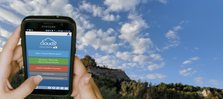
Participants who want to help GLOBE meet their million-match goal this July can photograph clouds, then upload the photographs and classify the clouds using the GLOBE Observer app. Visit the GLOBE Observer website to learn more about the Match to a Million campaign and how you can help NASA learn more about Earth’s atmosphere.
Read more about the value of combining ground and space measurements in the GLOBE blog Counting to a Million Matches and learn more about matching to satellites on the GLOBE Clouds Science page. You can also follow GLOBE on social media and share what you’re doing to help GLOBE match to a million by using the hashtag #GLOBE1M .
The NASA-funded Global Learning and Observations to Benefit the Environment (GLOBE) program was launched on Earth Day in 1995. Over the past 27 years, millions of students in more than 120 countries have collected and entered more than 200 million environmental measurements into the GLOBE database. Those observations include surface temperatures, rainfall amounts, tree heights, land cover, mosquito habitats, and a variety of other environmental observations, including cloud type and coverage.
The NASA-sponsored Global Learning and Observations to Benefit the Environment (GLOBE) Program has received the American Geophysical Union (AGU) 2021 Excellence in Earth and Space Science Education Award. According to AGU, the annual award honors an individual, group, or team committed to promoting excellent geophysical education.
Through GLOBE, people around the world learn how to document and share useful information about their local environment with scientists. Launched on Earth Day in 1995, GLOBE connects scientists, teachers, and students in 126 countries with hands-on scientific activities.
“GLOBE is a phenomenal program that has a special place at NASA,” said Dr. Allison Leidner, program manager for education and communication in the Earth Science Division of NASA’s Science Mission Directorate. “Enabling students and citizen scientists to investigate our home planet gives them a greater appreciation of our environment, ignites their interest in science-related careers, and connects them to the international Earth science community. We are so happy to see AGU recognize GLOBE with this award.”
Through teachers that have been trained in GLOBE protocols, students learn how to conduct scientific investigations and collect data in their community. GLOBE science protocols were developed with Earth scientists and many protocols have connections to NASA’s satellite missions. So far, GLOBE participants have gathered and shared more than 200 million Earth science observations.
“The GLOBE Program has made outstanding achievements and contributions by pushing the frontiers of our science forward,” said AGU President Susan Lozier in a statement, on behalf of the AGU Earth and space science community. “GLOBE has also embodied AGU’s shared vision of a thriving, sustainable and equitable future for all, powered by discovery, innovation, and action. And you did this with integrity, respect, diversity, and collaboration while creating deep engagement in education and outreach.”
In addition to being sponsored by NASA, GLOBE is supported by the National Science Foundation (NSF), National Oceanic and Atmospheric Administration (NOAA), and the U.S. Department of State.
Dr. Tony Murphy, GLOBE Implementation Office director, and Dr. Caryn Long, middle school science teacher at Montverde Academy (Florida), share more about the program and its recent recognition. Their responses have been edited for clarity.
Tony Murphy: GLOBE has a strong community of citizen scientists, students, and teachers all over the world who are eager to contribute to Earth system science research. GLOBE allows people to contribute to data collection and submission, to understand the scientific research process and the work of scientists, and to see how their local environment fits into the regional and global environment.
Caryn Long: I have used GLOBE in my classroom for five years now. GLOBE is different from other science education programs because it educates students while also immersing them in the practical and applied nature of science. Knowing they are contributing to real research with NASA scientists is a powerful motivational tool to get them to practice the skills of observation, data collection, and analysis in a real and meaningful way. They want to practice the skills they are developing because what they are doing is valued.
Long: Our classroom participates in the Cloud, Aerosols and Hydrology Protocols and the Surface Temperature Field Campaign at the lake behind our school. We are adding more protocols each year. Each time I share with my students that we are learning a new protocol to add to their toolbox, they are excited to get started. What my students have enjoyed most about GLOBE is meeting some of the scientists that are involved with the program. Another highlight for them is gathering the cloud data because it involves NASA satellites. Receiving the email matches with the satellites is exciting to the kids because they love comparing what they saw from a ground level to what the satellite has viewed.
Murphy: Seeing students communicate their research at meetings, and especially at the two GLOBE Learning Expeditions I have attended, has been truly amazing. GLOBE Learning Expeditions are week-long, student-focused events held every few years at sites around the world. I gave a scientific presentation at a national science competition in Ireland when I was in middle school. That experience had a major influence on my life, so it’s incredible to see so many GLOBE participants have a similar opportunity.
Murphy: The GLOBE community has grown tremendously from a small number of countries in 1995 to 126 countries today with a database of over 200 million measurements for use in research by students and scientists. New technology advancements including the GLOBE Program’s app, GLOBE Observer, have impacted the ways in which the program is implemented and enables citizen scientists to participate. The GLOBE community worldwide, including students, country coordinators, teachers, program support staff, government officials, and program sponsors, have allowed GLOBE to earn this recognition.
Through May 15, 2021, the GLOBE Program is hosting the 2021 Trees Community Challenge, a project aimed at making science better together by encouraging participants to collect data and learn about trees.
Using the Trees Challenge Activity Tracker, participants can pick and choose activities – or complete all of them – to become members of the NASA citizen science community. Activities include taking a tree height observation, writing a tree poem, and sharing stories about trees that are special to you on social media
Trees are diverse and tree height can tell us a lot about Earth’s ecosystems. Satellites and ground-based measurements are used to track tree growth, monitor how well an ecosystem supports trees, and estimate how much carbon is stored by trees. The GLOBE community encourages #CitizenScientists to use the GLOBE Observer app to take tree height measurements with their smartphones.
Read more about the challenge and how to participate.
Trees connect us scientifically, environmentally, and culturally. We all know that trees are vital to our planet’s health. As trees grow, they absorb carbon from the atmosphere, playing a vital role in Earth’s global carbon cycle and helping to regulate Earth’s carbon budget.
But before you read any further, look around…especially if you are outside. Most of you can look in any direction and see a tree. You might wonder about a few things like: “What type of tree is that?” or “Why is that tree so tall or short?” or “How old is that tree?” or even “Was that tree planted by someone, or did the wind blow a seed to where the tree is now standing?”
Or what if you don’t see any trees? What does that signify about the environment? Did nature make it that way, or did humans? All of these are great questions that can help us understand and connect with the environment.
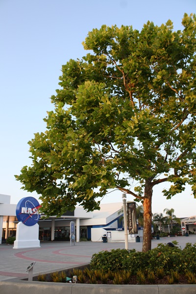
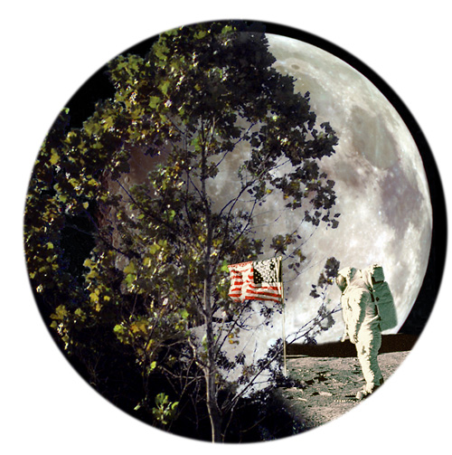
A few trees on Earth also connect us to the Moon. Have you ever heard of “Moon Trees?”
“Moon Trees” never actually grew on the Moon, but their seeds were taken into lunar orbit 50 years ago this week. The NASA Moon Trees history website explains:
Apollo 14 launched in the late afternoon of January 31, 1971, on what was to be our third trip to the lunar surface. Five days later, Alan Shepard and Edgar Mitchell walked on the Moon while Stuart Roosa, a former U.S. Forest Service smoke jumper, orbited above in the command module. Packed in small containers in Roosa’s personal kit were hundreds of tree seeds, part of a joint NASA/USFS project. Upon return to Earth, the seeds were germinated by the Forest Service. Known as the “Moon Trees,” the resulting seedlings were planted throughout the United States (often as part of the nation’s bicentennial in 1976) and the world. They stand as a tribute to astronaut Roosa and the Apollo program.
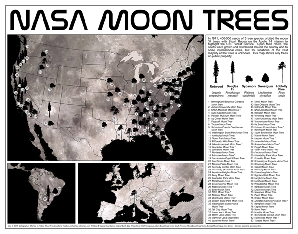
Among the Moon Trees that were eventually planted around the United States and the world were sycamores, Loblolly pines, redwoods, sweetgums, and Douglas firs. Though it is unlikely the Moon Tree seeds were changed much by their brief lunar orbit, it is still a wonder that they made it into space and back, and that many of the trees are growing and thriving today.
So, where can you find them? The NASA Moon Trees site has a list, and there is also an article and photographs from our friends at National Geographic. UC Davis data scientist Michele M. Tobias created the map below. You can also learn more about the trees from our colleagues at Marshall Space Flight Center.
Perhaps you might see some Moon Trees in person in the next year or two. If you do, consider making tree height observations using the tree tools on the NASA GLOBE Observer app. When completing your observation, let us know in the app.
Have you ever visited and seen a Moon Tree? Tell us about it below.
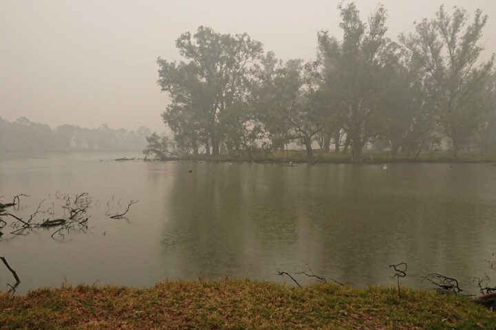
As satellites track Australian wildfire smoke from above, GLOBE Observer citizen scientists have been keeping tabs on hazy skies from the ground.
The photograph above shows smoke blanketing Horseshoe Lagoon in New South Wales on January 6, 2020, a day when clouds limited what sensors on Terra, Aqua, and Suomi NPP could observe as they passed over.
The video below, based on photographs taken by GLOBE citizen scientist Glenn Evans, juxtaposes satellite images and photographs taken of the sky at roughly the same place and time. The contrasting perspectives underscore how easy it can be to miss the forest for the trees — or, rather, the smoke plume for the clouds — if you aren’t careful. Kristen Weaver, the deputy coordinator for GLOBE Observer, compiled the photos and matched them with the corresponding MODIS satellite images.
Victoria and New South Wales are in the midst of one of the most severe fire seasons either state has seen in decades. After months of unusually hot, dry weather, hundreds of fires have charred an area larger than West Virginia, destroying thousands of homes and resulting in dozens of deaths.
GLOBE Observer is a citizen science project that is part of the Global Learning and Observations to Benefit the Environment (GLOBE) Program. Through a free app for their mobile device, anyone in participating countries can make environmental observations of clouds, trees, land cover, and mosquito habitats that complement NASA satellite observations.
Who knew that being a scientist could be as easy as pointing your phone at the sky? This month, NASA and the GLOBE Program are asking citizen scientists to take out their phones and report what kinds of clouds they see above them.
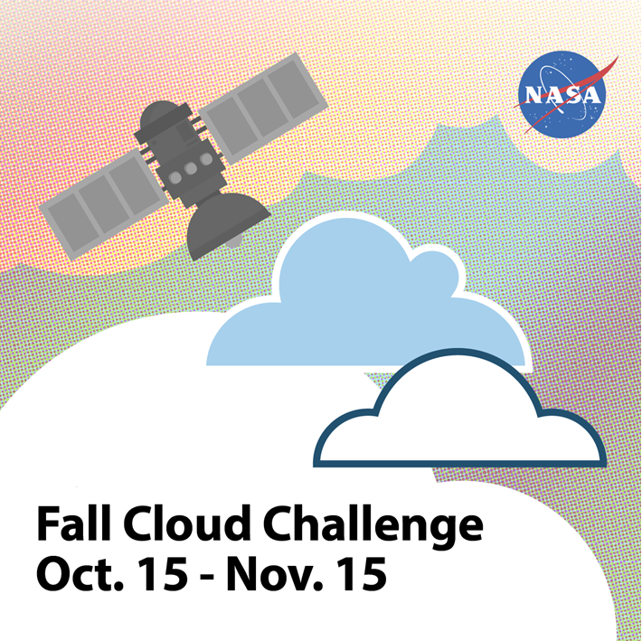
From October 15 to November 15 citizen scientists young, old, and in-between can submit up to ten cloud observations per day using the GLOBE Observer app or one of GLOBE’s other data entry options (for trained members). Participants with the most observations will receive a personalized thank you from a NASA scientist.
“What excites researchers about GLOBE observations is the ability to see what’s up in the sky from volunteers’ perspectives all over the world,” said Marilé Colón Robles, lead for the GLOBE Clouds Team at NASA’s Langley Research Center. “What our eyes can see is difficult to fully duplicate with instruments. Merging these views is what makes a complete and impactful story.”
“We want to do a data challenge in the fall and see if there are any differences from what was observed during the spring data challenge of 2018,” said Colón Robles. “From thin, high clouds that are hard for satellites to detect to dust storms that impact our daily lives, these observations play an important role in better understanding our atmosphere.”
At NASA, scientists work with a suite of satellite instruments known as the Clouds and the Earth’s Radiant Energy System (CERES). Though they have these highly sensitive instruments, it can sometimes be difficult for scientists to distinguish features such as cirrus clouds from snow cover in their imagery because both are cold and bright from a satellite perspective. By comparing satellite images from a particular area with data submitted by citizen scientists, researchers can differentiate between the two.
Lucky GLOBE observers might make an observation while the Cloud-Aerosol Lidar and Infrared Pathfinder Satellite Observation (CALIPSO) is overhead. CALIPSO is a joint mission between NASA and the French space agency (CNES) that uses laser pulses to measure clouds and atmospheric aerosols. Citizen scientists who make observations at the same time and place as CALIPSO will receive an emailed satellite comparison of CALIPSO’s measurements showing features such as high clouds, dust, and smoke. Scientists are especially interested in these observations in order to improve their understanding of dust storms. During the challenge, make sure you turn on daily satellite notifications in the app or use this satellite overpass website to see the schedule for your location.
“Last year’s challenge gave researchers special glimpses into cloud types around the world,” said Colón Robles. “Photographs provided by observers gave insight into events such as dust storms and wildfires. Our hope is to once again learn from the community and together study our atmosphere.”
The 2018 data challenge, which took place in the spring, received more than 56,000 cloud observations from more than 15,000 locations in 99 countries and Antarctica.
NASA is a sponsor of GLOBE, an international science and education program that provides students and the public with the opportunity to participate in data collection and the scientific process. NASA GLOBE Observer is a free smartphone app that lets anyone make citizen science observations from the palm of their hand.
Cloud Identification Resources and Tips
Data collection and data entry help
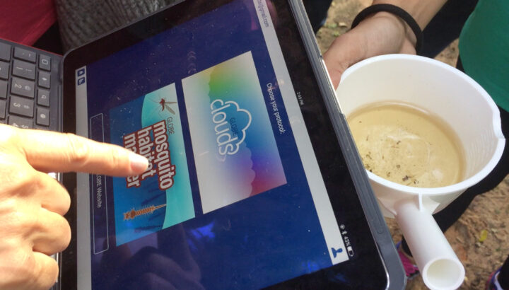
Join a mosquito mapping blitz for Citizen Science Day through GLOBE Observer.
Earth observations take place on many spatial scales. Some observations originate from sensors in space; others can happen with a mobile phone in the palm of your hand. GLOBE Observer is a free mobile app that connects an international network of citizen scientists with the broader scientific community in an effort to document and analyze changes taking place in Earth’s air, land, water, and life. The app is the centerpiece of a citizen science blitz now underway.
Both globalization and a changing climate have caused countless living creatures to adjust their range and distribution. For human health, one of the most concerning impacts of a changing climate is the range expansion of mosquitoes. These flying vectors of disease are responsible for illness in millions of people; they also cause more than 700,000 deaths each year.
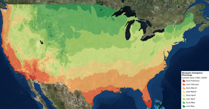
The northern hemisphere is now greening up in response to changes in sunlight and temperatures, and mosquito season is either just beginning or underway in much of the contiguous United States. The map above indicates when the first appearance of mosquitoes can be expected based on past weather data. The actual time of first appearance in a region can vary by several weeks, depending on the weather and other variables.
The GLOBE Observer app has a new tool known as the Mosquito Habitat Mapper, which makes it possible for citizen scientists to observe, record, and share data about mosquito breeding sites using a mobile phone. The data are important to scientists trying to predict disease outbreaks and epidemics. Observations provided by citizen scientists, combined with satellite observations and models, can make it possible to track the range and spread of invasive mosquitoes.
With the Mosquito Habitat Mapper, citizen scientists can report active and potential breeding sites in their communities. And using a built-in taxonomic key, GLOBE Observers can help determine whether the mosquito larvae have the potential to transmit disease pathogens to humans.
GLOBE Observers also can have an immediate impact on health in their community. In the last step of Mosquito Habitat Mapper, users report whether they were able to remove a breeding site. This can be accomplished in most cases by simply tipping and tossing standing water that is found in containers, or by covering stored water with a net or a lid. For larger water bodies such as ponds, irrigation ditches, or swamps, the reports about breeding sites can be used by mosquito surveillance agencies.
In this way, GLOBE Observers are not only engaged scientifically, they can become agents of change in their community. The World Health Organization (WHO) identifies source reduction–the elimination of mosquito breeding sites–as the most effective way to protect human populations and reduce the threat of mosquito vector-borne disease.
The GLOBE Observer Mosquito Blitz kicked off on April 7, 2019, and ends on Citizen Science Day (April 13). Join in this effort by downloading the app. Follow GLOBE Observer on social media during Mosquito Blitz week on Facebook or Twitter. Check out the Mosquito Blitz website and GLOBE Mission Mosquito for more mosquito resources.
