
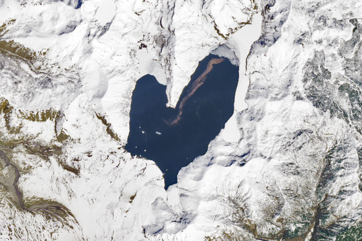
Update on March 11, 2024: This image shows Spirit Lake, located in south-central Washington, on April 26, 2023. Congratulations to Ivan Kordač for being the first to correctly identify the lake. Special mention goes to David Sherrod, who pointed out the lake’s floating log raft and mentioned a recent debris flow in the region (which occurred several weeks after this image was acquired). Read more about the lake in our Image of the Day story.
Every month on Earth Matters, we offer a puzzling satellite image. The February 2024 puzzler is shown above. Your challenge is to use the comments section to tell us where it is, what we are looking at, and why it is interesting.
How to answer. You can use a few words or several paragraphs. You might simply tell us the location, or you can dig deeper and offer details about what satellite and instrument produced the image, what spectral bands were used to create it, or what is compelling about some obscure feature. If you think something is interesting or noteworthy, tell us about it.
The prize. We cannot offer prize money or a trip on the International Space Station, but we can promise you credit and glory. Well, maybe just credit. Within a week after a puzzler image appears on this blog, we will post an annotated and captioned version as our Image of the Day. After we post the answer, we will acknowledge the first person to correctly identify the image at the bottom of this blog post. We also may recognize readers who offer the most interesting tidbits of information. Please include your preferred name or alias with your comment. If you work for or attend an institution that you would like to recognize, please mention that as well.
Recent winners. If you have won the puzzler in the past few months, or if you work in geospatial imaging, please hold your answer for at least a day to give less experienced readers a chance.
Releasing comments. Savvy readers have solved some puzzlers after a few minutes. To give more people a chance, we may wait 24 to 48 hours before posting comments. Good luck!
46.272842, -122.146401
Where is the wood of spirit lake?
Under the snow or water also?
Thank you very much for that picture
Ivan Kordač Prague CZECH Rep.
Vertical view of Spirit Lake, which sits just north of Mount St Helens. North is up, more or less. The grayish mass at the north end of the northeast arm of the lake is probably snow-ice cover on the remnant mass of logs that once covered much of the lake. (Their brethen have become waterlogged and subsided beneath the surface.) Unsure of the date of the image, but the road to Johnston Ridge Observatory (JRO) shows in the drainage on the west side of the image. The image may predate the autumn mudflow that has closed that road and will leave it closed for a year or more. If the image is recent (this winter’s), then the damage, while still an engineering nightmare, isn’t as extensive as I might have presumed.
Looks like snowmelt lake in Greenland and maybe the brown track is evidence of a road or dirt from cave or something exposed under the melt. That water has to be freezing so I doubt any sort of algae.
What I might call the “cuff of the mitten” at the lower end of this lake seems to have some odd slumping of the earth and snow, probably changing the outflow of the lake — and perhaps forming the lake.
I’m going to guess that this lake was formed by the January 1, 2024, 7.6 magnitude earthquake on the Noto Peninsula of Japan.
The purplish band in the top right part of the lake is probably sediment broken loose into the primary inflow of the lake.
This picture looks like a giant dropped her mitten.
Faroe Islands
Lake Ohrid, the town Ohrid
Image Landsat Copernicus of Porisvan/Icelandia
A area in Norther Central Iceland Dorisvan probably taken from Landsat Copernicus satellite
The image is of an area of melting ice in Antarctica that is creating questions about underground geothermal currents that are accelerating the receding ice in the South Pole.
It looks like the top of a (potentially Alpine) glacier that has melted instead of being made of ice.
No idea where this might be.
This is my first entry: I love this puzzle.
THANK YOU!
Thierry
This is Spirit Lake, which lies just north of Mount St. Helens in the Mount St. Helens National Volcanic Monument in the state of Washington. It is interesting due to the ‘smear’ of brown material on its surface. This smear is actually a raft of floating logs dating from the May 1980 eruption of the volcano. The raft was created by the one-two punches of a massive landslide and pyroclastic flows that both raised the level of Spirit Lake and created tsunamis that scoured its shores of blown down trees. The raft was initially much larger and covered a greater percentage of the lake. Many logs have since rotted and sunk to the bottom and the location of the existing raft reflects prevailing winds in the area.
Spirit Lake just north of Mt. St. Helens. The brown swatch is probably a log raft from blown-down trees. The curved lake shore at the bottom of the lake appears to be an alluvial fan from the eruption of the the mountain.
This one was easy because I recognized the shape of the lake. That is Spirit Lake just north of Mt. St. Helens in Washington State, USA. One can still see the floating log debris.
As for the sensor, it looks to be optical and a little blurry so maybe Landsat or Sentinel.
From the Geospatial Pixel Pusher who is the remote sensing advisor to a non-profit GIS group – SharedGeo.
Iceland
a lake on the top of the iceshield
We are looking at a lake in Greenland
I agree with the Greenland – it is in the NE part of Greenland – a subglacial lake : Flode Isblink ice cap.
I’m going with Spirit Lake.