
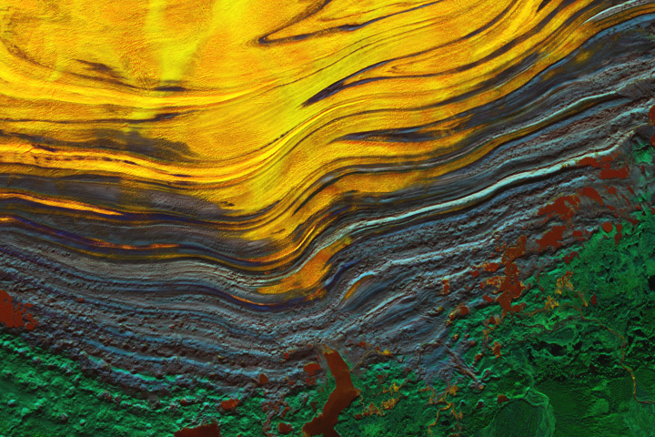
Update on November 27, 2023: This false color image shows the terminus of southeastern Alaska’s Malaspina Glacier, the largest piedmont glacier in the world. Congratulations to Juan Antolin Arnau for being the first to correctly identify the feature and its location. Read more about the image in our Image of the Day story.
Every month on Earth Matters, we offer a puzzling satellite image. The November 2023 puzzler is shown above. Your challenge is to use the comments section to tell us where it is, what we are looking at, and why it is interesting.
How to answer. You can use a few words or several paragraphs. You might simply tell us the location, or you can dig deeper and offer details about what satellite and instrument produced the image, what spectral bands were used to create it, or what is compelling about some obscure feature. If you think something is interesting or noteworthy, tell us about it.
The prize. We cannot offer prize money or a trip on the International Space Station, but we can promise you credit and glory. Well, maybe just credit. Within a week after a puzzler image appears on this blog, we will post an annotated and captioned version as our Image of the Day. After we post the answer, we will acknowledge the first person to correctly identify the image at the bottom of this blog post. We also may recognize readers who offer the most interesting tidbits of information. Please include your preferred name or alias with your comment. If you work for or attend an institution that you would like to recognize, please mention that as well.
Recent winners. If you have won the puzzler in the past few months, or if you work in geospatial imaging, please hold your answer for at least a day to give less experienced readers a chance.
Releasing comments. Savvy readers have solved some puzzlers after a few minutes. To give more people a chance, we may wait 24 to 48 hours before posting comments. Good luck!
Vemos la lengua del glaciar Malaspina, al oeste de la bahía de Yakutat, en Alaska
En la imagen se han utilizado longitudes de onda infrarrojas
Looks like a false color image of the terminus of the Malaspina Glacier in Alaska. The flow rate of the ice drops as the ice moves away from the mountains, so the ice folds. As it stagnates, tress can grow on soil covering the ice.
Malaspina Glacier, Gulf of Alaska
Looks like Malaspina Glacier in Alaska.
Simpson Desert in Queensland near Birdsville
With only a little experience from school, my guess is the following: This image is a satellite altimetry image of sea floor, showing the crustal warping. It is interesting because there are three types of warping. Green is hard earth crust, yellow is softer crust (maybe some thin crust). The grey crust warps as it compresses between the forces.
Edge of Malaespina Glacier (Alaska)
In the combination of bands used, the clean ice is yellow, the moraine is bluish, the lakes are maroon and the possible tundra is green.
It looks to me like layered buildup of deposits, like an alluvial fan (or river emptying into the ocean) taken with LIDAR, perhaps?
Is this the Malaspina Glacier in southeastern Alaska? That moraine pattern is pretty distinctive!
Almost 50 years ago, when I was still a student, I was given a copy of the splendid book of B&W photos, “Glacier Ice”, by Austin Post and Edward LaChapelle, and that’s where I first saw a picture of this amazing piedmont glacier (p. 43). I still have this book, and although it obviously made a great impression on me, I ended up studying soils, which became the career that I recently retired from.
I did manage once to combine glaciers and soils when I spent an exciting day in 2007 poking into the soils supporting an unstable forest on the stagnant terminus of the Yukon’s Klutlan Glacier, which lies just a few km east of the Alaska border. In fact, that field trip combined glaciers, soils, and volcanoes, because most of the Klutlan’s supraglacial debris was spewed out Alaska’s Mt. Churchill about ~ 1000 years ago.
Thanks for provoking this little bit of nostalgia!
Looks like a close up from the end of House of Wax movie. Thanks for the Malaspina Glacier lead. Looks good from Google satellite photos.
It is look as Malaspina Glacier in Alaska
Reply
Is it a devastating mountain in Africa or South America
With orange color
Reply
Malaspina Glacier…Published again as pic of the day on Nov 25… 🙂 You guys did that on purpose, I am sure.