
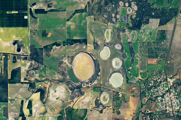
Update on September 5, 2023: This puzzler image shows Lake Dalaroo and clusters of “fairy circles” that seep hydrogen gas near the town of Moora in Western Australia. Congratulations to Ian Cathcart for being the first reader to correctly identify the image. Read more about the location in our Image of the Day story.
Every month on Earth Matters, we offer a puzzling satellite image. The August 2023 puzzler is shown above. Your challenge is to use the comments section to tell us where it is, what we are looking at, and why it is interesting.
How to answer. You can use a few words or several paragraphs. You might simply tell us the location, or you can dig deeper and offer details about what satellite and instrument produced the image, what spectral bands were used to create it, or what is compelling about some obscure feature. If you think something is interesting or noteworthy, tell us about it.
The prize. We cannot offer prize money or a trip on the International Space Station, but we can promise you credit and glory. Well, maybe just credit. Within a week after a puzzler image appears on this blog, we will post an annotated and captioned version as our Image of the Day. After we post the answer, we will acknowledge the first person to correctly identify the image at the bottom of this blog post. We also may recognize readers who offer the most interesting tidbits of information. Please include your preferred name or alias with your comment. If you work for or attend an institution that you would like to recognize, please mention that as well.
Recent winners. If you have won the puzzler in the past few months, or if you work in geospatial imaging, please hold your answer for at least a day to give less experienced readers a chance.
Releasing comments. Savvy readers have solved some puzzlers after a few minutes. To give more people a chance, we may wait 24 to 48 hours before posting comments. Good luck!
It looks like sink holes in Sybieria, caused by thawing permafrost.
Location looks as if it’s in Southeastern Australia (because of the greenery), most likely in the state of NSW but it might be in VIC or possibly SA.
Not much else I know about agriculture/ponds so I’ll leave it here for now.
YARRIE LAKE IN AUSTRALIA FORMED DUE TO IMPACT OF METEORITE
A lake in Australia formed due to impacts of meteorites. When did this happened? Still it’s puzzling.
I believe this image was captured in western Australia using a satellite. Western Austlaria is dry and westerly winds are blowing. Oval landforms may be salt lakes with sand dunes on the west side (dark green colored).
I always look forward to seeing your images. Thanks!!
Moora, Western Australia, Lake Dalaroo and the clay pans. This early spring image is green for this time of year and home to significant wildflower blooms.
This is the town of Moora in Western Australia with Lake Dalaroo at the centre of the image
New Zealand, South Island, hydrothermal lakes
Sinkhole cluster next to City in Florida, taken in the Visible Spectrum.
Moora, Western Australia.
With Moora Citrus in the top left corner!
Salt pans
Sinkholes filled with water, lakes in limestone topography in Florida.
Melting of permafrost in Siberia?
Lake Dalaroo in Western Australia situated nearby to the town Moora.
Latitude -30.62199° or 30° 37′ 19″ south, Longitude 115.95418° or 115° 57′ 15″ east.
The estimate terrain elevation above seal level is 149 metres.
Francesco from Italy
Lake Dalaroo in Western Australia situated nearby to the town Moora.
Latitude -30.62199° or 30° 37′ 19″ south, Longitude 115.95418° or 115° 57′ 15″ east.
The estimate terrain elevation is about 150 metres (653 feet) above seal level.