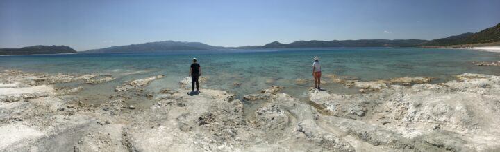
On February 18, 2021, the Perseverance rover is scheduled to make a historic landing in Jezero Crater on Mars. The rover will survey the area and collect rock samples to send back to Earth. Even though no human has set foot inside the crater, researchers have some ideas of what to expect thanks to a similar landscape on Earth: Lake Salda.
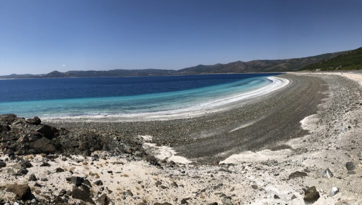
You might not think a lake in southwestern Turkey has much in common with an impact crater on Mars, but the two basins contain similar mineralogy and geology. In fact, Lake Salda is the only known lake on Earth that contains carbonate minerals and depositional features (deltas) similar to those found at Jezero Crater, which is thought to have once contained a lake.

Briony Horgan, a planetary scientist at Purdue University and member of the Perseverance science team, and colleagues from the Istanbul Technical University traveled to Lake Salda in the summer of 2019 to study the shorelines and surrounding area. They aimed to get a better understanding of the microbial and geological processes at Lake Salda to help guide the search for life at Jezero.
Below are photographs taken by Horgan’s graduate student Bradley Garczynski at Lake Salda showing some features that the Perseverance team hopes to find at Jezero Crater.
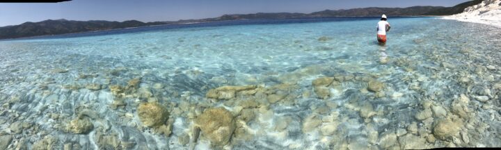
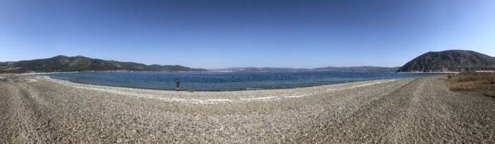
The shoreline and surrounding bedrock around Lake Salda contain sediments of different origins. The photo below shows beach sediments along the northeastern edge of the lake.
The darker-toned sediments were eroded from the steep exposures of the surrounding bedrock. The light-toned sediments are made up of the carbonate mineral hydromagnesite. You can also see the shallow carbonate bench (one to two meters thick) that extends about 40 meters offshore before steeply dropping off to deeper water.
Using data from NASA’s Mars Reconnaissance Orbiter, researchers detected a mixture of watershed minerals and possibly carbonate along the western margins of Jezero Crater, which scientists believe to be the shoreline of an ancient lake. Horgan and colleagues are interested to learn if these deposits are similar to those at Lake Salda.
Researchers are especially interested in the lighter sediments around Lake Salda because they could help inform the search for biosignatures — evidence of past or present life — at Jezero Crater.
The hydromagnesite sediments around Lake Salda are thought to have eroded from large mounds called “microbialites”—rocks formed with the help of microbes. Hydromagnesite sediments may be similar to carbonate minerals detected at Jezero. The photo below shows an exposed island made up of large mounds of old microbialites at Lake Salda.
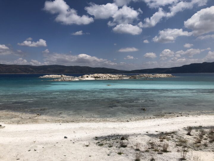
These structures themselves are good indicators that microbes were once active, so researchers will be looking for signs of these in rocks at the Martian crater.
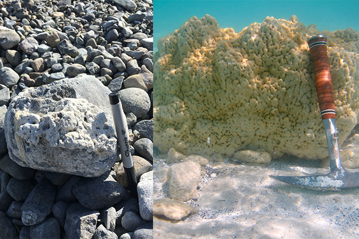
The images below show an older microbialite at Lake Salda that grew on the surface of a rock along the shore of an alluvial fan delta (left) and an underwater image of a modern microbialite at around one meter deep (right). The yellow-green film on the surface is made up of microbial communities that aid in the precipitation of hydromagnesite.
The delta near Jezero Crater adds to the evidence that it once contained a lake. Similarly, Lake Salda contains alluvial fans full of rock deposits eroded and washed down from the surrounding bedrock (shown below). By studying how stones settled in Lake Salda’s alluvial fans, the team can learn more about the depositional processes at Jezero.
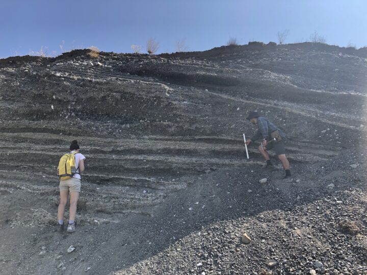
The image below shows an outcrop of sediment deposited by an ancient stream when the water levels were much higher around Lake Salda. The different layers represent different periods of deposition and include various grain types and sizes. The Perseverance rover will look for similar deposits at Jezero to learn more about its geologic history.
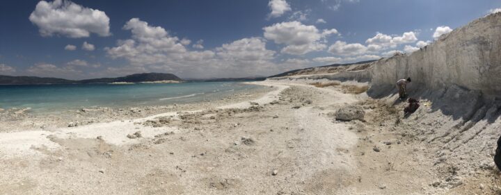
The image below shows a terrace deposit on the southwest peninsula of the lake.
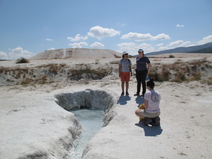
Groundwater springs at Lake Salda (shown below) play an important role in altering the lake chemistry and influencing the environment for microbes.
The image below shows a mud-dominated shoreline on the northeastern edge of Lake Salda. The mud is likely due to a nearby groundwater seep. The darker features just offshore are modern microbialites actively accreting in this muddy embayment.
It is unknown what role groundwater may have played at Jezero. Studying analog environments like Lake Salda helps provide researchers better context while looking for evidence of past groundwater at Jezero and further advance the search for potential biosignatures.
With these observations from Lake Salda, Horgan and her colleagues have been able to better focus their research questions. If microbes existed in the ancient Jezero lake, where did they live and build microbial structures? Where are the best places to search for past evidence of them: near groundwater springs? Near the delta? Or farther away in quiescent shorelines or muddy embayment?
The quest to answer these questions begins this month. Watch the Perseverance landing on February 18, 2021, at 11:15 a.m. PST / 2:15 p.m. EST live here.
Read more about the similarities between Lake Salda and Jezero Crater here.
Special thanks to Bradley Garczynski for helping provide the image descriptions.
Every month on Earth Matters, we offer a puzzling satellite image. The February 2021 puzzler is above. Your challenge is to use the comments section to tell us what we are looking at, where it is, and why it is interesting.
How to answer. You can use a few words or several paragraphs. You might simply tell us the location, or you can dig deeper and explain what satellite and instrument produced the image, what spectral bands were used to create it, or what is compelling about some obscure feature. If you think something is interesting or noteworthy, tell us about it.
The prize. We cannot offer prize money or a trip to Mars, but we can promise you credit and glory. Well, maybe just credit. A few days after a puzzler image appears on this blog, we will post an annotated and captioned version as our Image of the Day. After we post the answer, we will acknowledge the first person to correctly identify the image at the bottom of this blog post. We also may recognize readers who offer the most interesting tidbits of information about the geological, meteorological, or human processes that have shaped the landscape. Please include your preferred name or alias with your comment. If you work for or attend an institution that you would like to recognize, please mention that as well.
Recent winners. If you’ve won the puzzler in the past few months, or if you work in geospatial imaging, please hold your answer for at least a day to give less experienced readers a chance.
Releasing Comments. Savvy readers have solved some puzzlers after a few minutes. To give more people a chance, we may wait 24 to 48 hours before posting comments. Good luck!
Every year, a group of scientists affiliated with the Global Carbon Project give Earth something like an annual checkup. Among the key questions they address: how much carbon is stored in the atmosphere, the ocean, and the land? And how much of that carbon has moved from one reservoir to another through fossil fuel burning, deforestation, reforestation, and uptake by the ocean each year?
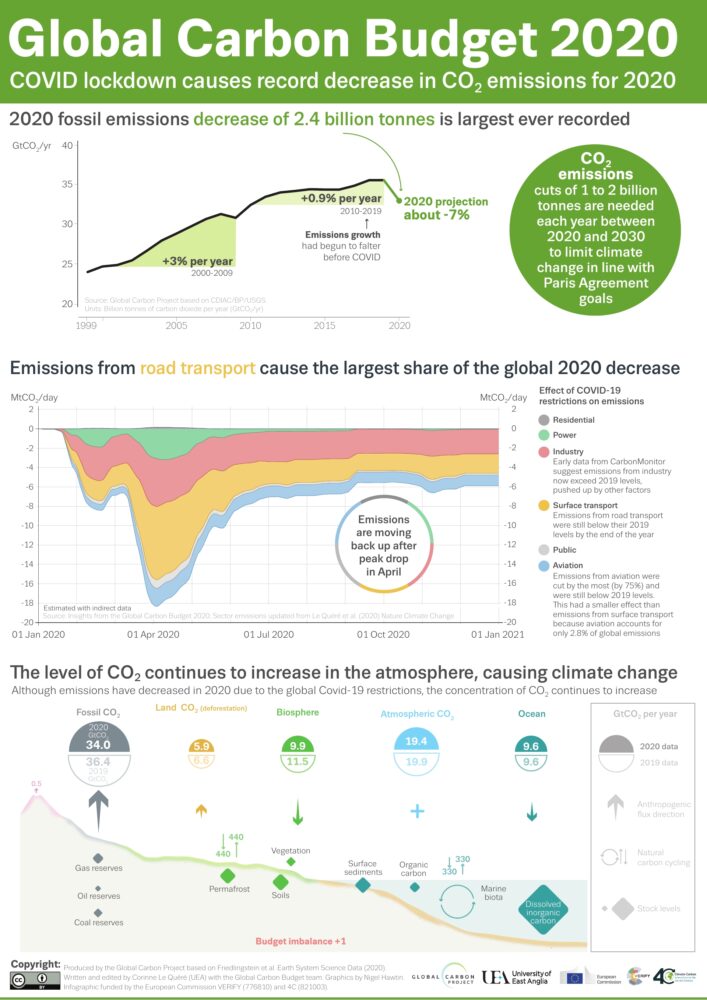
All of the latest findings—including the data for 2020, a year like few others—are available here, including links to dozens of interesting charts and a peer-reviewed science paper. Ben Poulter, a NASA scientist and member of the Global Carbon Project team, summarized the findings this way: “The economic effects of COVID-19 caused fossil fuel emissions to decrease by 7 percent in 2020, but we continued to see atmospheric CO2 concentrations increase, by 2.5 ppm, or about 5.3 PgC. This means that the remaining carbon budget to avoid 1.5 or 2 degrees warming continues to shrink, and that we need to continue to monitor the land, ocean, and atmosphere to understand where fossil fuel CO2 ends up.”
Below are 10 key findings from the most recent report. (Note: the Global Carbon Project team synthesizes a broad range of data, some of which requires time-consuming processing, quality-control, and analysis. While they do report some 2020 numbers, the most recent full year of data available for others is 2019.)


The Global Carbon Budget is produced by more than 80 researchers working from universities and research institutions in 15 countries. Observations from several NASA satellites, sensors, aircraft, and models were among the sources of information used to formulate the 2020 budget. Sources of information supported by NASA included: the MODIS sensors on Aqua and Terra satellites, the Global Fire Emissions Database (GFED), the LPJ land surface carbon exchange model, Landsat, the LUHv2 land-cover change model, the CASA land surface carbon exchange model, ODIAC fossil fuel emissions data, the MERRA-2 reanalysis, the Cooperative Global Atmospheric Data Integration Project, and OCO-2.
For more than 20 years, astronauts have been shooting photographs of Earth from the International Space Station. Before that, they looked down from Mercury, Gemini, Apollo, Skylab, the Space Shuttles, and MIR. They have brought us unique views of our home planet in all of its wonder, beauty, and ferocity. They have also made some interesting and timely science observations along the way.
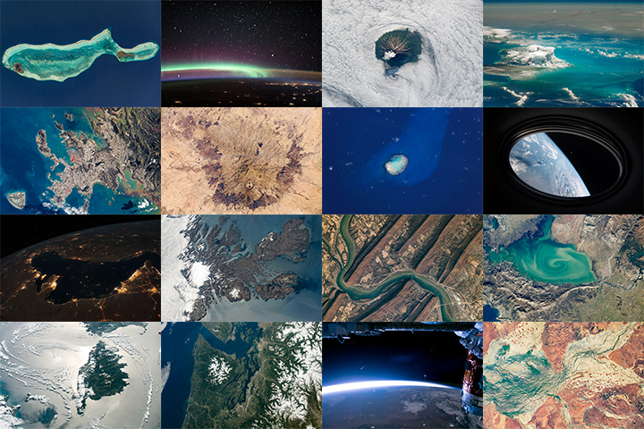
More than 1,000 of those photos have been published here on NASA Earth Observatory. We would like you to help us choose the best in our archives. In early March, we will launch Tournament Earth: Astronaut Photography, and we want you to be part of the selection committee.
From now through February 19, 2021, search our archives and point out the best photos shot by the astronauts. Post the URLs of your favorite photos in the comments section below.
Please choose images from these collections:
EO Astronaut Photography Collection
Visible Earth: Astronaut Photography
Please note that there are 30+ pages of images to scroll through — an internet rabbit hole of incredible beauty.
In March 2021, we will include some of your selections in Tournament Earth, a head-to-head contest to vote for the best of the best from our archives. Each week, readers will pick from pairs of images as we narrow down the field from 32 nominees to one champion. The Tournament Earth champion will be announced in early April.
So get browsing and get choosing. Then post your favorite URLs in the comments section by February 19.
If you want to learn more about how and why astronauts shoot photos of our planet — and the special training involved — check out our video series “Picturing Earth.”
Astronaut Photography in Focus
Trees connect us scientifically, environmentally, and culturally. We all know that trees are vital to our planet’s health. As trees grow, they absorb carbon from the atmosphere, playing a vital role in Earth’s global carbon cycle and helping to regulate Earth’s carbon budget.
But before you read any further, look around…especially if you are outside. Most of you can look in any direction and see a tree. You might wonder about a few things like: “What type of tree is that?” or “Why is that tree so tall or short?” or “How old is that tree?” or even “Was that tree planted by someone, or did the wind blow a seed to where the tree is now standing?”
Or what if you don’t see any trees? What does that signify about the environment? Did nature make it that way, or did humans? All of these are great questions that can help us understand and connect with the environment.
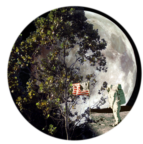
A few trees on Earth also connect us to the Moon. Have you ever heard of “Moon Trees?”
“Moon Trees” never actually grew on the Moon, but their seeds were taken into lunar orbit 50 years ago this week. The NASA Moon Trees history website explains:
Apollo 14 launched in the late afternoon of January 31, 1971, on what was to be our third trip to the lunar surface. Five days later, Alan Shepard and Edgar Mitchell walked on the Moon while Stuart Roosa, a former U.S. Forest Service smoke jumper, orbited above in the command module. Packed in small containers in Roosa’s personal kit were hundreds of tree seeds, part of a joint NASA/USFS project. Upon return to Earth, the seeds were germinated by the Forest Service. Known as the “Moon Trees,” the resulting seedlings were planted throughout the United States (often as part of the nation’s bicentennial in 1976) and the world. They stand as a tribute to astronaut Roosa and the Apollo program.
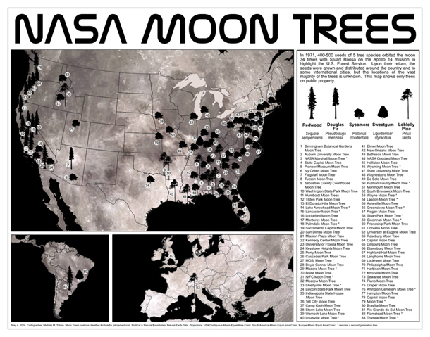
Among the Moon Trees that were eventually planted around the United States and the world were sycamores, Loblolly pines, redwoods, sweetgums, and Douglas firs. Though it is unlikely the Moon Tree seeds were changed much by their brief lunar orbit, it is still a wonder that they made it into space and back, and that many of the trees are growing and thriving today.
So, where can you find them? The NASA Moon Trees site has a list, and there is also an article and photographs from our friends at National Geographic. UC Davis data scientist Michele M. Tobias created the map below. You can also learn more about the trees from our colleagues at Marshall Space Flight Center.
Perhaps you might see some Moon Trees in person in the next year or two. If you do, consider making tree height observations using the tree tools on the NASA GLOBE Observer app. When completing your observation, let us know in the app.
Have you ever visited and seen a Moon Tree? Tell us about it below.
