The Grand Canyon in northern Arizona has a long history. Between 5-6 million years ago, the Colorado River started carving through a high, flat plateau. About 12,000 years ago, people in the vicinity of the canyon left behind the area’s oldest known human artifacts. One-hundred years ago, a signature by President Woodrow Wilson established the Grand Canyon as a National Park.
NASA Earth Observatory has existed for just one-fifth the time of Grand Canyon National Park. But over those 20 years, satellites and astronauts have captured some magnificent views of the park from above. Here are some of our favorites.
“If you want to see the whole canyon at once, an airplane won’t do. You have to be in orbit. I would highly recommend the International Space Station, if you have the chance.”
Marker Marshall, U.S. National Park Service ranger at the Grand Canyon
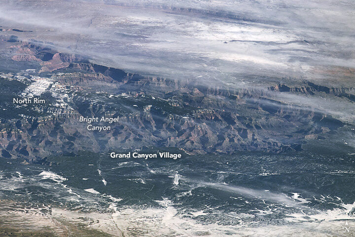
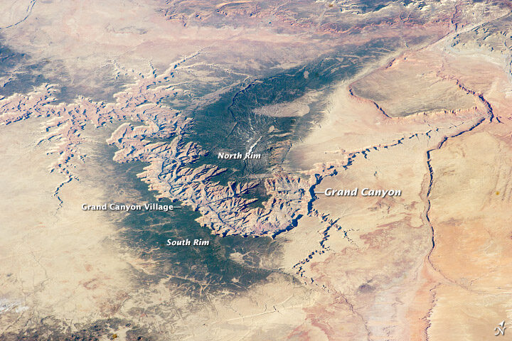
The top image, shot by an astronaut from the International Space Station (ISS), shows the canyon in winter 2009, when snow blanketed part of the plateau. The second image, also shot from the ISS, shows the canyon in spring 2014.
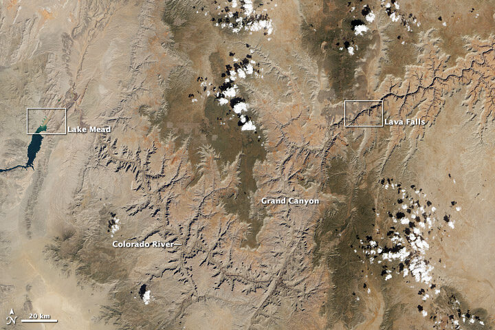
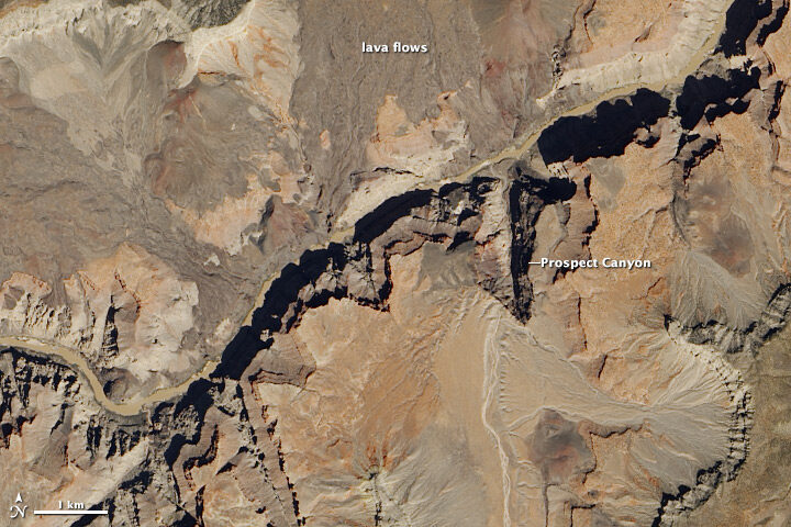
Satellites usually offer nadir (straight-down) views of the canyon, such as these natural color images acquired with the Landsat 8 satellite in April 2013. The wide view shows the canyon in context with the surrounding plateau, while the detailed image shows an area around the rapids known as Lava Falls (in reference to old lava flows in the area).
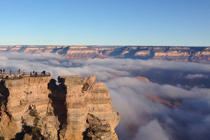
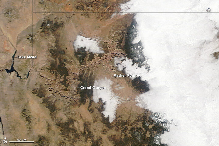
In its 100 years as a National Park, the canyon still turns up surprises to visitors and Park Service rangers. These images show a rare weather event in December 2013 that filled the canyon with an ocean of clouds.
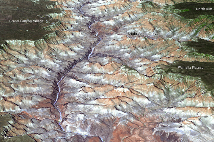
Three-dimensional views are also possible from space. An improved version of a digital topographic map of Earth released in October 2011 made it possible to produce this 3D view of the eastern part of the Grand Canyon.
You can view more Earth Observatory images of the Grand Canyon here. And if you find yourself in Arizona, here is list of centennial events hosted by the National Park Service throughout the year.
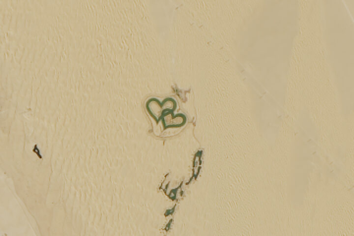
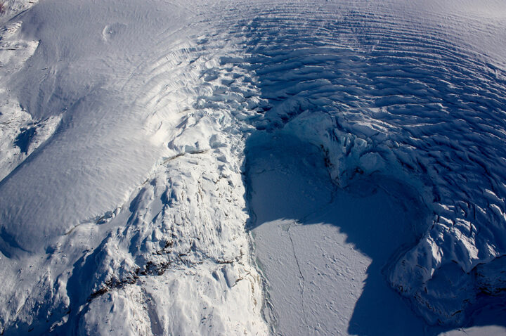
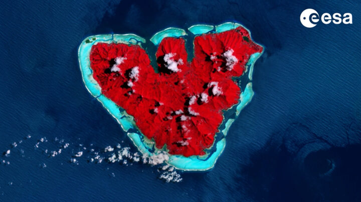
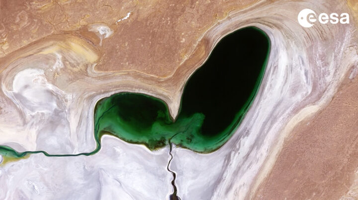
When you look at Earth from above as often as we do, you become intimately familiar with the shapes and patterns that can emerge across the planet. Some are made by people and others by nature. Some are ephemeral and others more permanent.
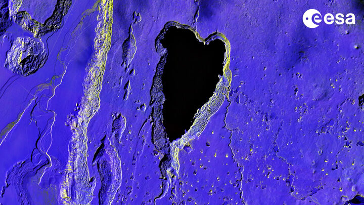
Today we took a light-hearted approach to the Image of the Day, explaining the science behind one such shape—what appears to be a Valentine in the Sky. The image prompted us to look and see where other heart-shaped features have turned up.
Heart-Shaped Uummannaq
Love Lake
Heart-shaped Calving Front
Island Love
Shrinking Heart
Loving Big
On February 12, 1809, Charles Robert Darwin was born in England in the town of Shrewsbury. The famed naturalist, geologist, and biologist is best known for his 19th century expedition to the Galápagos Islands, which inspired revolutionary insights about evolution and natural selection. Lesser known is that the expedition to the Galápagos was just one part of a much longer journey. The Second Voyage of the HMS Beagle brought Darwin and his fellow travelers to South America, Australia, Africa, and several islands in between. Here are a few interesting places where the HMS Beagle stopped that we have covered in earlier stories.
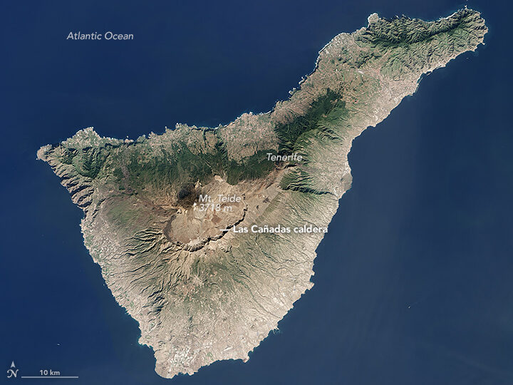
The crew of the Beagle was denied landing on Tenerife because of fears they might be carrying cholera. The Operational Land Imager (OLI) on Landsat 8 acquired this image of the island on January 25, 2016.
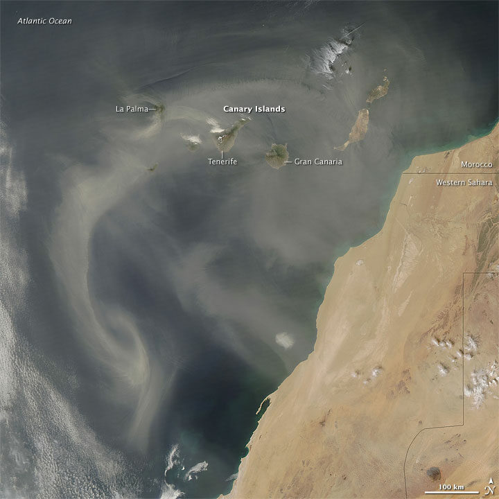
Darwin was struck by the intensity of the dust in this area. “The atmosphere is generally very hazy, chiefly due to an impalpable dust, which is constantly falling, even on vessels far out at sea,” he wrote. “It is produced, as I believe, from the wear and tear of volcanic rocks, and must come from the coast of Africa.”
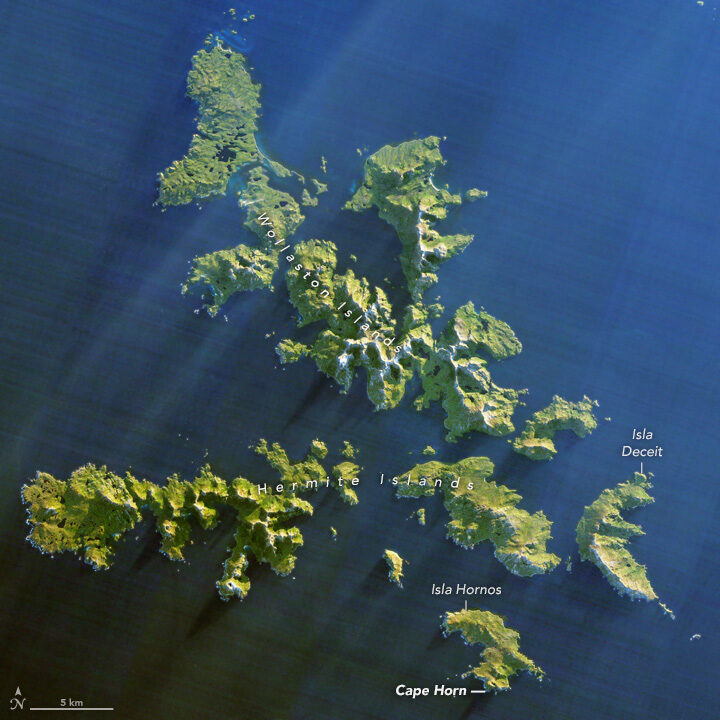
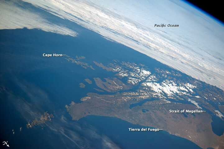
Southwest of Cape Horn at the southern tip of South America, the ocean floor rises sharply. Along with the potent westerly winds that swirl around the Furious Fifties, this pushes up massive waves with frightening regularity. Add in frigid water temperatures, rocky coastal shoals, and stray icebergs—which drift north from Antarctica across the Drake Passage—and it is easy to see why the area is known as a graveyard for ships. In his journal, Darwin described the harrowing journey as the explorers tried to round the Horn just before Christmas.
“Great black clouds were rolling across the heavens, and squalls of rain, with hail, swept by us with such extreme violence, that the Captain determined to run into Wigwam Cove. This is a snug little harbor, not far from Cape Horn; and here, at Christmas-eve, we anchored in smooth water. The only thing which reminded us of the gale outside, was every now and then a puff from the mountains, which made the ship surge at her anchors.”
Charles Darwin
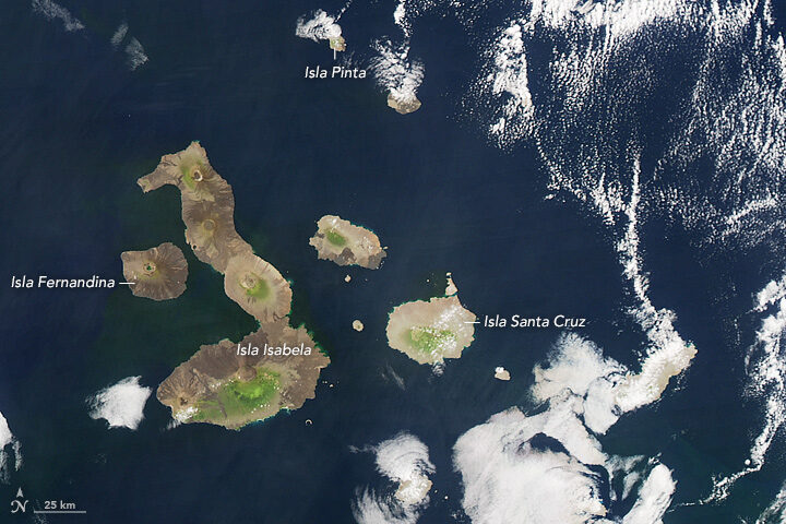
The Galapagos archipelago includes more than 125 islands, islets, and rocks populated by a diversity of wildlife. Charles Darwin’s book, The Voyage of the Beagle, cast a spotlight on the Galapagos, which he called “a little world within itself, or rather a satellite attached to America, whence it has derived a few stray colonists.” It was this little world that would revolutionize scientific understanding of biology and lead to Darwin’s On the Origin of Species, which would come to be known as the foundation of evolution.
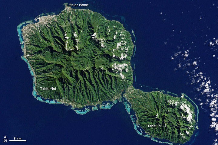
On this stopover, Darwin had a chance to explore coral reef.
“We paddled for some time about the reef admiring the pretty branching Corals,” he wrote. “It is my opinion, that besides the avowed ignorance concerning the tiny architects of each individual species, little is yet known, in spite of the much which has been written, of the structure and origin of the Coral Islands and reefs.”
The Enhanced Thematic Mapper Plus on the Landsat 7 satellite captured this natural-color image of Tahiti on July 11, 2001. This island is part of a volcanic chain formed by the northwestward movement of the Pacific Plate over a fixed hotspot.
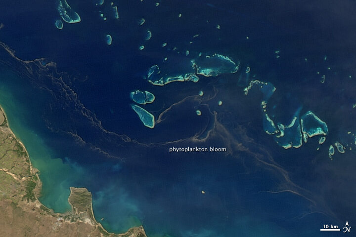
All the sea travel offered plenty of time to observe and ponder the intricacies of phytoplankton.
“My attention was called to a reddish-brown appearance in the sea. The whole surface of the water, as it appeared under a weak lens, seemed as if covered by chopped bits of hay, with their ends jagged,” he wrote. “These are minute cylindrical, in bundles or rafts of from twenty to sixty in each…Their numbers must be infinite: the ship passed through several bands of them, one of which was about ten yards wide, and, judging from the mud-like color of the water, at least two and a half miles.”
On August 9, 2011, the Moderate Resolution Imaging Spectroradiometer (MODIS) on the Aqua satellite captured this image of a similar band of brown between the Great Barrier Reef and the Queensland shore. Though it’s impossible to identify the species from satellite imagery, such red-brown streamers are usually trichodesmium. Sailors have long called these brown streamers “sea sawdust.”
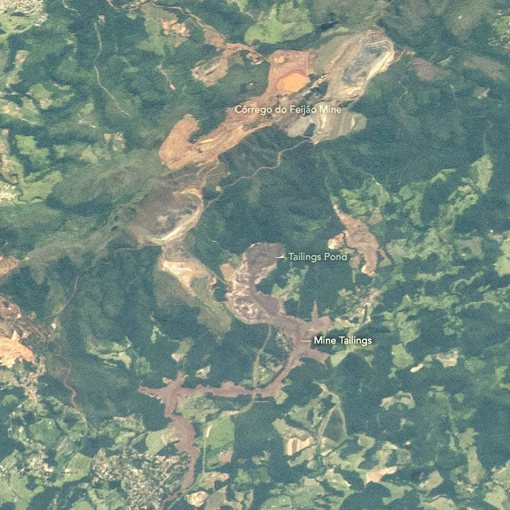
A few days after we published a Landsat 8 image of a deadly dam collapse and flood in Brazil, astronauts photographed the scene from the International Space Station on February 2, 2019.
The tailings pond label points to the source of the mine waste. When an earthen dam on the southwestern edge of that pond collapsed on January 25, it sent a torrent of sludge pouring down a valley toward the Paraopeba River. Over a distance of roughly 8 kilometers (5 miles), the mine sludge overran the mine’s headquarters, a hotel, and a residential area. Videos published by news agencies and AGU’s Landslide Blog offer a remarkable view of the dam collapsing and sludge rushing forward at roughly 120 kilometers (75 miles) per hour.
NASA’s Earth Science Disasters Program has developed an interactive version of the astronaut photograph that allows you to explore the area before and after the disaster. More astronaut photos of the event are available here.
NASA was mostly shut down for January 2019, but Earth wasn’t. In case you missed it, here are some of the big stories we didn’t cover during the impasse.
Scientists Find Evidence of An Ancient Earth Rock on the Moon
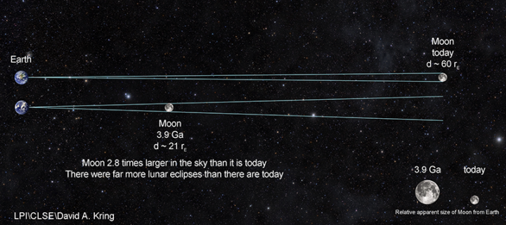
Four billion years ago, the Moon was about three times closer to Earth than it is now. So if a large asteroid or comet slammed into Earth and jettisoned material into space, it was more likely that rock fragments might end up landing on the Moon. That’s how an international team of scientists working with the Center for Lunar Science and Exploration (CLSE) think that a small fragment composed of quartz, feldspar, and zircon—a combination of minerals commonly found on Earth—ended up embedded within a larger Moon rock collected by Apollo astronauts. The team recently revealed evidence from the ancient rock fragment, suggesting that it is one of the oldest Earth rocks ever found.
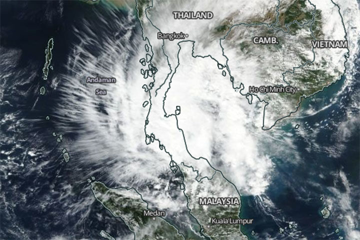
A Rare Typhoon Hits Thailand
It is rare for powerful tropical storms to strike Thailand. Before January 2019, the last time it happened was 1962. So meteorologists took notice when Tropical Storm Pabuk slammed into southern Thailand on January 4, 2019, packing sustained winds of 95 kilometers per hour (60 mph) and delivering torrential rains to some of Thailand’s most popular tourist destinations. The Moderate Resolution Imaging Spectroradiometer (MODIS) on NASA’s Aqua satellite captured this image of the storm on January 4, 2019.
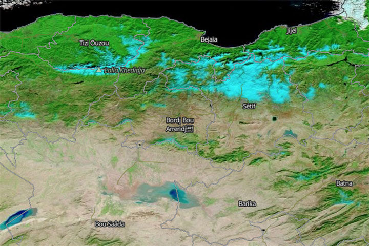
Snow Falls in Algeria (Yes, the Sahara)
In another unusual weather event, fresh snow created surreal scenery in Algeria when it coated Saharan desert dunes in mid-January. This is just the third time snow has fallen in Ain Sefra, the gateway to the Sahara Desert, in the past 37 years. (The last time was 2018.) The Moderate Resolution Imaging Spectroradiometer (MODIS) on NASA’s Terra satellite captured an image of the snow on January 14, 2019. It is composed with false color, using a combination of infraed and visible light (MODIS bands 7-2-1). Snow appears blue with this band combination.
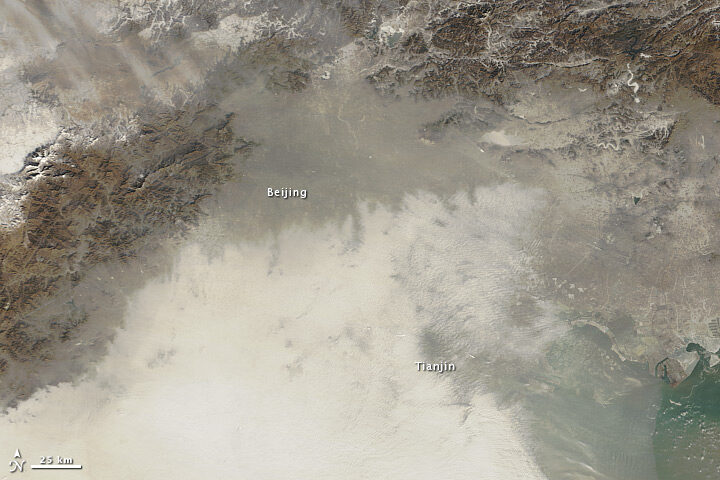
China’s War on Particulates May Be Making Ozone Pollution Worse
For the past few years, China has advanced an ambitious plan to reduce emissions of fine particulate (PM2.5), a harmful type of air pollution. Authorities have restricted the number of vehicles on the roads, capped how much coal industries can burn, and shuttered many polluting factories and power plants. The result has been impressive: over five years, concentrations of PM2.5 in eastern China have fallen nearly 40 percent. But, there is another wrinkle. Particulates also sponge up substances that make it harder for ground-level ozone to form. So even as concentrations of PM2.5 decline, ozone concentrations are rising, new research shows.
Can Satellites Sense Poverty?
Increasingly, yes, at least in rural areas. By analyzing observations of villages in Kenya, one team of researchers recently showed that land use and land cover data from satellites contains some useful clues for identifying the poorest households in rural areas. Key indicators included: the size of buildings within a homestead, the amount of bare agricultural land adjacent to a homestead, and the length of the growing season. The researchers think this type of information could make it easier to monitor the progress of efforts designed to reduce poverty in rural areas, such as the U.N. Sustainable Development Goals.
A meteor exploded over western Cuba on February 1, 2019, and it delivered an impressive light show. The event was captured by numerous ground-based cameras. It was also spotted from space.

Researchers from the Cooperative Institute for Meteorological Satellite Studies wrote a blog post showing a series of images and data from the event, including the animation above. It was composed from false-color images gathered by NOAA’s GOES-16 satellite. (NASA builds GOES satellites for NOAA.) The dark blue pixels moving toward the northeast appear to be the signature of a debris cloud drifting in the atmosphere after the meteor exploded. A close look at visible imagery from GOES-16 reveals a shadow apparently cast by the debris cloud.
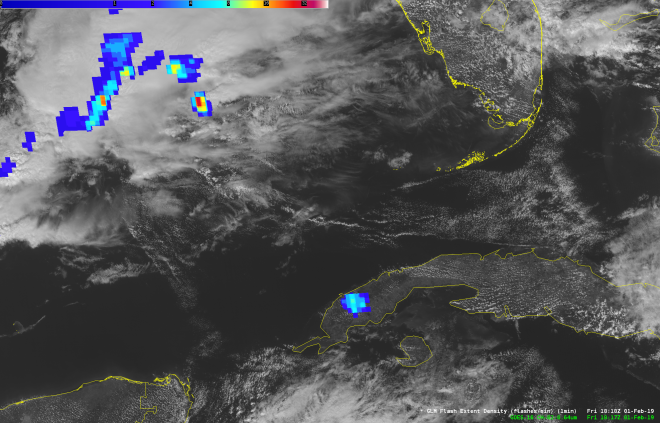
Meanwhile, scientists at NASA’s Short-term Prediction Research and Transition Center (SPoRT) reported signs of the meteor flash in an image acquired by the Geostationary Lightning Mapper (GLM). The meteor flash appears in this image as blue pixels over Cuba. (The blue in the top-left corner is lightning activity over the ocean.)
The meteor was notably smaller than the rock that exploded in February 2013 over Chelyabinsk, Russia. That event injected hundreds of tons of dust into the stratosphere and set the stage for scientists to directly study the plume’s long-term evolution in Earth’s atmosphere.
