
Every month on Earth Matters, we offer a puzzling satellite image. The June 2018 puzzler is above. Your challenge is to use the comments section to tell us what we are looking at and why this place is interesting.
How to answer. You can use a few words or several paragraphs. You might simply tell us the location. Or you can dig deeper and explain what satellite and instrument produced the image, what spectral bands were used to create it, or what is compelling about some obscure feature in the image. If you think something is interesting or noteworthy, tell us about it.
The prize. We can’t offer prize money or a trip to Mars, but we can promise you credit and glory. Well, maybe just credit. Roughly one week after a puzzler image appears on this blog, we will post an annotated and captioned version as our Image of the Day. After we post the answer, we will acknowledge the first person to correctly identify the image at the bottom of this blog post. We also may recognize readers who offer the most interesting tidbits of information about the geological, meteorological, or human processes that have shaped the landscape. Please include your preferred name or alias with your comment. If you work for or attend an institution that you would like to recognize, please mention that as well.
Recent winners. If you’ve won the puzzler in the past few months or if you work in geospatial imaging, please hold your answer for at least a day to give less experienced readers a chance to play.
Releasing Comments. Savvy readers have solved some puzzlers after a few minutes. To give more people a chance to play, we may wait between 24 to 48 hours before posting comments.
Good luck!
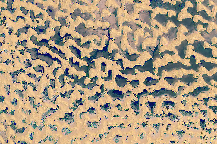
Answer: The Rub’ al-Khali is the world’s largest contiguous sand desert, located on the Arabian Peninsula. It is typically one of the driest places on Earth. The image above shows the desert after rainwater associated with Tropical Cyclone Mekuno pooled between the dunes. Congratulations to John Morales for being the first to correctly name the desert, and to AIYED for also naming the storm system. Read more about the image in our June 16, 2018, Image of the Day.
Tags: puzzler
Looks like clouds over Pacific Ocean and Mexico near Mexico City.
Southeast Saudi Arabia
Latitude: 19.7183; Longitude: 53.4005
Just north of Omani border
East-to-west: ~40 km; N-to-S: ~26 km
On Twitter: @DaveAtCOGS
Lençóis Maranhenses National Park, located in the Brazilian state of Maranhão Brazil’s Sand Dune Lagoons.
wave interaction with old or shusa sea ice?
Hi!
The place is Parque Nacional dos Lençois Maranhenses, Brazil.
Thanks
June 2018
I would say Chad Republic in Africa. At least double direction sand deposits, over the water ground northeast region of Lake Tchad. Bol and Tipsi area. We can see some filters in the picture changing the color of the sand and the ground lake water which seem the shadows of the dunes. Maybe dry season, regularly the area is completed flooded.
That photo looks like the Parque Nacional dos Lençóis Maranhenses in Brazil. You can make out the pools on what looks to be the south sides of the sand dunes.
Hi,
The image shows the Parque Nacional dos Lençois Maranhenses, in Brazil.
Thank you
Mud Flats Alaska.
It’s macaroni and cheese.
Sand dunes with water.
Could it be the Rub’ al Khali desert in the Empty Quarter in Saudi Arabia where the water table is near the surface creating a region where the dunes are interspersed with swampy lands and water during very wet years?
sand dunes from inner mongolia the gobi desert.
Sand dunes with vegetation in the vallies after rain?
Lake Chad where the lake is drying out and turning into desert. This is a Ramsar listed site and the desertification of the lake threatens hundreds of species, as well as local communities
Dry lake bed. Appears to be a few less than 10 cliuds formed in places located near the water features.
This looks like the Sahara after the big rain storms of October 2017. Sand dunes surrounded by standing water from the heavy rain.
A Greenland iceberg. Ice & pockets of meltwater.
I think it’s the edge of Lake Chad – it’s hard to pinpoint the exact location, as the dunes are changing constantly. The dunes themselves seem to be slowly drying as the lake desiccates.
– Robert Emberson
I believe this is Lençóis Maranhenses National Park in Brazil. The lighter color are sand dunes and the darker color are natural lagoons.
Sand dunes and ponds – northern Brasil – Lençóis Maranhenses National Park.
Rivers push sand from the interior of the continent, depositing sediment along Brazil’s northern coast. Winds from the equatorial Atlantic push the sand back inland, as far as 30 miles creating sand dunes.
The area receives 47 inches of rain a year – not quite a desert!
From January to June, rainwater from torrential storms pools between the dunes creating lagoons. Despite the size – some are over 300 feet long and ten feet deep – they exist for only a few months a year – equatorial sun dries them up quickly.
-2.494159°
-43.116389°
Satellite photo of a Kavir desert (Iran) or (Tibet). Showing seasonal rise of the
Water table and it’s exposed concentration by evaporation and resulting
Precipitation of salts
Rub al Khali sand dunes, Saudi Arabia
The desert of the Empty Quarter in Saudi Arabia after the rain of Cyclone Mukono, reaching a rate of 300 mm and there are valleys flowing from the mountains of Oman to the north and formed a group of lakes
SAUDI ARABIA EMPTY QUARTER
Lake Tchad. Water and Dunes.
Tschadsee in Afrika. Seewasser und Dünen
A salt mine. The green is water. The bright yellow is sand. Very pale yellow is sand.
Possibly a rotated image (top is not north) of the dune margin around lake Chad.
Considering how easy it is to simply drag the photo over to google images to get images that are similar and go from there if not actually get a perfect match, there is little point to this puzzle anymore.
So who was correct?
This website is really a walk-through for all of the info you wanted about this and didn?t know who to ask. Glimpse here, and you?ll definitely discover it.