
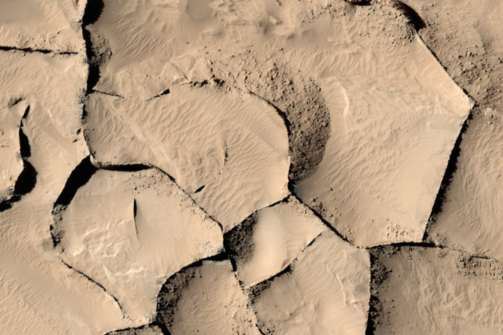
Every month on Earth Matters, we offer a puzzling satellite image. The May 2017 puzzler is above. Your challenge is to use the comments section to tell us what we are looking at, when the image was acquired, and why the scene is interesting.
How to answer. Your answer can be a few words or several paragraphs. (Try to keep it shorter than 200 words). You might simply tell us what part of the world an image shows. Or you can dig deeper and explain what satellite and instrument produced the image, what spectral bands were used to create it, or what is compelling about some obscure speck in the far corner of an image. If you think something is interesting or noteworthy, tell us about it.
The prize. We can’t offer prize money or a trip to Mars, but we can promise you credit and glory. Well, maybe just credit. Roughly one week after a puzzler image appears on this blog, we will post an annotated and captioned version as our Image of the Day. After we post the answer, we will acknowledge the person who was first to correctly ID the image at the bottom of this blog post. We may also recognize certain readers who offer the most interesting tidbits of information about the geological, meteorological, or human processes that have played a role in molding the landscape. Please include your preferred name or alias with your comment. If you work for or attend an institution that you want us to recognize, please mention that as well.
Recent winners. If you’ve won the puzzler in the last few months or work in geospatial imaging, please sit on your hands for at least a day to give others a chance to play.
Releasing Comments. Savvy readers have solved some of our puzzlers after only a few minutes or hours. To give more people a chance to play, we may wait between 24-48 hours before posting the answers we receive in the comment thread.
Good luck!
Editor’s Note: Congratulations to Maxim Nofal for being the first reader to solve the puzzler on the Earth Observatory site, and to Victor Tarazzi for answering first on Facebook. See a labeled version of the May puzzler here.
Good one, we’re looking at petrified dunes. Don’t know when the image was taken. The landscape seems to be fractured along distinct ‘faults.’ Also, some pressure solution (in a stylolite way) or karst formation is visible or seems to have taken place (crescent moon shape). Some ‘SW-NE’ lineation may indicate a dominant wind direction. It even reminds me of New Horizons Pluto images, so it might even be ice formations
The image seems like sand stone cracked rock or sand dunes.
I think this is part of desert where there has been a recent earthquak that caused such sharp trenches between the dunes.
It might even be related to areas where tactonic plates movement is prominant…
A wild guess, but i just think so.
But i found out these are polygon ridges on mars!!! Made by lava flowing into fractures in the ground, then solidifies and become more resistant to wear than surrounding matter
Sand dune formations. The feature shows some ridges which maybe from water erosion but it is interesting how the ridges move in almost angular directions which isn’t typically how water flows unless there is some fracture in the rock from seismic activity. You can see a consistent pattern of entrails in the sand all aligned in the same direction, southwest to northeast direction. This image was taken in the morning, the shadow is facing the west meaning the sun is rising in the east. What makes the image interesting the erosion pits buffering the ridge lines. This could be some erosion in the celiche rock which is natural cement which is eroded by water flow.
Türkish:
Su kaplı bir alanın sularının çekilmesi ile kuruyan toprak ve daha sonra bu maddelerin ve ya toprağın erezyon gibi afetlerle oluşan yıkılmalar sonucu maddelerin birbiri ile karışması ile oluşan bir. Yapı olabilir ..
Engilish ; It is formed by the mixing of soil which is dried by the water of a water-covered area , and then the destruction products of these materials or disasters such as erosion of soil can be structure
Looks like slot canyons that can be found in Utah and other remote parts of the US Southwest. Maybe high summer since no shadows. Am coveting being back into a slot canyon as they are awesome.
This is a pitcure taken from the HiRISE camera on NASA’s Mars Reconnaissance Orbiter,It is said that some of the ridges are to be 16 storys tall and are poloygon in shape,and are located in many regions of the planet,,
climate change issue
drought of the soil due to the action of men
in addition action of the winds on the ground
by doing an image search you can see there actually ridges formed on mars.
Drought on Earth due to the action of men – climate changes
action of winds on the soil
The scale at which the photo is taken may not be clear, it may sound like a normal crep on an arid soil or give visible turns and streaks could be a photo taken with radar and re-elaborated frequencies of a glacial environment (a glacier).
This image is taken of a volcano
Permafrost polygons in northern Russia.
https://www.nasa.gov/feature/jpl/similar-looking-ridges-on-mars-have-diverse-origins
montonate huge rocks
Could be pack ice breaking up in the Arctic, possibly north of Alaska.
I think it’s rocks shaped like two kissing or Face to face
It looks like a dried out lake bed most likely to be near Death Valley
it seems that there has been drought in the region, (where this earth part is now).and this drought has occurred since a is since a long time ago.
Good one! This challenge had me completely stumped!
Bu fotoğraf dünyadan olsaydı belki oradaki yarıklarda su var diye bilirdim. Belki geçmişten kalan nehir yatağı olabilir.