

The maps above, featured in our January 9, 2016 Image of the Day, show soil composition across the United States (bottom) and the space available for water to reside within those soil types (top). Douglas Miller—a soil, informatics, and remote sensing expert at Penn State—compiled the dataset on which the map is based (soil characteristics for the conterminous United States, or CONUS-Soil.) By combining information about soil type with current, satellite-derived estimates of soil moisture, scientists can better predict events such as flooding, drought, and severe storms. Miller answered some of questions about soil composition, water storage, and why such things matter via email.
We have all heard about soil since we were kids, but what is it actually made of?
Soil contains many different things, but the most basic elements that soil scientists would talk about include various particle sizes (sand, silt, and clay), rock fragments, open pores, roots and live organisms, water, and air. Depending upon the exact combination of all of these things, there can be more (or less) space available for water to reside. The image below shows a soil texture triangle that’s very colorful and is a handy way of thinking about soil particle composition.
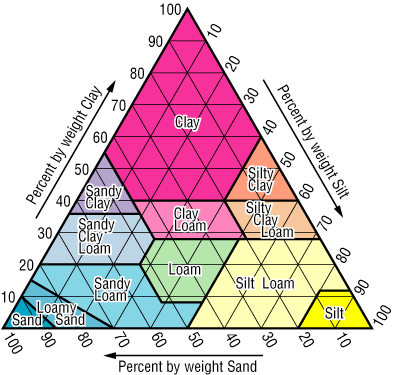
Image courtesy Douglas Miller, from the CONUS-Soil web site.
Soils that have more sand in them will not tend to hold water for a very long time. Think of what happened when you were a kid at the beach with your bucket and you tried to keep water in the castle’s moat! Soils that are heavy with clay will tend to hold water longer and not drain as quickly. Soils that have more silt in them will tend to be intermediate in drainage properties. All told, the ideal soil would have nearly equal amounts of the three major textures (somewhere in the middle of the soil triangle).
Why does soil composition matter?
Farmers, gardeners–essentially anyone interested in growing plants in soil–would be interested in knowing soil composition. Thinking back to the soil triangle mentioned above, one would ideally love to have a medium textured soil from near the middle of the soil triangle. By being aware of the soil texture that you have and the capacity of that soil to hold water (along with the water requirements of the plants that you wish to grow), you can manage your landscape. If I have too much clay in my soil, I would want to work in materials (like leaves, peat moss, etc.) to moderate the texture and open more space in the soil profile for water. Years ago, my back yard garden was mostly clay soil. For three years I chopped up all of my leaves and put them in the garden. This helped to add organic matter and nutrients, but also made the soil texture closer to middle of the triangle.
Can knowledge about soil composition and soil moisture tell you something that wouldn’t be known by looking at just one or the other?
Yes! The interesting thing about soils is that they’re closely connected to weather through soil moisture. Satellites like SMAP and SMOS, flying overhead, give us near-real time estimates of soil moisture. When combined with soil properties, we can improve our ability to predict things like flooding, drought relief, and even severe storm generation. There’s a strong connection between soil moisture at the land surface and severe storms (thunderstorms, tornados, derechos, etc.). Soil moisture near the surface is available to be easily evaporated in to the atmosphere. With the proper atmospheric conditions, rapid evaporation can lead to strong storm development. Using a combination of weather data, SMOS/SMAP data, and land surface properties (soils, vegetation, and topography), we can develop improved models that more accurately predict when and where storms and consequent flooding, damage, etc. will occur.
What have been the developments in this area of research since the dataset was compiled?
Since we compiled CONUS-Soil from the USDA National Resources Conservation Service database in the mid-1990s, USDA has now completed SSURGO–detailed soil surveys that are conducted on a county-level basis for the entire continental U.S. As compared to CONUS-Soil (1 kilometer resolution grid cells), SSURGO can be gridded at 10 meters in most places. This provides a tremendous amount of detail. I believe the entire U.S. dataset for SSURGO gridded at 10 meters is about 16GB. It’s a huge dataset.
However, a real challenge still exists in creating a standardized dataset (like CONUS-Soil) that has the same number of layers for each grid cell, anywhere in the U.S. What makes our product still unique, after all these years, are the standardized layers that a climate or hydrology model can count on being the same, from cell-to-cell. The monthly downloads that we still get for CONUS-Soil indicate that its 1-kilometer resolution is still valuable for regional climate and hydrology models. We are investigating what it will take to create a new CONUS-Soil from SSURGO (with standard layers). We believe that will require the use of a significantly sized supercomputer!
Read more in our Image of the Day, Soil Composition Across the U.S., and in our feature story, A Little Bit of Water, A Lot of Impact.
thats the ocean
hey