
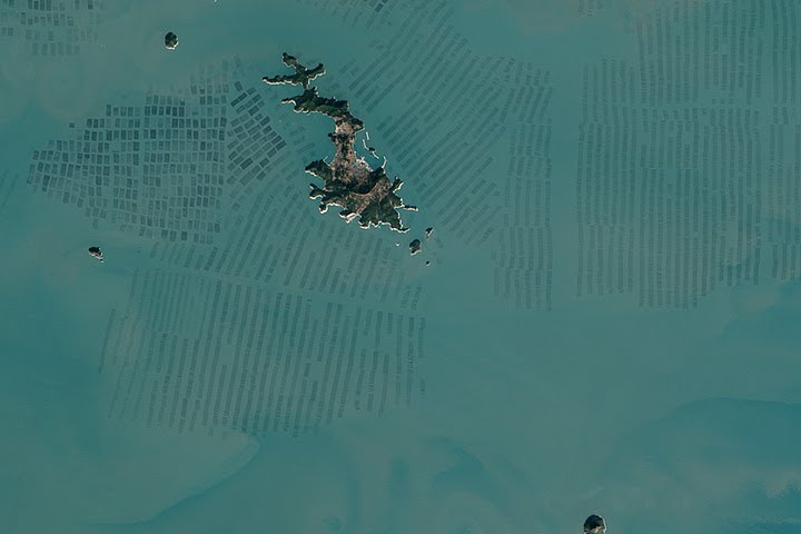
Every month on Earth Matters, we offer a puzzling satellite image. The April 2015 puzzler is above. Your challenge is to use the comments section to tell us what part of the world we are looking at, when the image was acquired, what the image shows, and why the scene is interesting.
How to answer. Your answer can be a few words or several paragraphs. (Try to keep it shorter than 200 words). You might simply tell us what part of the world an image shows. Or you can dig deeper and explain what satellite and instrument produced the image, what spectral bands were used to create it, or what is compelling about some obscure speck in the far corner of an image. If you think something is interesting or noteworthy, tell us about it.
The prize. We can’t offer prize money, but, we can promise you credit and glory (well, maybe just credit). Roughly one week after a puzzler image appears on this blog, we will post an annotated and captioned version as our Image of the Day. In the credits, we’ll acknowledge the person who was first to correctly ID the image. We’ll also recognize people who offer the most interesting tidbits of information about the geological, meteorological, or human processes that have played a role in molding the landscape. Please include your preferred name or alias with your comment. If you work for or attend an institution that you want us to recognize, please mention that as well.
Recent winners. If you’ve won the puzzler in the last few months or work in geospatial imaging, please sit on your hands for at least a day to give others a chance to play.
Releasing Comments. Savvy readers have solved some of our puzzlers after only a few minutes or hours. To give more people a chance to play, we may wait between 24-48 hours before posting the answers we receive in the comment thread.
Good luck!
This an aerial view of Sea Weed Farms in Japan. The dark bands are beds of Sea Weed which is one of the popular dietary ingredients in Japanese cuisine.
Aquaculture, perhaps oyster beds, off the coast of Australia? Taken 3 weeks ago?
Sisan-Ri, island of coast South Korea showing aquaculture beds, perhaps oysters?
Sisan-ri, Goheung-gun, Jeollanam-do, South Korea
It looks to me like a fish farming operation, with the fish pens laid out in neat rows, with enough space between them to service the individual pens. The island serves as a processing base and where the operators live? The sea seems quite shallow, my guess is somewhere along the east Asian coast, Vietnam maybe.
The Iceland volcano eyjafjallajo
It’a a seaweed marine field in South-East Asia
One of the islands along the Pacific.
I think it is oyster beds for pearl farming near Japan
One of the islands along the shallow area of the Pacific where the different flow of water current depicted on its seabed area 😉 (just a wild guess on my part) 😉
It’s pretty obvious that it’s the middle of nowhere!
This looks like fish farming in a reservoir lake, my guess would be at/near the Danjiangkou Reservoir in Central China. The island’s accentuated contour indicates the flooding happened in recent decades (not smoothed out by erosion yet), and the water’s color indicates high concentration of sediments and organic matter (consistent with intensive use and high human activity).
These look like shrimp (or some such crustacean) farm beds. Probably somewhere in the South China Sea. They are easy to farm because the sea is shallow and enriched every year by sediments brought down by the major SE Asian rivers.
oyster culture for jewelry pearl? in indonesia with normal colored picture?
France Mont St.Michael, during the rainy season
Hanjia-Ri South Korea
This looks like the Salar de Uyuni in Bolivia, flooded after rains. The geometric patterns are the marks left from harvesting salt. It’s interesting because of the optical illusion where the rocky island looks inverted. It’s also interesting because the Salar de Uyuni is the world’s largest salt flat and it’s thought to contain 50 to 70% of the world’s lithium reserves.
Pearaps fish grow (Salmon : Saumon en français) in Norway (Norvège en français.
?
itvis the : Nori cultivation in Fujian, China for sea weed algae
japan
E’ una discarica di rifiuti a cielo aperto
Seesan island in north korea
Very nice post. I certainly appreciate this website.
Keep writing!
my blog เช่าชุดราตรี
It’s Japan!