
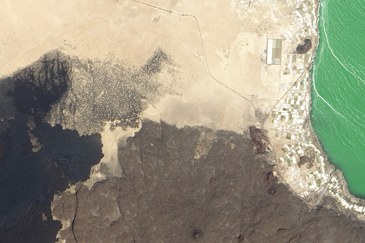
Every month on Earth Matters, we offer a puzzling satellite image. The July 2014 puzzler is above. Your challenge is to use the comments section to tell us what part of the world we are looking at, when the image was acquired, what the image shows, and why the scene is interesting.
How to answer. Your answer can be a few words or several paragraphs. (Try to keep it shorter than 200 words). You might simply tell us what part of the world an image shows. Or you can dig deeper and explain what satellite and instrument produced the image, what spectral bands were used to create it, or what is compelling about some obscure speck in the far corner of an image. If you think something is interesting or noteworthy, tell us about it.
The prize. We can’t offer prize money, but, we can promise you credit and glory (well, maybe just credit). Roughly one week after a puzzler image appears on this blog, we will post an annotated and captioned version as our Image of the Day. In the credits, we’ll acknowledge the person who was first to correctly ID the image. We’ll also recognize people who offer the most interesting tidbits of information about the geological, meteorological, or human processes that have played a role in molding the landscape. Please include your preferred name or alias with your comment. If you work for or attend an institution that you want us to recognize, please mention that as well.
Recent winners. If you’ve won the puzzler in the last few months or work in geospatial imaging, please sit on your hands for at least a day to give others a chance to play.
Releasing Comments. Savvy readers have solved some of our puzzlers after only a few minutes or hours. To give more people a chance to play, we may wait between 24-48 hours before posting the answers we receive in the comment thread.
North west U.S. after the forest fires
Purely guessing..
This is a true colour image taken with a satellite such as Landsat. Spectral bands being RGB, pixel size ~ 30m.
The ocean/sea is represented by the greenish colour seen on the right. This sea has a rippling pattern occurring due to windflow. The beige land cover is sand, the brown land cover is rocky terrain.
I would guess that this image is taken somewhere near Egypt/Sudan as it appears to be of a rocky desert.
What I find intriguing s the black land cover to the right. It cannot be another ocean/sea as it has not got the rippling texture of the ocean to the right. This land cover also lacks nearby urban development. This indicates that it is not an attractive area. Due to the rough texture present in this area I would hazard a guess that this is a form or rocky volcanic terrain. Less likely; oil.
This image is of the South-Western part of lake Afrera in Northern Ethiopia. The lake is located in the Danakil depression area where three tectonic plates are present. The darkof area might be the result of a near by volcano. The lake is characterized by its high salinity making it an acidic medium where a very rare species of fish live. This area is one of the driest, hottest (yearly average), and lowest points in Africa.
nice game. but I think it get hard
fight
gulf maroco afrika
Dead sea jordan/Israel
Dead sea jordan / Israel
Image shows Lake Afrera (right) and Nabro Strato Volcano on the left – Afar Zone 2 Ethiopia, 13.195176, 40.806911
I would guess this was taken in 2011 after the volcano erupted killing 7 people (or reported to be up to 31 people). The eruption released the highest ever observed sulfur dioxide levels from Earth’s orbit.
Possibly taken using EO-1 satellite
You are right. Looks great on google earth. You can follow the lava flows
It looks like the coast of Libya.
Se trata de un paisaje colinoso, marino y volcanico a la vez, en la costa oeste de Africa, por lo que el mar peude ser el Indico. La poblacion alli asentada parece un campamento abandonado, no se nota presencia activa de poblacion. Se puede deducir que las arenas van subiendo a las colinas producto de viento.
Larssen B ice shelf disintegrating, Antarctica. Was it… 2011?
SW coast of Lake Afrera and adjacent volcanic fields in northern Ethiopia
Looks like Ethiopia shoreline and inland mountains.
Location is Lake Afrera, Ethiopia. The lake has extremely high salinity and is in a region of active volcanic activity. Can see evidence of volcanic eruptions to the W of the lake. The recent eruption of Nabro (to the east) in 2011 contaminated the lake with sulfuric acid, making the salt inedible (cred:Wiki).
I’s part of the Dead Sea region. Shown are the desert, the lake surface and rock formations.
NE part in Africa near to Red Sea, but it’s a lake (I don’t know which name it is, the black color could be a most younger basalt volcanic flow on N direction, the brown one, another one or the most older before the mentioned, the gray o like gray or black stains on sand are by weathering basalt just rigth over on.. All the white or ligth color flat valley sandy land with growing cultive areas (squares) next to the lake, the green color on wather shoot be a salty wather reservoir, all this consider Nort is on up direction. Thanks about your nice pictures, very nice interest geology land.
NE to East direction younger volcanic flow basalt.
Clues: Lava fields in the lower half of the image are relatively recent. So the source may still be active. The lake’s odd coloring indicates it may be a salt lake or very full of algae. The irregular white “fields” could be salt evaporation plots. The irregular shapes indicate that this may be “old world” organic rather than a modern development.
Conclusion:
Southern End of Lake Afrera
Tidbits:
Lake Afrera is a saline inland lake in Northern Ethiopia. Though mined for centuries, the salt is now inedible.
The volcano Afdera erupted in 1907 and (I think) created the lighter lava fields in the south. The darker lava looks to be from Mt Alayta which erupted later. Both of which are part of the rift valley system further south. Cool!
Iceland. the inside, where a lake and the ocean alomost meet.
Iceland, can see a vulcano , a lake and ocean.