
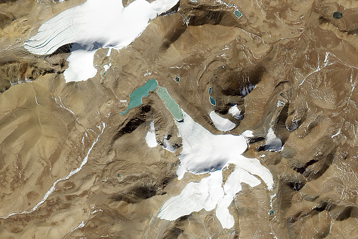
Each month, Earth Observatory offers up a puzzling satellite image here on Earth Matters. In celebration of Earth Month 2013, we’re upping the ante. We are going to release a new puzzler image every day this week. The second image is above. Your challenge is to use the comments section to tell us what part of the world we are looking at, when the image was acquired, and why the scene is interesting. We’ll post the answer to all five puzzlers at 6 p.m. EST on Friday, April 26.
How to answer. Your answer can be a few words or several paragraphs. (Try to keep it shorter than 200 words). You might simply tell us what part of the world an image shows. Or you can dig deeper and explain what satellite and instrument produced the image, what spectral bands were used to create it, or what is compelling about some obscure speck in the far corner of an image. If you think something is interesting or noteworthy, tell us about it.
The prize. We can’t offer prizes, but we can promise you credit and glory (well, maybe just credit). Later this week when we post annotated and captioned versions of the puzzler images as our Image of the Day, we will acknowledge the people who were first to correctly ID the images. We’ll also recognize people who offer the most interesting tidbits of information. Please include your preferred name or alias with your comment. If you work for an institution that you want us to recognize, please mention that as well.
Recent winners. If you’ve won the puzzler in the last few months, look at this week as a new challenge — can you get all five image locations?
Good luck!
glacier.
Glacial lakes in a mountain system, I’m guessing somewhere in the Andes since it seems a little weathered, so perhaps in the Atacama desert?
High desert… Asia…. Mongolia… China? Mid-day (summer, perhaps), glacier formed lakes, headwaters of Yangtze (?)
Glacial rock flour coloring high elevation lakes in the steppes of Tibet
Looks glacial. No idea where! Greenland?
Could it be somwehere in Iceland?
Desert , mongolia, summar, salt water
Picture of white pigeon flying over blue-headed duck, splashing through a puddle. Clearly.
It is some sort of waste of a mine of any element. I guess.
I think it shows mountains with snow peaks
Frozen lakes with a little bit of fresh liquid wter connected to it. Probably towards the dirrection of mountains on the Weastern Coast.
Northern Tibet
1°) The glacier (mid) and the permantent ice, and without vegetation, indicate environment of high mountain.
2°) The region was a lot of glaciers (there is cirques, horns, edges).
3°) The two major lakes are origen of glacier fusion (dammed by two? moraines) and its light blue is due to the “glacier flour”.
4°) The rocks probably are sedimentary and volcanics?
5°) Summer to spring
Can be the range of Himalaya or the Andes.
I think that the image belongs to the Andes. North of Chile, Bolivia, or Northwest of Argentina
Instrument LANDSAT!!! real colour
Whats left of the Aral Sea?
Glaciers on the Andes? Taking ice core for climate study?
-Comencemos por analizar la imagen. Por lo que apreciamos se encuentra a gran altitud por la carencia de vegetación y por la presencia de glaciares y nieve, aunque no presenta gran cantidad de la misma, por consiguiente denota cierta aridez, o sea falta de humedad en el ambiente. Sólo algunos lugares de la Tierra responden a estas características. Por un lado pude ser la provincia de Ushuaia en Argentina, por su elevación y aridez. Aunque por otra parte podría ser Nepal, por la altitud en la que se presenta y la poca humedad que recibe al ser atrapada gran parte por la cordillera de Sir William Everest.
Antarctic Dry Valleys. Must have been acquired in Austral summer, so December/January plus or minus a few months. Relatively high resolution indicates more recent sensors – maybe ALI? It is interesting because the vast majority of Antarctica is covered in ice, but this region is too dry to sustain permanent ice/snow cover.
Interesting! could be the Antarctic peninsula?
Chile, Andes, picture is oriented in traditional top of picture is north. I would say the photo was taken sometime between Oct and Dec. and covers the higher elevations. Don’t know the glaciers in that area so can not be specific in location.
Afghan mountains
Northern part of the Atacama Region, Chile
Land appears to be old volcanic terrain where a relatively quick snow melt occurs. Maybe some northern latitude country such as Alaska?
Prince Charles Mountains, Antarctica
Assuming the image is oriented with north at the top, the shadows indicate that the location would be somewhere in the northern hemisphere. Probably somewhere in central Asia.
Disregard that, was confused, shadows actually indicate the Southern Hemisphere 🙂
Actually hard to tell, think is the northern hemisphere after all!
Southern Hemisphere Summer (shadows)… Shadows too short for Antarctica (even in high summer), Very Arid.
Almost certain it’s Andes since lack of visible vegetation and land forms indicate very high altitude/extreme aridity… Near site of Atacama Large Millimeter Array (ALMA)?
Two Glacial lakes just wet of Gyesar Co, Ngari, Xizang (Tibet), China
Lat 30°20’31.63″N
Lon 84°35’26.74″E
Bravo! Well done!
NICE! Great job!
Nice! I spent hours on Google Earth looking for this…..I was soooo close!