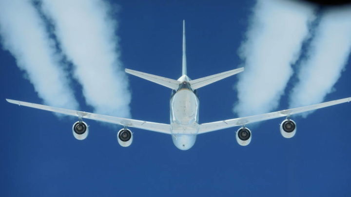
The DC-8’s four engines burned either JP-8 jet fuel or a 50-50 blend of JP-8 and renewable alternative fuel made from camelina plant oil. Credits: NASA/SSAI Edward Winstead
Taking Some of the Search Out of ‘Search and Rescue’
NASA engineers are developing prototypes of second-generation locator beacons. The little devices have been used by pilots, mariners, and hikers since the 1970s to relay distress signals in times of emergency. Until now, those beacons have had a 2-kilometer (1 mile) radius. The new beacons will pinpoint location within a 140-meter radius—that’s more than 10 times more precise.
Small Satellites Will Track Big Storms
Atlantic hurricane season has just begun—and the CYGNSS mission has it covered. The constellation of eight mini-satellites, launched into low-Earth orbit in December 2016, measures surface winds using GPS signals reflected from the ocean surface. The data will help track storms as they grow, giving forecasters a better sense of storm intensity.
Cleaner Contrails?
Long a source of wonder (and occasional conspiracy theories), the white plumes that trail behind aircraft are a focus of study for NASA scientists testing the effects of biofuels. A new study shows that alternative fuels made from plant oils can cut down on particle emissions in jet exhaust by as much as 50 to 70 percent. From the news release:
Contrails are produced by hot aircraft engine exhaust mixing with the cold air that is typical at cruise altitudes several miles above Earth’s surface, and are composed primarily of water in the form of ice crystals…Researchers are most interested in persistent contrails because they create long-lasting, and sometimes extensive, clouds that would not normally form in the atmosphere, and are believed to be a factor in influencing Earth’s environment.
A Different Kind of Scat
Scientists have a new tool for measuring both ocean winds and water currents. Tested on airborne missions this spring, DopplerScatt is a cousin of QuickSCAT and RapidScat, which used a scatterometer to measure the “roughness” of the ocean surface and determine the direction and intensity of wind. DopplerScat adds a doppler radar to the package, allowing scientists to measure the speed and direction of the moving water. The instrument is another potential tool to measure currents along shipping routes or predict the direction that oils and other slicks might move.
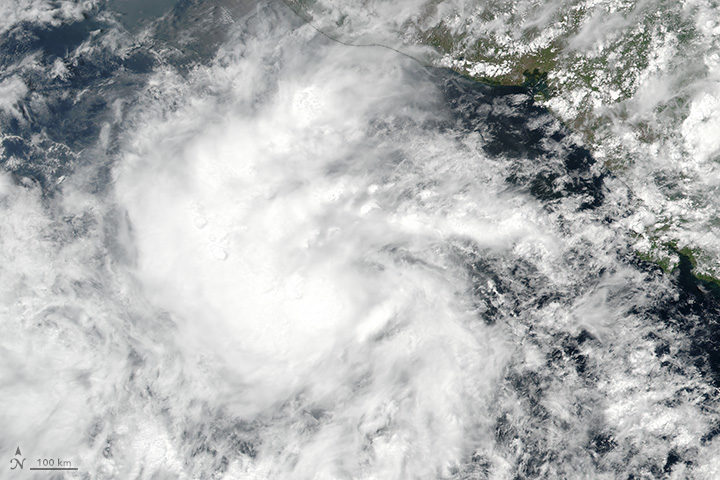
On May 9, 2017, the Visible Infrared Imaging Radiometer Suite (VIIRS) on the Suomi NPP satellite captured this image of a tropical depression off Central America. Later that day, the storm became Tropical Storm Adrian. The storm was not very well organized, as evidenced by its amorphous appearance. Despite warmer-than-average ocean surface temperatures, wind shear would keep the storm from strengthening into a hurricane.
But it wasn’t the storm’s strength that was worth noting; it was its timing. Adrian earned the title of “earliest tropical storm to form in the East Pacific” since reliable records began in 1970. It takes the top spot from Tropical Storm Alma, which formed on May 12, 1990. Read more about Adrian on the Weather Underground Category 6 blog here and here.
