For the second year in a row, fierce fires have burned throughout Bolivia. They are the product of a prolonged drought, which has supercharged the fires that are lit seasonally by farmers and ranchers to maintain grazing land and to clear forest and woodlands for agricultural production.
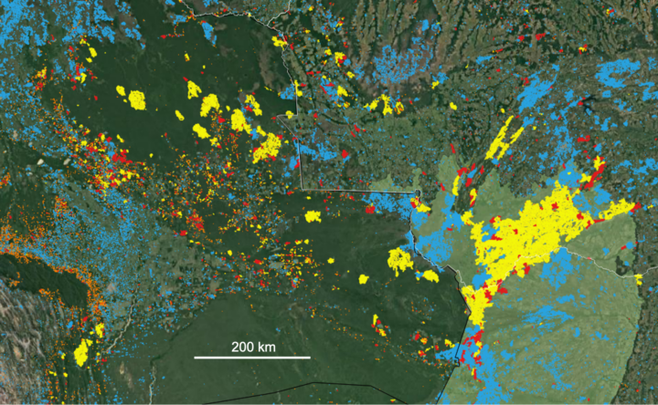
Sensors on NASA and NOAA satellites – including the Moderate Resolution Imaging Spectroradiometer (MODIS) and Visible Infrared Imaging Radiometer Suite (VIIRS) – map where fires are actively burning on Earth each day. For instance, the map from NASA’s Fire Information for Resource Management System (FIRMS) below shows all of the fire detections in Bolivia that VIIRS observed on October 16, 2020.
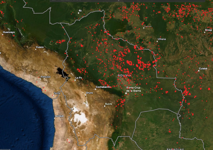
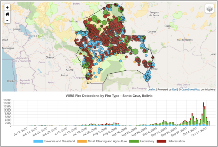
But not all the red dots on the map are of equal ecological significance. As these screenshots (below) from NASA’s Amazon fire dashboard make clear, there is a lot of variety in the types of fires that have burned in Bolivia in recent months, and they vary by region and ecosystem.
Many fires in the region are short-lived grassland and savanna fires; these burn vegetation that regrows quickly, and there is usually little ecological damage and minimal carbon emissions. Likewise, many others are small-scale land clearing and agricultural fires that do not cause substantial new damage to intact tropical forests.
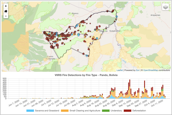
On the other hand, some of those red dots are long-lasting, intense deforestation fires that were lit specifically to burn trees as part of land-clearing processes. These fires turn patches of tropical forests into pasture or cropland, fragmenting the remaining forests and altering ecosystems for decades.
Others are low-intensity understory fires that typically begin in cleared areas as agricultural fires, but then escape into neighboring forests. Even a low-intensity fire may kill half of the trees, unleashing a cascade of ecological changes that can transform tropical forests into open-canopy woodlands over time.
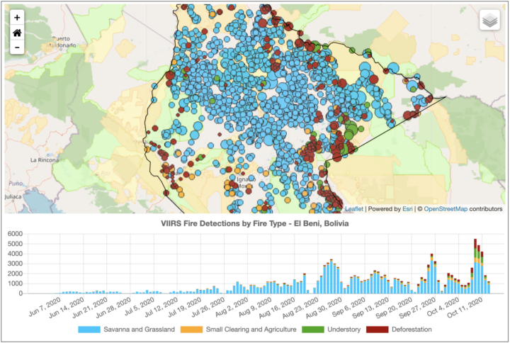
The charts above highlight the types and trends of fire type for three states (departments) in Bolivia. The northerly Pando department is still dominated by intact tropical rainforest. Satellites have detected large numbers of deforestation and agricultural fires burning there since August 2020, particularly along Highway 13. With more grasslands and fewer forests, El Beni has a higher proportion of the less-damaging fire types. The large Santa Cruz department, home to the Chiquitano dry forest and Pantanal grasslands, has comparatively large numbers of understory and grass fires.
“The goal of our new classification system is to provide real-time information on what types of fires are burning across the Amazon region every day. With thousands of individual fires burning at this point in the dry season, the question is how to prioritize regional efforts for fire suppression to best protect communities and ecosystems. Understory fires are particularly devastating in Amazon forests that are not adapted to fire,” said Douglas Morton, chief of the Biospheric Sciences Laboratory at NASA’s Goddard Space Flight Center. “However, it is worth pointing out that our real-time classification system for Amazon fires is not the only way of categorizing fires. We are working closely with state and national agencies across the Amazon to improve the classification, based on feedback from field crews.”

NASA Earth Observatory images by Joshua Stevens, using VIIRS data from the Suomi National Polar-orbiting Partnership and the Fire Information for Resource Management System (FIRMS). The map shows fires detected on November 2, 2016.
When I was writing about the crop fires in northern India last fall, it was obvious that 2016 was a pretty severe burning season. For several weeks, large plumes of smoke from Punjab and Haryana blotted out towns and cities along the Indo-Gangetic plain in satellite images.
But I didn’t realize just how severe the fires were until Hiren Jethva, an atmospheric scientist at NASA Goddard Space Flight Center, crunched the numbers. By analyzing satellite records of fire activity, he found that the 2016 fires were the most severe the region has seen since 2002 in regards to the number of fire hot spots satellites detected. In regards to the amount of smoke detected, the 2016 burning was the most severe observed since 2004. He used data from the Moderate Resolution Imaging Spectroradiometer (MODIS) sensor on Aqua and the Ozone Monitoring Instrument (OMI) on Aura to reach his conclusions.
Smoke and fire in northern India have become common in October and November during the last three decades because farmers increasingly use combines to harvest rice and wheat. Since these machines leave stems and other plant residue behind, farmers have started to use fire to clear the leftover debris away in preparation for the next planting.
For more details about how 2016 compared to past years, see the charts below, which Jethva prepared. His explanation for each chart is in italics.
Aqua Detected More Fires in 2016 Than During Any Year Since 2002

Chart by Hiren Jethva based on MODIS data.
The satellite-based sensor MODIS can detect the signal of fire hot spots, also called thermal anomalies, because the signal measured by the sensor in space in the thermal infrared bands appears to be an anomaly compared to the signal emanated from the background land. Since its launch in 2002, the MODIS on NASA’s Aqua satellite has detected thermal anomalies such as wildfires, agricultural fires, and gas flares on a daily basis.
The yearly evolution of total number of fires and Fire Radiative Power (FRP) — the heat energy produced from these fires — detected over Punjab and Haryana showed 2016 to be an anomalous year, with the highest number of crop residue fires (18,707) and the highest FRP in relation to the fires in all other years over the region. In comparison to 2015, the total number of fire hot spots detected over the region in 2016 was 43 percent higher; the difference is 25 percent if the hot spot counts are averaged over the last five years, i.e., 2011-2015. A careful look at the time-evolution of fire counts also reveals an increasing trend in the total number of fires over the region.
Punjab Skies Were Unusually Smoky

Chart by Hiren Jethva based on OMI data.
These fires produced huge amounts of fine aerosol particles and trace gases, which can potentially impact the climate and degrade air quality drastically at ground level. NASA’s A-train sensors such as the Ozone Monitoring Instrument (OMI) on the Aura satellite and the MODIS on Aqua offer capabilities to measure the total amounts of airborne particles. The UV Aerosol Index (UV-AI), which is an excellent indicator of the column amounts of light-absorbing particles in clear as well as cloudy atmospheres, showed 2016 was the smokiest season on record since 2004.
Greener Fields and Larger Harvests Lead to More Fires

Many studies have shown that satellite measurements of the “greenness” of crop fields prior to harvest and crop yield after the harvest are strongly correlated. The normalized difference vegetation index (NDVI), which is derived from satellite measurements of radiation at the red and near-infrared light, is one useful measure of greenness. As seen in the charts above, there seems to be a one-to-one relationship in NDVI measured by the MODIS sensor on Aqua prior to harvest (September) and the total number of fire hot spots observed during harvest season (Oct-Nov). This suggest that the increase in the number of fires is likely related to increasing crop yields.
