Every month on Earth Matters, we offer a puzzling satellite image. The April 2015 puzzler is above. Your challenge is to use the comments section to tell us what part of the world we are looking at, when the image was acquired, what the image shows, and why the scene is interesting.
How to answer. Your answer can be a few words or several paragraphs. (Try to keep it shorter than 200 words). You might simply tell us what part of the world an image shows. Or you can dig deeper and explain what satellite and instrument produced the image, what spectral bands were used to create it, or what is compelling about some obscure speck in the far corner of an image. If you think something is interesting or noteworthy, tell us about it.
The prize. We can’t offer prize money, but, we can promise you credit and glory (well, maybe just credit). Roughly one week after a puzzler image appears on this blog, we will post an annotated and captioned version as our Image of the Day. In the credits, we’ll acknowledge the person who was first to correctly ID the image. We’ll also recognize people who offer the most interesting tidbits of information about the geological, meteorological, or human processes that have played a role in molding the landscape. Please include your preferred name or alias with your comment. If you work for or attend an institution that you want us to recognize, please mention that as well.
Recent winners. If you’ve won the puzzler in the last few months or work in geospatial imaging, please sit on your hands for at least a day to give others a chance to play.
Releasing Comments. Savvy readers have solved some of our puzzlers after only a few minutes or hours. To give more people a chance to play, we may wait between 24-48 hours before posting the answers we receive in the comment thread.
Good luck!
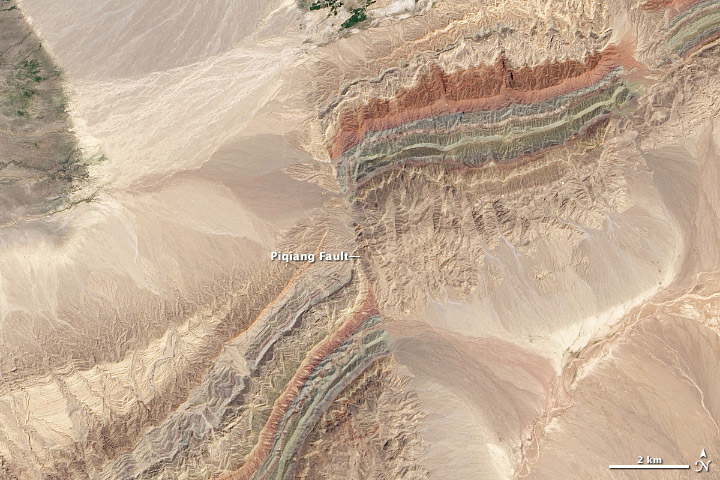
Tournament Earth 2015 has come to a dramatic end. Despite some tough match ups, the colorful faults of Xinjiang fought off a bolt of lightning (as seen from the International Space Station), taking the #2 seed from the art division all the way to the championship.
This year’s victory was a first for an image from a Landsat satellite. In 2014, the Moderate Resolution Imaging Spectroradiometer (MODIS) on Terra captured the winning shot. In 2013, it was the Advanced Land Imager (ALI) on the Earth Observing-1 (EO-1) satellite. This was also the first year that an image not associated with the Canary Islands won the tournament.
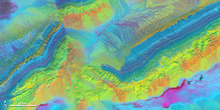
As noted in our original Image of the Day, Piqiang Fault is a northwest trending strike-slip fault that runs roughly perpendicular to a series of thrust faults. The thrust faults are marked by the colorful southeast-to-northeast running ridges. The ridges are offset by about 3 kilometers (2 miles) due to the strike-slip fault. For another perspective on the faults, see how they look in the near infrared and shortwave infrared (below). In the near infrared, variations in mineral content, vegetation, and water cause the patterns of light and dark. Below that, comparing the differences between 3 shortwave infrared bands highlights the mineral geology surrounding the fault.

Though obvious from above, the Piqiang Fault can be a challenge to see from the ground. “You can’t actually see the fault unless you hike into the mountains,” explained Sebastian Turner, a geologist who has conducted studies in the area. If you would like to learn more about the geology of this area, I would recommend looking through Turner’s study or this one by Mark Allen.
Thank you for voting!

The answer to the March 2015 puzzler, most commenters agreed, involved snow and ice and cold climates. A great many guesses correctly zeroed in on far northern latitudes, with surmises about pipelines in Alaska, airport runways in Siberia, railroad sidings, and ice roads on frozen lakes. You can see the full answer and image reveal in our March 22, 2015 Image of the Day.
Reader James Simard was the first to get the location fully correct as the winter road in Canada’s Northwest Territories. James wrote:
The world’s longest ice road connects Yellowknife to three diamond mines: Ekati, Diavik, and Snap Lake. Of the 475 kilometers (300 miles) of ice road, 86 percent of it is across frozen lakes.
The ice road is the only overland supply route for the mines. Each winter, a year’s worth of fuel, construction material, heavy mining equipment, and explosives are trucked to the mines. The road provides the most cost-effective method for transporting these supplies.
However James went a step further and said that it was Landsat 8 image (yes!) from April 10, 2014 (alas, no). It turns out my puzzler choice was something that the USGS Earthshots posted online (and James’ detailed quote is from that page). If I had known the USGS folks had run this before, I would not have selected it as a puzzler. This image is actually a much more recent Landsat 8 image from February 24, 2015. I actually stumbled on it while purusing the daily images from a sister satellite instrument, EO-1’s ALI, but the Landsat image three days later covered more of the winter road. Nice find, James! Clearly I need to comb through the Earthshots page in the future first!
I also want to give a special shout-out to reader Shirley. She also got the right answer, giving the full name of the Tibbett-Contwoyto Ice Road. However, she did have an inside track on the answer. She wrote: “My company works on the road every year.”
On Facebook, many people posted correct answers (including James one minute after he posted the answer here). Some readers locked into the correct answer after recalling episodes of the History Channel’s TV series Ice Road Truckers, which focused on the Tibbett-Contwoyto Ice Road during its first season.
If you would like to know more about the Tibbett-Contwoyo Ice Road, check out the references cited on our Image of the Day answer.

Every month on Earth Matters, we offer a puzzling satellite image. The March 2015 puzzler is above. Your challenge is to use the comments section to tell us what part of the world we are looking at, when the image was acquired, what the image shows, and why the scene is interesting.
How to answer. Your answer can be a few words or several paragraphs. (Try to keep it shorter than 200 words). You might simply tell us what part of the world an image shows. Or you can dig deeper and explain what satellite and instrument produced the image, what spectral bands were used to create it, or what is compelling about some obscure speck in the far corner of an image. If you think something is interesting or noteworthy, tell us about it.
The prize. We can’t offer prize money, but, we can promise you credit and glory (well, maybe just credit). Roughly one week after a puzzler image appears on this blog, we will post an annotated and captioned version as our Image of the Day. In the credits, we’ll acknowledge the person who was first to correctly ID the image. We’ll also recognize people who offer the most interesting tidbits of information about the geological, meteorological, or human processes that have played a role in molding the landscape. Please include your preferred name or alias with your comment. If you work for or attend an institution that you want us to recognize, please mention that as well.
Recent winners. If you’ve won the puzzler in the last few months or work in geospatial imaging, please sit on your hands for at least a day to give others a chance to play.
Releasing Comments. Savvy readers have solved some of our puzzlers after only a few minutes or hours. To give more people a chance to play, we may wait between 24-48 hours before posting the answers we receive in the comment thread.
Good luck!

The answer to the February 2015 puzzler does not involve the stomach or kidney as many readers suggested. But if your answer mentioned the organ associated with breathing—the lung—then you were partially correct. The image shows Bangkok’s “green lung.” That’s the nickname given to Bang Kachao, a lush protected area that has escaped the dense development seen elsewhere in Bangkok, Thailand. Read more about the region in the caption of the March 1, 2015, Image of the Day.
In response to the February 24 blog post announcing the puzzler, Robert van den Helm was the first to correctly name the city and country. Tanatakorn was the first to specify Bang Ka Chao (one of a number of alternate spellings for the area).
Paul Mueller contributed colorful details about the region that he calls home—and indicates that stomach would have also been an acceptable answer:
“It’s my home, Khung Bang Krachao, nicknamed “The Lungs of Bangkok” or, as the locals say in Thai: “Pig’s Stomach”. It is located in a meander in the Chao Phraya River just south of Bangkok. Comprised of six subdistricts with a population of around 10,000 and an area of around 16 square kilometers, it is part of the Phrapradaeng District of Samut Prakan Province. It is an island since there are at least two canals that cut through the “neck” It is also the largest green space in the world next to any city the size of Bangkok or larger, but sadly is being quickly developed. In 1977, the original plan by the government was to buy almost the entire island to preserve it as a green space, but it was only in 1982 that the funding came in, resulting in only a little over ten percent actually being purchased …”
Finally, Rolf Dunker contributed some interesting nuggets of information on Facebook, noting that buildings in the area not to exceed the height of the palm trees.
Thank you for participating in the February puzzler discussion. We look forward to hearing from you again in March!
“Today marks a special anniversary for the NASA family,” Administrator Charles Bolden wrote in a letter to NASA employees.
On March 3, 1915, the U.S. Congress created the National Advisory Committee for Aeronautics (NACA), the organization from which NASA was later created in 1958. Bolden notes that NACA was initially formed because political leaders at the time were concerned that the United States was losing its edge in aviation technology to Europe, where World War 1 was raging.

One of NACA’s missions was to “supervise and direct the scientific study of the problems of flight with a view to their practical solution.” Research by NACA funded engineers led to fundamental advances in aeronautics that enabled victory in World War II, spawned a world-leading civil aviation manufacturing industry, propelled supersonic flight, supported national security, and laid the foundation for modern air travel and the Space Age. Many names we know from the early days of space exploration got their start at the NACA – including Robert Gilruth, Hugh Dryden, Chris Kraft, Gene Kranz and Neil Armstrong, among many others. A number of the laboratories and wind tunnels built in the NACA era are still at work today.
You can learn more about NACA by visiting this page on the main NASA web site. And you can watch pieces of the centennial symposium here.
Every month on Earth Matters, we offer a puzzling satellite image. The February 2015 puzzler is above. Your challenge is to use the comments section to tell us what part of the world we are looking at, when the image was acquired, what the image shows, and why the scene is interesting.
How to answer. Your answer can be a few words or several paragraphs. (Try to keep it shorter than 200 words). You might simply tell us what part of the world an image shows. Or you can dig deeper and explain what satellite and instrument produced the image, what spectral bands were used to create it, or what is compelling about some obscure speck in the far corner of an image. If you think something is interesting or noteworthy, tell us about it.
The prize. We can’t offer prize money, but, we can promise you credit and glory (well, maybe just credit). Roughly one week after a puzzler image appears on this blog, we will post an annotated and captioned version as our Image of the Day. In the credits, we’ll acknowledge the person who was first to correctly ID the image. We’ll also recognize people who offer the most interesting tidbits of information about the geological, meteorological, or human processes that have played a role in molding the landscape. Please include your preferred name or alias with your comment. If you work for or attend an institution that you want us to recognize, please mention that as well.
Recent winners. If you’ve won the puzzler in the last few months or work in geospatial imaging, please sit on your hands for at least a day to give others a chance to play.
Releasing Comments. Savvy readers have solved some of our puzzlers after only a few minutes or hours. To give more people a chance to play, we may wait between 24-48 hours before posting the answers we receive in the comment thread.
Good luck!

Photo © Alex Cornell.
Icebergs are white, right? Well, no, not completely. As seen in this shot (above) of a recently-flipped iceberg, their undersides can come in spectacular shades of blue and green. The photograph was captured in Cierva Cove, Antarctica, by videographer Alex Cornell during a family vacation. “[It] had this arresting alien-green color to it,” Cornell said of the iceberg in an interview with Universe Today. “It looked a lot more like a parked spacecraft than a floating iceberg.”
When icebergs look white, it is because compressed snow at their surfaces contain large numbers of tiny air bubbles and other reflective particles that tend to reflect all wavelengths of visible light equally. When ice gets compressed—such as when it is trapped under water—the air bubbles and other reflective particles get squeezed out and washed away, leaving purer ice behind. When light encounters pure ice, it can penetrate deep into it rather than reflecting off the surface. As light moves through ice, longer wavelengths (red and yellow) tend to be absorbed most readily, leaving shorter-wavelength green and blue light to reflect back. This “leftover” blue and green light is what gives the undersides of icebergs their remarkable color.
As impressive as it is to see a close-up view, spotting blue ice is not that uncommon. In 2012, we published an aerial photograph with a striking patch of blue ice. Blue ice also shows up regularly in satellite imagery, such as this image acquired by the Advanced Land Imager on EO-1 in 2011.

To learn more about the color of icebergs, check out these stories from WebExhibits, the National Snow & Ice Data Center, and Seed. PetaPixel has also published an interesting guest blog post in which Cornell explains how he produced and distributed the photographs from start to finish. You can find more shots of the flipped berg on his website and Instagram page.
Cornell’s images were not the only jaw-dropping iceberg photographs I noticed this week. On Tuesday, Antarctic Sun editor Peter Rejcek pointed out that the U.S. Antarctic Program had added several new iceberg photographs to their photo library. The images below show an overturned iceberg (with some penguins on top) that contains centuries of windblown sediments and minerals. It really is the stuff of dreams.

Photograph by Ethan Norris, National Science Foundation.

Photograph By: Ethan Norris, National Science Foundation
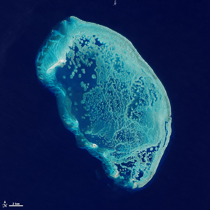
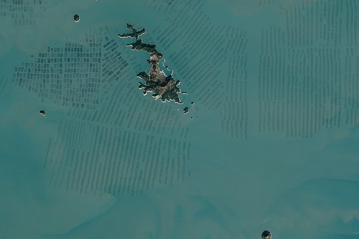
The January 2015 puzzler (top image) might look like bacteria in a petri dish—many guesses played off some variation of that theme. However, if you answered “coral reef,” you were on the right track.
Alexandre Mathieu was the fist to submit a comment to our Earth Matters blog suggesting that the image was a reef. There were also some good guesses on Facebook, such as this post (and poem!) from Clinton Rivers:
This looks like a coral reef
Like Great Barrier or perhaps BelizeA sign from space Of co-operation!
Down below in the coral nationPolyps grow and work together
With a tiny algae called zooxanthellaeTheir carbon capture is solar powered
In warm waters you may see their towersTogether they can build a home
Lots of them a reef or domeAn example for us fresh from the ocean
To live on this earth in Symbiosis
The puzzler, however, proved too obscure for anyone to correctly identify the reef’s location. The puzzle image showed the middle portion of Arrecife Alacranes (bottom image)—a reef in the southern Gulf of Mexico, about 100 kilometers (60 miles) north of Progresso, Mexico. Read the Image of the Day caption to learn more.
It’s rare for a puzzler to stump all of our savvy readers. That’s not our goal, but it’s a fine line between images that are too easy and too hard. Had we cropped the image to include any of the five small islands in the area, we would likely have been flooded with correct answers almost immediately! Tune in next month for a puzzler that will likely be a bit more identifiable.
Every month on Earth Matters, we offer a puzzling satellite image. The January 2015 puzzler is above. Your challenge is to use the comments section to tell us what part of the world we are looking at, when the image was acquired, what the image shows, and why the scene is interesting.
How to answer. Your answer can be a few words or several paragraphs. (Try to keep it shorter than 200 words). You might simply tell us what part of the world an image shows. Or you can dig deeper and explain what satellite and instrument produced the image, what spectral bands were used to create it, or what is compelling about some obscure speck in the far corner of an image. If you think something is interesting or noteworthy, tell us about it.
The prize. We can’t offer prize money, but, we can promise you credit and glory (well, maybe just credit). Roughly one week after a puzzler image appears on this blog, we will post an annotated and captioned version as our Image of the Day. In the credits, we’ll acknowledge the person who was first to correctly ID the image. We’ll also recognize people who offer the most interesting tidbits of information about the geological, meteorological, or human processes that have played a role in molding the landscape. Please include your preferred name or alias with your comment. If you work for or attend an institution that you want us to recognize, please mention that as well.
Recent winners. If you’ve won the puzzler in the last few months or work in geospatial imaging, please sit on your hands for at least a day to give others a chance to play.
Releasing Comments. Savvy readers have solved some of our puzzlers after only a few minutes or hours. To give more people a chance to play, we may wait between 24-48 hours before posting the answers we receive in the comment thread.
Good luck!
