
Photo by Adam Voiland. Taken from Rodeo Beach in Marin County, California, in the evening on December 14, 2015.
If you have ever stood on a beach before sunset and gawked at a gleaming line of light extending toward the horizon, you have seen a glitter path.
What causes this spectacular optical phenomenon? Glitter paths are made up of many bright points of light reflecting off tiny ripples, waves, and undulations on the water surface and back at a sensor (for instance, a camera or human eye). Together, these points of light make up areas of sunglint. The appearance of glitter paths on water varies depending on the height of the Sun above the horizon, the height of the surface waves, and the position of the observer.
For instance, if the Sun had been directly overhead and above perfectly calm water, I would have seen a circular reflection that looked much like the Sun in the sky. However, when I took this photograph from Rodeo Beach near sunset in December 2015, the reflection appeared as a long elliptical line of light because the Sun was quite low in the sky. Note how much the roughness of the water surface affected the glitter path. Near the shore, where waves had just broken and the water surface was filled with foam, the glitter path was significantly wider than it was in the smoother waters farther off shore.

NASA image acquired by the Moderate Resolution Imaging Spectroradiometer (MODIS) on the Terra satellite on the morning of June 22, 2015.
Sunglint is visible from space as well. In the satellite image of California above, which the Terra satellite captured on the morning of June 22, 2015, notice the line of light running over the Pacific Ocean. This line of sunglint traces the track of Terra’s orbit. If the ocean surface had been completely smooth, a sequence of perfect reflections of the Sun would have appeared in a line along the track of the satellite’s orbit. In reality, ocean surfaces are chaotic and often in motion due to the constant churn of waves and winds. As a result, light reflecting off the surface was scattered in many directions. This left the blurred, washed out line of light along the satellite’s orbital track that you see here instead.
You can learn more about sunglint and glitter paths from stories by Darryn Schneider, Atmospheric Optics, Joseph Shaw, Richard Fleet, NASA Earth Observatory, and Earth Science Picture of the Day.
Editor’s Note: Ground to Space is a recurring series of posts on NASA Earth Observatory’s Earth Matters blog that pairs ground photography and satellite imagery of the same feature or phenomenon. If you have a photograph that you think would be a good candidate, please email Adam Voiland.
Our March 17, 2016, Image of the Day offered a satellite perspective on how sand mining has changed the coastline of Poyang Lake, the largest freshwater lake in China. The photographs below provide a view of sand mining from the ground. James Burnham, an ecologist with the University of Wisconsin and the International Crane Foundation, took the photos while conducting field research on wintering waterbirds at Poyang Lake. “Sand mining has compromised the ecological integrity of the lake by contributing to less predictable seasonal water fluctuations and to a series of recent low water events,” he said. “This is a lake that hosts 98 percent of the endangered Siberian Cranes and Oriental White Storks, as well as a significant number of over a dozen other endangered waterbirds in the winter.”

Barges full of sand. Photo Credit: James Burnham, University of Wisconsin/International Crane Foundation.

Sand dredging boat. Photo Credit: James Burnham, University of Wisconsin/International Crane Foundation.

Siberian Crane unison call at Mei Xi Hu in Poyang Lake Nature Reserve. Photo Credit: James Burnham, University of Wisconsin/International Crane Foundation.

Siberian Crane family group at Mei Xi Hu in the Poyang Lake Nature Reserve. Photo Credit: James Burnham, University of Wisconsin/International Crane Foundation.
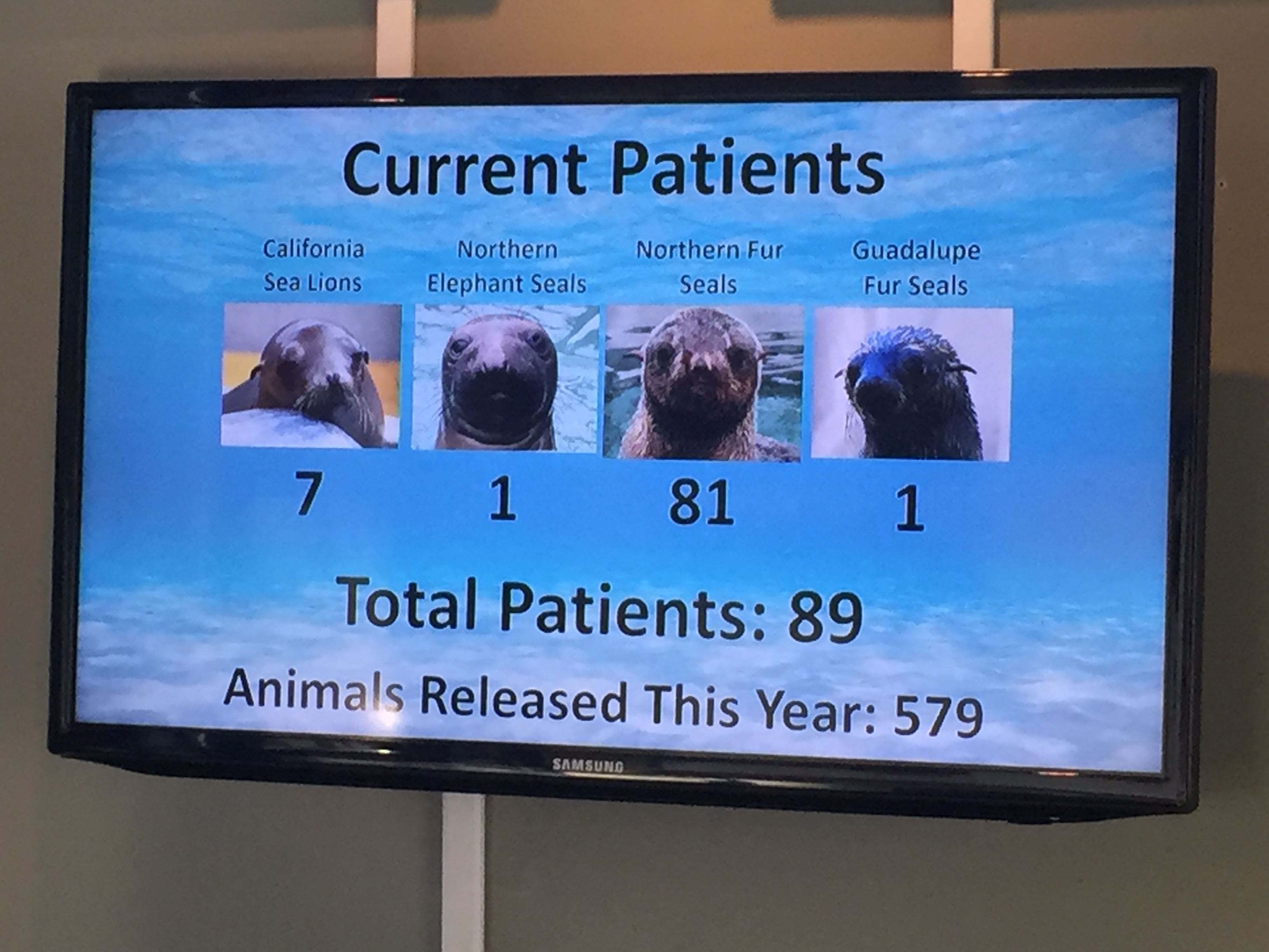
While I was in San Francisco in the fall of 2015, I headed across the Golden Gate Bridge to take a tour of The Marine Mammal Center, a nonprofit veterinary research hospital in Sausalito, California. I had heard that a blob of unusually warm water off the Pacific coast had taken a toll on marine life and caused an increase in the number strandings.
When I visited on December 16, 2015, the hospital was taking care of 81 northern fur seals, 7 California sea lions, 1 northern elephant seal, and 1 Guadalupe fur seal. That is a lot of northern fur seals—three times more than the center rescued the previous year and more than twice the previous record, which was set in 2006.
While sea lions, elephant seals, and Guadalupe fur seals were scarce when I visited, had I come earlier in the year there would have been plenty of these species as well. By February 2015, the center had rescued record numbers of starving sea lion pups; by April, they were dealing with record numbers of elephant and harbor seals; by June, they had taken in five times the normal number of Guadalupe fur seals.
A northern fur seal resting on a warming mat. Photo by Adam Voiland.
The photograph above shows one of the northern fur seals resting on a warming mat. “Northern fur seals are smaller, furrier and feistier than the California sea lion pups we rescued earlier this year,” noted Shawn Johnson, the director of veterinary science at The Marine Mammal Center, in a November press release. “But otherwise the scene here is the same—our rescue trucks continue to arrive day after day with more starving pups in need of our care.” By the end of the year, the center had rescued 1,800 animals, breaking nearly every record in the facility’s 40-year history.
What was causing all of the trouble? Most marine scientists think the warm water blob in the northeast Pacific was a key culprit. The warm water was driven by the emergence of an unusually strong and persistent ridge of atmospheric high pressure in the northeastern Pacific Ocean. The feature, which was so unrelenting that meteorologists took to calling it the Ridiculously Resilient Ridge, weakened winds in the area enough that the normal wind-driven churning of the sea eased.
Those winds usually promote upwelling, which brings deep, cool water up toward the surface; instead, the resilient ridge shut down the ocean circulation, leaving a large lens of unusually warm surface water in the northeastern Pacific. Upwelling brings dissolved nutrients to the surface, so the slowdown in upwelling meant many animals had less to eat. In addition, the warm water extended the time that certain type of algae bloom produced toxins that can cause serious health problems for marine mammals.

![]()
The maps below show sea surface temperature anomalies in the Pacific in July 2015. Large patches of warm water dominated the Gulf of Alaska and along the California coast. The map is based on data collected by the U.S. Navy’s WindSAT instrument on the Coriolis satellite and the AMSR2 instrument on Japan’s GCOM-W. Note that the maps do not depict absolute temperatures; instead, they show how much above (red) or below (blue) water temperatures were compared to the average from 2003 to 2012.
The good news it that the blob has finally broken up. By January 2016, more seasonable temperatures had returned to the northeast Pacific, thanks to the strong El Niño in the equatorial Pacific. The breakup of the warm blob came as no surprise to weather watchers. In September 2015, Clifford Mass, a University of Washington atmospheric scientist, explained in his blog that El Niño generally brings lower-than-normal sea surface pressures to the eastern Pacific—the opposite of the systems that sustained the blob. By mid-December 2015, around the time that I was visiting the Marine Mammal Center, Mass declared that the blob was dead.
However, remnants of the warm blob still persist. “There are significant temperature anomalies extending down to a depth of about 300 meters. So while the weather patterns the past few months have not been that favorable to warming, it will take a while for all of the accumulated heat to go away,” explained Nicholas Bond, a University of Washington meteorologist and Washington state’s climatologist. That means impacts on marine life and on weather in the Pacific Northwest could linger, though Bond does not think the blob will return in the near term.
The type of type of algae that has caused harmful blooms is Pseudonitzschia, which produces the neurotoxin domoic acid. The Marine Mammal Center is where scientists first discovered (in 1998) that domoic acid could be toxic to marine mammals. The toxin accumulates in shellfish, sardines, and anchovies, common food sources for marine mammals. Exposure to domoic acid affects the brains of mammals; it can cause them to become lethargic, disoriented, and have seizures that sometimes result in death.
High levels of domoic acid likely contributed to the record number of marine mammal strandings. Since the toxin can also affect humans and was found in the meat of commercial fish and crabs (rather than just the guts), authorities also closed major fisheries including Dungeness and rock crab, anchovy, oyster, razor clams, and mussels in 2015.
In many areas, domoic acid remained a concern in mid-February 2016. Though the situation has improved somewhat, California’s commercial dunegrass crab season will remain closed until more of the coast is clear of the toxin, according to the San Francisco Chronicle.
Meanwhile, National Oceanic and Atmospheric (NOAA) scientists recently reported that domoic acid is present in Alaskan marine food webs in high enough concentrations to be detected in marine mammals such as whales, walruses, sea lions, seals, porpoises and sea otters. “Since 1998, algal toxin poisoning has been a common occurrence in California sea lions in Central California. However, this report is the first documentation of algal toxins in northern ranging marine mammals from southeast Alaska to the Arctic Ocean,” a NOAA press release said.
“We do not know whether the toxin concentrations found in marine mammals in Alaska were high enough to cause health impacts to those animals. It’s difficult to confirm the cause of death of stranded animals. But we do know that warming trends are likely to expand blooms, making it more likely that marine mammals could be affected in the future,” NOAA research scientist Kathi Lefebvre said.
For more details about the unusual conditions in the Pacific Ocean, see this story from the University of California.
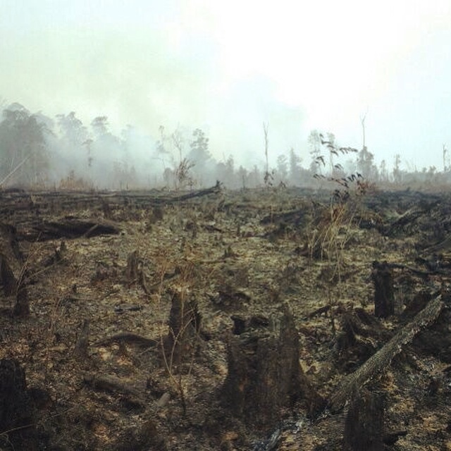
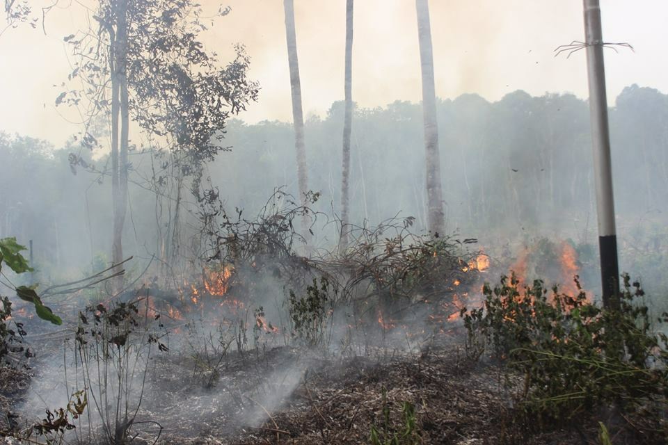
Aftermath of a fire in peatlands on the southwest border of Gunung Palung National Park, West Kalimantan. (Photo courtesy of the Gunung Palung Orangutan Conservation Program).
Cassie Freund is the program director of the Gunung Palung Orangutan Conservation Program, an orangutan protection project in Indonesia. While working on our latest feature story, we asked her what life was like in West Kalimantan during the 2015 fire season, when smoke blanketed parts of Borneo and Sumatra. Peat deposits, El Niño weather, and agricultural activity converged to produce prodigious fires and planet-warming emissions. Read Seeing Through the Smoky Pall: Observations from a Grim Indonesian Fire Season to learn more.
How has the smoke affected you?
I live in the Ketapang district of West Kalimantan. We had some serious fires here, but it wasn’t as bad as in Central Kalimantan, which was basically the epicenter of the disaster. Breathing the smoke wasn’t pleasant, and I didn’t dare open a window or a door in my house because it would just permeate everything.
The smoke also seriously disrupted some of my travel plans. There were no flights into or out of my town for at least a month, so we had to rely on boats or long-distance travel by car.
The smoke also disrupted my work. I do lot in the community and in schools, but September and October were quiet months for us because the schools were not in session. It was too dangerous for students. Adults were not available to participate in our conservation activities and meetings because they either had to stay in the field and guard their crops from fire, or didn’t want to be outside more then necessary.
Have you had health problems as a result of the haze? Do you know people who have?
I had a cough for several weeks. I do know people whose children were sick, and one woman I spoke to has a three-month old baby that she has not taken outside at all because of the smoke. One problem was that there just weren’t enough good masks to go around. During the worst of the pollution, normal surgical masks aren’t enough. But many people don’t own the N95 masks that block out the smoke particles.
Can you describe how the air smelled and tasted during the worst of the burning?
Acrid is the best word to describe it. Peat fires have a pretty distinctive smell. The smoke just goes right to the back of your throat, and makes your eyes sting. People here describe it has having mata pedas, which translates to “spicy eyes.” The smoke looks like morning fog, but it doesn’t dissipate.
A peat fire burns vegetation in the Sungai Laur area of Ketapang district, West Kalimantan. (Photo courtesy of the Gunung Palung Orangutan Conservation Program).
Is there anything else you would like to add?
I am afraid that the next huge hot spots—not this year, but maybe in the future—will be in Papua. And there, as someone has pointed out to me, there are no charismatic species to get people riled up and to motivate them to donate to conservation. There’s just peat. Most of the peatlands there are still intact, too, and they absolutely need to be protected.
You can read blog posts by Cassie Freund about the fires here and here.
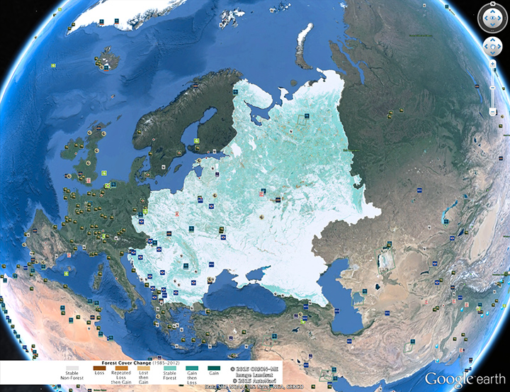
Our July 16 Image of the Day—Changing Forest Cover Since the Soviet Era—features a Landsat-derived map showing how forests have changed in Eastern Europe since 1985. After exploring the three areas we highlighted, I highly recommend browsing the map at full resolution using either Google Earth or GigaPan. The amount of detail you will find is extraordinary. There are dozens of other interesting forest loss and gain hot spots that we could have highlighted. In fact, we may publish additional stories using these data, so please let us know if you are aware of local stories of forest change in eastern Europe that deserve more attention.
While the satellite maps offer invaluable “big picture” perspective, ground photographs really bring the changes to life. Peter Potapov, the University of Maryland scientist who led the mapping effort, passed along a few photographs taken during his field research in Russia. It is one thing to know that a brown pixel in the maps indicate forest loss and the a green pixel indicates gain. It becomes real when you can actually see charred trunks after a forest fire or stands of saplings springing up in abandoned Soviet farm fields.
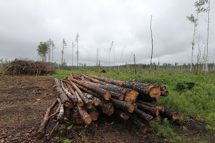
Logging site in the Vladimir region of Russia. Photo Credit: Peter Potapov.
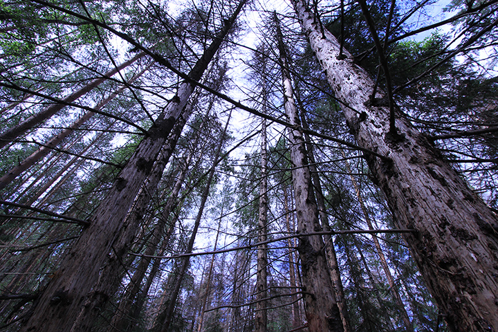
Spruce trees killed by bark beetle in the Vladimir region of Russia. Photo Credit: Peter Potapov.

Charred trunks caused by a forest fire in the Vladimer region of Russia. Photo credit: Peter Potapov
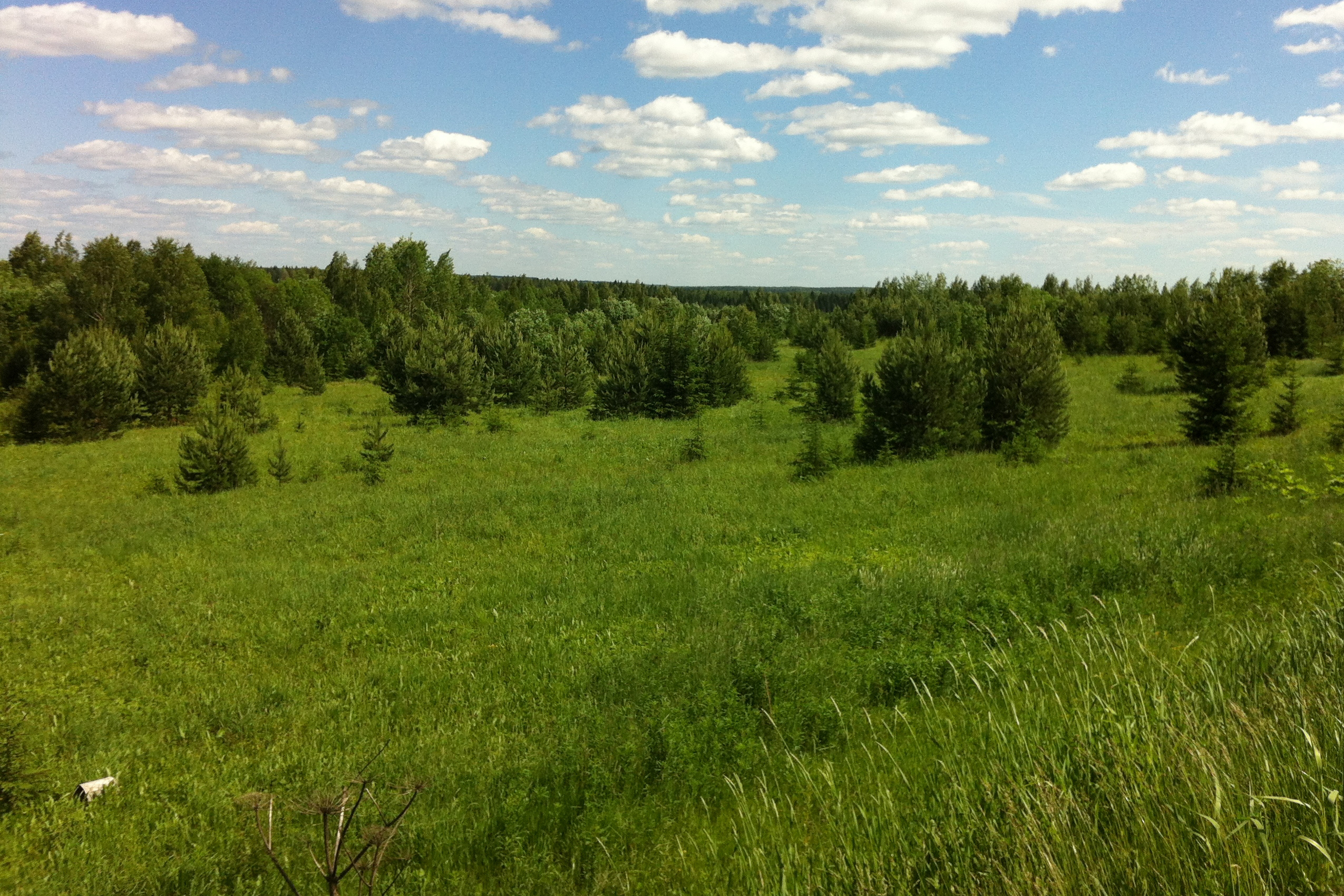
Pine forests in an abandoned pasture in the Vladimir region of Russia. The pine trees are about ten years old. Photo Credit: Peter Potapov.

Birch forest growing on abandoned farmland in the Nizhny Novgorod region of Russia. Photo Credit: Peter Potopov
Early stages of forest recovery in abandoned farmland in the Kirov region of Russia. Photo Credit: Peter Potapov

Photo © Alex Cornell.
Icebergs are white, right? Well, no, not completely. As seen in this shot (above) of a recently-flipped iceberg, their undersides can come in spectacular shades of blue and green. The photograph was captured in Cierva Cove, Antarctica, by videographer Alex Cornell during a family vacation. “[It] had this arresting alien-green color to it,” Cornell said of the iceberg in an interview with Universe Today. “It looked a lot more like a parked spacecraft than a floating iceberg.”
When icebergs look white, it is because compressed snow at their surfaces contain large numbers of tiny air bubbles and other reflective particles that tend to reflect all wavelengths of visible light equally. When ice gets compressed—such as when it is trapped under water—the air bubbles and other reflective particles get squeezed out and washed away, leaving purer ice behind. When light encounters pure ice, it can penetrate deep into it rather than reflecting off the surface. As light moves through ice, longer wavelengths (red and yellow) tend to be absorbed most readily, leaving shorter-wavelength green and blue light to reflect back. This “leftover” blue and green light is what gives the undersides of icebergs their remarkable color.
As impressive as it is to see a close-up view, spotting blue ice is not that uncommon. In 2012, we published an aerial photograph with a striking patch of blue ice. Blue ice also shows up regularly in satellite imagery, such as this image acquired by the Advanced Land Imager on EO-1 in 2011.

To learn more about the color of icebergs, check out these stories from WebExhibits, the National Snow & Ice Data Center, and Seed. PetaPixel has also published an interesting guest blog post in which Cornell explains how he produced and distributed the photographs from start to finish. You can find more shots of the flipped berg on his website and Instagram page.
Cornell’s images were not the only jaw-dropping iceberg photographs I noticed this week. On Tuesday, Antarctic Sun editor Peter Rejcek pointed out that the U.S. Antarctic Program had added several new iceberg photographs to their photo library. The images below show an overturned iceberg (with some penguins on top) that contains centuries of windblown sediments and minerals. It really is the stuff of dreams.

Photograph by Ethan Norris, National Science Foundation.

Photograph By: Ethan Norris, National Science Foundation
