
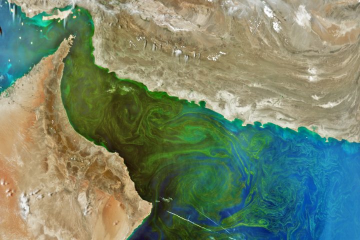
Update on May 21, 2024: This image shows a phytoplankton bloom in the Gulf of Oman. It was acquired on March 17, 2024, less than two months after the launch of NASA’s PACE (Plankton, Aerosol, Cloud, ocean Ecosystem) satellite. Congratulations to Dan Taylor for being the first to correctly identify the bloom and its location. Special mention goes to Robert Taylor for providing a detailed answer, and to Timotheus Fasana, who was the only person to correctly guess the satellite and instrument. Read more about the bloom in our Image of the Day story.
Every month on Earth Matters, we offer a puzzling satellite image. The April 2024 puzzler is shown above. Your challenge is to use the comments section to tell us where it is, what we are looking at, and why it is interesting. The location of this puzzler might be relatively easy to identify, so bonus points go to those who weigh in on the “what” and “why.”
How to answer. You can use a few words or several paragraphs. You might simply tell us the location, or you can dig deeper and offer details about what satellite and instrument produced the image, what spectral bands were used to create it, or what is compelling about some obscure feature. If you think something is interesting or noteworthy, tell us about it.
The prize. We cannot offer prize money or a trip on the International Space Station, but we can promise you credit and glory. Well, maybe just credit. Within a week after a puzzler image appears on this blog, we will post an annotated and captioned version as our Image of the Day. After we post the answer, we will acknowledge the first person to correctly identify the image at the bottom of this blog post. We also may recognize readers who offer the most interesting tidbits of information. Please include your preferred name or alias with your comment. If you work for or attend an institution that you would like to recognize, please mention that as well.
Recent winners. If you have won the puzzler in the past few months, or if you work in geospatial imaging, please hold your answer for at least a day to give less experienced readers a chance.
Releasing comments. Savvy readers have solved some puzzlers after a few minutes. To give more people a chance, we may wait 24 to 48 hours before posting comments. Good luck!
Gulf of Oman and Strait of Hormuz
Strait of Hormuz, Persian Gulf
Persian Gulf, heavy historical importance (trade between Mesopotamia and India&China&Indochina) and currently of strategic importance (Iraq War, Iran-USA Relations).
Harmful algal bloom across the Gulf of Oman. Satellite Imagery (MODIS/VIIRS) was probably acquired on 17th of March, 2024.
This is the Straight of Hormuz and Gulf of Oman. The Arabian Peninsula is to the southwest and Iran to the north in this image. The importance of the region for oil and politics aside, it looks like there might be an algae bloom in the Gulf of Oman as seen by the green swirls in the ocean currents.
I believe that is the Strait of Hormuz and the gulf of Oman
Algae blooms in the Gulf of Oman off the coast of Oman, Iran, and The UAE.
I’ll also add that this can spread all the way to India and depletes much of the region of oxygen.
Straits of Hormuz
Ras Al-Khalmah, United Arab Emirates in the Gulf of Oman
That’s the Musandam Peninsula! I went swimming in the fjords there back in 2017. Amazingly isolated (you can Google “round the bend” to see where the expression came from).
Gulf of Oman. The patterns on the water could be an oil spill, algae, or fresh water. Or something else.
Most likely an oil spill.
This is an easy one — the Straits of Hormuz between Oman and Iran.
Geopolitically and economically significant as a huge amount of carbon footprint oil passes through this straight even today, at a time we can no longer afford to burn oil or gas for their useful efficiency.
The location is easy by the coast line it is the Gulf of Oman
I guess the reason for interest is the satellite (Aqua ? )
Is registering lots of reflectance in the water from an algal blume.
Clean water usually absorbs most wavelengths. Only blue light penetrates to any depth.
The blume is indicating the gyrations of ocean currents in the gulf
Gulf of Oman in the Arabian Sea
The Gulf of Oman turns green twice a year, when an algae bloom the size of Mexico spreads across the Arabian Sea. Scientists studying the algae tie it to climate change that is threatening the food chain and the marine ecosystem.
Scientists trace the blooms to melting ice in the Himalayas, raising temperatures, stronger monsoons, fueling the growth of this algae.
Straits of Hormuz , Yemen coastline..
In the spirit of Jeopardy — Is this the Dead Zone of the Arabian sea?
Straits of Hormuz, Yemen coastline
Yemen Coast
This is the Strait of Hormuz between the Arabian Peninsula and Iran. The UAE is at the point of the southern land mass and Iran to the north. Through this narrow opening at the southern end of the Arabian Gulf, aka the Persian Gulf, move all the ships from Iran and Qatar oil/gas ports as well as all movement of goods to/from Bahrain, UAE, Kuwait and Qatar. It is a strategic sea lane that is often much contested. The picture presented shows how the sea current are moving out of the Gulf as they are laden with swirling sediment as it exits the “nozzle” of the strait, thereby making this a navigation challenge as well.
Strait of Hormuz
This is the northern point of the UAE. It’s a horseshoe bend in the waters of the Persian Gulf and the Gulf of Oman. The color variations in the water look to be algae growth being carried by currents that are swirling in circular motion to the east of the landmass. The two white lines in the bottom right corner of this image appear to be chem-trails of passing aircraft.
Place is Arabian Gulf, Hermuz, tip of Oman mountains with Ophiolites and coast of Iran in the north known as Salt basin rocks. This area is very important because of shipping life line of the world. Therefore the safety of this is important for the flow of shipping line so that ships can pass through. Also Arabian Gulf shows gulf currents moving in circular patterns and water has algae bloom which can be seen as green shades.
Looks like an oil spill or algae bloom in the Gulf of Oman.
Hi,
It looks like to me is an area between Persian Gulf and Gulf of Amman. Countries that sharing borders are IRAN and Arab Emirates. One of my interests is world’s natural deep shipping port Gwadar at Pakistan also lies in this image. As per my observation the water in the sea looks like eutrophication level is too high. May be some fuel or oil leakage make it disturbed.
Take care
Majid Lodhi
Pakistan
Dubai (UAE) to the south and Iran to the north, where the Gulf of Oman and the Persian Gulf meet. Major shipping route. Can see that the land masses were together and then separated.
The Persian Gulf and the Strait of Hormuz, a strategic chokepoint during the era of “Hydrocarbon Man.” It is interesting to me for the discoloration of the waters between Oman and Iran, which could literappy be a carbon footprint from one of the great sources of pollution on the planet, marine vessels.
Revised response, expanding the scope:
Dubai (UAE) to the south and Iran to the north, where the Gulf of Oman and the Persian Gulf meet. Major shipping route. Can see that the land masses were together and then separated… fit together like a jigsaw puzzle. The colors in the water show the mixing of the waters of the two gulfs.
This is totally the Gulf of Oman. With Irn in the north, U.A.E in the far left and Oman to the bottom right.
Can’t think of anything interesting off the top of my head, but I think the Zagroz mountains in Iran are probably in view.
Cheers
Forgot to mention there is some serious algae in bloom showing in the image.
We are looking at the Arabian seas during the month of late April, beginning May. The Indian ocean flows into the Arabian sea from the south. That’s is when the airmasses get transformed in the lower layers of the sea. The humidity and temperatures change tremendously before the annual monsoon season in July.
Strait of Hormuz
Gulf of Oman
Interesting for two reasons:
1) geological-a rift/spreading zone
2) biological-swirls of green algae indicating nutrient rich waters and poor water flow between Persian Gulf and the Arabian Sea. Source of nutrients could be recent flooding in UAE.
A plankton bloom but have no idea where.
The Gulf of Oman, with Dubai on the southern shore projecting into the Strait of Hormuz, leading into the Persian Gulf to the west of the image.
Strait of Hormuz A strategic spot. The photo looks like it is illustrating the mixing of water from the Persian Gulf and the Gulf of Oman. Perhaps showing salinity or temperature.
Stretto di Suez
Oman Gulf
Looks like the Gulf of Oman, and the Straight of Hormuz, because such a high percentage of the world’s oil traded and transported traverses this narrow strip each day. Currently, due to the instability in the Middle East and Persian Gulf, shipping is being endangered by belligerent forces, and the U.S. navy and allied navies are committed to keeping shipping safe and maintaining freedom of the seas in the region.
This is the Musandam pensinsula projecting in the northwest corner, plus a good view over Oman and the Gulf of Oman with algae (?) currents.
The straight of Hormuz. Interesting because of the algal blooms in the water.
Red sea, Strait of Hormuz, interest due to the terroristic attacks by Houty against commercial ships
Arabian Sea
Arabian Sea
Arabian Sea
Blooming of Noctiluca scintillans at the Gulf of Oman which causes mortality of other marine organisms.
The Arabian Sea
Well first the easy bit, this is an image of the Strait of Hormuz and the Gulf of Oman.
The more complicated piece is the formation of an algal bloom and how eddy currents in the region are slowly mixing the bloom with the waters of the Arabian sea.
Gulf of Oman
The image shows the entrance to the Gulf of Persia.
It matters because the pollution (green slicks) coming from the inside out is clearly visible.
Straight of Hormuz
Reason of green in the sea: phyto pollution and / or algic grow
Gulf of Oman
Enter to Persian Gulf with more than enough resourses for plankton … and algae
with secondary death zones of water…
On the picture pareidolia… 🙂
North winds make clouds to the south
Contrails …
Division between the Persian Gulf and the Gulf of Oman with massive algae bloom
Suez canal. Important shipping lane.
Location: Image is oriented with North approximately upper-most, but actually rotated a small amount clockwise from North.
The image is of the Persian Gulf in upper left connected via Hormuz Strait to Gulf of Oman and Arabian Sea to right / lower-right. Iran is the nation in the upper part of the frame, UAE is to the left south of the water-way, and Oman to the lower-right. The imaging instrument is likely to be MODIS on the Aqua satellite, because it is an afternoon acquisition. Clouds over the Arabian Peninsula (UAE and Oman) have shadows on the eastern side, hence sun is to the west, and therefore afternoon. Solar declination is about 13 deg N on 23 April, and Strait of Hormuz is at about latitude 26.5 N, so that sun is still in the south and that is consistent with appearance of cloud shadows, so perhaps a recent acquisition.
A strong algal bloom is present in the Gulf of Oman, and it exhibits large scale patterns of oceanic gyres / eddies 100+ km across. The bloom extends a little to the west into the Persian Gulf, and merges / diffuses withe the deeper waters of the Arabian Sea to the east.
Also visible in the image, are two linear white cloud features. The strongest feature is located to the east of the western-most cape of Oman (location of Turtle Resort in Oamn), and extending over 100+ km, oriented approximately WNW-ESE. The second of these two features is located NE from the first and its alignment is rotated clockwise from the first. The surface wind over Iran is from the North as indicated by cloud lines over the land and off the coast in the Persian Gulf. The two linear cloud features are likely to be associated with fronts generated by interaction of different wind directions down the Gulf of Oman and up from the Arabian Sea intersecting at about the western-most cape of Oman.
Straight of Hormuz near Kumzar including surrounding areas, gulf of Oman, Persian Gulf , Dubai Oman, Iran, Afghanistan
possible wind blown sediment loads swirling in the gulf Oman near the Straight. Possible algael blooms.
The location is the Strait of Ormuz and the Gulf of Oman. It’s interesting because the green indicated a phytoplankton bloom. Over the years, studies have shown that the Gulf of Oman has a very large “dead zone”, an area with low levels of oxygen in the water.
The location is the Strait of Ormuz and the Gulf of Oman. It’s interesting because the green indicates a phytoplankton bloom. Over the years, studies have shown that the Gulf of Oman has a very large “dead zone”, an area with low levels of oxygen in the water.
Оманська затока! 25.340524, 57.217335 координати.
В квітні місяці Оманська затока може зеленіти через феномен, відомий як “прилив квітів” або “весняний прилив”. Це явище стається завдяки великим кількостям мікроскопічних водоростей, відомих як fitoplankton, які ростуть у воді. У певних умовах, таких як висока температура води та високий рівень живлення, ці водорості розмножуються швидко, утворюючи густі маси, які можуть бути помічені навіть з космосу. Коли водорості великої кількості розмножуються, вони можуть надати воді зелену або навіть червону відтінок, залежно від виду водоростей та умов середовища.
It’s the Strait of Hormuz in the Persian Gulf The colour is caused by the dispersal of sediment carried by the Shatt al Arab waterway in the north of the Gulf. This comes from the fresh water of the Tigris, Euphrates and Karun rivers. As the dispersal progresses in the deep waters to the south the sediment gradually fades as it thins out in the water.
Gulf of Oman and Dubai
Showing nutrients going into gulf after recent flooding.
Straits of Hormuz and it depicts a algal bloom at low tide.
The photo shows the strait of Hormuz and I think that it’s showing sediment in the sea brought about by a year’s rainfall falling in a day on Dubai and surrounding areas.
The location is the Gulf of Oman.
Perhaps it is a plankton growth or an oil spill.
Gulf of Oman… appears to be a bloom of some sort!
The location is the strait of Homuz, between the promontary of Khasab to the west, and the Iranian Bandar Abbas-Minab-Sirik to the east, that seem to do an inprint with the water of the Persian (Arabian) gulf.
This image is of an algal bloom in the Gulf of Oman. The bloom largely occurs due to excess fertilizer runoff from nearby farmland, and appropriate water temperature. Water currents make it all gooey and swirly. It’s neat to look at but not nice for locals.
Algenblüte in der Strasse von Hormuz
It is the península of Ras al Jaima, Sha’am, Jasab, Emiratos Árabes Unidos, Oman, Irán.
It shows rich phytoplankton
It appears to be the Strait of Hormuz
Strait of Hormuz
Mouth of the red sea and currently a choke point in the war on Gaza and related regional conflicts between Iran and the Houthis and Israeli.
Also looking like a Harmful Algal Bloom is making war on the strait as well.
There may also be a relation between the HAB and the war, with a vessel containing a 21k tonnes of fertilizer was sunk in the region.
Gulf of Oman?
Straight of Hormuz, between the Persian Gulf and the Indian Ocean.
sTRIGHT OF hARMUZ
North is at the top of this image and the landmass on the north side of the waterway is Iran. The landmass on the south side of the waterway is the Arabian Peninsula, where parts of the United Arab Emirates and Oman are visible.
This image shows the most important maritime “hydrocarbon chokepoint” on earth – known as the “Strait of Hormuz”. An average of about 19 million barrels of crude oil and 10 billion cubic feet of liquified natural gas are transported through this waterway each day. A “hydrocarbon chokepoint” is a narrow waterway along a major oil and gas transportation route where tanker traffic is vulnerable to attack from land or sea. Assistance from other ships is limited in these straits because there is only one way in and one way out.
Much of the crude oil transported through the Strait of Hormuz is from fields in Saudi Arabia, Kuwait, the United Arab Emirates, and Iraq. Most of the liquified natural gas is from fields in Qatar and Oman.
The Musandam Peninsula of Oman forms the constriction point (chokepoint) of this waterway with the Gulf of Oman on the east and the Persian Gulf on the west. The passage between the Musandam Peninsula and Iran is the “Strait of Hormuz.
The swirling green color of the water in the Gulf of Oman is caused by phytoplankton blooms in the surface waters. Phytoplankton are microscopic plant-like organisms that reproduce in great numbers when conditions of water chemistry, temperature, sunlight, and nutrients are favorable. When they become abundant their blooms can be clearly seen from space.
The waters in the Gulf of Oman and especially the Persian Gulf are often hypersaline because of the high evaporation rates in this region.
West to East, Persian Gulf into the Strait of Hormuz into the Gulf of Oman. Between Iran to the North and UAE and Oman to the South.
Looking at greenish areas of pollution/stagnating water most likely due to a high concentration of shipping. Specifically, ships and tankers de-ballasting before entering the Persian Gulf, and a concentration of Naval vessels.
Strait of Hormuz where most of Middle East oil exits the Persian Gulf to the Indian Ocean
Strait of Hormuz
where: between the Gulf of Oman and the Persian Gulf.
What: looks like an algal bloom
Why is it interesting: algal bloom is an indication of warming water due to climate change, it is showing some interesting gyre patterns of the current that seem to be compressing in on itself as it gets bottlenecked by the narrowing of the entrance to the Gulf (Strait of Hormuz)
Pictured is the Strait of Hormuz. It is the narrow entrance/egress to/from the Persian Gulf.
Geopolitically, it is interesting because it is a very narrow passage through which a whole lot of petroleum products pass from nations like Kuwait, UAE, and Saudi Arabia pass en route to nations like the USA. It is also Iraq’s only access to shipping. And it is substantially controlled by Iran, Whose national boundaries include the entire eastern shoreline of this area. Lots of naval engagements were fought there during the Iran-Iraq War in the 1980s. Historically when USA’s dependence on oil from the region was greater, this location was a place where lots of USA’s military power was projected.
Because of its equatorial location, a lot of water evaporates from it and the water that remains is rather saltier than seawater in the Arabian Sea (and the world ocean beyond). More dense, saltier water flows out of the Strait of Hormuz along the seafloor (because saltier water is denser). Less salty seawater from the Arabian Sea (and world ocean) flows into the Persian Gulf near the surface (because it is less salty and therefore less dense). The Persian Gulf also suffers from a lot of oil spills, and agricultural and industrial pollution.
The swirling colors seen in the contest image are presumably some manifestation of the mixing waters. Either those are wavelengths that can highlight differences in salinity and/or temperature, or possibly they represent algae blooms caused indirectly by the mixing of waters – maybe agricultural fertilizer runoff allows algae blooms when thit mixes with less salty water?
And that’s my two cents about this image. I look forward to a more knowledgeable discussion of it from the good folks at NASA.
Keep up the great work,
RT
Strait of Hormuz, Gulf of Oman on the right.
Gulf of Oman and Strait of Hormuz leading into the Persian Gulf.
The green color (phytoplankton bloom?) highlights at least three circulating gyres in the Gulf of Oman. It also looks like several smoke plumes in Iran on the north side of the gulf.
Estrecho de Hormuz entre la peninsula arábiga e Iran
strait of hormuz
The puzzle image shows the satellite reflectance image of the northwestern Arabian Sea and its surrounding coasts. It is the most productive oceanic region, where several monsoon-related activities occur and contribute to an upsurge in the nutrient contents in the euphoric zone.
This satellite image is for the Strait of Hormuz between the Arabian Gulf (to the west) and the Gulf of Oman (to the east and southeast). You can see in this image the mountinous areas of Oman (south of the gulf) which has outcrops of world-class rocks called the Oman Ophiolites. These rocks represent the crust of an old ocean placed on top of the SE side of Arabia ~65 million years ago. You can also see the mountainous area of SE Iran (Makran Mountains) north of the gulf. Makran Mountains represent the upper plate of a compressional (subduction) zone between the Arabian Plate and the Iranian Plate. The green color in the water of the Gulf of Oman is most probably phytoplankton in the sea water.
Adel R. Moustafa
Ain Shams University
Cairo, Egypt.
This picture shows partially the Arabian peninsula, the Persian gulf, street of Hormus and the south of Iran. The outstanding point in this picture is the rather big green algae bloom. Intense rain during April may have washed out a greater amount of nutrients from the coastal (farmland) areas in the region enriching the ocean with nitrates and phosphates as well as some micro-nutrients supporting a strong algal growth.
Looks like algae bloom in the Arabian Sea and the Strait of Hormuz.
It’s the strait of Hormuz swirling with plankton blooms between the Arabian peninsula and Iran.
This might be an oil spill in the Gulf of Oman. Oil spills are toxic for marine environments and it is interesting as its extent and movements are visible in this image.
This is the Hormuz strait during peak vegetation of algae using a band 3- near infrared light of an Ocean Color Instrument (OCI) of a PACE satellite.
Looks like an algae bloom in the Strait of Hormuz!
Strait of Hormuz
A very large Algal bloom in the warm waters of the Gulf oof Oman
Plankton blooms in the Strait of Hormuz and Gulf of Oman
This is the Persian Gulf and the narrow part is the Hormuz Strait. Above is Iran and below a few Gulf States. The island in the Hormuz Strait that’s shaped like a fish is Qeshm, which I’ve been to. The culture there and nearby on the Iranian mainland is largely Arab rather than Persian. This narrow strait is important because it’s the narrowest part of a waterway through which a large fraction of the world’s oil comes through. With Iran on one side, US-aligned Gulf States on the other and Iraq farther to north (left in the image) it’s a very sensitive area.
Gulf of Oman
The Straight of Hormuz
Phytoplankton bloom in the Gulf of Oman
Gulf of Oman, a large marine dead zone from runoff and fertilizers.
The green swirls are either algae blooms or pollution from oil drilling.
Strait of Hormuz, Gulf of Oman
Massive algal bloom.
This picture shows the algae growth in the water body area near Saudi Arabia and Egypt. I can also show the low quality water in this area.
Goodmorning
That’s easy, Persian golf, Oman golf and the Hormouz straight’s.
thanks
Massive Phytoplankton bloom captured in Gulf of Oman, North Western Arabian Sea. This bloom is a regular phenomenon during winter months and is known as Noctiluca bloom often captured by Ocean Colour sensors such as MODIS Aqua, NPP VIIRS etc.
In this image the green colour of sea water is associated with a mesoscale eddy often seen in Gulf of Oman.
Gulf of Oman, Straits of Hormuz with a giant algal bloom
Gulf of Oman
Interesting for two reasons:
1) geological-a rift/spreading zone
2) biological-swirls of green algae indicating nutrient rich waters
Plankton at the Strait of Hormuz.
Massive blooms of a marine organism called Noctiluca scintillans are currently threatening fisheries, tourism and desalination plants in the Arabian Sea.
It’s the Strait of Hormuz between the Persian Gulf and Gulf of Oman. From the pattern it looks like phytoplankton blooms, sensed using MODIS.
This is the Gulf of Oman. Warm water from the Persian gulf mixing with the cooler waters of the Arabian sea create a dramatic thermocline gradient creating the beautiful spirals seen in the image. The green color most likely is a mix of phytoplankton and algae blooms. The darker brown colors may be sediments from the Strait of Hormuz seen in the top left.
Ormuz strait with a surge of plankton on the indian ocean side.
My guess would be the amazing quantity of a a green algae bloom in the Gulf of Oman, possibly caused by the run off of the water from the recent storms in the area.
This image shows the coastal currents along the Gulf of Oman. The circular patterns are created by the outward flow of water from the Persian Gulf, the inward flow of water from the Indian Ocean, and the eastward currents along the southern coast of Oman. The image appears to be taken using a coastal aerosol band from Landsat 8/9.
Satellite image of the green tide in the Gulf of Oman.
La imagen corresponde a el Golfo de Omán donde se ve la floración de fitoplancton desde el espacio.
Hi ,This phenomenon observed in the Strait of Hormuz, situated within the Oman Sea and extending into the Persian Gulf, involves an algal bloom triggered by upwelling oceanic currents. The entrance of iron nutrients from the depths of the Oman Sea to the water’s surface contributes to the proliferation of algae. Modis was among the instruments utilized to track and monitor this occurrence.
Shahrooz Pirkoohi
GIS Coordinator
Tlicho First Nations Government,
Behchoko, NT, Canada
Strait of Hormuz and Gulf of Oman
Its where the Persian Gulf and the Oman Gulf meet.