
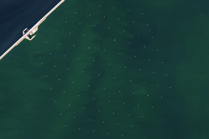
Update on August 3, 2023: This puzzler image shows Windpark Fryslân, the world’s largest freshwater wind farm, located in the Netherlands. Congratulations to Emeric for being the first reader to correctly identify the wind farm and its location. Special mention to Hans for the interesting piece of trivia. Read more about the location in our Image of the Day story.
Every month on Earth Matters, we offer a puzzling satellite image. The July 2023 puzzler is shown above. Your challenge is to use the comments section to tell us where it is, what we are looking at, and why it is interesting.
How to answer. You can use a few words or several paragraphs. You might simply tell us the location, or you can dig deeper and offer details about what satellite and instrument produced the image, what spectral bands were used to create it, or what is compelling about some obscure feature. If you think something is interesting or noteworthy, tell us about it.
The prize. We cannot offer prize money or a trip on the International Space Station, but we can promise you credit and glory. Well, maybe just credit. Within a week after a puzzler image appears on this blog, we will post an annotated and captioned version as our Image of the Day. After we post the answer, we will acknowledge the first person to correctly identify the image at the bottom of this blog post. We also may recognize readers who offer the most interesting tidbits of information. Please include your preferred name or alias with your comment. If you work for or attend an institution that you would like to recognize, please mention that as well.
Recent winners. If you have won the puzzler in the past few months, or if you work in geospatial imaging, please hold your answer for at least a day to give less experienced readers a chance.
Releasing comments. Savvy readers have solved some puzzlers after a few minutes. To give more people a chance, we may wait 24 to 48 hours before posting comments. Good luck!
We’re looking at the Fryslan wind farm just next to Breezanddijk.
In the top right corner we see a short stretch of the 32km dam Afsluitdijk which separates IJsselmeer (the green colored body of water ) from the Waddenzee (Wadden Sea – part of North Sea).
A couple of weeks ago the dam was reopened for a weekend for cyclists and pedestrians, but the renovation works will continue until next year.
My guess is it’s ALMA. Atacama Large Millimeter Array, ALMA has 66 radio telescopes, but I’m hoping maybe they have backups or these remaining are there for other reasons. It’s important because me may have more data on newly formed stars. If not it has to be an array of antennas or telescopes, ect. of some variety
This is obviously a wind farm, with a tidy array of wind turbines in relatively shallow water. The diagonal structure across the top left could be a causeway, or more likely a dike. For a wild guess, I’ll put this in coastal water near the Netherlands.
This array isn’t especially large. We’ll need much more extensive installations of wind power as we transition rapidly off of fossil fuels.
IJsselmeer
GoThrough For smaller boats
Tee
An elevated road in upper left corner crossing a body of water with either an array of solar energy or wind energy collectors to right of road. Unknown location but Persian gulf or Gulf of Mexico?
As a guess, I would say that it is a Wind Turbine farm. There’s too may objects to be satellite dishes. No idea of location. It’s in a shape of a hexagon and from the colour I think it is in the sea.
I’m guessing the objects are in low orbit and are Starlink satellites.
Updating my earlier submission, I was right about a wind farm in the Netherlands, but this is not off-shore.
The photo shows an inland body of water, IJsselmeer, and the Breezanddijk development along the causeway. The development is at 53.012286°N 5.279941°E, with port facilities on each side, and a campground.
It could be part of the Pierre Auger Observatory in Mendoza Provinz, Argentina. There is an array of 1600 detectors which detect ultra high energy cosmic rays.
On the simple side it could a wind farm sitting in the Thames Estuary in England.
Sihwa Lake Tidal Power Station
Windfarm of Texas coast
A fault in the East China Sea near Japan
The Afsluitdijk – barrier to protect the Netherlands in case the sea level rises.
The Location is Breezanddijk in the Netherlands.
The water in the Zuiderhaven is green, the open North sea apears in Blue. Clearly visible is the Wind Farm Fryslan.
Image taken by Landsat or Sentinel-2.
The picture is in The Netherlands. it is on 53.1’14 N and 55.12’28.43 O
It is the Zandbreeddijk. It is calles the Afsluitdijk.
It is important, because you see little dots. Yhese dots are windmills producing power.
Leo den Otter
Dordrecht,
Holland
Location is in the Netherlands, Breezanddijk
There are two power stations, one is REDstack producing electricity from Reverse Electro Dialysis.
The grid of dots south east of it is a “wind park” (the dots are wind turbines)
Sigi Baumgartner
Swakopmund
Namibian
P.S.:thanks for the great sandstorm image you published last week
A field of wind turbines in the sea next to a dam in the Netherlands
The picture show the Afsluitdijk, and in particular the location called ‘Breezanddijk’ where the monument is located in honor of the designer Ir. Lely.
It connects the provinces Noord-Holland an Frieskan. It has a length of 32,5 km.
It was built between 1927 and 1932 and officially opened in 1933.
Starlink from ISS?
Wind farm, Not sure where.
De Holle Poarte …, Sneek – Makkum, Koninkrijk der Nederlanden
It is very nice from above to see big hexagon…
maybe future of energy
This is Fryslan wind farm , 89 turbines in the Ijsselmeer
Afsluitdijk
Breezanddijk, Netherlands
The 20-mile causeway that separates the Netherlands from the sea. Officially opening in 1933. The dam was formed by depositing boulder clay from the bottom of the Zuiderzee along the barrier before adding layers of basalt rock and sand.
It shows a wind farm on the Issjelmeer (Issjel Lake) as well as the town of Breezanddijk, which is part of the structure of the Afsluitdijk (Barrier Dyke) in the Netherlands.
In the picture a small fragment of the “Afsluitdijk” in the Netherlands, separating the IJsselmeer from the North See. The dike was built in 1927-1923. Reconstruction is ongoing at the moment to adjust to the modern norms of safety and to incorporate past and future sea level rise.
The dots in the picture are a wind farm; 89 turbines of 4.3 MW each.
Nice trivia: each turbine has a red flashing light on top to warn planes. These lights flash synchronised, not only for this park but also synchronised with the land-based turbines further to the south-west at Wieringermeer. It is a nice view if you travel from Frisia to North-Holland by car (or bicycle) during the night.
Hi, I guess that the satellite is positioned above a water body with life guard boats kinda positioned in a square with planktons on the surface of the water. I think it is interesting as the lights are so accurately aligned.
Es granja eólica Fryslan ubicada en Paises Bajos.
A floating solar array in the Netherlands. Its unusual as these
Panels track the sun’s rays.
This is the damp of the netherlands Ijsselmeer, an old part of the north sea that was separated through the damp and has no tides anymore. The port seen in the upper left is Breezanddijk and the small dots in hexagonal orden are wind generators.
Breezanddijk, a hamlet located on artificial islet in the middle of the Afsluitdijk dam in Netherlands, separating the North Sea (Waddensee) from Ijssermeer.
This is a picture of the Afsluitdijk in the Netherlands. “The 32-kilometre-long Afsluitdijk, built between 1927 and 1933, is an important part of the Zuiderzee Works and connects the provinces of Friesland and North Holland. It also changed the saltwater Zuiderzee into the freshwater IJsselmeer. The Zuiderzee Works consisted of two parts. In the first stage, the Zuiderzee was dammed, turning it into a freshwater lake. The second part of the plan was the reclamation of new land. This meant that, after the Zuiderzee had been closed off, the entire new province of Flevoland was reclaimed from the waters.” (from Holland.com)
The picture shows the Fryslan wind farm near the Afsluitdijk that created the Ijsselmeer in the Netherlands. The 109 m tall wind turbines form the hexagonal pattern of white dots and produce up to 382.7 MW of power, sufficient to power up to 500,000 households. The wind farm produces approx. 1.2% of the electrical power consumption in the Netherlands. The upper left hand corner shows the community Breezanddijk, which originally housed the workers that built the Afsluitdijk.
The community of Breezanddijk, Netherlands. It is near the midpoint of the Afsluitdijk which separates the IJsselmeer from the North Sea. The array of white dots are wind turbines in the Fryslan wind farm in the IJsselmeer.
This is the Fryslan wind farm, build on the shallow side of the Afsluitdijk. This is the dike that separates the fresh-water IJsselmeer (where the windmills are) from a tidal channel of the salt-water Waddenzee which is obviously darker and deeper. The Waddenzee is an embayment of the North Sea, which is just across some barrier islands about 15 miles away to the north (up in the picture) and west (left).
This wind-power project generates about 380MW — enough to power, maybe, 4% of Dutch households.
An offshore Wind Farm called: Windpark Fryslân, in Netherlands.
Hornsea 2, world’s biggest wind farm, off the coast of the UK?
One of 15,000 wind farms
Parque eólico en España
Offshore wind farm off the East coast.
Fryslan Wind Farm on the IJsselmeer, Netherlands
The image shows the Frysland Wind farm near Breezanddijk in the Ijsselmeer bay in central Netherlands.
The White dots in the center of the image are Windmill also in the left you can see the Afsluitdijk dam that divides the Ijsselmeer artificial bay front the sea.
Looks like a coastal wind farm near a dike. Netherlands?