
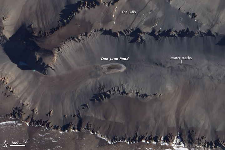
Shortly after we posted our December puzzler, Dan Mahr had responded with the correct answer. “This is definitely a scene of the McMurdo Dry Valleys in Antarctica. Specifically, I think this is Wright Valley, and the body of water at center is Don Juan Pond, one of the most saline lakes in the world. The high salinity prevents the water from freezing despite the temperature being well below the freezing point of normal, non-saline water,” wrote Mahr. About an hour later, Lee Saper chimed in with a link to the Dickson et al study that helped inspire the post. Meanwhile, Edwin Clatworthy was the first of many to weigh in with the correct location on Facebook.
If you read our Image of the Day caption, you know that Don Juan’s water is the saltiest in the world. But where exactly does the water come from in such an arid environment? While scientists suspected deep groundwater bubbling up was the source for decades, the Dickson et al study comes to a different conclusion. By setting up a monitoring station that took thousands of photographs, the scientists showed that salts in the soil suck available moisture from the air through a process called deliquescence.
These water-rich salts then trickle down slopes toward the pond, often mixing with small amounts of melt water from snow and ice. Fresh melt water flows in from the west, while a briny trickle arrives from the east. For a more visual explanation of how this works, check out the two videos from Jay Dickson below. By stringing together all the photographs, you can literally see how Don Juan pond gets its water. The captions accompanying the videos are straight from Dickson’s Antarctic time-lapse research page.
Time-lapse data show water tracks hydrating at the exact moment that a front of moist air passes through Upper Wright Valley. This is confirmation that salts (specifically CaCl2) absorb water out of the atmosphere, generating brines that match the composition of Don Juan Pond, the saltiest body of water in the world.
Two months of 5-minute interval imaging allowed for detailed mapping of inputs into Don Juan Pond. Freshwater is input from the west (right), while previously undocumented seeps of brine provide input from the east (left). These pulses are controlled by diurnal spikes in surface temperature, consistent with a near-surface source. Input from deep groundwater sources was not observed.