

We recently received this question from Jeff, a reader in Colorado:
We’ve been having lots of hazy days in Colorado. I’m sure it’s common over most of the U.S., Alaska, Canada, and Greenland. Most likely, it’s also over Europe.
I saw your images of fires burning in Russia. Could it be that a lot of our haze in the western U.S. and beyond, is due to these fires? I realize there are also many fires burning in the lower 48 states at this moment.
Would you be able to post information concerning the vast amount of smoke and pollutants that are now being created by mankind, and how that is directly affecting the process of climate change.
Jeff’s first question is one that air quality officials ask routinely. Is the pollution over my city from local sources that can be regulated, or does it come from somewhere else? Summer pollution can have many sources, both local and distant.
I sent the question to Gabriele Pfister, researcher at the National Center for Atmospheric Research in Boulder, Colorado. Gabriele has investigated how smoke travels and what impact it has on air quality far from the fires. She replied:
Around the world, ash and thick smoke from wildfires can fill the skies. While the smoke seems to disappear with distance from the fires, polluting gases and small particles that are invisible to the human eye can be carried away by global air currents. Over the past decade, satellite data helped reveal that pollution transport often occurs over hundreds and even thousands of miles, and long-distance transport has received increased attention due to the potential impact on the air quality of continents downwind.
Wildfires release a range of chemical species to the atmosphere, similar to pollutants emitted from human sources. These include the greenhouse gases carbon dioxide and methane, but also other air pollutants such as carbon monoxide, nitrogen oxides, volatile organic compounds, and aerosols. The gaseous pollutants also influence tropospheric ozone formation, a pollutant as well as a potent greenhouse gas.
Research on the transport of pollutants in the troposphere indicates that air pollution is not a local but a global problem. A good example for this is a study by Pfister et al. on the extreme wildfires that happened from June through August 2004 in Alaska and Canada. These fires produced approximately 30 teragrams of carbon monoxide, roughly equal to all the human-generated carbon monoxide for the entire continental U.S. during that same period. Using satellite data and models, researchers estimated that ground-level ozone increased by up to 25 percent in the northern continental United States, and by up to 10 percent in Europe.
So, could Russian fires be causing hazy days in the United States? Let’s take a look at some satellite measurements. This image shows carbon monoxide, one of the constituents of smoke, in July 2011. Carbon monoxide is not visible, but it can combine with other pollutants to contribute to urban haze. It is also a harmful pollutant on its own.
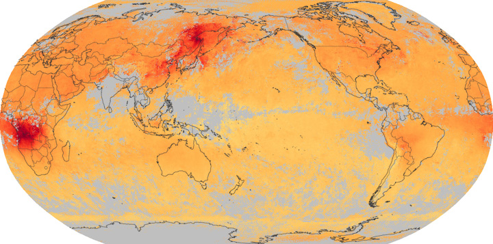
The image was made with data from the MOPITT sensor on the Terra satellite. High concentrations of carbon monoxide are red and lower concentrations are yellow. (Regularly updated images are on the NEO web site.)
The Russian fires burned throughout July, and clearly they produced a lot of carbon monoxide. Carbon monoxide may also be coming from industrial processes in eastern China. Carbon monoxide concentrations are high across the North Pacific and into North America. Some of the gas over North America may be from the Russian fires, but intense fires in Canada probably contributed much more to air quality in the United States.
One of my favorite resources for tracking pollution in the United States is the Smog Blog. They have several posts discussing the Canadian smoke over the United States in July.
Jeff’s second question—how is pollution directly affecting Earth’s climate—is among the most important questions in climate science at the moment. The greenhouse gases released from fires will accelerate global warming. However, most pollutants act like a shade that cool the Earth by reflecting energy back into space. The exceptions are black carbon or soot particles, which absorb energy and make the atmosphere warm up while the surface cools. See Aerosols: Tiny Particles, Big Impact.
On the other hand, pollution has a few indirect impacts on climate. When particles settle on snow or ice, dark-colored pollution causes that surface to absorb energy rather than reflect it. This results in additional warming.
Pollution also affects clouds in a variety of ways, and clouds have a huge impact on global climate. In some cases, pollution causes clouds to be brighter and reflect more energy, causing cooling. In others, pollution can suppress the formation of clouds. Since clouds reflect energy and cool the Earth, the absence of clouds would cause warming. Right now, scientists don’t know exactly how the interaction between clouds and pollution will influence the climate.
We can be pretty sure, however, that global warming will impact pollution. Here’s what Dr. Pfister said:
About half of the world’s air pollution comes from wildfires, and a bad fire year can result in pollution from the fires circling the globe. Global warming is expected to cause earlier snowmelts, hotter temperatures, more frequent droughts, and more frequent and more potent fires. (Actually, this is already occurring.) And these fires release even more pollutants and greenhouse gases into the atmosphere that in turn might result in even hotter and drier weather and more fires.
Great question, thanks for writing Jeff!

At Earth Observatory, we try to bring you views of as many natural events as we can fit into a day. Some days, the satellites don’t have a good view. And other days, we have to leave the office because of an earthquake…
While most of the U.S. East Coast is talking about the quake that set the ground rippling from South Carolina to Montreal, we can’t offer you the maps of ground shaking intensity or tremor magnitude that we usually assemble. That’s because NASA’s Goddard Space Flight Center was shut down this afternoon for building and infrastructure checks, as were many other federal facilities in the Washington, DC, area. We’ll post something once we are back online tomorrow.
Compared to the disastrous earthquakes that have rattled the world in the past year, the quake in Mineral, Virginia, is a baby. But in an area that does not get many noticeable quakes, it rattled millions of people…
Virginia wasn’t the only unusual part of the U.S. shaking today. Colorado saw it’s biggest quake in 40 years.
We were thinking about showing Hurricane Irene, which is beating a menacing path toward the Bahamas, Turks and Caicos, and the eastern U.S. coast. Puerto Rico and the Dominican Republic have already been pounded. But the storm was positioned today in a slot just between the orbital path of the Terra and Aqua satellites (views here and here and here) . The view is likely to be better tomorrow.
For now, we will point you to this view from our friends on the International Space Station (video here). Keep your eyes on our natural hazards section, as I suspect we will see a lot more of that storm this week.
Ever since we posted an image last week of a coccolithophore plankton bloom, I have been trading notes with Peter Eick, an Earth Observatory reader and seismic surveyor working in the Barents Sea. “I look at your site every morning,” he wrote. “I found today kind of neat since I am in your picture and saw the event firsthand.”
Peter spends half to two-thirds of each year traveling the world for work, and he has seen some compelling phenomena along the way. “The scary things are the red blooms (PDF) in the Persian Gulf or the jellyfish packs in the Gulf of Paria. Both just make you want to pray that the ship does not sink.”
Last week, Peter and fellow shipmates noticed an unusual color to the seas around their ship, and the stillness of the water. He shared a few photos from the aft (back) deck of the ship:
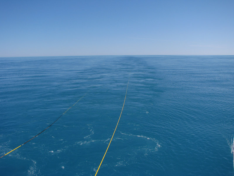
“It was quite a unique color for the water, almost a cyan,” he wrote. “We thought it might have been some sort of algae or sediment event initially, but then the whales came in and really were common in it. They must have been eating the animals that live off the bloom.”
“Normally the arctic is a brilliant deep blue, and very scenic (except when it is rough). It is still rough right now, but the weather is going to lay down in the middle of next week. I will try and get you some more pictures that really show how deep the cyan is. It’s pretty amazing if you are used to the normal, blue-water deep ocean.”
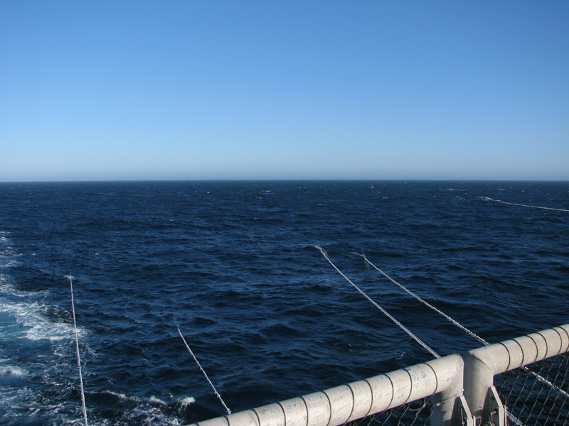
We can see many intriguing things from space, and the science of remote sensing has been developing for at least a half a century. Still, it is always nice to have some “ground truth”…to see images from up close, at the Earth’s surface that confirm what we see from space. Thanks to Peter for sharing.
If you have a timely photo of a phenomenon or landscape that we present on Earth Observatory, drop us a line. We can’t promise to use them, but you never know what you may inspire us to do.
PS – If you want to see more images of the bloom, look here and here…
Post composed by Jesse Allen, Earth Observatory data visualizer
One thing we occasionally hear from readers is “Why don’t you have images of…?” We actually get some really fantastic ideas just that way. For instance, just a few weeks ago, we got a request for satellite imagery of the slide at Medvezhiy Glacier in Tajikistan courtesy of a reader’s letter.
However, sometimes we don’t cover an event because we cannot see it. Take, for instance, the recent tornado in Blagoveshchensk, a city on the Amur River in eastern Russia, near the border with China. The rare tornado was initially reported as a super-powerful EF4 or EF5 strength storm. NASA sensors, such as the Advanced Land Imager (ALI), have been used to observe storm damage from comparable storms: see the April 2011 ALI imagery of Tuscaloosa, Alabama, for example.
It turned out that the initial reports of tornado strength in Blagoveshchensk were probably a bit off, though that wasn’t much consolation to the people in harm’s way. (Tornadoes are extraordinarily rare in all of Russia, and none had that struck Blagoveshchensk in recorded history. ) The tornado was certainly not a minor storm: at least one person was dead and 30 were injured, according to news sources. Damage from the storm was estimated to be worth as much as US$2.9 million. But it was probably not the same kind of super-strong storm as the Tuscaloosa event.
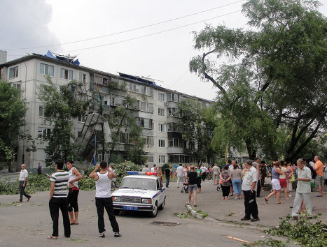
How do we know? In this ground-based photo, you can see damaged trees, roof sections torn off, and the covered balconies ripped off the sides of the apartment building. But this was not the kind of total demolition seen in super-powerful tornadoes like those that struck the U.S. in April 2011. As shown in the image below, the tornado did not leave a wide swath of damage across Blagoveshchensk.
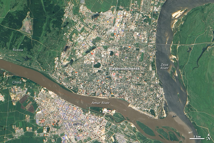
The ALI instrument cannot see anything smaller than 10 meters, so the storm track just doesn’t show up. Sometimes we don’t see things in satellite images because they are just too small to be viewed that way. Some commercial satellites, which have resolutions as tight as 50 centimeters, might show storm damage. But research satellites are not designed to look for features that small.
We had fun with last month’s “Where on Earth” mystery, so we thought we’d throw a new image out for your guessing pleasure.
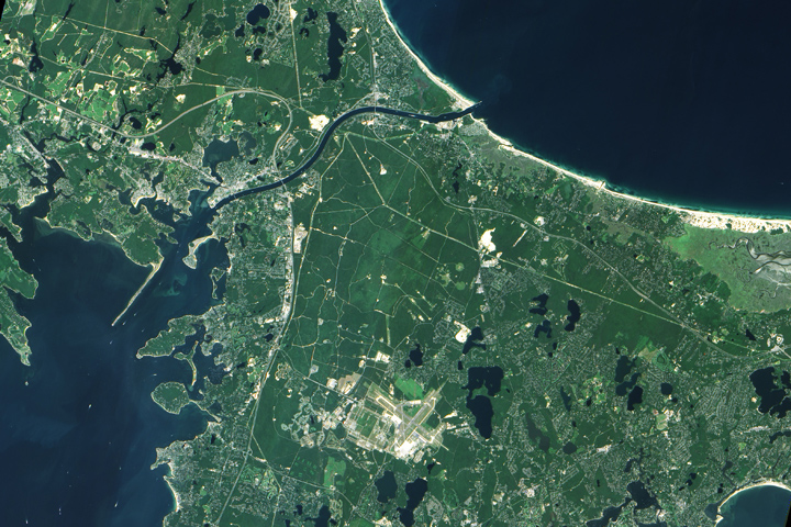
A few hints…
+ German U-boats sank a tug nearby in 1918…
+ The ponds in the image were formed by retreating glaciers…
+ The main waterway in the image is partly man-made…
+ Down the road, a famous stretch of parkland just celebrated its 50th anniversary…
We are a bit short on prizes — and federal laws keep us from offering much beyond our admiration. But after all, success is its own reward.
PS (added at 1:30 p.m.) — Well, clearly that was too easy. So let me make it harder – can you find my house in there? Aha!
ANSWER (added August 23, 2011) = the Cape Cod Canal

On July 29, the Earth Observatory posted an image (above) from the MISR Mystery Image contest. How did you do? Did you guess South Africa? The image is rotated so that north is in the lower right. Visible as a cement-colored grid at this distance, Cape Town sits at the head of the U-shaped bay, called False Bay.
The MISR team revealed the image location and answers to the associated trivia quiz on their web page. More than 470 people from all over the world entered the contest. Congratulations to the winners!
PS – Here is the image flipped around so that north is at the top…
