This astronaut photograph of the Reliant Park area of Houston, Texas, is one of the highest spatial resolution images ever obtained from the International Space Station.
Published Nov 15, 2010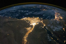
The Nile River and its delta looks like a brilliant, long-stemmed flower in this astronaut photograph of the southeastern Mediterranean Sea at night.
Published Nov 8, 2010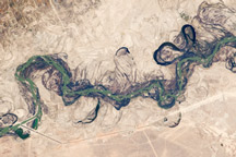
Acquired September 30, 2010, this astronaut photograph shows part of the Syr Darya River Floodplain in Kazakhstan, where the river flows through braided channels.
Published Nov 1, 2010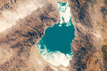
Pyramid Lake, in western Nevada, is a remnant of the ancient and much larger Lake Lahontan that formed during the last Ice Age.
Published Oct 18, 2010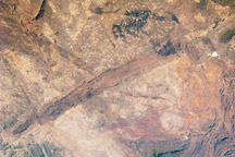
The Great Dyke of Zimbabwe is a layered intrusion of igneous, metal-bearing rock that has been dated to approximately 2.5 billion years in age.
Published Oct 11, 2010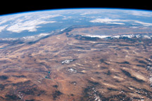
This panoramic view of the southwestern USA and Pacific Ocean was taken by an astronaut looking out at an angle from the International Space Station
Published Oct 4, 2010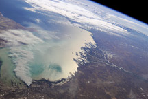
Astronauts on the International Space Station took in this view of the north coast of the Caspian Sea and two river deltas in Kazakhstan and Russia on September 11, 2010.
Published Sep 27, 2010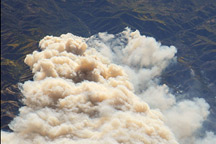
This astronaut photograph shows smoke billowing from the Twitchell Canyon Fire in central Utah on September 21, 2010.
Published Sep 21, 2010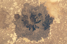
Es Safa is a striking basaltic volcanic field located in Syria, within the larger Harrat Ash Shamah—the largest volcanic field on the Arabian tectonic plate.
Published Sep 20, 2010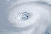
Astronauts aboard the International Space Station took this photograph of the eye of Hurricane Igor on September 14, 2010.
Published Sep 16, 2010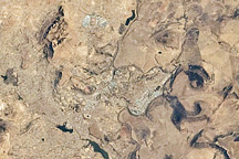
Maseru is the capital city of the Kingdom of Lesotho, and is located along the northwestern border of the country with the Republic of South Africa.
Published Sep 13, 2010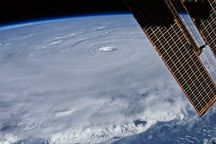
An astronaut on the International Space Station snapped this photograph of Hurricane Earl as a Category 4 storm on August 30, 2010.
Published Sep 2, 2010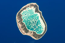
This astronaut photograph shows Mataiva Atoll, the westernmost atoll of the Tuamotu Archipelago.
Published Aug 30, 2010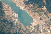
Taken on July 31, 2010, this astronaut photograph shows an industrialized area of Turkey at the eastern edge of the Sea of Marmara.
Published Aug 23, 2010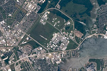
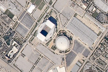
Acquired July 31, 2010, this astronaut photograph features the NASA Lyndon B. Johnson Space Center.
Published Aug 16, 2010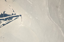
Photograph of a portion the oil slick in the Gulf of Mexico taken by an astronaut aboard the International Space Station on July 23, 2010.
Published Aug 4, 2010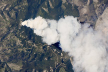
Taken July 25, 2010, this astronaut photograph shows the Dominic Point Fire burning in the Bitterroot National Forest in Montana.
Published Jul 28, 2010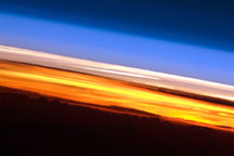
Astronauts aboard the ISS see sixteen sunrises and sunsets per day.
Published Jun 14, 2010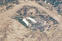
Taken on May 22, 2010, this astronaut photograph shows flooding along the Vistula River near the towns of Gorzyce, Sokolniki, and Trześń.
Published May 28, 2010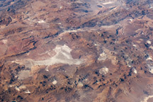
A panoramic view of South America from the Atacama Desert in the Andes to the Atlantic Coast is captured in this astronaut photo from April 26, 2010.
Published May 17, 2010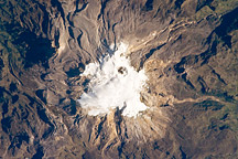
Eruptions at glacier-mantled Nevado del Ruiz Volcano in Colombia have been accompanied by deadly mudflows.
Published May 3, 2010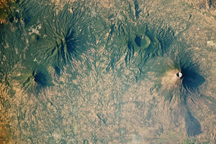
Differences in size and surface features reveal the histories of four adjacent volcanoes.
Published Apr 26, 2010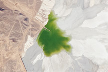
The impoundment area for waste materials associated with the Escondida Copper Mine in Chile is centered in this astronaut photograph from December 9, 2009.
Published Apr 5, 2010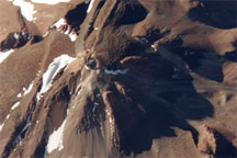
This detailed astronaut photo shows the summit of South America’s Llullaillaco Volcano, the highest historically active volcano in the world.
Published Mar 29, 2010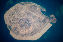
This astronaut photograph illustrates the varying character of surfaces on Sir Bani Yas, an island in the Persian Gulf near the west coast of the United Arab Emirates.
Published Mar 15, 2010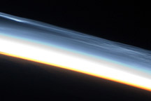
Night-shining clouds high in the atmosphere over the southern polar region appear in shades of blue and orange in this astronaut photo from January 30, 2010.
Published Feb 22, 2010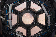
Primarily designed to give astronauts a way to see the outside of the ISS, it also provides stunning panoramic views of Earth and space.
Published Feb 20, 2010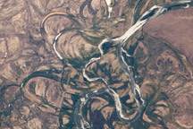
This astronaut photo from January 4, 2010, shows meander scars and oxbow lakes in the floodplain of the Rio Negro in South America.
Published Feb 15, 2010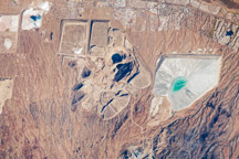
This astronaut photograph illustrates three open-pit copper mines located west-northwest of the town of Green Valley, Arizona.
Published Feb 8, 2010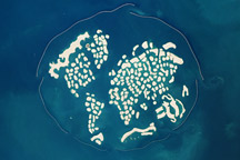
Taken January 13, 2010, this astronaut photograph shows two artificial archipelagos along the Dubai coast: Palm Jumeirah and The World. The image also shows the 800-meter-tall Bhurj Khalifa high rise building.
Published Feb 1, 2010alert message
