

Earth Day (8,192 by 8,192 pixels, 9.1 MB JPEG)
Earth Night (8,192 by 8,192 pixels, 4.2 MB JPEG)
Credit: NASA Earth Observatory images by Robert Simmon, using Suomi NPP VIIRS data from Chris Elvidge (NOAA National Geophysical Data Center). Suomi NPP is the result of a partnership between NASA, NOAA, and the Department of Defense.
I’m giving a talk about the development of the Blue Marble tomorrow at the Information Week Government IT Leadership Forum. In addition to some details of the render, I’ll discuss the history of NASA’s views of the Earth, starting with TIROS-1, continuing through the Apollo Program, interplanetary probes, and the Earth Observing System. If you’re attending and want a copy of the presentation (or are just curious), here it is. If you check the hidden slides you’ll some interesting images I won’t have time to discuss.
Keynote (124 MB)
Powerpoint (124 zip with .ppt file & folder with movies)
PDF (12.5 MB, no movies)
Related Links
The Blue Marble True-color global imagery at 1km Resolution.
My original blog post, Crafting the Blue Marble.
Blue Marble Next Generation.
The Blue Marble Next Generation—A true color Earth dataset including seasonal dynamics from MODIS. (880 kB PDF).
Pictures of Earth by Planetary Spacecraft The Planetary Society.
During every minute of the day, every day, a volcano is erupting somewhere on Earth. Actually, it’s more like a dozen. Or two. Satellites capture much of this activity, and we try to highlight as many eruptions as possible, but for one reason or another (like clouds) some of them fall through the cracks. Here are a handful from the past few weeks:
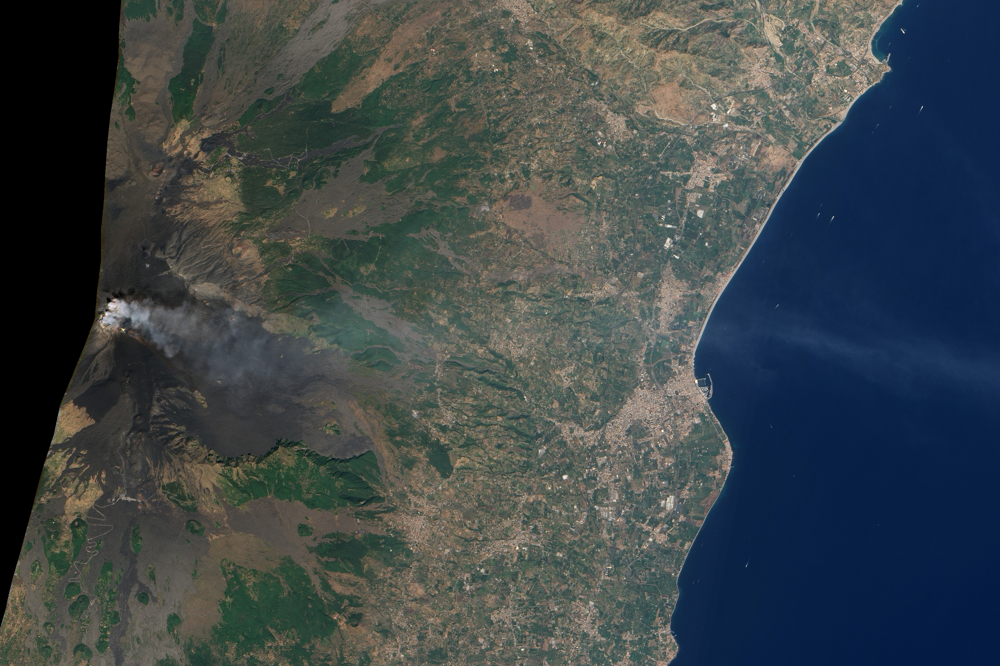
Natural-color satellite image of Mount Etna, Italy; acquired on September 18, 2011, by the Advanced Land Imager (ALI). Credit: NASA Earth Observatory/EO-1 Science Team.
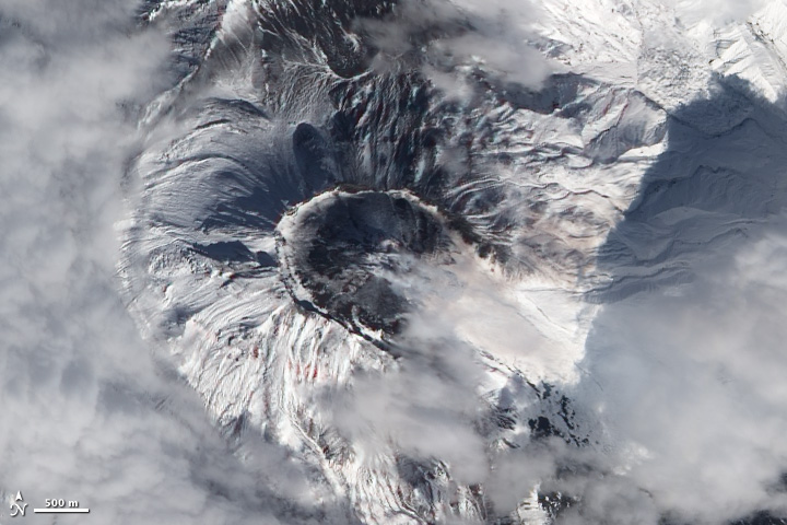
Natural-color satellite image of Bezymianny Volcano, Russia; acquired on September 20, 2011 by the Advanced Land Imager (ALI). Credit: NASA Earth Observatory/EO-1 Science Team.
False-color satellite image of Kizimen Volcano, Russia; acquired on September 21, 2011, by the Advanced Spaceborne Thermal Reflection and Emission Radiometer (ASTER). Credit: NASA Earth Observatory and the NASA/GSFC/METI/ERSDAC/JAROS, and U.S./Japan ASTER Science Team.
Natural-color satellite image of Ambrym Volcano, Vanuatu; acquired on September 23, 2011, by the Advanced Land Imager (ALI). Credit: NASA Earth Observatory/EO-1 Science Team.
Once upon a time Landsat images were expensive (Landsat 7 data was $600 per scene, and the earlier satellites were even pricier) and difficult to find. Now the data—which dates to 1972—is free, and reasonably easy (or at least not painfully difficult) to browse and download from the Global Visualization Viewer, or even the Google Earth Engine (which still has some rough edges).
There are some amazing things buried in the archive, like this natural-color image of an eruption at Rabaul. According to the Global Volcanism Program the activity at the time was “continuous, forceful emissions of thick, light-to-dark gray ash clouds.”
Poke around, and let me know what you find.
The photos were taken about 3 seconds apart, from 11:20 to 11:31 UTC, September 3, 2011. Images from the Gateway to Astronaut Photography of Earth.
Two more images that don’t quite fit on the main site: Nabro Volcano and the Riley Road Fire near Houston.
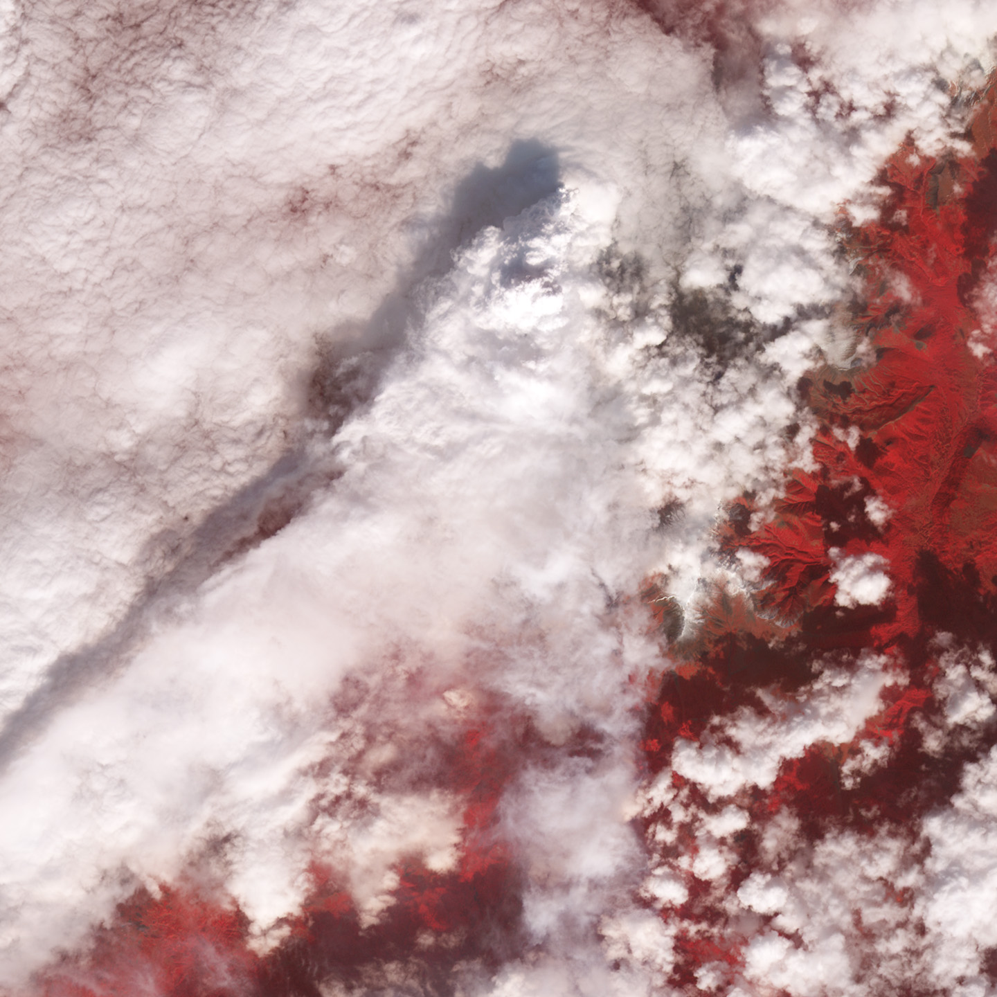
Nabro Volcano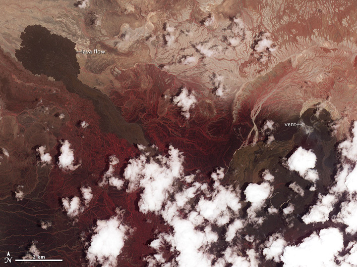 This long-dormant Eritrean volcano began erupting in June, but it’s so remote (at least for western media and scientists) that there’s been no news from the area for months. Unfortunately it’s often been cloudy, so we haven’t gotten any good satellite imagery, either. The best recent imagery is this false-color image (vegetation is red), which shows activity has ceased, although there may be a slight hint of gas emissions near the vent. We’re still trying for better imagery, and will post anything we get in our Volcanoes and Earthquakes section.
Riley Road Fire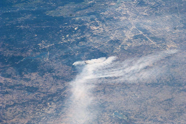 Closer to NASA’s home is this photograph from last week of smoke from the Riley Road Fire, which burned 18,960 acres (7,670 hectares) near Houston, Texas (visible in the upper right corner). It was taken by an astronaut aboard the International Space Station, who could probably see his (the Expedition 28 crew is all male) house at the time.
Credit for the Nabro Volcano image goes to the the NASA/GSFC/METI/ERSDAC/JAROS, and U.S./Japan ASTER Science Team, and credit for the Riley Road Fire to the Image Science and Analysis Laboratory, NASA-Johnson Space Center.
Sometimes I’ll find a surprise in a satellite image. In this case, kilometer-tall letters that spell out “LUECKE” near Austin, TX (Near the Bastrop Fire):
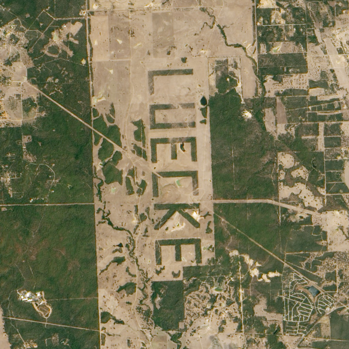
Although this could have just been a curiosity for passing pilots and astronauts, it turns out that Johnson Space Center scientists used the letters to estimate the maximum resolution of cameras aboard the Space Shuttle.
We also made an empirical estimate of spatial resolution for lower contrast vegetation boundaries. By clearing forest so that a pattern would be visible to landing aircraft, a landowner outside Austin, Texas (see also aerial photo in Lisheron 2000), created a target that is also useful for evaluating spatial resolution of astronaut photographs. The forest was selectively cleared in order to spell the landowner’s name ‘LUECKE’ with the remaining trees (figure 10). According to local surveyors who planned the clearing, the plan was to create letters that were 3100 ´ 1700 ft (944.9 ´ 518.2 m). Photographed at a high altitude relative to most Shuttle missions (543 km) with a 250-mm lens, Formula 3 predicts that each pixel would represent an area 28.6 ´ 36.0 m on the ground (table 5). When original film was digitised at 2400 ppi (10.6 mm/pixel), letters correspond to 29.4 ´ 18.8 pixels for a comparable pixel size of 27 – 32 m.
It’s reminiscent of the map of Italy I saw on a hillside near Castellucio, in the Apennines, or even the Nazca Lines. What other examples of landscaping visible from space are out there?
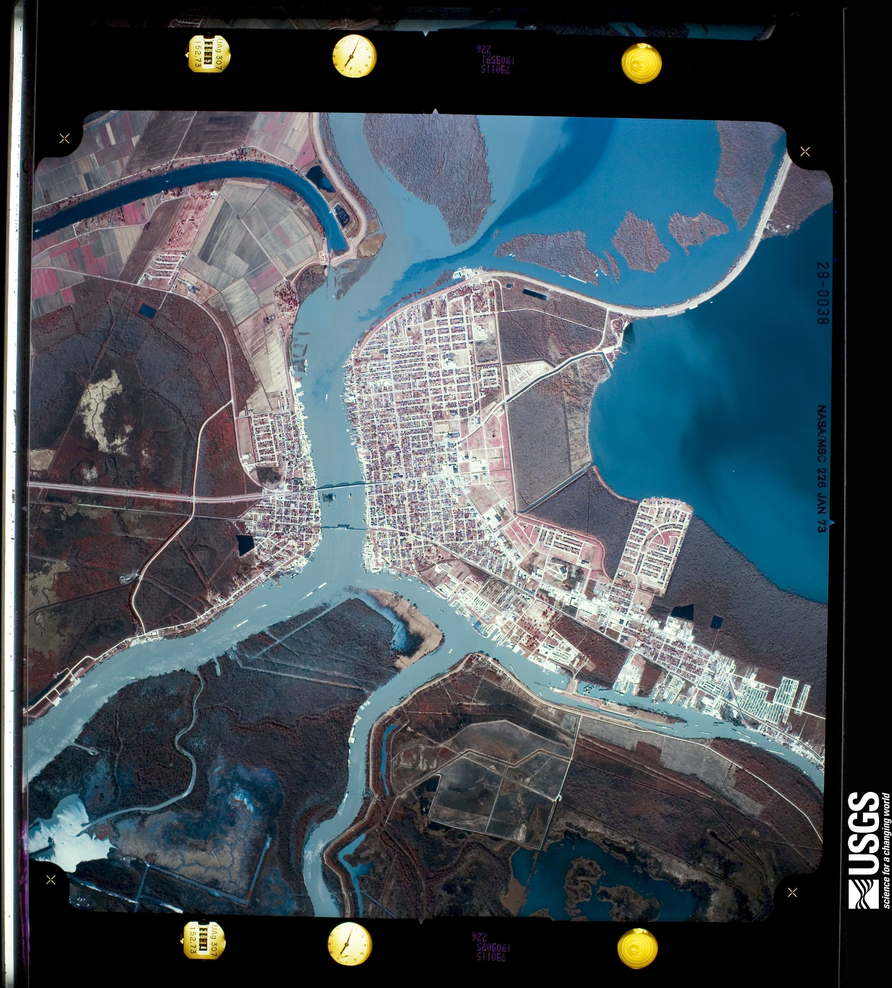
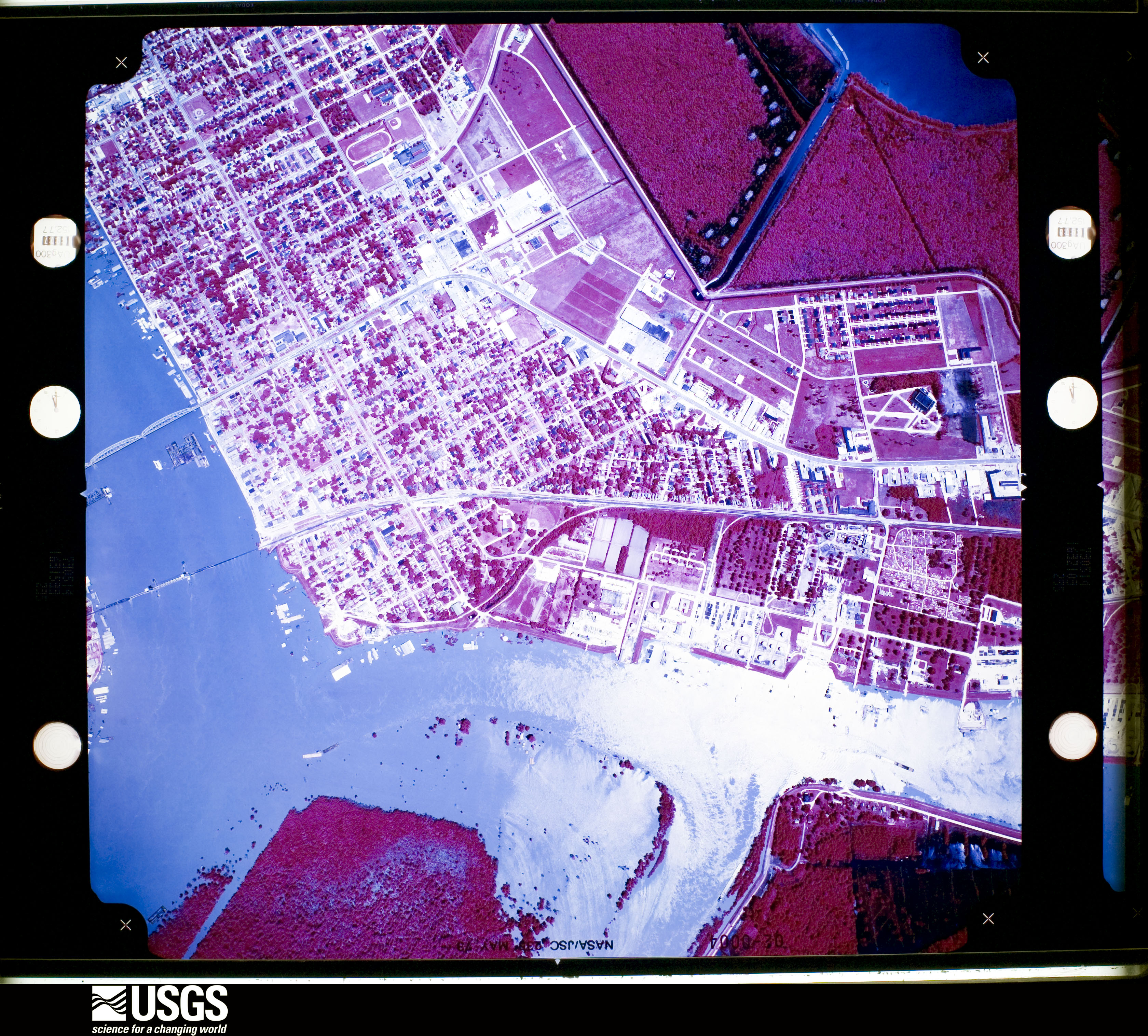
While poking around looking for imagery of the 1973 flooding on the Mississippi, I discovered some fascinating, very high resolution aerial photography. Images of Morgan City—a community near the mouth of the Atchafalaya River that was damaged by flooding in 1973, and will likely be hit by rising water in the next few weeks. Both are false color, but the May image is either a poor scan or the originals have degraded. These photographs, and thousands like them, are available from Earth Explorer, the online USGS archive of satellite data and aerial photography. John Mcphee’s essay “Atchafalaya” from his book The Control of Nature beautifully describes Morgan City and the 1973 flood.
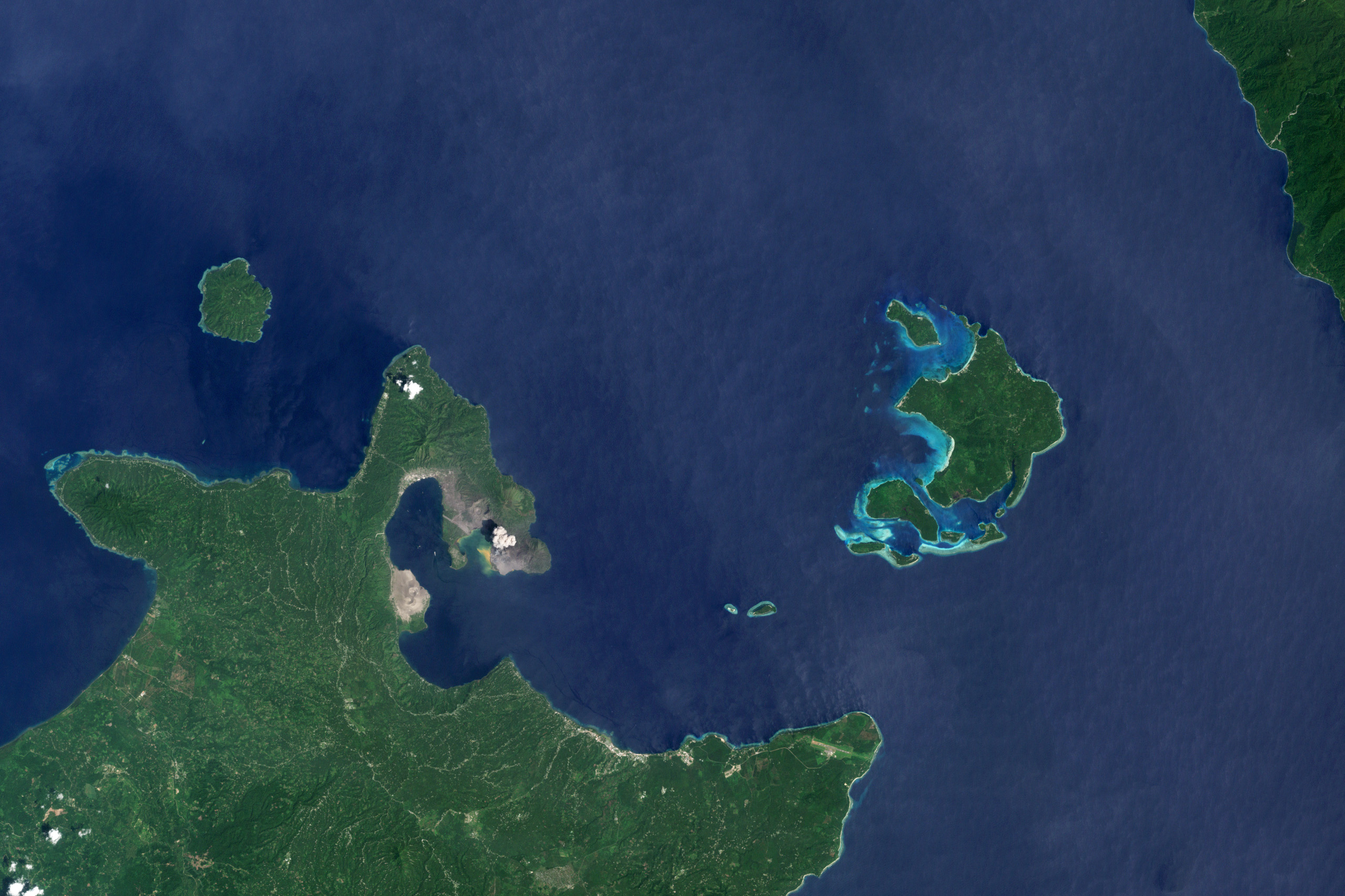
Russia’s Kamchatka Peninsula is perhaps the most volcanically active spot on the planet. Last week’s Global Volcanism Program weekly report (for February 16–22, 2011) listed three Kamchatkan volcanoes currently in eruption—Karymsky, Kizimen, and Shiveluch—and two others—Bezymianny and Klyuchevskaya—were mentioned earlier in February. In one overpass a NASA satellite captured four of these volcanoes in one narrow overpass, only 60 kilometers wide and 300 kilometers long. All of them exhibit plumes. I zoomed in on the most spectacular—Kizimen and Shiveluch—for our Natural Hazards section, but I’d like to share Klyuchevskaya (below) and the entire image—all 9,822 by 20,729 pixels of it (13 MB JPEG).
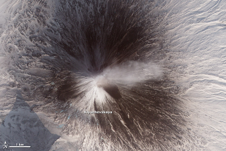
NASA Earth Observatory image by Robert Simmon, using data from the NASA/GSFC/METI/ERSDAC/JAROS, and U.S./Japan ASTER Science Team.
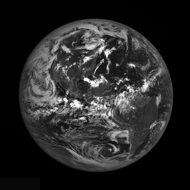
North and South America, August 9, 2010.
By Mark Robinson, LROC Team.
As LRO orbits the Moon every two hours sending down a stream of science data, it is easy to forget how close the Moon is to the Earth. The average distance between the two heavenly bodies is just 384,399 km (238,854 miles). Check your airline frequent flyer totals, perhaps you have already flown the distance to the Moon and back on a single airline!
LROC’s most recent Earth calibration sequence captured a magnificent view of the Americas with only minimal cloud cover. Contrast the current image with the NAC view taken last June, which revealed much of central Asia.
The Moon is a spectacular sight in the nighttime sky. Now imagine the Earth from the Moon, four times larger, a delicate blue, and it does not rise nor set. To astronauts, the Earth is a constant companion, at least on the nearside. Of course, on the farside you can never see the Earth.
The overarching goal of the LRO mission is to obtain the data needed to enable engineers and scientists to design the hardware and instruments to pick up lunar exploration where it was paused in December of 1972, after Apollo 17. LRO has now collected these data, so we are ready to move along the path of returning to the Moon! Will designs for lunar habitats include Earth windows? Certainly a human factor to consider! Are there any adverse psychological effects for future lunar explorers on the farside with no Earth overhead? What do you think? For now, we are happy to occasionally snap an image of the Earth as the NAC collects routine calibration data.
View the full-size image (4400 by 440 pixels) on the LROC gallery.
