The Landsat Data Continuity Mission is now Landsat 8, and that means images are now public (woohoo!). NASA handed control of the satellite to the USGS yesterday (May 30, 2013), and calibrated imagery is available through the Earth Explorer. Unfortunately, the Earth Explorer interface is a bit of a pain, so I’ve put together a guide to make it easier.
First, go to the Earth Explorer site: earthexplorer.usgs.gov
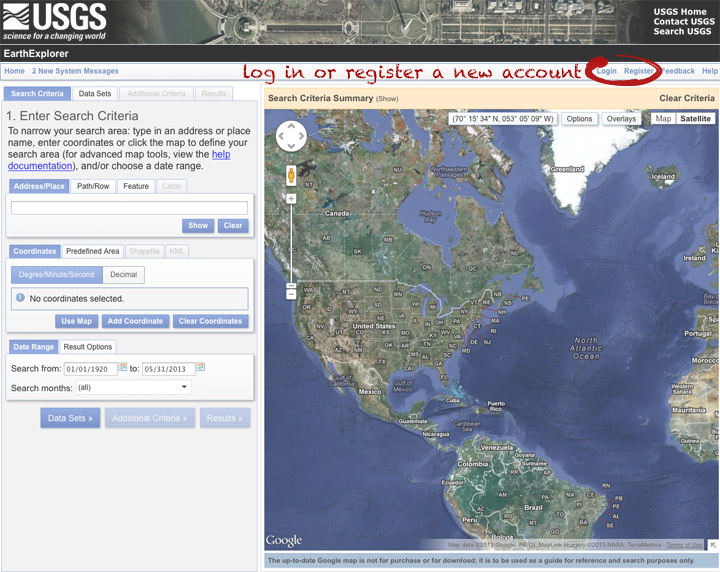
You can search, but not order data, without logging in—so register if you don’t have an account (don’t worry, it’s instant and free), or log in if you do.
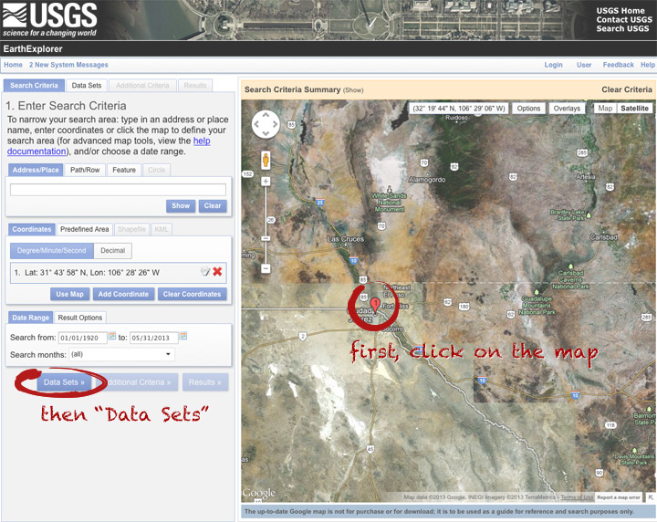
The simplest way to select a location is to simply pick a single point on the map. You can define a box or even a polygon, but that makes it more likely you’ll get images with only partial coverage. Navigate to the location you’re interested in, and click to enter the coordinates. You can choose a data range, but right now there are only 3 or 4 scenes for a given spot, so skip it and just click “Data Sets”.
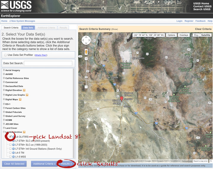
On the data sets page, you can search everything from Aerial Imagery to Vegetation Monitoring. Click the “+” symbol next to Landsat Archive, then the first check box that appears: “L8 OLI/TIRS” (which stands for Landsat 8 Operational Land Imager/Thermal Infrared Sensor (creative, no?)). Click “Results” to start a search.
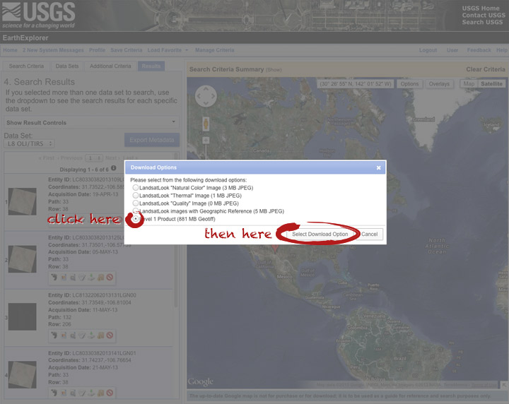
After a short wait, you’ll get a list of available images. The thumbnails aren’t big enough to show much, so click on one to see a slightly larger image. Close that window, and click the download icon: a green arrow pointing down towards a hard drive …
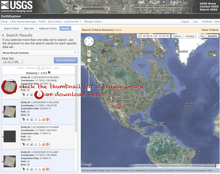
… which doesn’t actually download the data, just provides a list of download options. “LandsatLook” are full-resolution JPEGs, and are a quick way to check image quality (I’d prefer full-resolution browse images without a separate download, but I digress). The Level 1 Product is terrain-corrected, geolocated, calibrated data—a bundle of 16 bit, single-channel GeoTIFFs. Select the “Level 1 Product” radio button, then click “Select Download Option”.
Done! Oh, wait. Not done. You need to click one more button: “Download”.
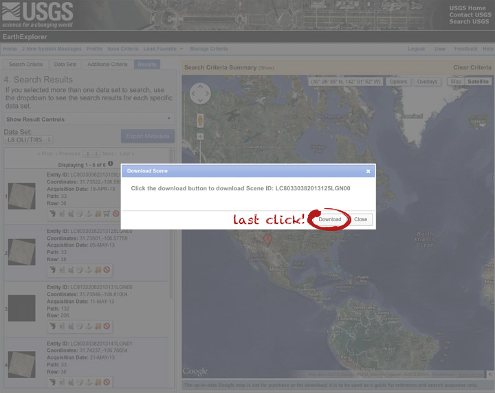
Now you’re done. The data should arrive in your browser’s designated download folder.
Drop a note in the comments section if I’ve skipped a step, or if you have any other questions. Next week I’ll explain what to do with the data once you’ve got it.

This photo of Skylab was taken by the astronauts of Skylab-2 as they left the space station and departed for Earth on June 22, 1973. More photos from all three Skylab missions are archived on NASA’s Gateway to Astronaut Photography of Earth.
To look through the rest of the Skylab collection, select Find Photos > Search > Mission-Roll-Frame from the menu in the upper-left hand corner of the Gateway to Astronaut Photography of Earth home page. Under Missions pick one or more of SL2, SL3, and SL4, then delete the “E” in the Roll field. Finally, hit Run Query at the bottom of the page. On the Database Search Results page, enable the Show thumbnails if they are available checkbox. Click the number in the Frame column to view a screen-sized image. High-res images are downloadable from each Display Record, just click the View link for the image size you want.
Enjoy.
Japan’s MTSAT-2 (also known as Himawari-7) collected these images of today’s annular solar eclipse from geostationary orbit. The satellite (similar to the United State’s GOES satellites), observed the moon’s shadow as it passed over Australia & the Pacific Ocean. The image sequence begins at 21:32 UTC, with an additional image each hour until 02:32 UTC. The eclipse itself lasted from 22:33 UTC until 02:20 UTC.
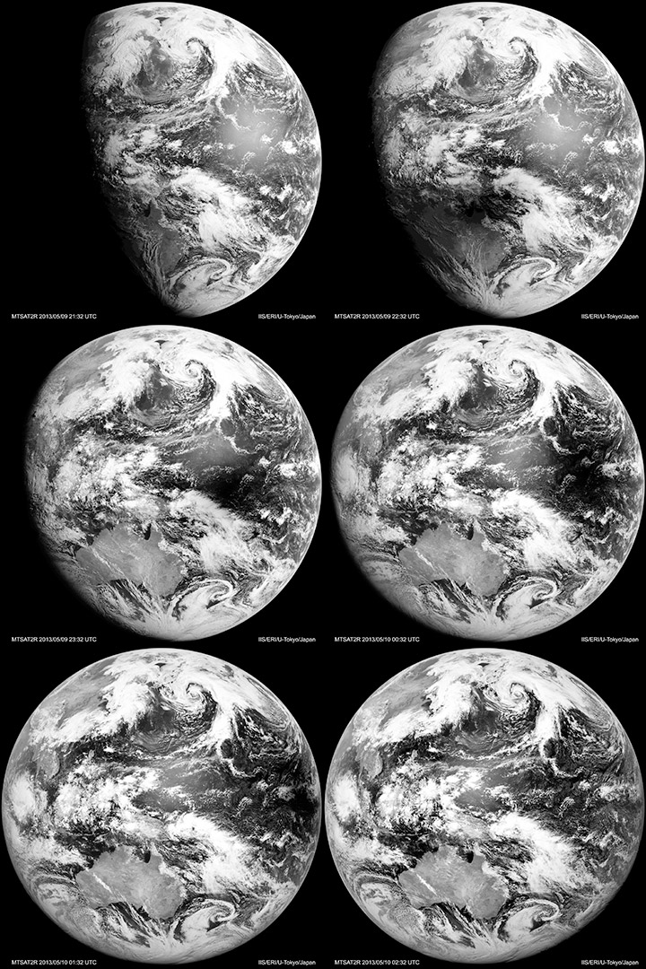
Visible-light & infrared MTSAT images dating back to October 2006 are available from the Earthquake Research Institute & Institute of Industrial Science, University of Tokyo.
