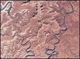
This park in Utah encompasses some of the most remote and rugged terrain in the continental United States.
Published Jan 3, 2008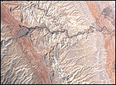
Sixty million years of erosion have exposed folded layers of rock.
Published Oct 3, 2007
No battles were fought here, but it was still one of the most important landmarks of the American Revolution.
Published May 27, 2007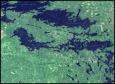
Established in 1975, the park saw fur traders nearly two centuries earlier, and it supported human inhabitants thousands of years before that. Today, almost a third of the park is water, and travel through the park is usually by boat.
Published Oct 1, 2006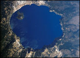
Crater Lake is formed from the caldera of Mount Mazama. Part of the Cascades volcanic chain, Mount Mazama sits between the Three Sisters volcanoes to the north and Mount Shasta to the south. The catastrophic eruption of Mount Mazama that occurred approximately 7,700 years ago destroyed the volcano while simultaneously forming the basin for Crater Lake. Eruptive activity continued in the region for perhaps a few hundred years after the major eruption. Evidence of this activity lingers in volcanic rocks, lava flows, and domes beneath the lake surface; the small cone of Wizard Island is the only visible portion of these younger rocks. Although considered a dormant volcano, Crater Lake is part of the United States Geological Survey Cascades Volcano Observatory seismic monitoring network.
Published Sep 18, 2006
President Kennedy designated this area a National Recreation Area in 1963 as a demonstration site to explore how an area with limited value for agricultural or timber harvesting and no major industrial activity could be transformed into an economically productive recreation area.
Published Jul 16, 2006
The park sits at the eastern edge of the Paunsaugant Plateau, and the ridgeline offers stunning views across southern Utah.
Published Jun 25, 2006
Northern Arizona is best known for the Grand Canyon. Less widely known are the hundreds of geologically young volcanoes scattered across the southern portion of the Colorado Plateau at the eastern foothills of the San Francisco Peaks.
Published May 23, 2006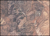
The landscape was formed as wind, water, and earthquakes carved away a 23-million-year-old volcano.
Published May 14, 2006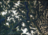
Over 300 glaciers, about one-third of the glaciers in the Lower 48 states, lie within the park boundaries.
Published May 7, 2006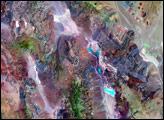
At 86 meters (282 feet) below sea level, Death Valley, California, is one of the hottest, driest places on the planet.
Published Apr 16, 2006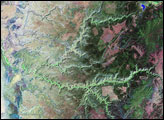
Canyon de Chelly National Monument was created in 1931 to protect the cultural heritage of the canyon lands of Arizona.
Published Apr 2, 2006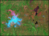
Although nearly a century has passed since its last eruption, signs of volcanic activity are still visible in this false-color image.
Published Jan 29, 2006
The landscape is a recently formed set of basaltic lava flows that creates a foreboding landscape of sharp obsidian, cinder and spatter cones, twisted rivers of solidified rock, pit craters, and a network of caves from lava tubes.
Published Oct 16, 2005
Black Canyon of the Gunnison National Park is a small park that encompasses the steep-walled canyons of the Gunnison River, which drains snowmelt from the Rocky Mountains in western Colorado.
Published Oct 2, 2005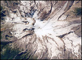
A clear summer day over Washington state provided the International Space Station crew the chance to observe Mt. Rainier—a volcano that overlooks the Seattle metropolitan area and the 2.5 million people who live there. In addition to its presence on the Seattle skyline, Mt. Rainier also looms large among volcanoes in the United States.
Published Sep 26, 2005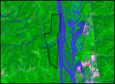
The park was created in October 1949 to protect a small area along the banks of the Mississippi River where Native Americans built earthen mounds for millennia.
Published Sep 11, 2005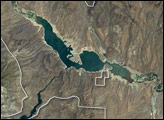
The most striking feature is Roosevelt Lake, an artificial lake created by the construction of Roosevelt Dam across the Salt River. The National Monument is surrounded by the Tonto National Forest, which includes low plains, desert scrubland, and alpine pine forests.
Published Sep 4, 2005
The park encompasses about 37,000 hectares of the Sonora Desert.
Published Jul 24, 2005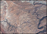
Situated in Utah, the park is home to 2,000 arches and windows in rock, as well as rock spires and pinnacles.
Published May 8, 2005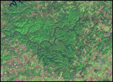
Archaeological evidence indicates that American Indians living in the area began exploring the cave system in the late Archaic period, between 5,000 and 3,000 years ago. European settlers first found the caves in 1798.
Published May 1, 2005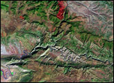
The paleontologist Eric Douglass made the first discoveries here in 1909, and President Woodrow Wilson proclaimed it a national monument in 1915.
Published Apr 3, 2005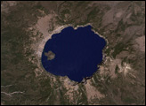
It one of the oldest parks in the United States, created in 1902 by President Theodore Roosevelt.
Published Jan 23, 2005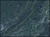
The park runs roughly 40 miles along the Delaware River and the Appalachian Mountains, which are immediately adjacent to the river.
Published Jan 9, 2005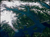
The first recorded charting of the area was done in 1794 by George Vancouver, in which he showed the bay being a small indentation in the Icy Strait with a gigantic glacier stretching off to the horizon.
Published Dec 7, 2003
The park stretches through the Blue Ridge Mountains in Virginia.
Published Sep 8, 2003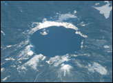
Crater Lake, a volcanic caldera in South Central Oregon’s Cascade Mountains, boasts breathtaking scenery, created about 7,700 years ago with the volcanic eruption and subsequent collapse of the summit of Mt. Mazama.
Published Jan 26, 2003