
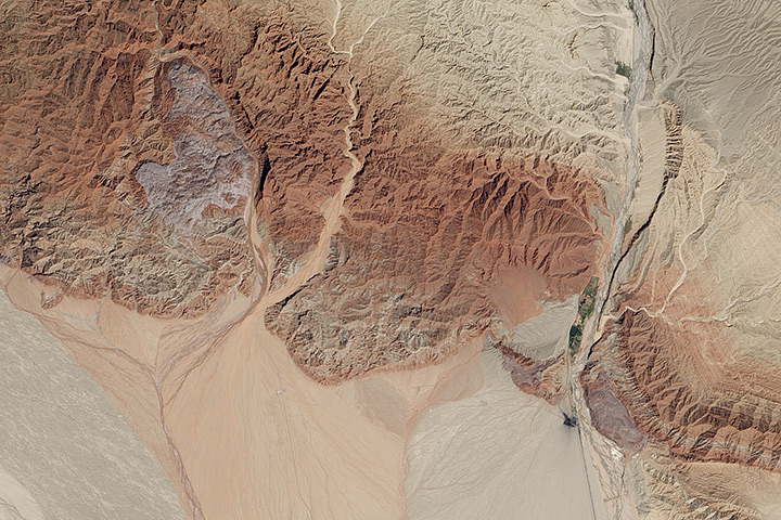
Every month on Earth Matters, we offer a puzzling satellite image. The October 2015 puzzler is above. Your challenge is to use the comments section to tell us what part of the world we are looking at, when the image was acquired, what the image shows, and why the scene is interesting.
How to answer. Your answer can be a few words or several paragraphs. (Try to keep it shorter than 200 words). You might simply tell us what part of the world an image shows. Or you can dig deeper and explain what satellite and instrument produced the image, what spectral bands were used to create it, or what is compelling about some obscure speck in the far corner of an image. If you think something is interesting or noteworthy, tell us about it.
The prize. We can’t offer prize money, but, we can promise you credit and glory (well, maybe just credit). Roughly one week after a puzzler image appears on this blog, we will post an annotated and captioned version as our Image of the Day. In the credits, we’ll acknowledge the person who was first to correctly ID the image. We’ll also recognize people who offer the most interesting tidbits of information about the geological, meteorological, or human processes that have played a role in molding the landscape. Please include your preferred name or alias with your comment. If you work for or attend an institution that you want us to recognize, please mention that as well.
Recent winners. If you’ve won the puzzler in the last few months or work in geospatial imaging, please sit on your hands for at least a day to give others a chance to play.
Releasing Comments. Savvy readers have solved some of our puzzlers after only a few minutes or hours. To give more people a chance to play, we may wait between 24-48 hours before posting the answers we receive in the comment thread.
Good luck!
The aftermath of flash flooding in the Mojave Desert near Highway 58 North of Los Angeles California last week. The erosion & flow field resembles a high volume water incident. Cheers!
well, That sounds a very deffo’ answer to me so wont bother with my answer!
I think it’s the edge of the salt flats in Death Valley and the surrounding mountains that run North to South on either side of the valley. Little vegetation, harsh eroded terrain, steep topography, valleys / gulches flowing in direction of valley to supply sediment.
the Sahara desert
If it is USA- I would venture to guess Death Valley- it’s interesting because it is arid but is subjected to heavy rains that sculpt the landscape and deposit the overlapping debris flows/alluvial fans- you can also see the horizontally bedded bedrock in the lower right hand side- this should be a clue to use to my advantage…just can’t do much better than I’ve done so far…fun
It appears to be the Xinjiang region of China which has similar color bands, known for showing very visible fault lines in the mountains. If I had to guess a specific area within Xinjiang it would be the Tarim Basin just south of the Tian Shan mountains. This would make the desert area at the bottom of the picture (which I assume to be south) to be the Taklamakan Desert. Of Historical note, if it is indeed the Tarim Basin, the northern route of the Silk Road passed through this area.
Arabian Desert in Saudi Arabia. I would say close to Taif.
I have not studied it, guessing Africa at first glance! I’m watching the
NASA program on BTV
It looks like an area at high altitude and not near the poles where glaciers are about to melt completely. A small community is shown where crops are being grown. This community has very little time left before it cannot sustain itself from the land due to the reduction of water from drawn out glacial melt. It’s probably in the Himalayas or nearby, but could be anywhere in a similar distance from the poles.
It looks like the “7 colored mountain” in Purmamarca, Argentina.
I visited the area in 2011 and it was impressive.
The puzzling satellite image is that of an area in China near, what looks to me as if it could be the mouth of, the Tuomo Erfeng Shenqi Grand Canyon, coordinates 41.560431 80.756791
Good night
Is Argentina. The image show us The glaciers are shrinking. This phenomenon will cause climate change and the oceans.
Thank’s
Very new to this, so I can’t say when the image was taken. I am picking the dry season of this area. Where? Somewhere predominantly desert. Shows a dry river system bordered by a mountain range broken by a dry river (on the left) and a ‘live’ watercourse on the right (marked by the fact that it is not running with water but there are two oases). What first caught my eye was what appears to be a large land slip on the left, but if the image is true-colour, then I suspect it may be an old slip because it seems to have evidence of weathering appearing. Secondly, I notice a sharp black, broken line running down the right hand side, with two darker areas at the lower end of the line. I am guessing there has been an earthquake and this line has opened up, with the dark areas possibly being water rising to the surface.
Wondering if this is the Aral Sea. The largest saline lake was ruined by intervention of humans – siphoning off and re-routing water. The terrain seems similar and if I were to guess what the area looked like without that lake, this would be it. Was in the former USSR, in Uzbekistan in 1989. Wish I’d taken the time to get to see the Aral Sea. Never would have expected it to be almost completely gone within the next 20 years.
sahara desert
The Grand Canyon
ARIAL SEA
Looks like the Gobi Desert to me with a manmade Chinese military installation due to the color and height variation plus desert.
Without the man-made looking area in the center, I would have guessed somewhere on Mars (or less likely Pluto) as Mars has some similar topography. and perhaps that is one of the rover landing sites if its Mars.
I also wondered if it might be Egypt with an old temple, but after checking that, the topography is quite different so that is impossible.
Hmm.. let’s see.
Semi-arid climate, as deduced by virtually absent vegetation and antecedent valleys.. which seem to nurture a downstream pretty well developed drainage system. But no true fans, they’re more alluvial aprons, so very low gradient built by very fine sediment, discharged by episodic flooding in a low-relief region out of map in the direction of top right corner.
Also, the pinkish region in the center left of the image could be an outcropping salt dome…
My guess is: lowermost Himalayan foothills, in western India.. or the south-eastern border of the Beluchistan ridge, in Pakistan.
Found it.
Roughly 41.6 N, 80.7 E, approximately 10-15 km south of Bozidunxiang, Wensu, Aksu, Xinjiang Province, China.
Map link: https://www.google.com/maps/place/41%C2%B036'00.0%22N+80%C2%B042'00.0%22E/@41.6111229,80.8030558,11z/data=!3m1!1e3
Atacama Chile.
desierto de Atacama Chile
Dead Sea? The White Spots could be salt. I don’ t know what the Green Spot is. I will look aroud the Earth and come back to you. Could it be Salt?
So it is definitely not in North America. It doesn’t match too many other places, but most likely Iraq or Syria. A lot of desolation out there. The tilting of these mountains hints at fault-blocking, similar to Death Valley and the Great Basin Desert. My initial guess is that of the Northern Atlas Mountains, in Morocco or Algeria. I do agree that the purple is a possible salt dome, and the sandstones and siltstone deposits around it could coincide with such. The lighter brown and heavily ravined formations are old alluvial aprons that have been uplifted by the opening of the valley (similar formations can be found in the Panamint Mountains of Death Valley) and they erode easily, forming many canyons. The verdant development inside the main canyon is due to the fact that the mountains block the flow of groundwater, which pools and nears the surface.
Groom Lake (Area 51)
To me it looks like the foot of the Andean Mountains in Peru, partly showing a valley with groundwater oder or/and river water Irrigation.
Maybe goes even back to Moche culture times?
Arid with little vegetation. Alluvial fans with braided streams issuing from highland area in northern part of image. Prob. visible spectrum. More substantial valley cutting through on RHS with road and two vegetation? areas in defile, and one near NE corner of image, possibly dammed. Scarp on east of image degrades north-westwards. ?Intrusive lighter rock outcrop in NW probably not economic as no evidence of exploitation. Track due westwards from possible industrial site at mouth of major valley in east to two small settlements on alluvial fans. Industrial because of smearing of ?pollution south of dark area due to northerly winds funnelled through valley moving particles southwards into dry areas. No convincing evidence of a major E-W fault scarp although it may be masked by later alluvial deposits. However there is a small oblique fault running NW-SE on scarp on east side of major river valley.
the lower part is higher elevation showing a braided river with high energy…this picture could be many thing but my answer is a slope probably
This place is from Xinjiang, China (towards north east of Aksu area). This area has mostly been in news for disputes related to coal mines. In NE corner of the image, a black spot with some shade effect is seen. It is probably a coal mine. Two prominent alluvial fans (difference in color is also visible) are mixing and getting deposited from Tien Shan mountain belt. I am sorry but I cannot tell you when this image is taken.
I am a geologist in Oil and Natural Gas Coperation Limited, India. I appreciate if my company is acknowledged.
looks like China in or around the Gobi desert. The feature on the right is what makes it unique. We have alluvial fans on the left and then an oasis formed in that feature.
I think it is the area north-east of Sharm-el-Sheikh…
Interresting features? Maybe a faultline? An oasis?
london
My guess is Jordan, maybe Wadi Rum where The Martian was filmed.