
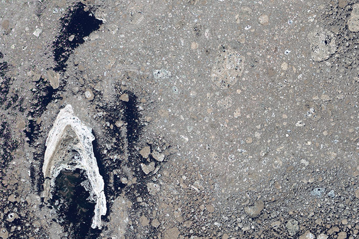
Every month we offer a puzzling satellite image here on Earth Matters. The April 2014 puzzler is above. Your challenge is to use the comments section to tell us what the image shows, what part of the world we are looking at, when the image was acquired, and why the scene is interesting.
How to answer. Your answer can be a few words or several paragraphs. (Try to keep it shorter than 200 words). You might simply tell us what part of the world an image shows. Or you can dig deeper and explain what satellite and instrument produced the image, what spectral bands were used to create it, or what is compelling about some obscure speck in the far corner of an image. If you think something is interesting or noteworthy, tell us about it.
The prize. We can’t offer prize money, but, we can promise you credit and glory (well, maybe just credit). Roughly one week after a puzzler image appears on this blog, we will post an annotated and captioned version as our Image of the Day. In the credits, we’ll acknowledge the person who was first to correctly ID the image. We’ll also recognize people who offer the most interesting tidbits of information about the geological, meteorological, or human processes that have played a role in molding the landscape. Please include your preferred name or alias with your comment. If you work for or attend an institution that you want us to recognize, please mention that as well.
Recent winners. If you’ve won the puzzler in the last few months or work in geospatial imaging, please sit on your hands for at least a few days to give others a chance to play.
Releasing Comments. Savvy readers have solved many of our puzzlers after only a few minutes or hours. To give more people a chance to play, we may wait between 24-48 hours before posting the answers we receive in the comment thread.
Looks like Karaginsky Island almost surrounded by fresh, white new ice, with quite a bit of volcanic dust covered ice elsewhere.
This looks like granite to me..
Mt St Helen’s
May of 1980 something
Erupting
Trash in the Pacific Ocean?
This is an Arctic ice after volcano eruption.
it’s a dune field, near Mawrth Vallis, on Mars. Spotted by the Mars Orbiter on December 30th 2013. parts of it have been identified as being the likely location for ancient water flows. 🙂
Oyster shell on the sea floor
definitely looks like an oyster shell. that was my official guess. or a shot of a planet’s terrain.
It’s what’s left over from the unfortunate Enterprise Cadet that wore the red uniform.
The dead Aral Sea located in Kazakhstan-Uzbekistan.Rapid evaporation is the result of environmental pollution,toxic chemicals from industrial projects.The plains covered with salt and toxic chemicals. Winds pick up the salty dust blow it onto fields as far as 200 miles away.People nearby suffer from cancer, lung disease, digestive disorders, antibiotic resistant tuberculosis, liver, eye, and kidney disorders.The Ko-Aral dam, built in 2005 with the aid of a World Bank loan,saved the North-part of the Aral Sea,water levels are rising,but South Aral Sea could disappear by 2020.
My nearest guess is a cross section of a meteor that was cut in half to view it’s interior.
This is the azov sea or the aral sea. Salt deposits left by the retreatingn water
I lean toward Fernando’s response! It looks like an evaporating lake somewhere, maybe the western USA?
My best guess is that it is a satellite image of dirty glacial debris on a body of water. Relatively fresh sea ice that hasn’t melted or been swept away forms a white crescent around a chain of small islands in the lower left of the image. Underwater shoals can be seen around the islands that are surrounded by clear water.
not sure where but looks like the ground that was beneath a glacier , and one that has recently receded so probably Antarctica or Greenland , nice image
Either sea ice or possibly Northern Siberia.
This looks like the debris or the area around one of the volcanos that erupted in Tolbatchik, Kamchatka Peninsula, Russia.
It’s a pic of the recent landslide in the Dariali Valley of Georgia (the country.)
I would guess this is the rocky terrain near the volcanos in Tolbatchik, Kamchatka Peninsula in Eastern Russia. (with ice and geysers and all).
The ocean floor.
On first sight it looks like agglomerate/volcanic ash in thin section – but no scale is provided & as we are informed that it is a satellite image – my first guess is clearly wrong!!
So I’m puzzled – & look forward to seeing the answer.
I’ve been staring at this for the last hour and im going to say it a photo from the rapid ice melt in the Northwest Passage in the Summer of 2012
My guess is somewhere in the McMurdo Dry Valleys of Antarctica, taken recently and related to the recent news about the decline of Antarctic ice sheets.
It looks like stones in Serbia… maybe mountain Ravna Gora in the circle- but it shows the structure of the Earth here (stones, minerals, etc). Guess blue is for clouds-different types.
Looks like a terminal moraine from a retreating glacier someplace, with a bit of left over ice left in that hollow there. In Greenland perhaps?
Receding glacier in Iceland after volcanic eruption in 2010
I see a glacier wash out but I do like the previous comments concerning volcanic eruption and ice melt.
This is last piece of a glacier melting on a mountain.
Detail of the Oso landslide in Washington
I see a volcanic formation. It may be a volcanic tuff with rounded clasts of other volcanic rocks
Guessing volcanic river in iceland?
this is not a satellite image!!
It is not a picture taken by a sattelite as I see small stones in the image.it is on earth as the image consist of coal(black part).I.m not sure about the white part I think it is frozen water(glacier)…
Looks like Web. A spiders hole
Looks like plastic bag in a long dead Albatross (bones removed) at Midway Atoll !
lake urmiah
lake is drying every year
Sopa de plástico en el océano pacífico, contaminación causada po el ser humano.
a tough one…one clue given is that it’s a satellite image, however It does indeed look like a close up of a volcanic rock…no scale makes it even tougher. my guess ….it is dirty pack ice, probably near the terminal end of a glacier entering the sea. I think the black areas of the photo are open water. some of what I think are the ice floes appear to be reagglomerated, and rounded by tidal action.