“PACE is a mission that will use the unique vantage point of space to study some of the smallest things that can have the biggest impact.” — Karen St. Germain, director of NASA’s Earth Science Division
The skies above us are teeming with tiny particles of dust, sea salt, smoke, and human-made pollutants. The seas, oceans, and lakes around us are teeming with microscopic, plant-like organisms. In both cases, individual bits of these tiny living and inanimate particles are too small for your eye to see. But when billions to trillions of them aggregate in one place, we can see them from space. And these little things make a vast difference for life on Earth.
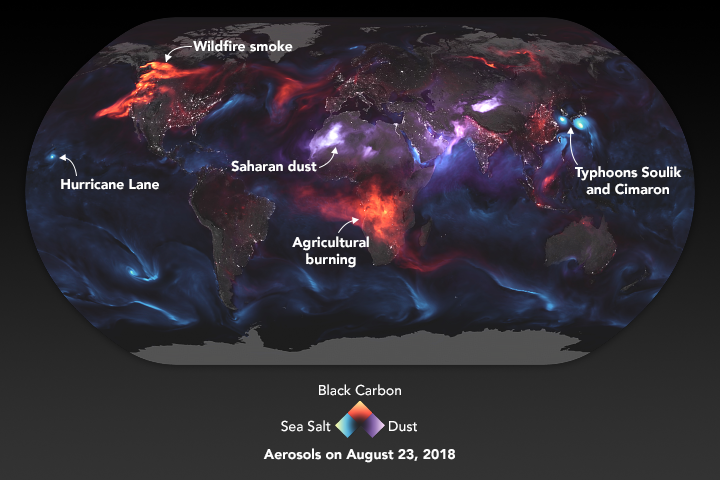
The particles in the air are known to atmospheric scientists as aerosols. Though the spray cans you might use for paint or hairspray do contain aerosols, the ones PACE will study are the flecks of carbon that rise from wildfires and smokestacks; the fine, dusty minerals that get lofted from deserts into the sky by strong winds; the nitrates and sulfates spewed by cars, trucks, and ships in their exhaust; and the salty spray from crashing waves and strong winds blowing over the ocean.
Why study them? Because those particles influence air quality, sometimes making it unhealthy to breathe, especially if you have asthma or heart and lung conditions. Pollution and smoke don’t observe borders – we all share Earth’s air — so it’s important to know something about the sources and types of particles floating around us. On the positive side, the bits of mineral dust or smoky aerosols can sometimes fertilize the ocean, providing nutrients for phytoplankton to bloom.
Aerosols also affect weather and climate. Tiny particles in the air reflect sunlight, and how much they reflect affects how much the land and ocean surfaces heat up. Aerosols also “seed” the formation of clouds: they provide surfaces on which water droplets form (condensation nucleii) as they aggregate into clouds. One of the great unknowns in our models of climate change is what role will aerosols will play in changing rainfall and snowfall patterns and in the heating or cooling of our atmosphere.
Though NASA has been studying aerosols from space for decades — observing where they are and the abundance of them — PACE and its SPEXone and HARP2 polarimeters will change the game. The instruments will tell us the shape and size of aerosols, helping us answer questions about where they come from and how they might influence other parts of the Earth system.
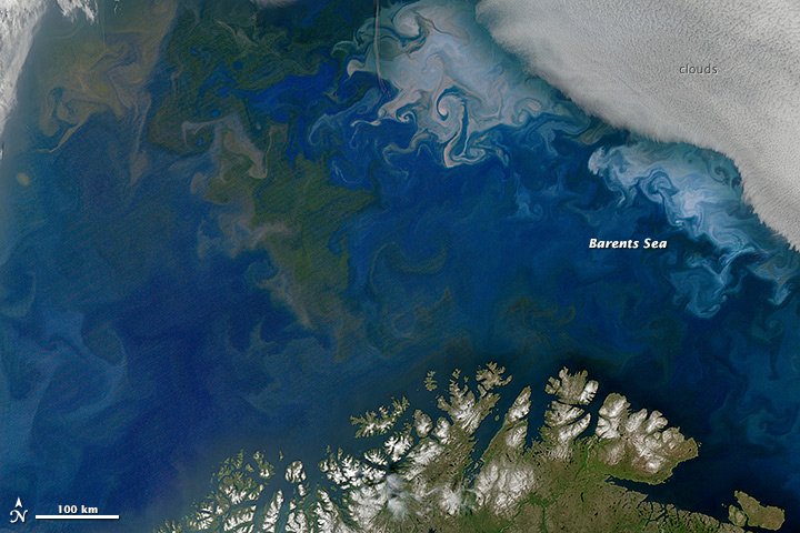
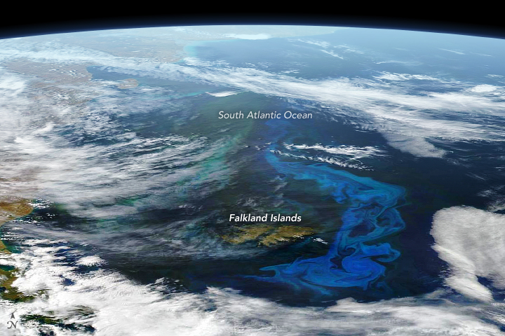
The other little things that PACE will examine have names like diatoms, coccolithophores, cyanobacteria, algae, and dinoflagellates. To borrow and mangle a quote from one of my favorite movie characters — Annie Savoy in Bull Durham — if you have three phytoplankton, they can’t do much. But if you have 300 billion of them, they can build a cathedral. Well, maybe not a cathedral, but they can develop into vast blooms that have a profound impact on life on this ocean planet.
Phytoplankton grow constantly on Earth and just about anywhere there are open, sunlit patches of water. When conditions are right, the growth of these microscopic cells can blossom to scales that are visible from orbit for days to weeks.
Phytoplankton are to the ocean what grasses and ground cover are to land: primary producers, a basic food source for other life, and the main carbon recycler for the marine environment. They are floating, plant-like organisms that soak up sunshine, sponge up nutrients, and create their own food (energy).
Why do we need to study these tiny organisms with PACE? While humans don’t really consume phytoplankton for food, the little floaters are fuel for the zooplankton, fish, and shellfish that we do eat. We also need to care about phytoplankton because they can influence water quality and human health. Some species of phytoplankton produce toxins that are dangerous to humans and animals; others can grow in such abundance that they crowd out other species or deplete the water of necessary oxygen.
Speaking of oxygen, phytoplankton produce a lot of it. Somewhere between 20 and 50 percent of the oxygen on Earth — some in our air, a lot in the ocean — is made by phytoplankton as they use photosynthesis to turn sunlight, carbon dioxide, and nutrients into sugars. In the process, they also draw carbon dioxide out of the atmosphere and, in time, sink it to the bottom of the ocean.
Better understanding the phytoplankton in the ocean will help us better understand the fisheries that feed us and our economy, and it can ultimately help us work toward cleaner waterways.
NASA and its research partners have been studying phytoplankton from space for decades, but mostly with just a few wavelengths of light. I am looking forward to the colors, textures, and details we will see with PACE’s OCI hyperspectral imager. As the PACE science team likes to say: we have been coloring the ocean with a box of 8 crayons, and now we are about to get a box with 128 shades of color. The leap in detail will allow scientists to better spot where phytoplankton are, but also figure out who (what species) they are.
And when PACE data are combined with observations from our recently launched SWOT mission — which studies the shape and movement of the surface of the ocean — it will be like going from the Earth-observing equivalent of the Hubble Space Telescope to the new James Webb Space Telescope.
Learn more about phytoplankton with these resources:
PACE Phytoplankton Exploration
The Insanely Important World of Phytoplankton
NASA Wants to Identify Phytoplankton Species from Space: Here’s Why.
As the Seasons Change, Will the Plankton?
Phytoplankton May Be Abundant Under Antarctic Sea Ice
Learn more about aerosols with these resources:
Just Another Day on Aerosol Earth
New NASA Satellite to Unravel Mysteries About Clouds, Aerosols
Global Transport of Smoke from Australian Bushfires
A few paths in life are short and direct; more of them are long and winding.
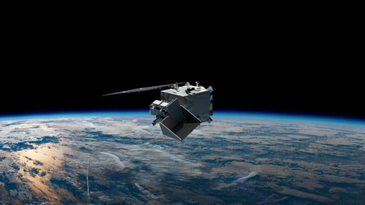
This week, a SpaceX Falcon 9 rocket will launch from Cape Canaveral Space Force Station carrying the PACE satellite, short for Plankton, Aerosol, Cloud ocean Ecosystem. Once in orbit 676 kilometers (420 miles) above our planet, the newest addition to NASA’s fleet of Earth-observers will look at the oceans and land surfaces in more than 100 wavelengths of light from the infrared through the visible spectrum and into the ultraviolet. It will also examine tiny particles in the air by looking at how light is reflected and scattered (using a method like looking through polarized sunglasses).
The combination of measurements from the new satellite will give scientists and citizens a finely detailed look at life near the ocean surface, the composition and abundance of aerosols (such as dust, wildfire smoke, pollution, and sea salt) in the atmosphere, and how both influence and are affected by climate change.
For NASA and the ocean science community, the PACE launch will be the culmination of 9 or 46 years of work, depending on when you start counting. For me, it will be the culmination of something that started in 1950.
“There is a greater than 50 percent chance I will burst into tears at the launch,” said Jeremy Werdell, a satellite oceanographer at NASA’s Goddard Space Flight Center since 1999 and project scientist for PACE since 2015. “We are standing on the shoulders of previous missions and the people who led them. And it has been a long and remarkable journey.”
NASA’s first attempt at measuring ocean color dates back to the Coastal Zone Color Scanner (CZCS) instrument, which flew on the Nimbus 7 satellite from 1978-1986. In 1997, the agency launched the Sea-viewing Wide Field-of-view Sensor on the OrbView-2 satellite. SeaWiFS collected ocean data until 2010 and fundamentally changed our understanding of phytoplankton—microscopic, floating, plant-like organisms that are the grass of the sea. That sensor is an ancestor of the new Ocean Color Instrument (OCI) on PACE.
Other instruments and teams have observed the colors of the ocean. The Moderate Resolution Imaging Spectroradiometer (MODIS) instruments on NASA’s Terra and Aqua satellites have been flying since 2000 and 2002, complementing and extending the record started by SeaWiFS. More recently, the Visible Infrared Imaging Radiometer Suite (VIIRS) instruments on the Suomi-NPP, NOAA-20, and NOAA-21 satellites have provided a broad view of ocean color. And several other instruments — like the Hyperspectral Imager for the Coastal Ocean (which flew on the space station), HawkEye (on the SeaHawk CubeSat), and the Ocean Radiometer for Carbon Assessment (which was flown on NASA research planes) — helped researchers test new ways to look at the sea.
For atmospheric scientists, the path to PACE also traces back across decades. In the late 1970s, the Advanced Very High Resolution Radiometer (AVHRR) provided some of the first looks at aerosol optical depth, a measure of how much dust and particles were floating in our skies. Later scientists began measuring such particles daily and around the world with the Multi-angle Imaging SpectroRadiometer and MODIS instruments on Terra. The OMI instrument on the Aura satellite, and its successor OMPS on Suomi-NPP, provided other unique views of aerosols. A HARP instrument flew on a CubeSat from 2019-2022 and provided a direct test of the technology that now flies on PACE as HARP2.
The origin of PACE itself sort of started around 2007. NASA and other federal agencies asked the U.S. National Research Council to study and suggest new tools and measurements for studying Earth from space. Their report (known as a “decadal survey“) recommended a mission that ultimately led to the A(erosol) and C(loud) components of the PACE mission. The inspiration for new ocean color sensors then arose from a NASA climate initiative proposed in 2010.
By 2012, NASA scientists and engineers were starting to sketch out rough ideas for PACE, and the wider science community dug into the details in 2014. By 2015, NASA Goddard started hiring for a new mission—including Jeremy Werdell—and by 2016, the agency had announced the formal development of a PACE mission.
Between that moment in 2016—known as Key Decision Point A—and this week’s launch there have been thousands of hours of work by hundreds of people…including many months working through a global pandemic…and the methodical, thoughtful testing of every idea, every design, and every part.
For me, the road to the PACE launch has also been long.
I have spent 21 years of my life working for NASA, and yet this will be my first launch. I feel blessed to spend my days working with incredibly talented, visionary, and smart people. This launch feels like the culmination of a lifetime geeking out on Earth and space science. Several threads of my life will all tie together this week.
In 1950, a 7th grader in Newark, New Jersey, won an essay contest by writing about a trip to the Moon. My father was fascinated by science fiction—he still is—and by journalism. He followed America’s developing space program with interest and, in 1969, his youngest son was born two weeks after the Apollo 11 Moon landing. Though no one can remember clearly, I like to say my parents named me for Michael Collins, who quietly orbited the Moon for 21 hours while Neil Armstrong and Buzz Aldrin made the headlines below. (My mother often reminded me that she went through a similar 20+ painstaking hours of labor waiting for me to show up.)
On my first job as a magazine writer, I wrote in 1992 about the Mission to Planet Earth—first an international conference, then an early name for what became NASA’s Earth Observing System. I visited NASA’s Jet Propulsion Laboratory in 1994 to research my graduate thesis and by 1997 I had joined NASA Goddard, where I stayed for five years writing about space weather and space physics.
But then I traded one institution of exploration for another, leaving to write about ocean science for Woods Hole Oceanographic Institution (WHOI). It was during those years on Cape Cod that I learned a boatload about phytoplankton and harmful algae. I spent 11 days at sea in 2005 on the research vessel Oceanus, helping scientists gather water samples to track a pesky, toxic phytoplankton called Alexandrium fundyense. After decades visiting the ocean, I was living by it and learning about it daily.
I rejoined NASA in 2008 and eventually joined Earth Observatory. Circumstances and generous colleagues allowed me to keep living by the sea, and so I brought my love of the ocean into my reporting. I also passed that love of the ocean and space to my children: Two have become marine biologists who study plankton, and one is an aerospace engineer working on satellites.
After so many years of my life intersecting with NASA and the sea, it just feels right that my first rocket launch should be a satellite that will bring us new eyes on Planet Ocean.
As previously stated, it is Cool like in Cool, CA.
Our first science meeting took place midway between T0 (McClellan Air Force Base) and T1 (Cool), so I couldn’t get a better chance to drive to the site that marks our downwind sampling location (T1, that is).
Off Rt. 80, you’ve got to follow the bends of 49 and down the gorge past Auburn, a real pretty town draped around the turns of historic Rt. 40. Then you drive up for another 4 miles past the Cool quarry.

Amidst this rural, very rural area, lies Northside Elementary school. Classes have been over for a week now, yet the backyard still hosts activity spurred by eternal kids with grey hair.
[youtube EX5qIuVhGWs 468]
This very repetitive bird emanates sound waves and the wind and
temperature in the atmosphere above are derived from their influence
on the speed of sound.
In trailers parked as control stations for ground instrumentation they are monitoring every spike in incoming particulates. Everything is very peaceful…trees, Sun, and even digital birds chirping.


Rushing back to the meeting, I found a room plenty with people anxious to display their first week of data. It is very important in the beginning of a campaign to make sure we establish a consistent baseline among all the different instruments.
Big discussions have already been engaged as to what pertains to local events as opposed to consistent transport patterns, but some points confirm the expectations. On a daily basis, a wide variety of small particles including black carbon get transported until they’re detected miles downwind from the sources, growing in size and getting coated with sulfates and other organics. More mysteries are hidden behind the unexpected amount of ultrafine particles, less than 10 nanometers in size (1 nanometer is a billionth of a meter). We’re not sure where they come from but they’re all around the urban areas.
Matteo
There’s nothing special about Sacramento’s urban emissions per se, other than being very typical emissions from a city. So why was the campaign designed to take place here? The thing is that this region has a very well defined circulation pattern, which makes the plume transport very regular.
Southwesterly winds mix two airflows in the afternoon. The first is a persistent flow originating in the San Francisco Bay area. The second is more local and due to air being heated up in the Sierras, which draws the cooler air from the valley. Unless — there is always an unless — the flow gets disrupted by synoptic (read: large scale) storms born in the Pacific. This is apparently what we have been observing in the first days of the campaign, doomed by an unusual amount of mid-level clouds. NASA’s instruments usually fly at around 8-9 km, and these clouds partly spoil our ability to observe aerosols beneath.

In any case, under normal conditions the resulting upslope flow transports the Sacramento’s plume towards the mountains, where anthropogenic aerosols interact with the biogenic sources from the forested areas, which are loaded with terpenes produced by the photosynthetic activity of vegetation. Recent research has shown that these biogenic sources could give an extra kick to the production of secondary organic aerosols of anthropogenic origin. “Secondary” here designates a zoo of different compounds generated by the interactions of “primary” substances with background conditions, leading to a myriad of chemical and physical transformations. An example? Humidity can coat aerosols of a thin film of water, drastically changing their properties.

The overall goal of the mission is to follow the evolution of the plume, sampling the formation of secondary organics and the anthropogenic/biogenic mixing ratio. Of great avail is the Cool “T1” site downwind from the sources here in Sacramento, packed with instrumentation on the ground managed by the Department of Energy. It’s Cool, like in Cool, CA. This nearly uninhabited site will be regularly overflown by the airplanes involved in the campaign so that data from the different platforms can be compared and validated. You can’t have ground sites everywhere, so that’s why the DOE G-1 airplane samples the area in between, trying to fill the gap and find out what happens in between. Plus there is us – the NASA group. We observe the same aerosols from high above, so we provide scene context. Our instruments are prototypes of those that fly on satellites in space, which are so very important because they give continuous global coverage via the “remote sensing” technique, or “the art of collecting data form a distance”. Very politically correct.
I have to thank Jerome Fast, who has extensive experience as chief meteorologist in campaigns like CARES, for his punctual forecast in the daily briefings and the explanations that prompted this post.
-Matteo
There’s always a lot of people thanking each other in a campaign, but today the crew, the pilots, and whoever up there is responsible for good weather deserves all my kudos. I normally don’t get to sit on the airplane, as our instrument works as a Swiss clock and we prefer to save fuel to pull longer flight legs. Today the circumstances were atypical and I got to board, curiously on the day of the one-year anniversary form my previous flight, during the RACORO campaign in Oklahoma.

Touristic companies would have a hard time to match the quality of this Tour of California (and I didn’t have to pay for it). I have to share these pictures, although their quality doesn’t speak enough of the true beauty of the sight. In my partial defense, I must say that the small B200 is extremely crammed and taking a good shot requires leaning over the pilots, which is not something you want to do too often (all other windows are partially darkened).

The route led us South of Sacramento along the San Joaquin valley, majestically shouldered by the Sierras still loaded with late spring snow.

Fresno marked our big right turn toward the coast, right about when we spotted a small fire in the San Benito region.

The flight plan required overpassing some ground stations at NASA Ames and in Monterey, so we were absolutely forced to come back along the Big Sur. Absolutely. It truly is a glorious coastline with surf clearly visible even from a 9km altitude. Cloud banks were innocuously looming from the ocean, a single tongue of fog daring to come further right there where it should be.

The final stretch was over the valleys of Napa and Sonoma, and shortly before touchdown over the only cloud bank the plane had to overfly.
I finally want to mention that yesterday was also “media” day. Here and here is what came out of it. By the way, if you happen to watch the videos, you should note that even if Rahul investigates scientific principles, that doesn’t make him a “principle investigator” as the banner reports. He’s the “principal investigator”. Don’t mean to brag too much about it, it’s just a matter of principle. Since we’re at it, measuring the composition of particles requires a “spectrometer” rather than an “aspectrometer”. Well, in a way we’re measuring the aspect of particles.
-Matteo

