
The high-tide line has been moving landward for some time at Kennedy Space Center on Florida’s east coast. Located within the Merritt Island National Wildlife Refuge and adjacent to Cape Canaveral Air Force Station, NASA’s most famous center covers more than 66 square miles (170 square kilometers) and holds about 20 percent of the agency’s constructed assets. Most of it is built on coastal marshland about 5 to 10 feet above sea level.

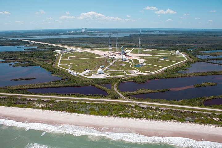
Launch Pad 39B at Kennedy Space Center has been the site of dozens of Apollo era and space shuttle launches. Future SLS and Orion spacecraft will lift off from this site. (NASA)
Conservative climate models project that the seas off Kennedy will rise 5 to 8 inches by the 2050s, and 9 to 15 inches by the 2080s. If ice sheets in Greenland and Antarctica continue to melt as quickly as current measurements indicate, those numbers could become 21 to 24 inches by the 2050s and 43 to 49 inches by the 2080s.
“We consider sea-level rise and climate change to be urgent,” said Nancy Bray, spaceport integration and services director for Kennedy.
Even as the space center was founded in 1961, management and scientists were aware that seas were rising and could someday pose a threat. But in that era, the challenge was to get to the Moon as soon as possible. There was an established Air Force station nearby with access to orbits that could not be obtained from anywhere else in the United States. The choice was easy, and it was right for the time.
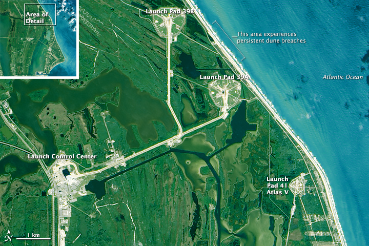
But time has not been kind to this stretch of sand. Based on historical records and aerial photos, the beach in front of Kennedy has thinned and moved inland by as much as 200 feet (60 meters). The losses have been most acute and persistent along a stretch near the center’s two most prized launch pads. Complex 39A was recently leased for 20 years to Space X, which intends to use it for its Falcon heavy lift rocket. NASA’s new Space Launch System and Orion spacecraft are slotted for Complex 39B within the next decade. The Atlantic Ocean stands less than a quarter mile from both.

Crashing waves and sandy shoreline are not far from the launchpads at Kennedy Space Center. That distance is decreasing each year. (NASA Earth Observatory image by Joshua Stevens, using Landsat data from the U.S. Geological Survey)
In 2004, three hurricanes crossed the Florida peninsula. And while none made a direct hit on Cape Canaveral, they collectively caused $100 million in damage to the space center. Then a nor’easter in 2007 sat offshore for two weeks and battered the beach; Tropical Storm Fay then raked the beach again in 2008.
In response to the persistent storm damage, Kennedy facilities managers contracted to build a 15-foot-high, 725-foot-long dune as a proof of concept for a managed retreat. Center scientists and engineers also worked with the U.S. Geological Survey to map the shape of the beach (topography) with laser ranging and detection (LiDAR). Then they enlisted coastal geologists John Jaeger and Pete Adams of the University of Florida to figure out why sand dunes near launch Complexes 39A and B were so persistently being washed away.
For five years, Jaeger, Adams, and graduate students pulled GPS mapping gear up and down 6 miles of beach at least once a month—more often in the wake of storms. The goal was to build a three-dimensional model of the area. They found that the beaches were retreating due to the shape of the seafloor just offshore, where gaps between the sandbars channel wave energy toward certain areas. But they also found sand piling up (accreting) in other areas, mostly near Launch Complex 41. The beach is migrating south, even if NASA’s infrastructure is not.
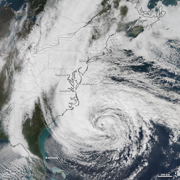
In 2012, Hurricane Sandy offered a glimpse of the new normal along the Atlantic coast. The storm passed 200 miles offshore from Kennedy, but it moved so slowly that the heavy surf scoured the beach for three or four high-tide cycles. By the time the skies cleared, the dunes along a 2-mile (3-kilometer) stretch near Complexes 39A and B had retreated as much as 65 feet (20 meters). Nearly 650 feet (200 meters) of railroad track in the vicinity of 39A were undermined by the storm surge. The high-tide line moved closer to a service road, under which lay some of the center’s natural gas, communications, liquefied rocket fuel, and water lines. That road sits just 4 feet (1.2 meters) above sea level.

Hurricane Sandy had wind, wave, or rainfall impacts on five NASA centers along the U.S. East Coast. (NASA Earth Observatory image by Jesse Allen, using Suomi NPP VIIRS data provided by NOAA CLASS)
“We were surprised that a passing storm could have that much effect. Neither Sandy nor any other recent storm made a direct hit on Kennedy, and yet there has been a lot of damage to the dunes,” said Adams. “The hurricanes get a lot of attention, but it’s the winter nor’easters that take a steady jab at these beaches.”
In the aftermath of Sandy, Kennedy Space Center shored up the beach again. Some of the railroad track was removed, and coastal engineers piled up 90,000 cubic yards of sand to create a 1.2-mile secondary dune. Roughly 180,000 plugs of native dune grasses and other vegetation were planted to hold the sand in place. So far, the dune has performed as designed, providing protection against storm and wave inundation and sea level rise for critical launch infrastructure.
In the longer run, Bray and colleagues at Kennedy are working on what they call a managed retreat. They are building up the shore defenses, while also earmarking land farther inland for additional launch infrastructure should the demand materialize.
“Kennedy Space Center may have decades before waves are lapping at the launch pads,” Jaeger said. “Still, when you put expensive, immovable infrastructure right along the coast, something’s eventually got to give.”