March 25, 2011
This past Tuesday (3/22), MABEL had her first successful flight of 2011!
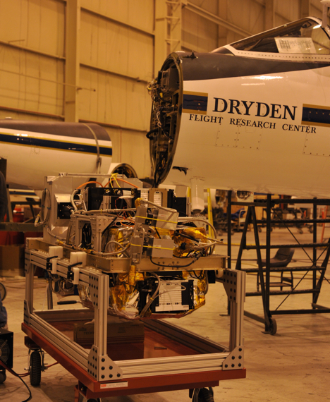
After just a day of hooking MABEL up to the aircraft and checking out her systems (image below), we flew the instrument on what we consider to be a ‘shakedown’ mission. We flew a route local to the Dryden Flight Research Center that is also used by Operation IceBridge. It allows us to ensure that MABEL, and a secondary instrument onboard the aircraft, are operating smoothly. This flight path also covers a lot of different types of terrain, such as Lake Meade, the Pacific Ocean, mountains, and deserts. These varying terrains allow us to assess MABEL’s performance. Additionally, because we are flying an established route for IceBridge, we have data with which to compare MABEL.
Prior to each flight, we have a weather briefing with the pilots. That happens 3 hours before the flight. So at 6:00 AM, two members of our team stumbled into the hanger to assess the weather with the pilots.
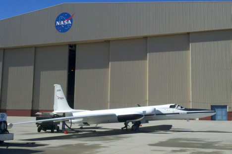
Then, around 9:00, the aircraft took off (image below). It turns out, most of the route was pretty nice … except for over the ocean, which is what we really needed, as that was missed during the December mission.
We’ll have to get ocean data on the next flight.
Tomorrow, I’ll write a bit about the aircraft associated with MABEL …
March 19, 2011
With three sea ice flights successfully behind us, and the airport being closed on the weekend, we had a day off from operations, and took advantage of the great activities that are coordinated by the Community Center here at Thule AFB. Today’s trip was a hike to the Ice Cap. About two dozen folks (mixture of Air Force Personnel, Danish Workers, and NASA IceBridge Team Members) piled into 4×4 trucks, and headed off base about 20 minutes drive. The last 5 minutes of the drive was “off-road” and we went as far as we could until 2 trucks got stuck in the snow. After a few minutes of shoveling and getting everyone back on sturdy ground, we took off for the 45 minute hike to the ice cap.
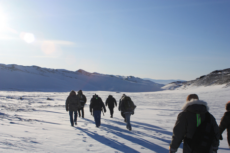
Heading out on our hike towards the Ice Cap. Credit: LCDR Woods
It was a pleasant walk, over mostly hard ground, with some areas of soft snow making for a good work out. We took several short breaks to stop and listen. The silence was incredible. There was no breeze, and absolutely no noise. No cars, no power poles, no animals (that we could see at least), just absolute silence. It was a very cool experience. We arrived at the area where the ice cap is exposed, and took some photos. The exposed blue, white, and brown banded ice was another breathtaking sight that I had never experienced before. After another few hundred yards down the trail, we arrived at the sledding hill with another amazing vantage point after climbing to the top.
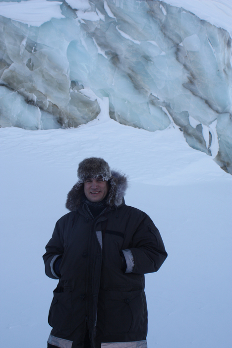
LCDR John Woods stands in front of the exposed ice cap, in which bands separate the different layers of ice. Credit: LCDR Woods
On the walk back, I found some fox tracks in the untouched snow that made for a great photo. There was no sign of the fox around, just for its left over paw prints in the fresh snow.
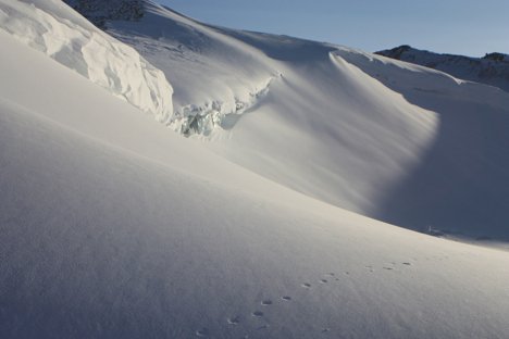
Fox tracks cut through the otherwise undisturbed expanse of the snow in front of the ice cap. Credit: LCDR Woods
We finished the walk with some Hot Chocolate and cookies, warming up and swapping stories about each person’s favorite part of the hike.
March 18, 2011
Today we flew again and went right by the North Pole! The NASA P-3 went 2 degrees to the left of it, if you picture looking straight down on top of earth!
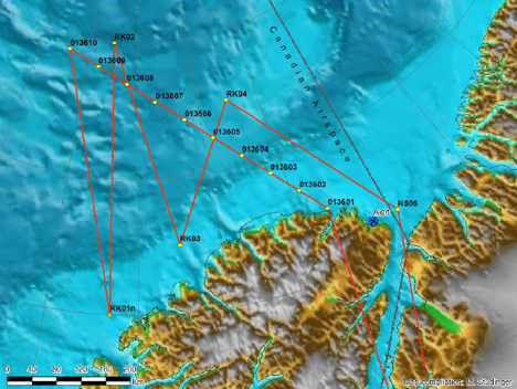
Sea ice mission ZigZag West along an ICESat orbit and some north-south trending transects that sample the gradient in sea ice thickness north of the coast of Ellesmere Island. Credit: NASA/Michael Studinger
The flights are usually about 7-8 hour missions so I woke up early and went to breakfast. After we got on our track over the sea ice, it was difficult to get good measurements because the clouds were so thick (the Lasers need clear skies). So the plane went to 1000 feet, which is very low. This made it exciting to look out the windows and see the sea ice below passing by really quickly. After we descended though, the laser altimeters began working better and collecting good data.
We landed around 1530 and I headed back to the North Star Inn to meet with a NOAA scientist Larry Connor. Dr. Connor wrote a paper looking at laser and radar altimetry measurements, so it was great getting to ask him questions about his work. In just a twenty-minute conversation with him, he was able to answer all the questions that were forming in my head from hours of reading and studying his paper. Tonight is my last night here so I went to the Top of the World club to say my goodbyes to all the engineers and scientists I got to meet during my trip to Thule AFB, Greenland.
I learned so much in my short week here; all the equipment onboard is so complex and it measuring features of the Arctic in order for scientist to study the change this environment is undergoing.
It was reassuring knowing that there are so many intelligent and hard working people looking at the poles and trying to understand the dynamics of them. I am excited to continue studying polar oceanography and hope to continually learn more as I pursue a higher education in graduate school.
March 24, 2011
Greetings from Palmdale, California.
Our Goddard-based team is at Dryden Flight Research Center testing an instrument named MABEL, which stands for “Multiple Altimeter Beam Experimental Lidar”. MABEL is an ICESat-2 simulator, which we fly the instrument at high altitudes over various terrain to test the satellite’s measurement concept.
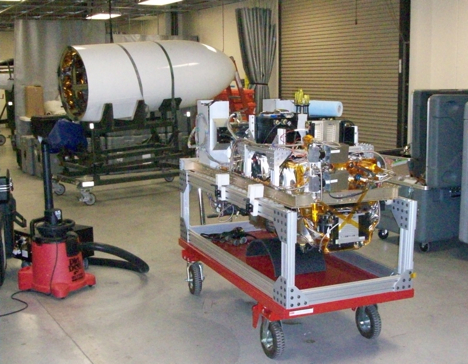
We were out here last December for MABEL’s maiden voyage. For the December deployment, we flew 5 test flights that included targets that would tell us about MABEL’s capabilities, such as ocean water, lake water, snow, salt flats, mountains, vegetated regions, and places where we had other datasets for ground control. I’ve attached a photo of MABEL before she entered the nose cone of the ER-2 (below).
We’ve returned to Palmdale to fly MABEL again to test a new set of filters that have been added to the instrument to filter out background noise, stemming from natural sunlight. These ‘etalon’ filters are a critical component to MABEL’s design, allowing us to fly during daylight hours.
So instead of being in the aircraft hanger until the middle of the night (like we were in December), we now have to arrive to the hanger super early … This ‘morning,’ two of us were awake between 3 a.m. and 3:30 a.m. In order to finish out this day, I have now had approximately eight cups of coffee today. I’ll write about our first flight tomorrow. Stay tuned …
About the blogger:
While at NASA, Kelly Brunt has been working on ICESat-2, where her duties include flight planning for Multiple Altimeter Beam Experimental Lidar (MABEL). MABEL is a high-altitude, airborne instrument intended to assess the new lidar concept associated with ICESat-2. Read more about Kelly here.
March 17, 2011
Another early morning wake up, with a quick check of the weather. I went to bed last night with snow falling, and not so promising satellite pictures showing a fairly significant storm system off to our west. I was thinking that we would be cancelled due to weather, but woke up to surprisingly calm conditions. The system skirted by us to our west and headed due south rather than east. The weather conditions here in the Arctic are much different from home, and I am still trying to figure out how the weather systems move about the area. I created a picture from this morning’s satellite image, with approximate locations of Thule, and our proposed flight path. You can see the major part of the weather was to our west, and we had some high clouds in our operating area to the north towards the pole.
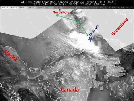
IR Satellite Image from 0444 local. Large area of cloudiness to west of Thule, but cleared out by our departure at 0815 local. Area of high clouds near the flight path in vicinity of North Pole, that we went down to 1,000 feet to get under. Imagery is courtesy of Environment Canada
Today’s mission was another satellite underpass track, this time for the European Space Agency CRYOSAT platform. Take off was under relatively clear skies, and we got some great views of the surrounding mountains and glaciers around Thule. I am told that this was nothing compared to the upcoming land ice flights, but I was still in awe with the beauty of the ice flowing towards the sea, and the morning sunrise reflecting off the snow covered mountains. The calving front was clearly visible from our low altitude just after take-off. This is the area were the land ice meets the water, and at this time of year the water is still froze, so the sea ice sort of acts like a buffer to hold up the glacier. During the summer months, the sea ice retreats due to the warmer air temperatures, and the glacier flows freely into the water, and calves into icebergs.

Calving front of a glacier around Thule, Greenland. Credit: LCDR Woods
About an hour and half into our flight, we reached the beginning of the data collection line. We dropped down to 1500 feet in attempt to get under the clouds to allow the instruments on board to collect data. Today, the cloud deck was down around 1,000 feet, so we had to fly below that level. This made for some spectacular viewing of the sea ice conditions.
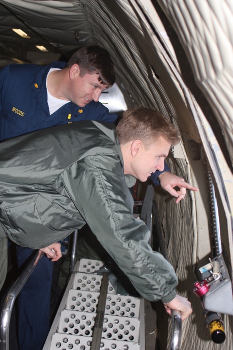
LCDR John Woods and MIDN 1/C Eric Brugler, observing sea ice conditions in the Arctic Ocean. Credit: Jim Yungel
After about 2 hours of flying our survey line, we had reached approximately 87.5 degrees north, only 150 miles from the North Pole. The P-3 made a wide S turn to back track on the same line that we covered on the way out. This gives the instrument teams, twice the data to be compared to the satellite that would be passing over our heads, taking similar measurements. Another 2 hours of data collection on the way back, and now we have just broken off the survey line and are heading back to base.
Happy St. Patrick’s Day everyone! I have yet to see a single sign on base advertising any sort of celebration, so we might just have to create our own. Midshipman Brugler departs tomorrow morning on the rotator flight back to BWI airport, so we will go out in search of some congratulatory Corned Beef in honor of his departure. I will be staying on here in Thule for at least one more week, hoping to get on the flight across the Arctic to Fairbanks, Alaska to survey the Navy Ice Camp. Weather permitting of course!
