
Wallops Island, Virginia 6:00 p.m. EDT
From Jon Ranson:
I’m back at Wallop’s this evening after a quick trip back home. Last evening we made the decision to not fly today, so the DBSAR RAID could be fixed. I’m not an engineer, and couldn’t offer much to the RAID-fixing effort, so I had a little free time on my hands.
The news from here is great. It looks like the instrument is fixed and should be ready to roll in the morning. We’re planning to leave early in the morning, do a quick check-out, give a few high-fives for a healthy instrument, and then head to Maine. We should get two full days of data collection before we have to turn home on Friday evening. It’s less time than we’d planned, but it will be good time, and I’ll happily take it.
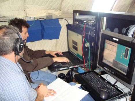
Yesterday I was under the impression that the parts had to be special ordered and would arrive early in this morning. It turns out that our engineers were more resourceful than that. They took an evening ride out to Salisbury, went shopping at Best Buy, and bought what they needed to get the job done. They got up very early yesterday morning and worked all day long on this. When I arrived around five o’clock this evening, they were still hard at work. So now, thanks to the long hours, resourcefulness and great skill, Rafael and Martin got it fixed. The DBSAR RAID looks very stable, and we expect it to work very reliably in the air.
The SIMPL team took the opportunity to tweak their instrument, too. Phil Dabney discovered that the SIMPL system was using almost all the capability of their UPS (uninterruptible power source). The instrument performed fine with the UPS, but there was very little reserve to deal with extra power needs. So the team managed to find a replacement with greater capability, and they are happier with their stability now.
Tomorrow’s plan is to get up very early, eat a breakfast and grab a “picnic” lunch at the local deli, and meet at the hangar at 6 AM. The flight crew will give us a fly/no fly decision, based on the weather situation at that time. Because that pesky hurricane is still creeping closer, there’s a bit of doubt that we’ll go, but I tell you right now, we’re all totally dedicated to getting this mission accomplished if there is a safe way to do so.
Once we lift off, around 8 a.m., we’ll fly to the Maine sites, and work hard acquiring data from all three instruments for at least 6 hours, maybe more. We’ll stay overnight near the Bangor airport, then get up early and fly another full day.
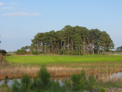
Our original flight plan called for at least four days of flight. We wanted to collect data at Howland Forest and other sites in Maine, Bartlett Forest in New Hampshire, a boulder field in Pennsylvania, and some sites in Quebec. These sites were carefully chosen to give us access to a wide range of forest types as well as a site with no forest at all (the boulder field). It’s really important to see how these instruments perform with various vegetation sites.
We also selected sites that have had recent measurements made in the field, so we can compare to recent ground truth. Many of the sites have been measured this year for the Carbon Monitoring System’s Biomass Pilot program, so we’ll be able to compare our biomass measurements against their measurements. The Carbon Monitoring System is a NASA initiative in which researchers in biomass and flux (atmospheric carbon) will create data products of carbon in terrestrial vegetation and in the atmosphere, and these products will be of known accuracy as well as be useful to end-users, such as researchers, forest managers, and policy makers.
When measuring forests, we have long considered that on-the-ground, first hand measurements are the gold standard for accuracy. When we work to improve remote-sensing instruments, it’s important to compare to this gold standard, and that’s what we are trying to do by collecting data over sites with recent ground-truth measurements collected. Using the CMS sites has the additional benefit of providing data to that program which we hope can enhance their data regarding the biomass of the area. We hope that the Eco-3D can prove very valuable to programs. like NASA’s CMS, which are designed to enhance our understanding of forest biomass well as provide data of known accuracies that can prove useful to fill a variety of needs.
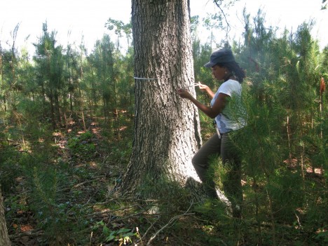
One of the primary places we are interested in measuring tomorrow is Howland Forest. Portions of this forest were measured in 2009, 2010, and the CMS pilot measured some parts of it earlier this year. We have sent a crew to measure this week as well, in conjunction with our flights, so we can have ground truth that is nearly simultaneous with our instrument collections. That crew is led by Guoqing Sun, a scientist from Goddard. The crew members are living in cabins near the forest, and have been out every day gathering ground-truth data for us.
Another scientist, Miguel Roman, is driving a car through the areas we plan to measure with Eco-3D. He is surveying the sites visually to gather impressions we can compare with the flight data, and is also taking measurements of aerosol thickness with handheld sun photometers. This helps the program in various ways – since our instruments are gathering information through the atmosphere, it is helpful to quantify that variable.
The entire campaign is designed to have a week-long set of flights to the north, a week-long set of flights to the south and some local flights in Maryland over sites where the forests have been extensively measured by NASA very recently, both for the Carbon Monitoring System and other NASA research programs. In conjunction with that, we have field crews out taking various measurements. The goal is to gather as much data as possible, in as many ways as possible from specific sites. The sites are chosen to give us as many types of forest as possible – from the boreal forests in Maine to the Mangrove forests in Florida.
Despite being forced to compress a week’s measurements into two long days, we’ll still have plenty of time and flight hours to gather excellent data and produce a good result. Weather permitting, we’ll be in the air and gathering that data early tomorrow morning.
so much excellent info on here. 😀