
Western Siberia is, in places, remote. However, much of the region can be accessed by a system of roads and rivers. When planning this expedition, the scientists needed to find the location of GLAS footprints – measurements taken by the Geoscience Laser Altimeter System aboard the ICESat Satellite – in the area as well as find routes to enter those footprints. The goal of the expedition is to measure by hand, on location, as many GLAS footprints as possible in the study area. This is called ground-truth validation, and is an essential part of understanding data acquired by remote sensing instruments.
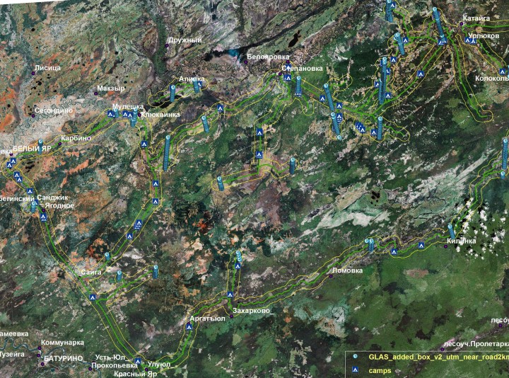
The image, above, shows the anticipated study area. The background is true-color, so green represents vegetation, water is blue, soil or dried vegetation is brown and clouds are white. Overlayed on the background, roads are represented by green lines. The yellow lines paralleling both sides of the road represent the desired study distance from the road. The wide, blue, linear stacks represent the location of trails of GLAS footprints that were measured as the satellite passed overhead. There are multiple tracks, representing many overpasses made over several years. The blue triangles with a symbol of a white tent are areas that have been identified as potential campgrounds. The city names are in Russian.
The Team will travel along roads to a campsite, set up tents and then head to the forests to make measurements. Each GLAS footprint measures about 60 m (197 ft) in diameter, and they are spaced approximately 170 m (558 ft) apart. In an average day, seven people can measure 8 – 10 footprints with a high degree of accuracy. They will obtain measurements of tree diameter at breast height (DBH) and tree height, and will inventory the tree species. They will also collect data for fire-return studies, note general soil type and drainage, collect data on insect damage, note forest regeneration, and keep their eyes and minds open for any unusual observations while in the forests.
1. aside from being red and fishy, what is the caviar?
2. although plants constitute the bulk of the biomass animals contribute to the ecosystem. What observations of animals have you made ?
3. is there a way a person could arrange a tour such as yours for birding?
Jay
Could regular citizens of our planet assist these scientists as well? Maybe even a student exchange???