By Eric Lindstrom
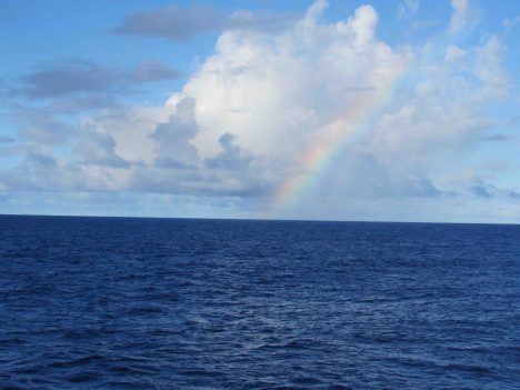
Blue sea and sky, with a nice rainbow.
The beauty of sea and sky in the open ocean of the tropics is a wonder to behold. There seemingly are an infinite number of ways to mix the sun, clouds, water, wind, and stars into poetry and science. For today I choose only a tiny slice of this infinite variety: Today is all about the blue.
Blue is the fundamental background of the sea and sky in the tropical oceanic regions of the Earth. The preferential scattering of blue light in the full spectrum of visible light from the sun accounts for the blue sky. Most open-ocean regions have remarkably clear water, which when illuminated by the sun also takes on a deep blue hue. Other visible light is absorbed quickly in the sea and it remains for the blue to be scattered back and illuminate modest depths.
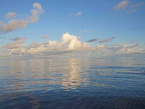
Sea and sky on a very calm day.
While clear seawater is blue, if particles are introduced to the water such as floating microscopic marine organisms (plankton) or silt and mud, it can be transformed shades of green, red, and brown. However, clear blue seawater does not indicate the absence of life: Blue ocean water is still a sea of life with submicroscopic picoplankton and marine viruses making a life in the chemical soup that is seawater.
Oceanographers like Carol Anne Clayson from Woods Hole Oceanographic Institution use a special instrument, the HOBI a-Sphere Spectrophotometer, to measure upper ocean absorption of light. The instrument uses an internal light source to measure absorption characteristics as it is lowered from the ship. This measurement is critical to estimating the transfer of radiant heat energy across the air-sea interface. Here in the SPURS-2 field site, the water is so clear that sunlight penetrates well below the well-mixed surface layer and is lost to typical energy budgeting exercises. So, the question of how much energy is lost in such calculations is a big question (considering the vast extent of this very clear blue ocean) when climate studies demand a careful accounting of heat flows to and from the ocean.
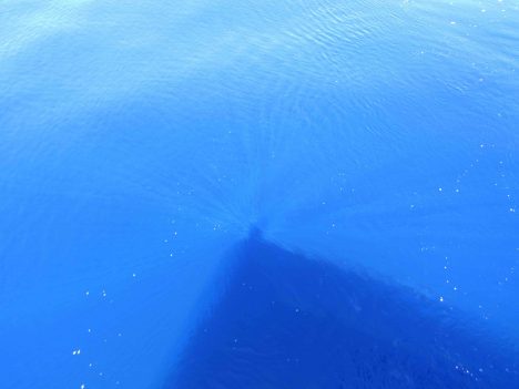
Blue ocean, with sun rays around Eric’s shadow.
It is often true and hard to imagine that those days when sea and sky are blue and the harsh tropical sun sees no cloud are when the atmosphere is feasting on its fuel from the ocean, water vapor, through the process of evaporation. We all know evaporation from the ocean is invisible, but I would use poetic license and say that evaporation is really blue! It is a clear dry wind over a warm ocean (e.g. trade winds in the tropics) that fills the atmosphere with the moisture that accounts for most of our rain. Like yesterday, when it was clear blue sky from horizon to horizon with a gentle wind leaving the deep blue ocean without a single whitecap, it is all blue and it is bonanza for evaporation.
Raymond Graham and Jim Edson from University of Connecticut (whose color brand is navy blue!) are making careful measurements of both evaporation and precipitation during SPURS-2. Despite our focus on salinity and the role of rain in forming the eastern tropical Pacific fresh pool, we must completely account for all the moisture that flows between atmosphere and ocean. The rain is visible and tangible. The evaporation is invisible but critical to the moisture budget. They are also profiling the temperature and moisture through the atmosphere using instruments on balloons (learn more about this topic in a later blog post!).
The R/V Revelle blue meets ocean blue.
Blue is the color of our daily lives in R/V Revelle. The ship is blue. The crew’s t-shirts are blue. The ocean is blue. The sky is blue. The rods and cones on our retina normally get a color workout every day. Out here, some of our retinal cells are getting a six-week vacation. The 2 percent of our cone cells tuned to blue light are getting no rest at all. Maybe that is why the colors of land (greens and reds) look so vivid that first day back ashore? Or maybe, being back ashore just makes an oceanographer blue!
By Eric Lindstrom
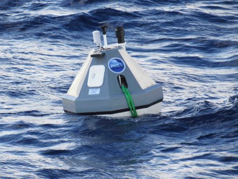
One of the two buoys from the NOAA Pacific Marine Environmental Laboratory used during SPURS-2.
SPURS-2 is basic research seeking to improve our fundamental understanding of the surface salinity of the ocean. How does the salt content of the top layer of the ocean vary, and why? However, the question of today’s blog is: How should such work be supported?
While NASA is the prime investor in SPURS (so we make the most of our salinity measurements from space), significant components are made from the National Oceanic and Atmospheric Administration (NOAA) and the National Science Foundation (NSF). And much of the oceanographic equipment on the used on the ship has origins in work supported by the Office of Naval Research (ONR). All these government agencies (NASA, NOAA, NSF, and ONR are also known in DC circles as “the 4 Ns”) working together on the ocean – how does that work? Many of the people on the ship are from universities but supported by grants from these federal agencies. Wherever you peek at oceanography, you will find national governments behind the curtain….
If there was any doubt in your mind about whether oceanography should be an enterprise supported by U.S. federal tax dollars, this blog post is for you. I would like to provide you with several compelling lines of reasoning – the federal case for oceanography.
One line of reasoning is that such research is a public good. This, roughly, is something that has a broad group of beneficiaries and few identifiable investors that can make it happen. All taxpayers, together through government, support public goods. There are public goods that we can easily relate to –national defense, weather forecasts, national parks, and interstate highways, just to mention a few–, and I would add oceanography to the list. Understanding how the ocean works has broad benefits in the areas of weather and climate prediction, ecosystem services, national security, transportation, recreation, and public health. There are few individuals or companies that can meet the challenge of fulfilling the need, but the necessity for the public good is great. The federal government is the enterprise to support the needed research. Private industry can certainly build on the knowledge of the ocean, but the generation of knowledge is required first.
Modern global oceanography really grew up out of the war effort in the 1940s. That is when submarine warfare, amphibious landings, and search and rescue led to sizable government investments in understanding the ocean’s physical, chemical, and biological characteristics, including specific like the waves and tides on landing beaches. Of course, navies for centuries have been on the leading edge of oceanographic knowledge generation but it was the continuation of the work after the war that led to the civilian oceanography community we have today in the United States. The U.S. Office of Naval Research was important in setting up the Ocean Sciences section at the National Science Foundation. The National Oceanic and Atmospheric Administration formed in 1970 to consolidate weather, coastal, and fisheries services that have a far deeper history in government. NASA formed in 1958 to organize space technologies that would later gain favor in viewing the ocean from low Earth orbit.
James Watkins, a former Chief of Naval Operations and Secretary of the Department of Energy, was an articulate advocate of the case for oceanography having a significant role in winning the Cold War. He thought the US supremacy of the seas certainly had been critical in victory.
Another line of reasoning and a corollary to oceanography being a public good is the advent if the Law of the Sea in 1982. This legislation extended the reach of sovereign nations well out into the sea by declaration of 200-nautical-mile Exclusive Economic Zones. Governments, almost overnight, had new territory (beyond prior 12 nautical mile political boundaries) with marine resources to explore, characterize, and manage. Many countries responded to this challenge with comparable expansions in marine research and capabilities such as new research vessels and ocean surveillance.
If the Law of the Sea compelled oceanography through national self-interest, international cooperation is also compelling the federal case for oceanography. The fact that the ocean occupies 71 percent of the Earth surface suggests the need for many nations to work together to understand the whole of the ocean. In fact, that is the case. The 4 N’s are central to a number of joint international accomplishments in recent decades. The World Ocean Circulation Experiment, the Joint Global Ocean Flux Study, and the World Climate Research Program have deepened our knowledge of the ocean through the collaborative work of these US agencies working with international partners. There is strong coordination internationally through the Intergovernmental Oceanographic Commission and its sponsorship of the Global Ocean Observing System. SPURS-2, as with many other expeditions focusing on ocean processes, is led by one national agency (in this case NASA) with contributions from the others. Audrey Hasson is aboard R/V Revelle from the French space agency CNES. NASA works closely with many international space agencies on the view of the ocean from space. NOAA collaborates with many international partners on the in situ ocean monitoring networks of the Global Ocean Observing System.
There you have my quick summary of the federal case for oceanography – public good, Law of the Sea, and international collaboration – all compel a strong federal government role in ocean research and observation.
By Eric Lindstrom

Monkey makes its own mess!
Long ago on a planet very similar to our own, oceanography was done without the Internet or regular communication with shore. It required careful planning and forecasts of the conditions to be encountered were vague at best. Executing the original plan of work for a voyage was always a good objective.
Unlike those days on that planet, the shipboard work of SPURS-2 seeks to optimize our operation as we go by depending on a “dry team” ashore for a daily flow of information. The information comes from a number of sources including satellites, in situ data (data collected in place), models, and combinations of these sources. The daily flow of information comes to us via the Internet in a “tarball.” In computing, tar is a computer software utility (originating from Tape ARchive) for collecting many files into one archive file, often referred to as a tarball. Scientists on R/V Revelle receive the daily tarball assembled by our dry team at the NASA Jet Propulsion Laboratory (in association with many SPURS-2 scientists ashore). The tarball contains files for daily weather and oceanographic analysis and a wealth of ancillary information. The tarball is information desired by the team aboard the ship, a key point that should not be overlooked in the following discourse.
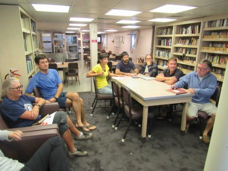
SPURS-2 planning is a daily occurrence in the R/V Revelle library. From left to right: Janet Spintall, Denis Volkov, Kyla Drushka, Ben Hodges, Audry Hasson, Julian Schanze and Jim Edson.
Well, you can see where I am going with this: a tarball is also a blob of petroleum that has been weathered after floating in the ocean, sticky marine debris from the age of oil spills. With all due respect to the efforts of the dry team, commonality of the computing and oil tarball terminology becomes all too clear when one tries to reconcile the complex flows of data from both the tarball and the vast array of instruments on the ship. The tangle of seemingly conflicting information can make you feel like you are dealing with a tarball of the sticky black variety!
The tarball does focus our attention by feeding back to us our own observations. After R/V Revelle has deployed moorings, drifters, and floats we might receive back meteorological data from the central WHOI mooring, profiles from the NOAA moorings, trajectories of surface drifters, and profiles from the Argo floats. This real information may or may not conflict with what we imagined we would see (and built our plans around). So, this tarball pushes us into consideration of whether our plans going forward need revision or remain sound.
For example, the tarball is always an implicit invitation to re-consider the planned work to take account of current or forecast conditions. Ostensibly this information enables us to make the most of our valuable ship time. However, having a constantly evolving plan of action is rough on people and their routines. Plans tend to lose their certainty.
Of course, proposals are funded and years of work are banking on our executing a planned set of measurements. However, the decisions are difficult, if we planned to collect seven days of Surface Salinity Profiler data in rainy conditions and our planned operations turn out to be south of the actual rains for the previous two weeks, do we change our plans? Or, will Mother Nature bring rain to us in the coming weeks if we simply execute the plan with which we came to sea? The tarball gives us some weather projections, satellite rain rate and cloud maps, as well as current and salinity patterns in the ocean and model forecasts to help with the decision-making. Unfortunately what seems clear and useful to those at desks thousands of miles away, can be less than clear and ultimately confusing when working on an isolated patch of ocean far from regular observation. The effort to make good use and sense of the tarball is one of the additional challenges facing modern oceanography.
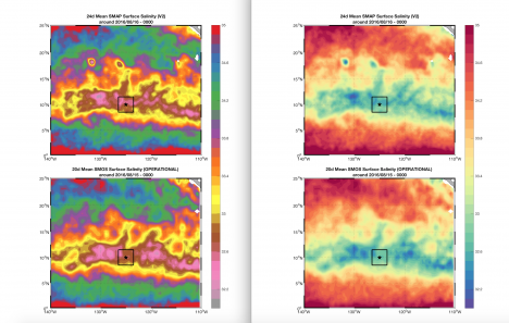
Two-panel plots of satellite salinity from the SMOS and SMAP missions. The only difference is the color scale; it is kind of a Rorschach test for oceanographers. Do you see fronts in one and not the other? Well, they are the same! What you see and interpret can be biased by how you present the information. That is another sticky mess in the tarball.
Before the tarball, seagoing oceangraphy was simpler (and more dangerous) and plans were simply to be executed. With the tarball, science is safer and more nimble and plans are malleable. I think that for us, older humans, the modern way with the tarball is more stressful. Or maybe, if you came of age with the Internet, life without the tarball is unimaginably silly and stupid. For a young oceanographer the science IS the sticky mess inside the tarball!
Whatever the reality, our information age has made a day at sea a challenge in environmental analysis. No more hoping, imagining, or guessing – it is all in the tarball if only you can figure it out!
By Eric Lindstrom
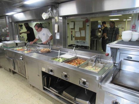
Food service on the R/V Revelle.
Food aboard the R/V Revelle is a cornerstone of happiness and good morale. Jay Erickson and Richard Buck are the cooks during this voyage and have many years of experience working together on R/V Revelle. I followed their daily routine all day on Friday, September 2, so that I can give you some beyond-consumer incite about food on the R/V Revelle. I will stipulate that their work is very good indeed and that we have been getting well fed. Since scales don’t work at sea, no weight gain can be observed. So says the fat blogger.
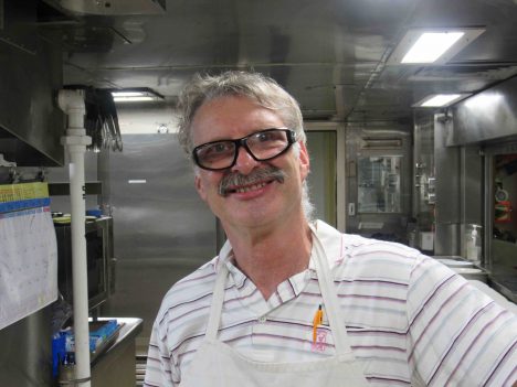
Jay Erickson, Chief Cook on the R/V Revelle.
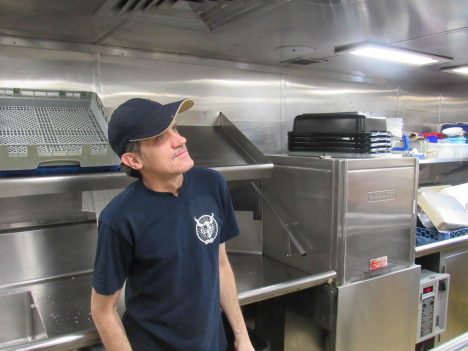
Richard Buck, Cook, R/V Revelle.
I think it is best to describe this important aspect of life on R/V Revelle in two ways. First is the routine that makes food service run like clockwork every day. Second are the secrets or magic of shipboard food service that those on land might find curious or amazing. I can touch on only a few highlights.
I’ll start with the clockwork routine. Richard and Jay alternate work assignments. Each day one them does the hot food preparation and other has salad/cold food preparation, cleaning/dishwashing, and supply runs to the stores (three decks down). The next day they switch. The key menu options for hot food are generally decided on the prior evening. Only one day has a predictable menu – Sunday is steak day! Jay and Richard’s workdays are over 12 hours long with two short breaks. That is a heavy, relentless duty.
Breakfast preparation starts at 6:00 am. Breakfast food options are those of a typical American diner (e.g., eggs several ways, several meats, potato, pancakes, oatmeal, cereal, fresh fruit), without the short orders, and do not vary substantially from day to day. Most people do not vary in their breakfast food choices so I’d characterize it as the constant, dependable meal (least challenging for the cooks).
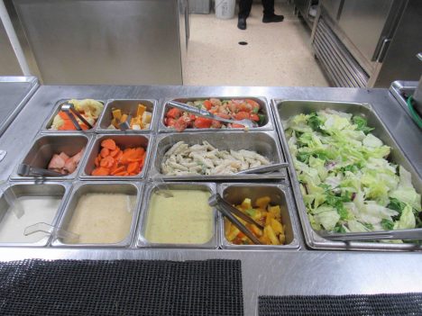
Salad bar at every meal.
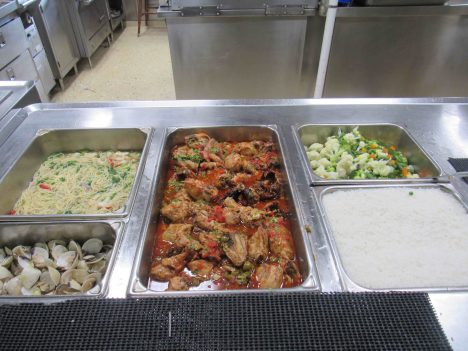
Hot meal of Balboa chicken and shrimp noodle soup.
After a short break from about 8:30 to 9:00 am, lunch preparation begins with galley and dining room cleaning. Typical lunch and dinner menus include a featured main course, a couple of side dishes, a vegetarian option, and a soup. After lunch cleanup there is another break in the action from around 1:30 to 2:30 pm. Some preparation for dinner will have been started during the lunch service.
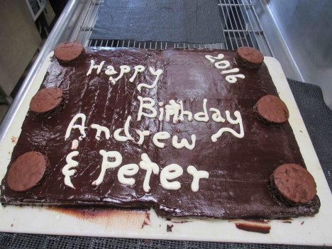
Birthday cake for Andrew and Peter.
Dinner preparation includes renewal and refreshment of the salad bar, bread baking, and work on the main meal from soup to nuts, as they say. Every day there are some extras or special events as well. On my day in the kitchen there were two birthdays, so a decorated birthday cake was prepared over the course of the day. Likewise, fresh bread, cookies, or a special dessert might be created for the dinner service.
As I learned over the course of the day, the vast share of labor goes into food preparation and cleanliness. The R/V Revelle professional facilities allow for the rapid and efficient cooking of food for 50-60 people. However, the washing and chopping of large quantities of fruit and vegetables, and meat handling are labor intensive. So too are the good habits of kitchen hygiene that assure that everything is done right and sparkling clean at all times. As you might expect, the work is hard enough without everything being shipshape and well organized. Fastidiousness was a hallmark of Jay and Richard’s work.
There are many challenges to creation of good meals at sea. Obviously motion of the ship can be a big issue. A ship’s cook is a cook who has mastered the art of corralling sloshing food! Richard told me of attempts to bake a level cake in the seas of the Southern Ocean. Rather than having it baked into the leaning cake of Pisa, he tried to balance the sea motion by turning the cake in the oven every few minutes to counter the sloshing of the batter. In that case, the ocean won…but I think the birthday recipient appreciated the effort nonetheless.
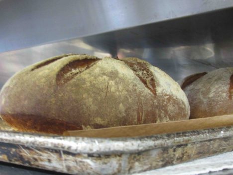
Fresh bread just out of the oven.
Jay shared an interesting secret of leftovers. Oatmeal is available for breakfast every day. Leftover oatmeal is mixed with water and yeast after breakfast and the slurry left to ferment. It is transformed by this effort of the microbes and a resourceful cook into the delicious bread at dinner!
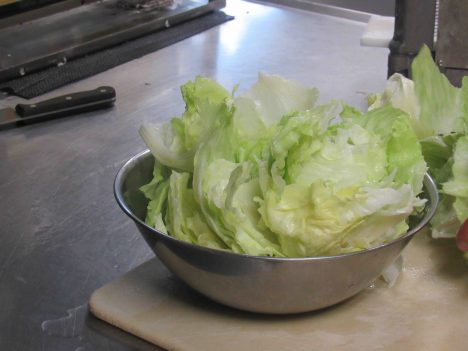
Let us admire a three-week-old lettuce, looking like it was fresh.
A great deal of science and experience goes into the food storage on a ship. Three weeks at sea and we still have lettuce and perfect avocados. That never happens for me at home! While each fruit and vegetable seems to have its own story with regard to ripeness at purchase, storage, and revitalization, the keys to longevity seem to be in the cold room temperature and humidity plus the skills of Jay and Richard to give foods a second chance. Lettuce, for example, might look finished due to a dehydrating stay in the cold storage, but skilled knife work, a cold bath, and a little secret chemistry can return lettuce to salad fitness!
We are all in debt to the skill and labor of Richard and Jay. We will feel the full extent of the deliciousness they loaned to us when we climb on the scale back home!
By Eric Lindstrom
The R/V Revelle and the Lighter-Than-Air InfraRed System (on the left corner), as seen from the Surface Salinity Profiler. Credit: Dan Clark.
Kyla Drushka from University of Washington Applied Physics Laboratory (APL) received a National Science Foundation grant to participate in SPURS-2. It is one cornerstone of our work and is entitled “Rain-Formed Fresh Lenses in SPURS-2.” The idea of rainfall resulting in freshwater puddles or lenses at the sea surface is (perhaps) easy to imagine but is very tricky to observe and study in the real world. SPURS-2 will provide a wealth of new data on this subject with which to test the fidelity of our scientific imagination.
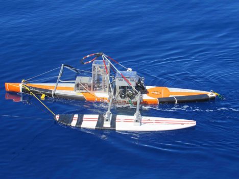
A beauty shot of the Surface Salinity Profiler.
Kyla and the APL crew have a variety of instruments aboard R/V Revelle but the Surface Salinity Profiler (SSP) is central to SPURS-2 science objectives. When you want to know the fate of rainwater after it hits the sea surface, measuring salinity (or equivalently the amount of freshwater) in the upper meter of the ocean is crucial. The profile of salinity in that top meter of the ocean is elusive for a number of reasons – technical and logistical. Technically, salinity sensors require some time and bubble-free water flow to make the measurement. However, normally the sea surface is rapidly moving up and down (because of waves!) so a sensor is not always in the water and away from bubbles until it is several meters below the surface. Finding a way to tow salinity (and other) sensors at fixed, shallow depths following the motions of the sea is another approach. APL scientists and engineers including Andy Jessup, Bill Asher, and Dan Clark designed the SSP to apply this approach.
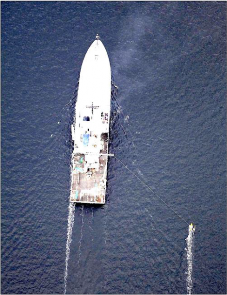
How the Surface Salinity Profiler runs outboard the ship — photo taken from the Lighter-Than-Air InfraRed System balloon camera.
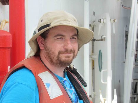
Dan Clark, APL engineer extraordinaire.
The SSP platform is a converted paddleboard with a keel and surfboard outrigger. It is tethered to the ship so it skims the sea surface outside the wake or influence of the ship. Below the paddleboard, on the leading edge of the keel, are salinity (and temperature) sensors at depths of 10 centimeters (4 inches), 30 centimeters (1 foot), 50 centimeters (1.64 feet), and 100 centimeters (3.28 feet), microstructure sensors (to estimate turbulence), and cameras. The Salinity Snake (see my last blog entry) supplements the SSP by providing temperature and salinity in the upper few centimeters of the ocean. The SSP can be towed for many hours before the instrument batteries need refreshing.
Deployment of SSP is most informative when there is a rain event, leading to stratification of the near-surface ocean with less dense fresher water on top of denser saltier water. If there is a rain event ahead of the ship, the SSP goes in the water. Then it can measure how the ocean changes over the periods from before rain, during rain, and recovering from rain. Salinity from several depths and simultaneous turbulence estimates are then used to determine how rainwater mixes into the ocean.
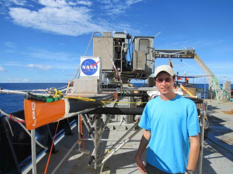
Suneil Iyer with Surface Salinity Profiler on deck (sensor to bottom left on keel)
Suneil Iyer is a new graduate student at University of Washington who will work with Kyla on interpretation of the microstructure measurements from the SSP data. He just arrived in Seattle from his hometown of Kansas City, Kansas, one week before the R/V Revelle departure from Honolulu. He just had time to find an apartment before jumping on a plane for SPURS-2. Graduate school in oceanography can be a blast of new experiences! This is not his first exposure to physical oceanography: Suneil worked on tides in estuaries during his undergraduate work at University of South Carolina.
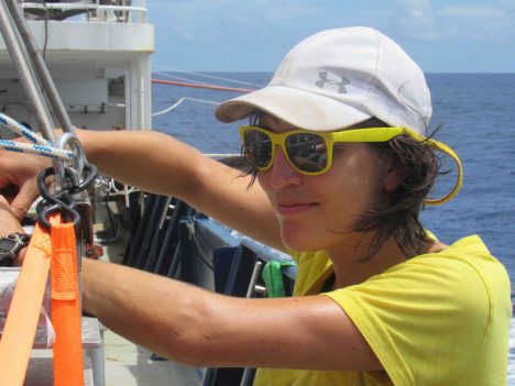
Kyla Drushka working on the Surface Salinity Profiler.
Kyla Drushka joined UW in 2014 after PhD work at Scripps Institution of Oceanography. She is now an active member of NASA’s Ocean Salinity Science Team and the mission science team for the Surface Water Ocean Topography satellite that is planned for launch in April 2021.
This blog entry goes to press near an auspicious moment on R/V Revelle SPURS-2 voyage. Saturday at 2 am (local time) is the halfway point of our expedition! In our oceanography lexicon we would call this the “hump day” for our voyage. For all you land-loving 5-day-a-weekers hump day might mean Wednesday. For the 24/7 work at sea, we really have only a “hump moment” to mark the halfway point of a continuous work schedule. Like any good NASA activity, people aboard have countdowns running to both our hump moment and our arrival back in Honolulu (8 am on Sept. 23). Amusement is in short supply!
