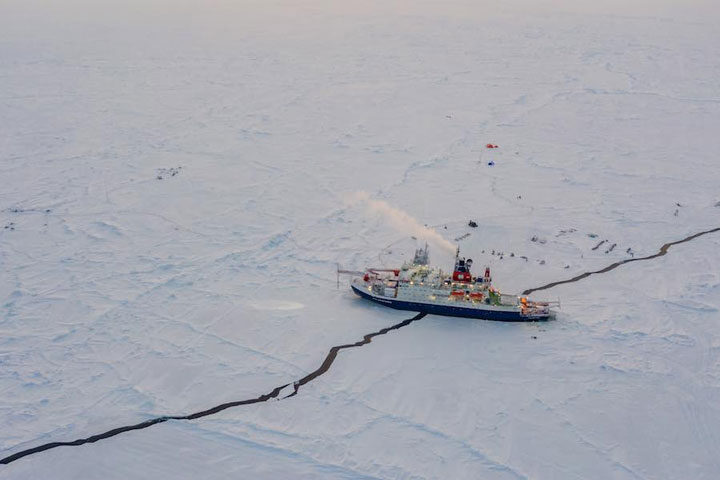
In the last post, we took a brief tour of some of the sites that make up MOSAiC. In the days since, much has changed with the MOSAiC floe. Specifically, leads have formed in the ice pack that have altered our floe map and impacted our daily schedules drastically.
Put simply, a lead is just a crack in the ice. It’s never that simple, however. There are many complex processes that determine where and when leads form, how wide they can become, and whether or not they close back up or just re-freeze. Although leads are common features in sea ice and are vitally useful for satellite measurements of sea ice thickness, they still serve as a not-so-gentle reminder that the sea ice can be extremely dynamic, and that we have to be prepared for anything when working out on the ice.
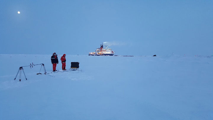
A few days ago, a small crack formed near the ship that was just a few inches wide when it was first noticed. We were still able to go out on the ice, but it was being monitored closely. About an hour later, everyone out on the ice got a radio call from the ship that it was time to return. The crack had grown to a few meters wide, and ran directly under the ship and out in both directions. It continued to widen for a few hours, but luckily this first crack didn’t form under any installations or sensitive instruments. This lead, however, was just the start.
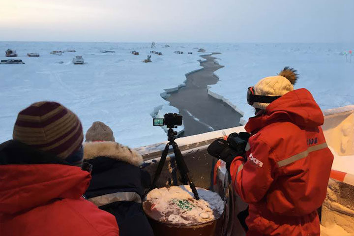
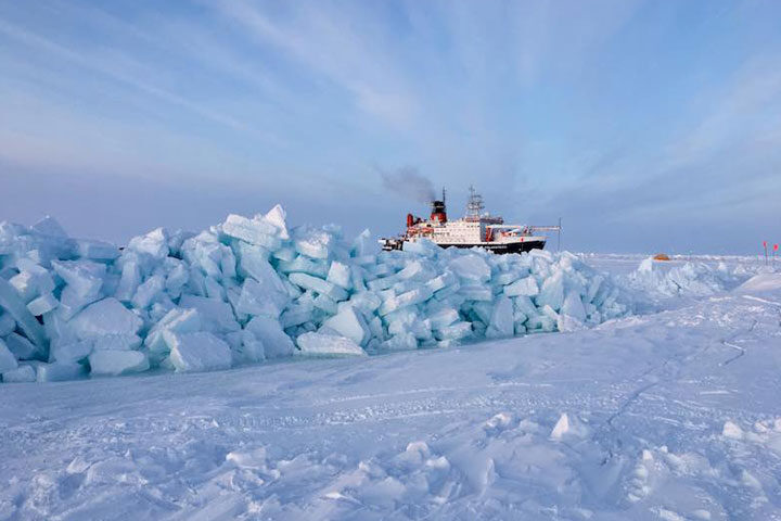
In the next hours and next days, many other leads formed off of that initial crack. Some stayed only 1 meter wide, while others grew to 10 meters or more. Almost all work on the ice has been limited, and the leads are monitored closely. The most critical lead formed between the Central Observatory and two important sites: Met City and the Remote Sensing Site. It shifted the sites a few dozen meters from their previous location, to the point where the power cables had to be disconnected before they snapped.
While the leads themselves pose threats to the instruments and infrastructure on the ice, they are only half of the concern. When (and if) the leads close again, there is a possibility that ridges could form when the two sheets of ice collide together again. Ridges can grow to several meters tall and would crush anything that was caught in the middle. For now, we are keeping an eye on everything that is on the ice in order to limit any impact that the leads or ridges may have. We also keep our fingers crossed that the ice stabilizes soon!
Floe | flō | n. A sheet of floating ice.
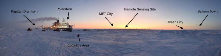
Central to the entire MOSAiC Expedition is the MOSAiC Floe: a large sheet of sea ice that was carefully selected back in October as the ideal place to anchor Polarstern for an entire year. It was chosen due to its size, structure (a mix of thick multiyear sea ice and thinner first year sea ice), and forecasted drift trajectory. Over the past five months, it has become a second home for many scientists. Here’s a brief tour of our workplace:
The Central Observatory (CO):
Nearest to Polarstern, the CO is the primary place where measurements are taken, both from continuously operating instruments and from sampling trips off of Polarstern. It houses many installations, from small stakes just a few inches tall, to larger huts and tents that can comfortably fit a few people inside, to 25-meter-tall towers with dozens of instruments installed. Most installations are grouped into ‘cities’ by scientific discipline. There is MET (meteorology) City, Ocean City, Balloon Town (for weather balloons – not clowns), the Remote Sensing Site, and the ROV (Remote Operated Vehicle) Site, to name a few. There are also clean areas dedicated to the sampling of snow, measuring ice strength, and studying biogeochemical processes.
Throughout the CO, there are carefully placed roads that lead from Polarstern through the Logistics area (where snowmobiles and other gear are parked) and to the different cities. Perhaps most importantly, there is also a ‘trip wire’ alarm around the CO that is able to send up a signal flare if a polar bear walks into it, providing an additional safety measure when out on the ice.
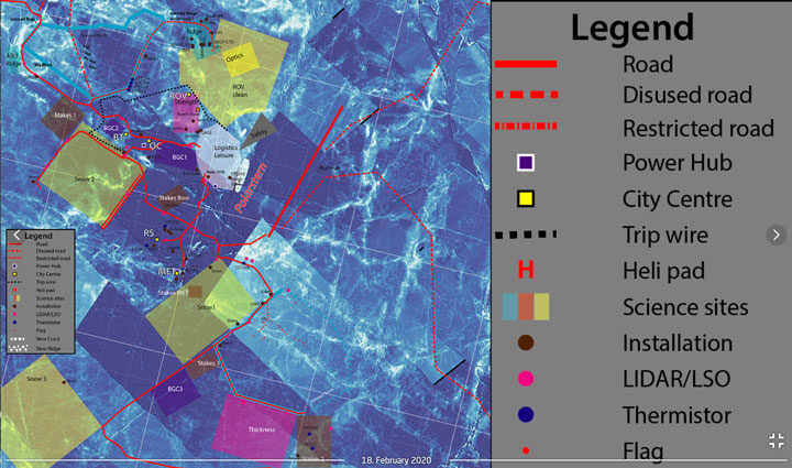
Area II:
Outside of the CO is known as Area II. This mainly houses the “Dark Site” – a place where sea ice cores are taken each week. The Dark Site consists of two different locations from which cores are drilled: a first year ice site and a second year ice site. This area is located far from the lights of Polarstern and kept as dark as possible, so as not to disturb some of the ecological work that is going on. During the winter darkness, anyone visiting the Dark Site had to use a red headlamp, which has been proven to have the least impact on the organisms living below the ice. Due to the distance away from the CO and Polarstern, visiting Area II requires additional preparation and safety gear. My main task on MOSAiC is drilling sea ice cores, so I will venture to Area II at least once per week during leg 3.
The Distributed Network (DN):
Furthest from Polarstern is the Distributed Network, which is home to exclusively autonomous instrumentation. The DN sites are not part of the MOSAiC Floe, but instead range from around 5 kilometers to over 30 kilometers away from Polarstern. Almost all sites require a helicopter to visit, an usually these visits consist of fixing broken instruments or changing batteries. The purpose of the DN is to have measurements far from Polarstern, in order to determine the representativeness of the MOSAiC floe with respect to the ice in the rest of the Central Arctic.
Together, these areas make up the field sites of MOSAiC. It’s a pretty cool place to work!
The MOSAiC Leg 3 team is officially on board Polarstern, and science activities have quickly begun.
The first few days on board were filled with handover activities from the previous leg of the expedition. Leg 3 scientists met with members from leg 2 to get a general introduction to the instruments, experiments, and life on the MOSAiC ice floe. Given that leg 2 was on Polarstern since late December, they truly are experts in the scientific activities occurring out on the ice.
During the handover, I met with members of the leg 2 ice team and visited different sites around the floe where most of my work will take place. Since it is my first time on Polarstern, I was also shown where different labs and workspaces are located, where to find tools and instruments to take out into the field, and, perhaps most importantly, where the coffee machine is! These days were invaluable for preparing the leg 3 members for work, and even more important to ensure that MOSAiC continues to run smoothly with a new team at the helm.
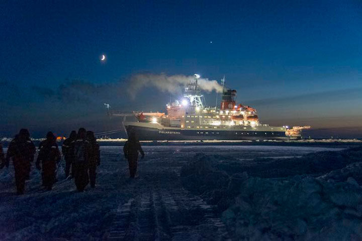
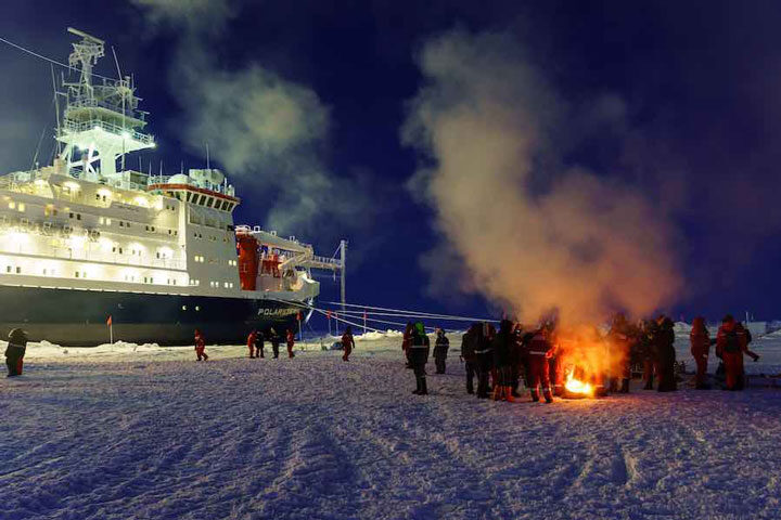
After the handover, it was time to say farewell to leg 2. We sent them off in true ‘Arctic expedition’ style with a gathering out on the sea ice between the two ships. All members from the science teams as well as the crews from both the Polarstern and the Kapitan Dranitsyn were invited for bonfires, hot tea, and group photos. The next morning, Kapitan Dranitsyn left on its return voyage to Tromsø, and leg 3 was left alone on Polarstern.
It didn’t take long for us to get started. The morning of the Dranitsyn departure, some teams already set out onto the ice to take measurements. I was working with another member of the ice team to construct a radiation station that we deployed on the ice a few days later. This type of station holds a few instruments that detect the amount of solar radiation both above and below the sea ice. It was necessary to deploy these instruments early in the leg, so that they would be operational for the first sunrise of the year. So far, we have been in a state of constant twilight – a red-orange sky for most of the day. In a few days, the sun will rise above the horizon for the first time in 2020. With this new station, we will now be able to measure the amount of solar energy that reaches (and penetrates through) the sea ice.
It has been extremely busy since leg 2 departed, but everyone is excited to be working on the ice. Here’s to a successful leg 3!
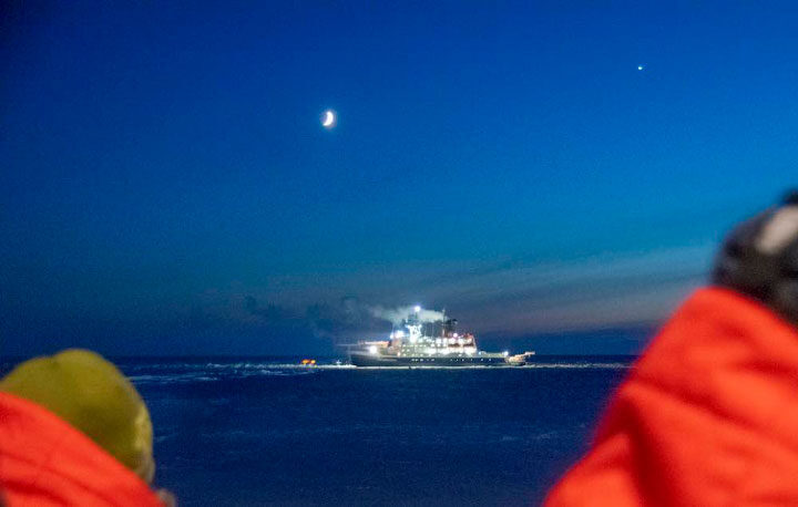
After about 28 days on board the icebreaker Kapitan Dranitsyn, our Leg 3 team has arrived to the the Research Vessel Polarstern! We are currently at 88.3 degrees N and 31.3 degrees E, less than 120 miles from the North Pole.
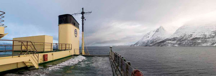
The roughly four-week transit cruise started slowly, as we were anchored in the fjord outside of Tromsø for six days. Storms in the Barents Sea led to waves around 5-6 meters (and sometimes as high as 12 meters) tall, and the ship’s captain made the decision to wait out the storm in the safety of the fjord. Once the storm passed, we sailed in open water for two days before entering the sea ice pack.
I have spent the last few years of my life studying sea ice from above –mainly using satellite and aircraft-based data. Getting to see the sea ice with my own eyes was an entirely new and extremely gratifying experience. Immediately clear was the abundance of unique features and small-scale complexities in the sea ice cover that are not easily resolved from satellite data. When viewed from hundreds of kilometers away, the sea ice often appears uniform and relatively simple. When on a ship just a few meters from the ice itself, however, one can see just how dynamic and variable (and beautiful!) the ice cover can be.
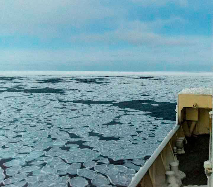
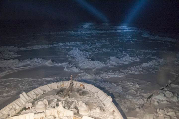
Once in the sea ice pack, our ship, the Kapitan Dranitsyn, had the arduous task of breaking through the ice to reach Polarstern. Most icebreakers only operate from spring to autumn, when the ice is thinner and can be more easily broken. We, however, were traveling very far north in the heart of winter – something that is seldom attempted due to the frigid weather conditions and thickness of the sea ice. We moved slowly at times, but eventually made our way to Polarstern. According to the Alfred Wegener Institute, the head organization of MOSAiC, this was the first time that a ship has made it this far north under its own power so early in the year, which is a new record in the history of polar research. It was truly an impressive feat, and we are all grateful for the Dranitsyn crew members who made it possible!
Given the difficulty of the mission to reach Polarstern, our transit time ended up being longer than expected. Instead of the planned two to three weeks, it took us a little over four weeks to reach our destination. While this was a long time to spend on a ship, it was invaluable for getting to know our fellow teammates, planning our tasks and experiments that we will begin when we reach the MOSAiC floe, and learning about everyone’s scientific plans for the expedition. We have been keeping quite busy, often with more than four meetings or seminars each day. Outside of our work, we spend time at the gym, have trivia and karaoke nights, and play card games. There was even a ship-wide ping pong tournament!
Now that we have arrived, we will begin our handover activities. This means that we will work closely with members of the Leg 2 team on board MOSAiC to learn our measurement procedures and responsibilities on board Polarstern. After a few days of handover, the Leg 2 team will depart for home on Dranitsyn, and we will be left on board Polarstern to officially commence Leg 3 of MOSAiC.
Now the real work begins!