The CYGNSS constellation has been operating in its science data-taking mode continuously since March 2017. The satellite hardware has been performing as designed while we make adjustments to the software on-board and on the ground so we are better able to operate smoothly and autonomously. We also spent much of the summer working on the relative spacing between the satellites, by adjusting their differential drag and, as a result, their relative orbital velocities.
An example of a typical “day in the life” for CYGNSS is shown in this video, which combines together the wind observations made by all eight spacecraft over a 24 hour period on 20 June 2017.
CYNSS wind observations (Level 3 v 1.1) made by the full constellation over a 24 hour period on 20 June 2017.
Several things are noteworthy in the video. Active storm areas appear as the regions with yellow and (especially) red wind speeds. The global coverage is seen to extend between about 38 deg north and 38 deg south latitude. If you focus on any one location within that coverage zone and note when CYGNSS measurements are made there, you can get a feel for the temporal sampling properties. In the Gulf of Mexico, for example, winds are measured during the two time interval 1300-1600 and 2000-2300 UTC. This property, that measurements are made each day during two periods of several hours each, is common to all locations within the coverage zone.
More recently, since the Atlantic hurricane season became especially active with major storms Harvey, Irma, Jose and Maria, we have focused on conducting targeted observations. This consists of predicting when we will pass over an active storm in the next several days, assembling command sequences to activate higher quality data-taking modes while over the storms, uploading those commands to the appropriate spacecraft, then scheduling additional contacts afterwards with our ground stations to downlink the higher volume of data for processing and analysis. In addition, we have been working closely with our colleagues at NOAA who operate the fleet of hurricane hunter aircraft, to coordinate their flights with our overpasses. On a number of occasions, they have been able to time the aircraft penetrations through the storm center so they coincided with CYGNSS overpasses, and to align their flight path so it paralleled the measurement track of the satellite. We are just beginning to evaluate these intercomparison data sets and intend for them to anchor our validation of high wind speed performance.
Our measurements of the major Atlantic hurricanes this season are still preliminary. The algorithms used to convert radar engineering measurements into ocean surface wind speeds have yet to be fully validated at high winds and, when they are, we will likely tweak the algorithms in order to optimize their performance. An example of CYGNSS measurements of the winds in Hurricane Harvey are shown here, taken on the morning of 25 Aug 2017. Harvey made landfall in southeast Texas that evening.
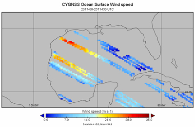
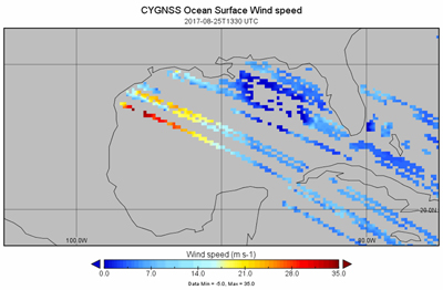
CYGNSS Level 3 gridded surface wind speed data product (v1.1). (top) at 1300-1400 and (bottom) at 1400-1500 UTC on 25 Aug 2017, prior to landfall at ~03:00 UTC on 26 Aug 2017. Hurricane Harvey is centered slightly off-shore, in the region of highest wind speeds shown in red.
CYGNSS makes measurements continuously over both ocean and land. The ocean data are used to estimate surface wind speed. The land data are sensitive to the moisture content of the soil and, in the most extreme circumstances, can be used to detect and image flood waters. This is illustrated in the following series of images of CYGNSS measurements over southeast Texas made shortly before, and then in the days after, Harvey made landfall.
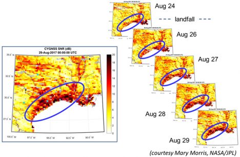
CYGNSS SNR images of southeast Texas before and after Hurricane Harvey landfall. (left) Aug 29 SNR image with coastal flooding circled. (right) Time lapse SNR images, with flooding inundation indicated by large increases in SNR.
There and back again
Of course, a title stolen from ‘The Hobbit’ but appropriate just the same. It’s Monday afternoon and the Atlantis is once again tied up to the dock. We came in yesterday on the early morning tide and quickly began the task of ‘demobilization’ – i.e., unloading the tons of scientific gear that were set up on the Atlantis for NAAMES III. It’s remarkable how quickly all that gear can be packed, labels, offloaded, and sent to shipping when demobilization is the one thing standing between 30+ scientists and their trips home. It is a keen motivator to say the least. Only a day and a half after arriving, the labs are shockingly empty. The cramped spaces once filled with instruments, wires, tubing, sampling equipment, and myriad other widgets and gadgets are now empty spaces that echo your voice. The final tasks is sweeping and mopping and then NAAMES III is finished.
Earlier in this trip, one of our bloggers mentioned the duality of time during an ocean voyage. On one hand, exact timing is essential to successful experimentation and for keeping activities running smoothly on a very busy schedule. On the other hand, time seems to hold little meaning as the days blur together and weeks pass with little recognition. This duality is particularly pronounce when the voyage is done. The memory of untying the ship and heading out to sea is still so vivid in our minds that it is seems impossible to accept that nearly a month has passed. On the other hand, it seems equally impossible that the sum of all those endless days and sleepless nights has only amounted to a few weeks.
If you have followed this blog over the past month, I suspect you have both gained a greater appreciation for the science of the NAAMES project and enjoyed some insights on the personal experiences associated with going to sea. A temporary family is always created during these expeditions, but when it is over that family must disperse and return to their normal lives. Today, we are beginning to say our farewells, but the science we do will keep this family attached for a long time to come. NAAMES III has been a tremendous success, and that success is fully attributable to the individuals who have taken part in this adventure, both the scientists and the crew of the Atlantis. It is an amazing team. We have gone there and come back again. I will end this blog as I have during previous NAAMES campaigns in saying that it is the names of NAAMES that set this mission apart.
Written by Michael Behrenfeld
Near Oceans End
This cruise is all but over and at this time tomorrow I will be several beers deep in the aftermath of the end of cruise party.
Meantime I promised that sweet heart, Kristina, that I would write a BLOG … so here you go sister :).
There is something about standing on and ocean-going ship. Sure footed for the moment. Gaze cast on an endless horizon of deep blue water against a pale blue cloud feathered sky. That gives me full focus on the enormity of our planetary home and life support system. All life that we know about is here. Full stop…
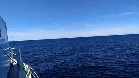
Starboard view on board the R/V Atlantis
Such clarifying moments buffer me against a dry land back drop of emotionally charged “discussions” of climate and resources.
It re-invigorates my drive to do my part in the difficult job of characterizing this planets vital composition.
I take ever increasing pride in my role as technical support for these missions. I truly love being able to help the dedicated scientists who choose to become involved in this massive undertaking. They are Heroes, all of them. I challenge you to have your own clarifying moment and become an earth scientist if you can.
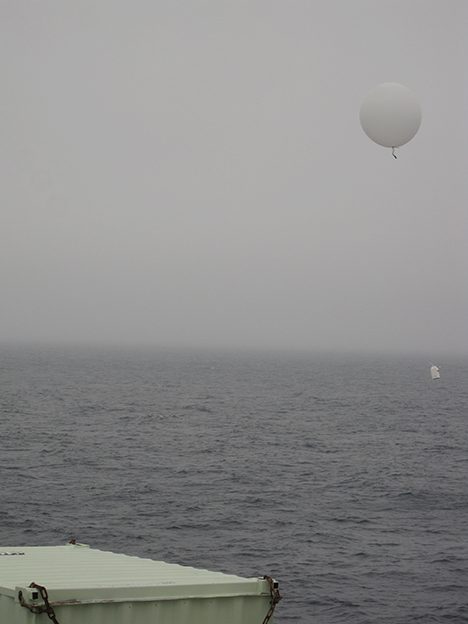
On this cruise, whilst sorting through the latest problem with the instruments, I was able to help with weather balloon launching.
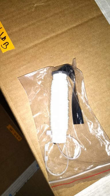
In its basic form this consisted of tying opposite ends of a string to a helium filled balloon and an electronic measuring instrument and hurling it at the sky. The electronic measuring instrument radios back to the ship what it measures for temperature, humidity and pressure along with its GPS location.
A technical term for this is Atmospheric vertical profiling and scientists use this data to help them interpret other measurements in the atmosphere. For example, they measure gas concentration on board our companion C130 Aircraft. The temperature, relative humidity and wind direction measured by the balloon electronics at different altitudes give clues to the source of the gas that they are measuring.
Here is an example of a plot generated by the balloon data.
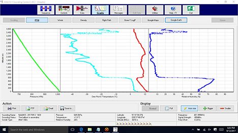
Screen shot of balloon profile of atmospheric data.
Measurements package itself resembles a cardboard takeout carton … with a hobby kit microcomputer inside and an antenna for a tail. The string like a twine roll for flying a kite with a rubber spinny thing to … well I never quite figured that bit out but it think it controls the payout rate of the string.
Rope spool for radiosonde balloon
The helium tank … a Mickey Mouse hot dog?
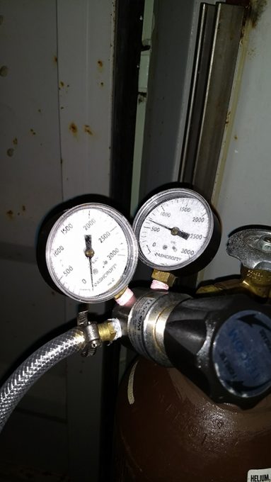
Helium tank used to fill radiosonde balloons
And the balloon … aaah well a big floppy piece of rubber… nuf said.
In addition to being useful scientifically launching these things can be challenging and fun.
If you can imagine escorting a three foot balloon madly trying to escape your grasp while flapping in 20 mile per hour winds wanting to impale itself on every pointy bit on the deck or wrap around the ship railing. Lofting it in the air only to have it flail away or come back at you and bounce off various parts of you , the ship or the water. Let’s just say each launch had its own interesting characteristic.
When the wind comes from behind the ship fast enough the balloon races ahead of the ship.
Sometimes the balloon goes horizontally for a while and then decides to deposit the sensor package unceremoniously into the ocean. In the dark, with rain and the ship bouncing at 12 knots …well you get the idea.
Here are a few of the balloon destruction surfaces .
A frame balloon target (left) and an antenna balloon target (right).
For the most part the launches are successful and a welcomed break rom other shipboard tasks.
Floating radiosonde balloon after a successful launch on board the R/V Atlantis.
All good fun … but for now. A parting verse.
We are waiting to dock in with the morning high tide
Thanks to the ship’s crew for a wonderful ride
Hoping to see you all with will to defend
And instruments in hand, at the near oceans end.
Cheers,
Cyril McCormick
Life at Sea: All Science All the Time and That’s a Good Thing….well mostly.
Any cruise aboard a research vessel feels like the days of the week are blended into one. The only timekeeping that one really has to pay attention to is the hour. When is the next instrument to be deployed over the side of the ship? When do the experiments need to be sampled again? When can I have a nap? A snack? The schedule is all science, all the time, and it’s awesome.
The R/V Atlantis is a state-of-the-art floating laboratory that has everything we need to succeed, from instrumentation and over the side equipment to highly skilled technical staff, officers and crew. It’s the perfect platform to promote and support scientific productivity for large projects like the North Atlantic Aerosols and Marine Ecosystems Study (NAAMES). During this four week research cruise the ship has hosted 13 different research groups, each studying different aspects of marine physics, chemistry, biology and atmospheric science. Linking them all is the context of a bloom forming ecosystem, the North Atlantic. The interdisciplinary nature of this cruise has forced everyone to leave their smaller focused research “boxes” and think about how the questions and approaches of other subdisciplines can complement each other to address a larger question. The question in this case being, “how do the biological and ecosystem processes associated with large phytoplankton blooms affect ocean biogeochemistry and aerosol production in the North Atlantic”?

R/V Atlantis just before departure from WHOI
We are perfectly set up to tackle the question. Within a 200-foot radius cutting through North Atlantic waters, we have our sampling gear and instrumentation, well-equipped laboratories, state rooms, a galley and most importantly, interdisciplinary colleagues with whom to share ideas, debate and hone experimental designs. While life at our home institutions provides us with similar frameworks to investigate the questions we view meaningful, many of us often reflect on a busy week wondering what exactly we accomplished. That viewpoint is largely consequence of schedules being stretched thin by teaching (or taking classes), going to scheduled meetings, to impromptu meetings, and to meetings about those meetings, and then of course, writing emails, many of which are to schedule more meetings. At sea, each of us is allotted 100mb of internet connection per day (about 10 minutes of access on a home network), which is amazing because 1) we can access the internet in one of the most remote places in the world and 2) internet activity is short, to the point, and without frivolous lingering on social media. It is nice to be able to communicate with family and friends at home, but the limited access to the internet means that the majority of our energy is spent on research activities.
The only meetings we attend are regular science briefings designed to discuss the science conducted onboard, to prepare for upcoming over-the-side operations, to consider changes to the ship course, and to be informed about changing weather patterns and sea state. These consume fractions of our days, leaving most of the hours available for science operations. Sleep has been hard to come by, but time at sea is such a rare opportunity that the objective is always to get as much done as humanly possible and worry about sleep later. To give this some context, our group’s research focuses on the microbial degradation, or decomposition, of organic matter in the vertical oceanic water column. Part of our research requires us to conduct microbial incubation experiments that are run over a week to a month. In our land-based laboratories, we might be successful in conducting five to ten of these experiments over the course of a three month period. Out here, we are finishing up our 30th microbial degradation experiment in three weeks.

Regular science briefing aboard the NAAMES cruises.
This effort requires significant multitasking and planning and is only feasible because of the lack of distraction that comes from the regular day-to-day life. This mode of operation is certainly not sustainable over the long-term, but in short (weeks) burst, it has proven to be very productive. Though these research cruises are not designed for pleasure, they provide us with the time to focus on the work we love, to interact with interdisciplinary scientists of similar interests, and to appreciate the mysteries of the natural world, reminding us why we push ourselves to do what we do.
Written by Craig A. Carlson and Nicholas Q. Huynh
Beasties from the Black
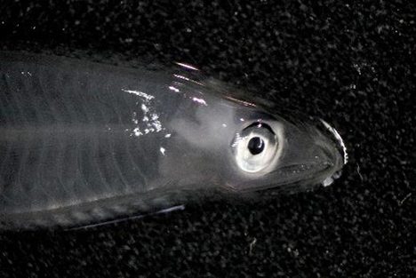
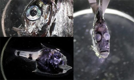
Now one thing that’s great about being part of a multi-disciplinary research cruise with a large number of scientists and their wide ranging studies is that you sometimes get to indulge in your own interests. By way of example during the 3 NAAMES cruises so far I have been able to insinuate myself into some of the work that the Peter Gaube’s Gaube lab (HTTP://gaubelab.org APL-UW) have been doing onboard. Along with their extensive Eddy feature surveys that include the deployment of Echosounders, ADCP’s and Ctd’s, they also deploy a large sampling Net Trawl. This net gets deployed down to depths of 400-500m and targets layers of migrating organisms and their predators. Over the last three cruises I have been there for every net recovery and basically jump around like a kid in a candy store waiting to see what comes up from those dark depths. I am continually amazed by what we see from each sample. The variety of these Mesopelagic marvels, figuring out what they are and being able to Photograph them is a great part of the cruise for me. I am forever learning new things about their ways of adapting to that part of the ocean that even we, as sea-going researchers seldom see. I hope that the pictures that I take do have some value other than to just myself and at least show a snap-shot of life that deserves our attention as much as the megafauna out there. The following images were taken during our most recent NAAMES3 cruise and are a brief sample of some of the Beasties from the Black that we encountered. Enjoy and feel free to comment on any images.
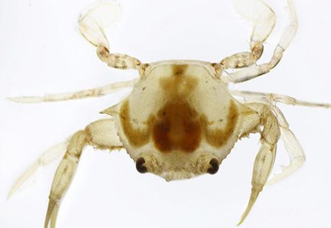
Sargassum swimming crab, STA2
Hatchet Fish, STA1,2 & 6
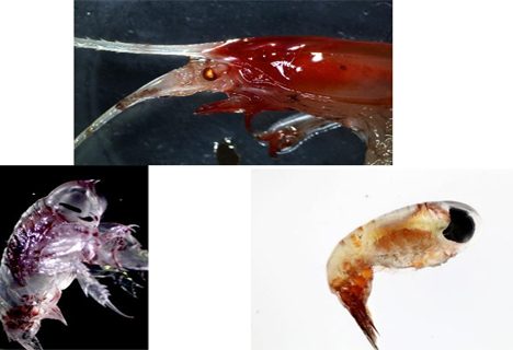
Crustaceans and Arthropods
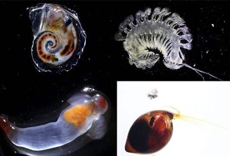
Snails, Sea Angels and Nematodes
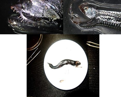
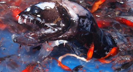
Viperfish and Dragonfish
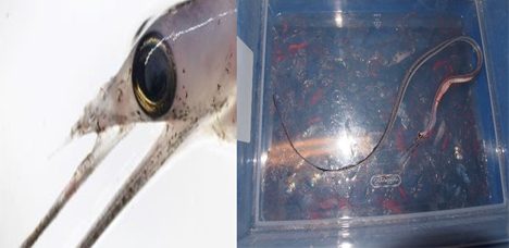
Snipe Eel
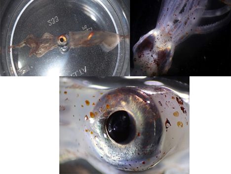
Glass Squid – Planktoteuthus
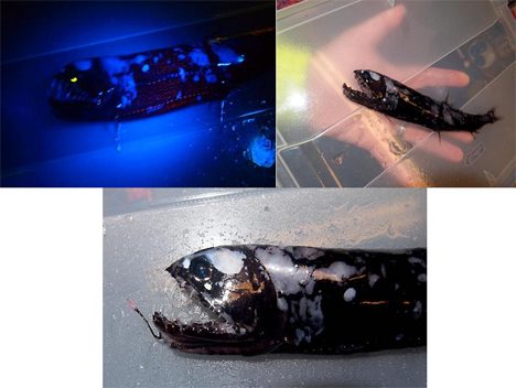
Black Dragonfish
And finally a big thank you to the crew of the R/V Atlantis! See you again soon!!!
Written by Stuart Halewood (UCSB, ERI Group)
